ATL: DORIAN - Post-Tropical - Discussion

Moderator: S2k Moderators

Message
Author
wx98
Category 5
Category 5
Posts: 1383
Joined: Sat Aug 25, 2018 9:24 pm

Re: ATL: DORIAN - Hurricane - Discussion

#8941 Postby wx98 » Thu Sep 05, 2019 11:03 pm

supercane4867 wrote:Hurricane watches are up for Nova Scotia and TS watches up for Newfoundland...Dorian is not done yet :double:

https://uploads.disquscdn.com/images/90ee583743434b1ef4b99e4840d120a04cfc7de192e8315a24f345522c2d51d6.png

This thing's hit everything but the lottery the last 2 weeks :roll:
5 likes   

User avatar
northjaxpro
S2K Supporter
S2K Supporter
Posts: 8900
Joined: Mon Sep 27, 2010 11:21 am
Location: Jacksonville, FL

Re: ATL: DORIAN - Hurricane - Discussion

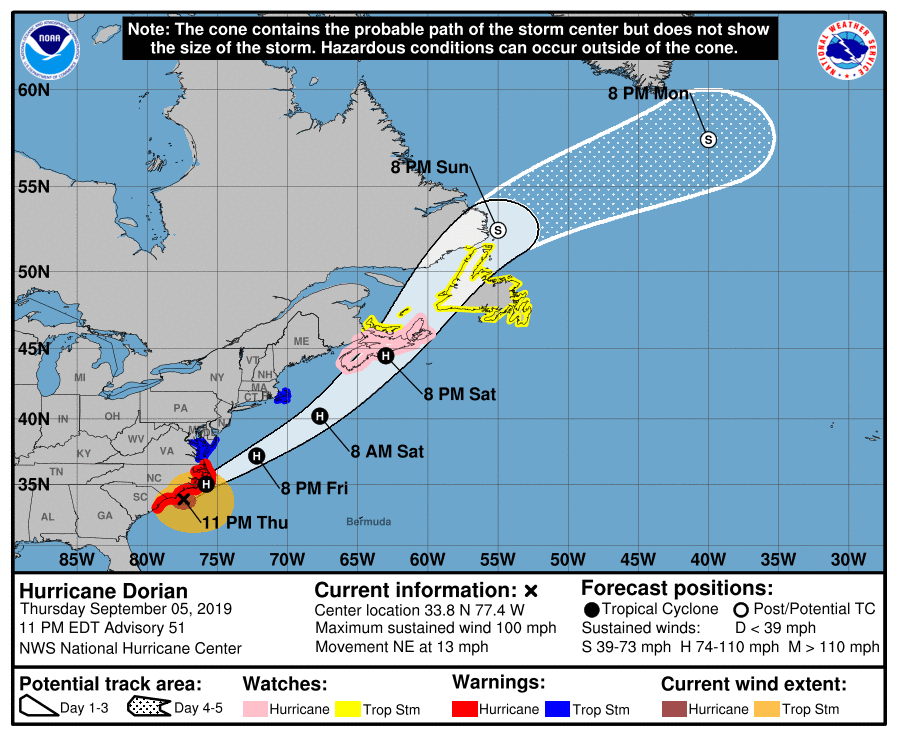
#8942 Postby northjaxpro » Thu Sep 05, 2019 11:04 pm

Amazing that Dorian NEVER did cross 80 degrees Longitude on its approach to the Southeast U.S.Coastline. Every bit of miles made a HUGE difference in this case. Just a little shift of 20 miles west would have had Dorian's eyewall somewhere on the coast or landfall in that region I specified.

This fact was a critical factor which helped spared the extreme Southeast U.S. Coast region from FL to SC coast.

NC Outer Banks looks to possibly get a landfall, but that has not happened yet or its going to be extremely real close.
Last edited by northjaxpro on Thu Sep 05, 2019 11:11 pm, edited 1 time in total.
1 likes   
NEVER, EVER SAY NEVER in the tropics and weather in general, and most importantly, with life itself!!

________________________________________________________________________________________

Fay 2008 Beryl 2012 Debby 2012 Colin 2016 Hermine 2016 Julia 2016 Matthew 2016 Irma 2017 Dorian 2019

wx98
Category 5
Category 5
Posts: 1383
Joined: Sat Aug 25, 2018 9:24 pm

Re: ATL: DORIAN - Hurricane - Discussion

#8943 Postby wx98 » Thu Sep 05, 2019 11:10 pm

northjaxpro wrote:Amazing that Dorian NEVER did cross 80 degrees Longitude on its approach to the Southeast U.S.Coastline.

This fact was a critical factor which helped spared the extreme Southeast U.S. Coast region from FL to SC coast.

NC Outer Banks looks to possibly get a landfall, but that has not happened yet or its going to be extremely real close.

It's trying its hardest not to :) Missed Cape Fear and, unless it wobbles back to the left some, it will miss Lookout and Hatteras to the SE.
2 likes   

User avatar
Evenstar
S2K Supporter
S2K Supporter
Posts: 186
Joined: Mon Aug 11, 2008 1:11 pm
Location: Chesapeake, Virginia

Re: ATL: DORIAN - Hurricane - Discussion

#8944 Postby Evenstar » Thu Sep 05, 2019 11:10 pm

storm_in_a_teacup wrote:
Evenstar wrote:
tolakram wrote:I'm still listening (it's dark) to the frying pan ocean cam, expecting the eye to move over it any time now.


Holy cow. I just listened and it sounds absolutely terrifying.


What did it sound like exactly to you? I just heard glitchy clipping from it overwhelming my speakers.


It sounded like a tornado and I've heard a tornado before.
3 likes   
I never received my Hogwarts letter, so I'm leaving the Shire and becoming a Sith Lord.


CrazyC83
Professional-Met
Professional-Met
Posts: 34002
Joined: Tue Mar 07, 2006 11:57 pm
Location: Deep South, for the first time!

Re: ATL: DORIAN - Hurricane - Discussion

#8946 Postby CrazyC83 » Thu Sep 05, 2019 11:16 pm

supercane4867 wrote:
CrazyC83 wrote:
supercane4867 wrote:Hurricane watches are up for Nova Scotia and TS watches up for Newfoundland...Dorian is not done yet :double:

https://uploads.disquscdn.com/images/90ee583743434b1ef4b99e4840d120a04cfc7de192e8315a24f345522c2d51d6.png


Nope, not by a long shot. There's about 2.5 million people in Atlantic Canada.

I remember the last hurricane to make landfall in the Atlantic Canada region tropically is Igor in 2010. Halifax got also hit pretty hard with Earl earlier in 2010


Correct. Hurricane Juan was also very significant for Halifax in 2003. This will be structurally very different than Juan, which was remarkably tropical for its latitude.
1 likes   

User avatar
1900hurricane
Category 5
Category 5
Posts: 6059
Age: 34
Joined: Fri Feb 06, 2015 12:04 pm
Location: Houston, TX
Contact:

Re: ATL: DORIAN - Hurricane - Discussion

#8947 Postby 1900hurricane » Fri Sep 06, 2019 12:02 am

2 likes   
Contract Meteorologist. TAMU & MSST. Fiercely authentic, one of a kind. We are all given free will, so choose a life meant to be lived. We are the Masters of our own Stories.
Opinions expressed are mine alone.

Follow me on Twitter at @1900hurricane : Read blogs at https://1900hurricane.wordpress.com/

PavelGaborik10
Category 1
Category 1
Posts: 455
Joined: Tue Sep 04, 2018 3:23 pm

Re: ATL: DORIAN - Hurricane - Discussion

#8948 Postby PavelGaborik10 » Fri Sep 06, 2019 2:25 am

wx98 wrote:
CrazyC83 wrote:
PavelGaborik10 wrote:
As far as his tropical life goes it appears that is likely the case, however multiple models are showing Dorian undergoing some baroclinic strengthening as it merges with another system near Atlantic Canada. Could actually be even more dangerous at that point than he is now.


Dorian will go back into the Gulf Stream tomorrow, so it is possible (I think) that it may have one more shot at intensification if shear isn't too much?

I’ve noticed that usually when these things get into the mid-latitudes as large sprawled out hurricanes with very low pressures and winds in the strong Cat 1 to weak Cat 2 range, they never seem to actually strengthen as far as the winds go. Maybe they will temporarily, but usually when the pressure falls, the winds just keep spreading out and the winds don’t really go up at all (if they do they come right back down).


The key is the winds typically hold about steady but the wind field grows exponentially. Hybrid storms can be quite dangerous.
2 likes   

wx98
Category 5
Category 5
Posts: 1383
Joined: Sat Aug 25, 2018 9:24 pm

Re: ATL: DORIAN - Hurricane - Discussion

#8949 Postby wx98 » Fri Sep 06, 2019 4:27 am

5:00 AM EDT Fri Sep 6
Location: 34.6°N 76.2°W
Moving: NE at 14 mph
Min pressure: 956 mb
Max sustained: 90 mph
0 likes   

wx98
Category 5
Category 5
Posts: 1383
Joined: Sat Aug 25, 2018 9:24 pm

Re: ATL: DORIAN - Hurricane - Discussion

#8950 Postby wx98 » Fri Sep 06, 2019 4:35 am

It’s skimming Cape Lookout and the edge of the eye is riding the barrier islands. Looks like it has no choice but to landfall on OBX near Ocracoke and Hatteras.

Cape Lookout and Morehead City have been in the eyewall for a long time but it is moving away to the NE now.

The radar presence is still remarkably good. Although the winds have come down slightly, the central pressure is hanging down at 956. It’s also starting to pick up forward speed, NE at 14 mph now.
1 likes   

User avatar
Nimbus
Category 5
Category 5
Posts: 5300
Joined: Mon Jul 19, 2004 10:54 am

Re: ATL: DORIAN - Hurricane - Discussion

#8951 Postby Nimbus » Fri Sep 06, 2019 4:42 am

bcargile wrote:Hoping NTB got lucky this time. The late push NE certainly was needed and timely. Having said that, the data seems fishy. I found many hours in the area and local reports. No winds even close to what’s reported in the 2300 discussion, or several hours before. Am I right that the NHC is providing generous estimates to keep everyone interested?


Over 100,000 customers without power this morning in NC and NHC stated that there were hurricane force gusts reported along the north Carolina coastline. Typical to get sustained 45MPH winds with those big gusts coming in the rain bands. Better news for SC where they have brought the power back up for all except 5000 customers. Hopefully the majority of the outages were just transformer breakers blowing from line slap and they can reset them by noon. Atlantic Canada is going to get a huge storm.
1 likes   

Ken711
Category 5
Category 5
Posts: 1074
Joined: Tue Aug 28, 2012 12:48 pm

Re: ATL: DORIAN - Hurricane - Discussion

#8952 Postby Ken711 » Fri Sep 06, 2019 5:25 am

Just off Cape Lookout.

The center of the eye of Hurricane Dorian is located just off the
coast of North Carolina not far from Cape Lookout. Based on data
from the Air Force Hurricane Hunters and Doppler radar velocities,
the initial intensity is set at 80 kt. This estimate is a
compromise between the flight-level winds and SFMR values. The
minimum pressure remains quite low, 956 mb, based on surface
observations and aircraft fixes. There have been several reports in
eastern North Carolina of sustained tropical-storm-force winds and
hurricane-force gusts, with the strongest winds being reported in
the northern eyewall.
0 likes   

wx98
Category 5
Category 5
Posts: 1383
Joined: Sat Aug 25, 2018 9:24 pm

Re: ATL: DORIAN - Hurricane - Discussion

#8953 Postby wx98 » Fri Sep 06, 2019 5:38 am

Recon is back in and extrapolated pressure is 956. FL winds and SFMR still support 85-90 mph.
0 likes   

wx98
Category 5
Category 5
Posts: 1383
Joined: Sat Aug 25, 2018 9:24 pm

Re: ATL: DORIAN - Hurricane - Discussion

#8954 Postby wx98 » Fri Sep 06, 2019 5:58 am

SW Okracoke Island is emerging into the eye, wouldn’t call it an offcial landfall yet though...
0 likes   

Ronel2020
Tropical Low
Tropical Low
Posts: 10
Joined: Sun Sep 10, 2017 7:54 am

Re: ATL: DORIAN - Hurricane - Discussion

#8955 Postby Ronel2020 » Fri Sep 06, 2019 6:20 am

Nimbus wrote:
bcargile wrote:Hoping NTB got lucky this time. The late push NE certainly was needed and timely. Having said that, the data seems fishy. I found many hours in the area and local reports. No winds even close to what’s reported in the 2300 discussion, or several hours before. Am I right that the NHC is providing generous estimates to keep everyone interested?


Over 100,000 customers without power this morning in NC and NHC stated that there were hurricane force gusts reported along the north Carolina coastline. Typical to get sustained 45MPH winds with those big gusts coming in the rain bands. Better news for SC where they have brought the power back up for all except 5000 customers. Hopefully the majority of the outages were just transformer breakers blowing from line slap and they can reset them by noon. Atlantic Canada is going to get a huge storm.


Pretty sure there are still over 150,000 without power in SC. Charleston County alone has approximately 90,000 out still. I'm one of them.

I was able to drive around Johns Island a little bit late yesterday afternoon. Damage is mostly limited to downed trees. I know at least one family that had a tree fall on their house, but no one was injured. The storm surge was WAY less than predicted. I think that Dorian passed our area at the right time. It was too far away to affect the 1 AM high tide and far enough north and off shore for next high tide. No damages to docks near our area that I could see either. I'm guessing that Irma and Matthew were worse than Dorian for our area.

Prayers for the Bahamas, OBX and anywhere else still in the path of Dorian.
3 likes   

User avatar
syfr
S2K Supporter
S2K Supporter
Posts: 170
Age: 106
Joined: Fri Oct 26, 2012 7:33 pm
Location: East Central NC

Re: ATL: DORIAN - Hurricane - Discussion

#8956 Postby syfr » Fri Sep 06, 2019 6:31 am

Stormy at Ocracoke Island on OBX--- functioning webcam

https://ocracokeharborinn.com/webcams/


Great place to stay by the way.
2 likes   
I'm not a meteorologist, I'm an electronics engineer. While I can probably fix your toaster oven, you're not going to learn about storms from me!

New Mexico had no hurricanes. Then I moved to NC right before Fran.....

User avatar
syfr
S2K Supporter
S2K Supporter
Posts: 170
Age: 106
Joined: Fri Oct 26, 2012 7:33 pm
Location: East Central NC

Re: ATL: DORIAN - Hurricane - Discussion

#8957 Postby syfr » Fri Sep 06, 2019 6:46 am

syfr wrote:Stormy at Ocracoke Island on OBX--- functioning webcam

https://ocracokeharborinn.com/webcams/


Great place to stay by the way.


That dock is usually about 3' above water level , so storm surge in SilverLake harbor is at least 5 feet on the island.


[imgur]<blockquote class="imgur-embed-pub" lang="en" data-id="a/JpPI48W" data-context="false" ><a href="//imgur.com/a/JpPI48W"></a></blockquote><script async src="//s.imgur.com/min/embed.js" charset="utf-8"></script>[/imgur]
0 likes   
I'm not a meteorologist, I'm an electronics engineer. While I can probably fix your toaster oven, you're not going to learn about storms from me!

New Mexico had no hurricanes. Then I moved to NC right before Fran.....

gpickett00
Category 1
Category 1
Posts: 262
Joined: Thu Sep 02, 2004 8:47 pm
Location: Satellite Beach Florida
Contact:

Re: ATL: DORIAN - Hurricane - Discussion

#8958 Postby gpickett00 » Fri Sep 06, 2019 6:55 am

Looks like it made landfall. Does this count?
2 likes   

User avatar
CronkPSU
S2K Supporter
S2K Supporter
Posts: 2014
Joined: Sun Aug 07, 2005 10:44 pm
Location: Avalon Park, FL

Re: ATL: DORIAN - Hurricane - Discussion

#8959 Postby CronkPSU » Fri Sep 06, 2019 7:06 am

gpickett00 wrote:Looks like it made landfall. Does this count?


sure looks like it to me but nothing official from NHC, they always put out an update advisory when it officially makes landfall
0 likes   
Just like Jon Snow..."I know nothing" except what I know, and most of what I know is gathered by the fine people of the NHC

wx98
Category 5
Category 5
Posts: 1383
Joined: Sat Aug 25, 2018 9:24 pm

Re: ATL: DORIAN - Hurricane - Discussion

#8960 Postby wx98 » Fri Sep 06, 2019 7:11 am

Hatteras is almost right in the middle, but the absolute center is still offshore according to recon, so it’s a toss up...
2 likes   


Return to “2019”

Who is online

Users browsing this forum: No registered users and 2 guests