ATL: DORIAN - Post-Tropical - Discussion
Moderator: S2k Moderators
-
gfsperpendicular

- Category 1

- Posts: 383
- Age: 21
- Joined: Mon Jun 19, 2017 3:04 pm
- Location: Northern Virginia
Re: ATL: DORIAN - Hurricane - Discussion
That big ol triangular eye is wobbling towards the coast at an alarming rate...
0 likes
I'm not sleeping, I'm waiting for the 0900 UTC advisory!
#1 CMC stan
#1 CMC stan
-
p1nheadlarry

- Category 2

- Posts: 672
- Age: 34
- Joined: Wed Jan 29, 2014 2:42 pm
- Location: SR County FL
Re: ATL: DORIAN - Hurricane - Discussion
gfsperpendicular wrote:That big ol triangular eye is wobbling towards the coast at an alarming rate...
Illuminati confirmed
5 likes
--;->#GoNoles--;->.

Re: ATL: DORIAN - Hurricane - Discussion
wx98 wrote:Vdogg wrote:supercane4867 wrote:These Dorian-spawned tornadoes look really intense. Some of them could be EF3+
https://twitter.com/WeatherNation/status/1169606092445274113
I don't understand why these tornadoes are so intense. Usually tropical tornadoes are very weak EF0s or EF1s.
One thing is that there is more CAPE over the Carolina coast and plenty of vertical wind shear.
Yeah, very unusual to see so large tornadoes & water spouts in a tropical system
0 likes
-
tolakram
- Admin

- Posts: 20186
- Age: 62
- Joined: Sun Aug 27, 2006 8:23 pm
- Location: Florence, KY (name is Mark)
Re: ATL: DORIAN - Hurricane - Discussion
Live visible
https://rammb-slider.cira.colostate.edu/?sat=goes-16&z=3&im=28&ts=1&st=0&et=0&speed=130&motion=loop&map=1&lat=0&opacity%5B0%5D=1&hidden%5B0%5D=0&pause=0&slider=-1&hide_controls=0&mouse_draw=0&follow_feature=0&follow_hide=0&s=rammb-slider&sec=conus&p%5B0%5D=band_02&x=6398.8359375&y=4486.87939453125
floater
https://rammb-slider.cira.colostate.edu/?sat=goes-16&z=2&im=18&ts=1&st=0&et=0&speed=130&motion=loop&map=1&lat=0&opacity%5B0%5D=1&hidden%5B0%5D=0&pause=0&slider=-1&hide_controls=0&mouse_draw=0&follow_feature=0&follow_hide=0&s=rammb-slider&sec=mesoscale_01&p%5B0%5D=band_02&x=773.4247856140137&y=1114.4539184570312
1 likes
M a r k
- - - - -
Join us in chat: Storm2K Chatroom Invite. Android and IOS apps also available.
The posts in this forum are NOT official forecasts and should not be used as such. Posts are NOT endorsed by any professional institution or STORM2K.org. For official information and forecasts, please refer to NHC and NWS products.
Re: ATL: DORIAN - Hurricane - Discussion
Charleston airport currently reporting 35 kt sustained gusting as high as 48 kt.
KCHS 051415Z AUTO 35035G48KT 1 3/4SM R15/4000VP6000FT +RA BR SCT010 OVC017 23/22 A2933 RMK AO2 PK WND 36048/1413 VIS 1 1/4V2 1/2 P0010 T02330222 $
KCHS 051415Z AUTO 35035G48KT 1 3/4SM R15/4000VP6000FT +RA BR SCT010 OVC017 23/22 A2933 RMK AO2 PK WND 36048/1413 VIS 1 1/4V2 1/2 P0010 T02330222 $
0 likes
-
Aric Dunn
- Category 5

- Posts: 21238
- Age: 43
- Joined: Sun Sep 19, 2004 9:58 pm
- Location: Ready for the Chase.
- Contact:
Re: ATL: DORIAN - Hurricane - Discussion
buoy just about in the center is down to 959mb
2 likes
Note: If I make a post that is brief. Please refer back to previous posts for the analysis or reasoning. I do not re-write/qoute what my initial post said each time.
If there is nothing before... then just ask
Space & Atmospheric Physicist, Embry-Riddle Aeronautical University,
I believe the sky is falling...
If there is nothing before... then just ask
Space & Atmospheric Physicist, Embry-Riddle Aeronautical University,
I believe the sky is falling...
Re: ATL: DORIAN - Hurricane - Discussion
Buoy 41004 is now in the eye, winds way down, pressure down to 960 mb, air temp up to 80.1F with 100% humidity
https://www.ndbc.noaa.gov/station_page. ... tion=41004
Conditions at 41004 as of
(9:50 am EDT)
1350 GMT on 09/05/2019:
Unit of Measure: Time Zone:
Click on the graph icon in the table below to see a time series plot of the last five days of that observation.
5-day plot - Wind Direction Wind Direction (WDIR): ESE ( 110 deg true )
5-day plot - Wind Speed Wind Speed (WSPD): 27.2 kts
5-day plot - Wind Gust Wind Gust (GST): 38.9 kts
5-day plot - Wave Height Wave Height (WVHT): 21.3 ft
5-day plot - Dominant Wave Period Dominant Wave Period (DPD): 11 sec
5-day plot - Average Period Average Period (APD): 8.0 sec
5-day plot - Mean Wave Direction Mean Wave Direction (MWD): SSE ( 148 deg true )
5-day plot - Atmospheric Pressure Atmospheric Pressure (PRES): 28.36 in
5-day plot - Air Temperature Air Temperature (ATMP): 80.1 °F
5-day plot - Water Temperature Water Temperature (WTMP): 82.4 °F
5-day plot - Dew Point Dew Point (DEWP): 80.1 °F
5-day plot - Heat Index Heat Index (HEAT): 87.4 °F
5-day plot - Wind Speed at 10 Meters Wind Speed at 10 meters (WSPD10M): 29.1 kts
5-day plot - Wind Speed at 10 Meters Wind Speed at 20 meters (WSPD20M): 31.1 ktss
1 likes
-
northjaxpro

- S2K Supporter

- Posts: 8900
- Joined: Mon Sep 27, 2010 11:21 am
- Location: Jacksonville, FL
Re: ATL: DORIAN - Hurricane - Discussion
Jr0d wrote:Vdogg wrote:MB may just barely escape a direct hit. Wilmington will not be so lucky however.
Judging by the latest satellite and radar, I'd say Myrtle Beach is about to be hammered. Hopefully those in vulnerable areas along the coast took the evacuation orders seriously!
Yes, keep all in prayer there and up through the N.C. Coast.
1 likes
NEVER, EVER SAY NEVER in the tropics and weather in general, and most importantly, with life itself!!
________________________________________________________________________________________
Fay 2008 Beryl 2012 Debby 2012 Colin 2016 Hermine 2016 Julia 2016 Matthew 2016 Irma 2017 Dorian 2019
________________________________________________________________________________________
Fay 2008 Beryl 2012 Debby 2012 Colin 2016 Hermine 2016 Julia 2016 Matthew 2016 Irma 2017 Dorian 2019
-
SunnyThoughts
- Category 5
- Posts: 2263
- Joined: Wed Jul 09, 2003 12:42 pm
- Location: Pensacola, Florida
Re: ATL: DORIAN - Hurricane - Discussion
https://wcti12.com/watch Live from emerald isle where the tornado destroyed so many rv's
1 likes
-
supercane4867
- Category 5
- Posts: 4966
- Joined: Wed Nov 14, 2012 10:43 am
Re: ATL: DORIAN - Hurricane - Discussion
Looks like the center is finally start turning NE, also there's a tornadic squall line approaching NC
2 likes
-
plasticup
Re: ATL: DORIAN - Hurricane - Discussion
tolakram wrote:Live visible
https://rammb-slider.cira.colostate.edu/?sat=goes-16&z=3&im=28&ts=1&st=0&et=0&speed=130&motion=loop&map=1&lat=0&opacity%5B0%5D=1&hidden%5B0%5D=0&pause=0&slider=-1&hide_controls=0&mouse_draw=0&follow_feature=0&follow_hide=0&s=rammb-slider&sec=conus&p%5B0%5D=band_02&x=6398.8359375&y=4486.87939453125
floater
https://rammb-slider.cira.colostate.edu/?sat=goes-16&z=2&im=18&ts=1&st=0&et=0&speed=130&motion=loop&map=1&lat=0&opacity%5B0%5D=1&hidden%5B0%5D=0&pause=0&slider=-1&hide_controls=0&mouse_draw=0&follow_feature=0&follow_hide=0&s=rammb-slider&sec=mesoscale_01&p%5B0%5D=band_02&x=773.4247856140137&y=1114.4539184570312
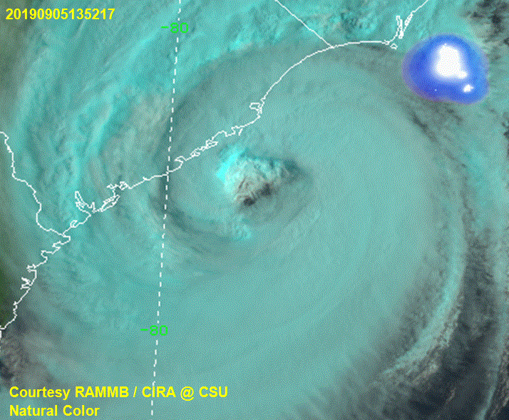
Such a weird-looking storm - huge deep eye, solid convection. I can't remember the last time I saw one like this.
2 likes
Re: ATL: DORIAN - Hurricane - Discussion
supercane4867 wrote:Looks like the center is finally start turning NE, also there's a tornadic squall line approaching NC
https://uploads.disquscdn.com/images/6bf2c80604b5cabefd5c001598e6c2a471ab9e0a1c69dfcee369e1cd026d5f69.gif
It’s like it’s trying to fake out SC and turn northeast at the last second...
1 likes
-
JBCycloneStan
- Tropical Depression

- Posts: 55
- Joined: Wed Sep 06, 2017 3:55 pm
Re: ATL: DORIAN - Hurricane - Discussion
With that big dry slot on the west side, this is starting to look like a big comma storm. Still a lot of cold cloud tops surrounding the eye, but hopefully the dry air intrusion will start to take its toll.
0 likes
-
supercane4867
- Category 5
- Posts: 4966
- Joined: Wed Nov 14, 2012 10:43 am


-
1900hurricane

- Category 5
- Posts: 6063
- Age: 34
- Joined: Fri Feb 06, 2015 12:04 pm
- Location: Houston, TX
- Contact:
Re: ATL: DORIAN - Hurricane - Discussion
Reminds me of the eyewall passes they did in Matthew '16. Might be a similar research mission.
1 likes
Contract Meteorologist. TAMU & MSST. Fiercely authentic, one of a kind. We are all given free will, so choose a life meant to be lived. We are the Masters of our own Stories.
Opinions expressed are mine alone.
Follow me on Twitter at @1900hurricane : Read blogs at https://1900hurricane.wordpress.com/
Opinions expressed are mine alone.
Follow me on Twitter at @1900hurricane : Read blogs at https://1900hurricane.wordpress.com/
-
p1nheadlarry
- Category 2
- Posts: 672
- Age: 34
- Joined: Wed Jan 29, 2014 2:42 pm
- Location: SR County FL
Re: ATL: DORIAN - Hurricane - Discussion
NHC keeps official track offshore. I still think it landfalls.
1 likes
--;->#GoNoles--;->.
-
supercane4867
- Category 5
- Posts: 4966
- Joined: Wed Nov 14, 2012 10:43 am
Re: ATL: DORIAN - Hurricane - Discussion
p1nheadlarry wrote:NHC keeps official track offshore. I still think it landfalls.
Looks like the track takes it right over OBX. Doesn't make any difference anyway, eyewall will be onshore in most part of NC
0 likes
-
jlauderdal
- S2K Supporter
- Posts: 7240
- Joined: Wed May 19, 2004 5:46 am
- Location: NE Fort Lauderdale
- Contact:
Re: ATL: DORIAN - Hurricane - Discussion
its done everything but landfall in the united states, amazingsupercane4867 wrote:Looks like the center is finally start turning NE, also there's a tornadic squall line approaching NC
https://uploads.disquscdn.com/images/6bf2c80604b5cabefd5c001598e6c2a471ab9e0a1c69dfcee369e1cd026d5f69.gif
3 likes
-
p1nheadlarry
- Category 2
- Posts: 672
- Age: 34
- Joined: Wed Jan 29, 2014 2:42 pm
- Location: SR County FL
Re: ATL: DORIAN - Hurricane - Discussion
supercane4867 wrote:p1nheadlarry wrote:NHC keeps official track offshore. I still think it landfalls.
Looks like the track takes it right over OBX. Doesn't make any difference anyway, eyewall will be onshore in most part of NC
The H at 24 hrs looks like it is over, but the forecast discussion doesn't say so. They still haven't changed the discussion where they leave room for it to be a possibility however
1 likes
--;->#GoNoles--;->.

Re: ATL: DORIAN - Hurricane - Discussion
supercane4867 wrote:p1nheadlarry wrote:NHC keeps official track offshore. I still think it landfalls.
Looks like the track takes it right over OBX. Doesn't make any difference anyway, eyewall will be onshore in most part of NC
Looks to me like they have it over the OBX as well.
1 likes
Who is online
Users browsing this forum: No registered users and 65 guests