ATL: DORIAN - Post-Tropical - Discussion
Moderator: S2k Moderators

Re: ATL: DORIAN - Hurricane - Discussion
...And it’s a cat 3 again.
5 likes
Igor 2010, Sandy 2012, Fay 2014, Gonzalo 2014, Joaquin 2015, Nicole 2016, Humberto 2019, Imelda 2025
I am only a tropical weather enthusiast. My predictions are not official and may or may not be backed by sound meteorological data. For official information, please refer to the NHC and NWS products.
I am only a tropical weather enthusiast. My predictions are not official and may or may not be backed by sound meteorological data. For official information, please refer to the NHC and NWS products.
-
romeoblade
- S2K Supporter

- Posts: 20
- Age: 43
- Joined: Sun Aug 27, 2017 12:29 pm
- Location: Springfield, LA
Re: ATL: DORIAN - Hurricane - Discussion
tarheelprogrammer wrote:Why won't you DIE DORIAN! I chose to ride it out, as did many here in Southport. It is going to be a rough night for sure. Those who do, please pray for SC and NC.
Good luck, we are a little north of you at Lake Waccamaw.
3 likes
-
supercane4867
- Category 5

- Posts: 4966
- Joined: Wed Nov 14, 2012 10:43 am
Re: ATL: DORIAN - Hurricane - Discussion
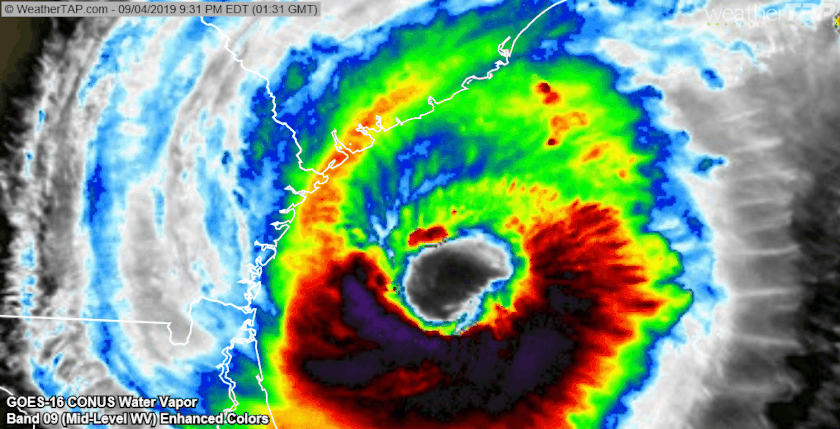
Say hello to Major Hurricane Dorian(again)
...LIFE-THREATENING STORM SURGE WITH SIGNIFICANT COASTAL FLOODING IS EXPECTED ALONG A LARGE PORTION OF THE SOUTHEAST AND MID-ATLANTIC COASTS OF THE UNITED STATES DURING THE NEXT COUPLE OF DAYS...
11:00 PM EDT Wed Sep 4
Location: 31.3°N 79.6°W
Moving: N at 7 mph
Min pressure: 955 mb
Max sustained: 115 mph
4 likes
-
supercane4867
- Category 5
- Posts: 4966
- Joined: Wed Nov 14, 2012 10:43 am
Re: ATL: DORIAN - Hurricane - Discussion
Official forecast now calls for a landfall over the Outer Banks...and another landfall as a hurricane near Halifax in Atlantic Canada!

FORECAST POSITIONS AND MAX WINDS
INIT 05/0300Z 31.3N 79.6W 100 KT 115 MPH
12H 05/1200Z 32.2N 79.4W 100 KT 115 MPH
24H 06/0000Z 33.6N 78.1W 90 KT 105 MPH
36H 06/1200Z 35.2N 75.9W 85 KT 100 MPH...OVER NC OUTER BANKS
48H 07/0000Z 37.5N 72.2W 80 KT 90 MPH
72H 08/0000Z 45.0N 62.8W 65 KT 75 MPH
96H 09/0000Z 53.5N 52.5W 50 KT 60 MPH...POST-TROP/EXTRATROP
120H 10/0000Z 58.0N 38.5W 40 KT 45 MPH...POST-TROP/EXTRATROP
2 likes
Re: ATL: DORIAN - Hurricane - Discussion
Rick Knabb on TWC seems very convinced this won’t go to Cat 4. Here’s to hoping he’s right, which I think he is.
2 likes


-
emeraldislenc
- Category 2

- Posts: 602
- Joined: Fri Aug 24, 2012 4:49 pm
- Location: Emerald Isle NC
Re: ATL: DORIAN - Hurricane - Discussion
It is back to cat 3 again. It looks like the center will be coming near to Emerald Isle.
2 likes
-
TheDreamTraveler

- Category 2
- Posts: 645
- Joined: Sun Aug 22, 2010 3:10 am
- Location: PA
Re: ATL: DORIAN - Hurricane - Discussion
wx98 wrote:Rick Knabb on TWC seems very convinced this won’t go to Cat 4. Here’s to hoping he’s right, which I think he is.
I don't know...I saw plenty of meteorologists saying this wouldn't get back to cat 3 or have any huge pressure drops. Most were convinced Dorian wasn't going to strengthen anymore than it had and wouldn't pull itself back together but it's showing that it can tonight.
6 likes

Re: ATL: DORIAN - Hurricane - Discussion
This is what the Gulf Stream will do..didn’t take long either.
7 likes
-
supercane4867
- Category 5
- Posts: 4966
- Joined: Wed Nov 14, 2012 10:43 am

Re: ATL: DORIAN - Hurricane - Discussion
Y’all need to upload some photos and videos if you experience anything worth sharing.
3 likes
-
emeraldislenc
- Category 2
- Posts: 602
- Joined: Fri Aug 24, 2012 4:49 pm
- Location: Emerald Isle NC
Re: ATL: DORIAN - Hurricane - Discussion
Yes the Gulf Stream is pretty amazing. I was concerned about that.
1 likes
Re: ATL: DORIAN - Hurricane - Discussion
Evacs still in place for the Carolina coasts? Did many choose to stay or return?
0 likes
-
SootyTern
- S2K Supporter
- Posts: 316
- Age: 57
- Joined: Sun Sep 05, 2004 5:09 pm
- Location: NYC (formerly Homestead, FL)
Re: ATL: DORIAN - Hurricane - Discussion
beoumont wrote:psyclone wrote:RL3AO wrote:The center going west of the Outer Banks would lead to some devastating storm surge. It would give them the eastern eyewall and the strongest on shore winds.
Hurricane pass cutting potential if it does sneak in over/west of cape lookout. Storm reminds me of Wilma (post Yucatan) or Ike (post Cuba)
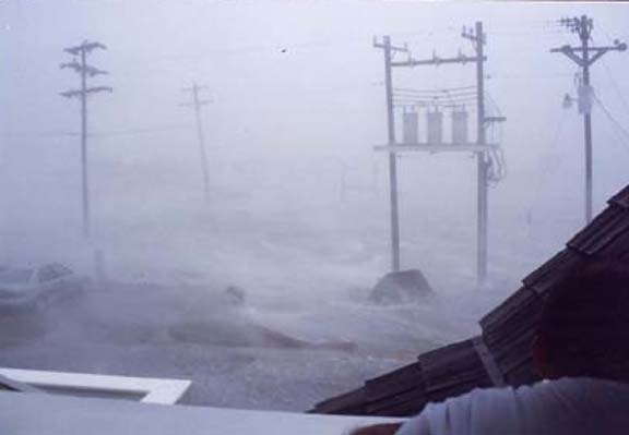
The highest tidal surge on record at Buxton (Cape Hatteras) is 10.2 feet, experienced during Hur Emily in 1993. The eye of this 115 mph , 960 mb. storm passed just offshore, putting the western wall cloud over Buxton. The record surge came on a NW wind; pushing Pamlico Sound over the island.
Below is image shot during peak surge at Buxton.
https://www.canebeard.com/i/Album/picture_clipping_1.jpg
Emily! Nobody ever brings up Emily '93. She was my first live hurricane threat; I was working that fall on the eastern shore of VA. Was both scared and curious, as I had previously lived in post-Hugo SC from '90 to '92 and post-Andrew LA earlier in '93.
Good luck to y'all in both Carolinas; the comparisons to Wilma seem pretty valid (a non-trivial event) but you probably won't have the benefit of 55 degree nights afterwards for when you are living without power. Dorian just needs to end; enough already!
1 likes
Disclaimer:
The posts in this forum are NOT official forecasts and should not be used as such. For official information, please refer to the NHC and NWS products.
Gulf Coast: Opal '95 Georges '98 / So Fla: Katrina '05 Wilma '05 Irma '17
The posts in this forum are NOT official forecasts and should not be used as such. For official information, please refer to the NHC and NWS products.
Gulf Coast: Opal '95 Georges '98 / So Fla: Katrina '05 Wilma '05 Irma '17

Re: ATL: DORIAN - Hurricane - Discussion
Steve wrote:Y’all need to upload some photos and videos if you experience anything worth sharing.
This was late last night after watching for several days.
https://youtu.be/voQw7tsFQ1w
2 likes
I'm a hurricane magnet.
Frances, Jeanne, Wilma, Matthew, and Irma
Frances, Jeanne, Wilma, Matthew, and Irma
-
emeraldislenc
- Category 2
- Posts: 602
- Joined: Fri Aug 24, 2012 4:49 pm
- Location: Emerald Isle NC
Re: ATL: DORIAN - Hurricane - Discussion
Yes evacuations still on the barrier islands. Here at Emerald Isle we started mandatory evacuations at 8 am this morning. They will continue on Tuesday. You will not be allowed to enter the island after 7 pm on Thursday. A curfew will begin on 7 pm until further notice.
2 likes
Re: ATL: DORIAN - Hurricane - Discussion
emeraldislenc wrote:Yes evacuations still on the barrier islands. Here at Emerald Isle we started mandatory evacuations at 8 am this morning. They will continue on Tuesday. You will not be allowed to enter the island after 7 pm on Thursday. A curfew will begin on 7 pm until further notice.
Thanks! Good to hear. Aren't you the mayor of Emerald Isle? Seem to remember that from Hermine or Matthew.
Last edited by sbcc on Wed Sep 04, 2019 10:44 pm, edited 2 times in total.
1 likes
-
Aric Dunn
- Category 5
- Posts: 21238
- Age: 43
- Joined: Sun Sep 19, 2004 9:58 pm
- Location: Ready for the Chase.
- Contact:
Re: ATL: DORIAN - Hurricane - Discussion
There will definitely be some PHDs given out for this storm.
6 likes
Note: If I make a post that is brief. Please refer back to previous posts for the analysis or reasoning. I do not re-write/qoute what my initial post said each time.
If there is nothing before... then just ask
Space & Atmospheric Physicist, Embry-Riddle Aeronautical University,
I believe the sky is falling...
If there is nothing before... then just ask
Space & Atmospheric Physicist, Embry-Riddle Aeronautical University,
I believe the sky is falling...

Re: ATL: DORIAN - Hurricane - Discussion
ROCK wrote:This is what the Gulf Stream will do..didn’t take long either.
You're right, I thought the dry air he was sucking in earlier today would cripple development.
But here we are back at major status and the best he's looked today.
3 likes
Personal Forecast Disclaimer:
The posts in this forum are NOT official forecast and should not be used as such. They are just the opinion of the poster and may or may not be backed by sound meteorological data. They are NOT endorsed by any professional institution or storm2k.org. For official information, please refer to the NHC and NWS products.
The posts in this forum are NOT official forecast and should not be used as such. They are just the opinion of the poster and may or may not be backed by sound meteorological data. They are NOT endorsed by any professional institution or storm2k.org. For official information, please refer to the NHC and NWS products.
Who is online
Users browsing this forum: No registered users and 51 guests