ATL: INVEST 91L - Discussion
Moderator: S2k Moderators


Re: ATL: INVEST 91L - Discussion
Planning to drive to Houston from SW Louisiana on Friday - Should the rains, that are expected, be worse at this time or should it be inland and past this area?
0 likes
Not a professional forecast by any means.
Audrey'57, Hilda'64, Betsy '65, Edith'71, Carmen'74, Danny'85, Juan'85, Andrew'92, Iniki'92 (while on vacation in Kauai), Lili'02, Rita'05, Humberto'07, Gustav'08, Ike'08, Isaac'12, Monsoonal Depression'16, Harvey'17, Barry'19, Laura'20, Delta'20, Ida'21.
Audrey'57, Hilda'64, Betsy '65, Edith'71, Carmen'74, Danny'85, Juan'85, Andrew'92, Iniki'92 (while on vacation in Kauai), Lili'02, Rita'05, Humberto'07, Gustav'08, Ike'08, Isaac'12, Monsoonal Depression'16, Harvey'17, Barry'19, Laura'20, Delta'20, Ida'21.
-
South Texas Storms

- Professional-Met

- Posts: 4263
- Joined: Thu Jun 24, 2010 12:28 am
- Location: Houston, TX
Re: ATL: INVEST 91L - Discussion
La Breeze wrote:Planning to drive to Houston from SW Louisiana on Friday - Should the rains, that are expected, be worse at this time or should it be inland and past this area?
The heavy rains will likely be over for TX and SW LA on Friday. A few lingering showers cannot be ruled out though.
1 likes
Re: ATL: INVEST 91L - Discussion
South Texas Storms wrote:La Breeze wrote:Planning to drive to Houston from SW Louisiana on Friday - Should the rains, that are expected, be worse at this time or should it be inland and past this area?
The heavy rains will likely be over for TX and SW LA on Friday. A few lingering showers cannot be ruled out though.
Fingers crossed that you are correct - thanks for the reply.
1 likes
Not a professional forecast by any means.
Audrey'57, Hilda'64, Betsy '65, Edith'71, Carmen'74, Danny'85, Juan'85, Andrew'92, Iniki'92 (while on vacation in Kauai), Lili'02, Rita'05, Humberto'07, Gustav'08, Ike'08, Isaac'12, Monsoonal Depression'16, Harvey'17, Barry'19, Laura'20, Delta'20, Ida'21.
Audrey'57, Hilda'64, Betsy '65, Edith'71, Carmen'74, Danny'85, Juan'85, Andrew'92, Iniki'92 (while on vacation in Kauai), Lili'02, Rita'05, Humberto'07, Gustav'08, Ike'08, Isaac'12, Monsoonal Depression'16, Harvey'17, Barry'19, Laura'20, Delta'20, Ida'21.

Re: ATL: INVEST 91L - Discussion
La Breeze wrote:South Texas Storms wrote:La Breeze wrote:Planning to drive to Houston from SW Louisiana on Friday - Should the rains, that are expected, be worse at this time or should it be inland and past this area?
The heavy rains will likely be over for TX and SW LA on Friday. A few lingering showers cannot be ruled out though.
Fingers crossed that you are correct - thanks for the reply.
Not a big indicator but for what it's worth...... ensemble members have begun to trend a bit further south this past run. All this implies is that until we actually have a more consolidated center, the situation remains pretty fluid. I could see a scenario where a T. S. could potentially park it's butt (or erratically drift around) off the lower to mid Texas coast for a few days (after it were to develop). 'Course, there's certainly the chance that the system never develops either but I tend to doubt that will be the case.
0 likes
Andy D
(For official information, please refer to the NHC and NWS products.)
(For official information, please refer to the NHC and NWS products.)


-
wxman57

- Moderator-Pro Met

- Posts: 23177
- Age: 68
- Joined: Sat Jun 21, 2003 8:06 pm
- Location: Houston, TX (southwest)
Re: ATL: INVEST 91L - Discussion
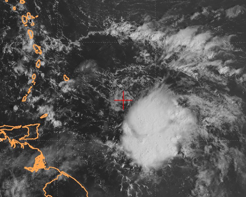
ASCAT-C pass at 1623Z showed a well-defined LLC near 19.9N / 93.8W. Strongest winds well away from the center. Convection not too organized. Very good model agreement on a track to near Tampico, MX. Strong wind shear persists north of Tampico. The farther north it tracks, the more hostile the environment. I'm thinking a 35-40kt TS into Tampico Tuesday. Wouldn't be surprised if the NHC raised development chances this evening and initiated PTC advisories.
9 likes

Re: ATL: INVEST 91L - Discussion
Salute!
Agree Hyper, I predict Barry late Monday or mid-Tuesday.
Problem with predicted path is rainfall in lower Mississippi drainage. Hopefully the sucker will dry out.
BTW, we Gulf folks keep praying to keep the El Nino cooking. They have traditionaly caused wind shear over the Gulf that keeps the storms weaker.
Michael was very unusual, although we had Opal in early October back in 1995, and it could have been worse than Mike were not for eyewall recycle a few hours before landfall.
Gums sends...
1 likes
-
cycloneye

- Admin

- Posts: 149841
- Age: 69
- Joined: Thu Oct 10, 2002 10:54 am
- Location: San Juan, Puerto Rico
Re: ATL: INVEST 91L - Discussion
0 likes
Visit the Caribbean-Central America Weather Thread where you can find at first post web cams,radars
and observations from Caribbean basin members Click Here
and observations from Caribbean basin members Click Here
-
MGC

- S2K Supporter

- Posts: 5941
- Joined: Sun Mar 23, 2003 9:05 pm
- Location: Pass Christian MS, or what is left.
Re: ATL: INVEST 91L - Discussion
91L remains poorly organized this evening. Convection is mostly scattered about a broad area of low pressure. Shear is starting to effect the NW quadrant of the disturbance. Small chance for 91L to become a TC prior to land interaction. Perhaps overnight 91L could become better organized with convection developing near the circulation center...we shall see.....MGC
0 likes
-
cycloneye
- Admin
- Posts: 149841
- Age: 69
- Joined: Thu Oct 10, 2002 10:54 am
- Location: San Juan, Puerto Rico
Re: ATL: INVEST 91L - Discussion
8 PM=60% / 60%
Tropical Weather Outlook
NWS National Hurricane Center Miami FL
800 PM EDT Sun Jun 2 2019
For the North Atlantic...Caribbean Sea and the Gulf of Mexico:
Showers and thunderstorms associated with a broad area of low
pressure over the Bay of Campeche remain disorganized. This system
is expected to move slowly northwestward toward the coast of Mexico,
and may become a tropical cyclone before it moves inland in a day or
two. Regardless of development, the disturbance will likely produce
heavy rainfall over portions of southern and eastern Mexico during
the next few days. An Air Force Reserve reconnaissance aircraft will
investigate the disturbance Monday afternoon, if necessary.
Interests along the Gulf coast of Mexico should monitor the progress
of this system.
* Formation chance through 48 hours...medium...60 percent.
* Formation chance through 5 days...medium...60 percent.
$$
Forecaster Latto/Beven
0 likes
Visit the Caribbean-Central America Weather Thread where you can find at first post web cams,radars
and observations from Caribbean basin members Click Here
and observations from Caribbean basin members Click Here
-
cycloneye
- Admin
- Posts: 149841
- Age: 69
- Joined: Thu Oct 10, 2002 10:54 am
- Location: San Juan, Puerto Rico
Re: ATL: INVEST 91L - Discussion
00z Best Track at 20.0N-94.1W and that is more north and east than past positions.

Location: 20.0°N 94.1°W
Maximum Winds: 25 kt Gusts: N/A
Minimum Central Pressure: 1007 mb
Environmental Pressure: 1009 mb
Radius of Circulation: 120 NM
Radius of Maximum Wind: 70 NM
Maximum Winds: 25 kt Gusts: N/A
Minimum Central Pressure: 1007 mb
Environmental Pressure: 1009 mb
Radius of Circulation: 120 NM
Radius of Maximum Wind: 70 NM
0 likes
Visit the Caribbean-Central America Weather Thread where you can find at first post web cams,radars
and observations from Caribbean basin members Click Here
and observations from Caribbean basin members Click Here
-
cycloneye
- Admin
- Posts: 149841
- Age: 69
- Joined: Thu Oct 10, 2002 10:54 am
- Location: San Juan, Puerto Rico
Re: ATL: INVEST 91L - Discussion
Tropical Weather Outlook
NWS National Hurricane Center Miami FL
800 AM EDT Mon Jun 3 2019
For the North Atlantic...Caribbean Sea and the Gulf of Mexico:
A broad area of low pressure is producing disorganized shower and
thunderstorm activity over the Bay of Campeche. This system is
expected to move slowly northwestward toward the northeastern coast
of Mexico, and could become a tropical cyclone before it moves
inland in a day or two. Regardless of development, the disturbance
will likely produce heavy rainfall over portions of southern and
eastern Mexico during the next few days. An Air Force Reserve
reconnaissance aircraft will investigate the disturbance this
afternoon, if necessary. Interests along the Gulf coast of Mexico
should monitor the progress of this system.
* Formation chance through 48 hours...medium...60 percent.
* Formation chance through 5 days...medium...60 percent.
$$
Forecaster Zelinsky
0 likes
Visit the Caribbean-Central America Weather Thread where you can find at first post web cams,radars
and observations from Caribbean basin members Click Here
and observations from Caribbean basin members Click Here
-
weathaguyry

- Category 5

- Posts: 1273
- Age: 22
- Joined: Wed Jun 15, 2016 5:16 am
- Location: Long Island, NY
Re: ATL: INVEST 91L - Discussion

Doesn't look like any crazy organization happened last night judging by the satellite appearance. If it continues to look like this, I'm sure they will cancel recon and possibly start lowering chances in the 2PM TWO. Who knows though, maybe today is the day this thing gets its act together.
1 likes
My posts are only my opinions and NOT official forecasts. For official forecasts, consult the National Hurricane Center or the National Weather Service.
Irene 11', Sandy 12', Fay 20’, Isaias 20’, Elsa 21’, Henri 21’, Ida 21’
Irene 11', Sandy 12', Fay 20’, Isaias 20’, Elsa 21’, Henri 21’, Ida 21’
-
cycloneye
- Admin
- Posts: 149841
- Age: 69
- Joined: Thu Oct 10, 2002 10:54 am
- Location: San Juan, Puerto Rico
Re: ATL: INVEST 91L - Discussion
12z Best Track:

Location: 20.0°N 94.9°W
Maximum Winds: 25 kt Gusts: N/A
Minimum Central Pressure: 1007 mb
Environmental Pressure: 1009 mb
Radius of Circulation: 140 NM
Radius of Maximum Wind: 90 NM
Maximum Winds: 25 kt Gusts: N/A
Minimum Central Pressure: 1007 mb
Environmental Pressure: 1009 mb
Radius of Circulation: 140 NM
Radius of Maximum Wind: 90 NM
0 likes
Visit the Caribbean-Central America Weather Thread where you can find at first post web cams,radars
and observations from Caribbean basin members Click Here
and observations from Caribbean basin members Click Here
-
cycloneye
- Admin
- Posts: 149841
- Age: 69
- Joined: Thu Oct 10, 2002 10:54 am
- Location: San Juan, Puerto Rico
Re: ATL: INVEST 91L - Discussion
1 likes
Visit the Caribbean-Central America Weather Thread where you can find at first post web cams,radars
and observations from Caribbean basin members Click Here
and observations from Caribbean basin members Click Here
-
Dean4Storms
- S2K Supporter
- Posts: 6358
- Age: 63
- Joined: Sun Aug 31, 2003 1:01 pm
- Location: Miramar Bch. FL
Re: ATL: INVEST 91L - Discussion
Looks like a heavily weighted system evolving and wondering if the current Low could lose identity and a secondary Low develop out further East of the NE Mexico Coast in the heavier convection in a couple to 3 days. We've seen that happen many times in these large gyre type evolving Lows.
1 likes
-
Aric Dunn
- Category 5
- Posts: 21238
- Age: 43
- Joined: Sun Sep 19, 2004 9:58 pm
- Location: Ready for the Chase.
- Contact:
Re: ATL: INVEST 91L - Discussion
I count at least 4 vorts rotating around. Something will consolidate it a good deal of convection builds.
.

.
0 likes
Note: If I make a post that is brief. Please refer back to previous posts for the analysis or reasoning. I do not re-write/qoute what my initial post said each time.
If there is nothing before... then just ask
Space & Atmospheric Physicist, Embry-Riddle Aeronautical University,
I believe the sky is falling...
If there is nothing before... then just ask
Space & Atmospheric Physicist, Embry-Riddle Aeronautical University,
I believe the sky is falling...
-
lrak

- S2K Supporter
- Posts: 1770
- Age: 59
- Joined: Thu Jun 21, 2007 2:48 pm
- Location: Corpus Christi, TX
Re: ATL: INVEST 91L - Discussion
It looks like the one to the East is the one to watch. 
0 likes
AKA karl
Also
Personal Forecast Disclaimer:
My posts on this forum are NOT official forecast and should not be used as such. My posts are my basic observations and are definitely not backed by any "well some" meteorological knowledge. For official information, please refer to the NHC and NWS products.
Also
Personal Forecast Disclaimer:
My posts on this forum are NOT official forecast and should not be used as such. My posts are my basic observations and are definitely not backed by any "well some" meteorological knowledge. For official information, please refer to the NHC and NWS products.
-
cycloneye
- Admin
- Posts: 149841
- Age: 69
- Joined: Thu Oct 10, 2002 10:54 am
- Location: San Juan, Puerto Rico
Re: ATL: INVEST 91L - Discussion
0 likes
Visit the Caribbean-Central America Weather Thread where you can find at first post web cams,radars
and observations from Caribbean basin members Click Here
and observations from Caribbean basin members Click Here

Who is online
Users browsing this forum: No registered users and 7 guests