ATL: DORIAN - Post-Tropical - Discussion
Moderator: S2k Moderators
-
northjaxpro

- S2K Supporter

- Posts: 8900
- Joined: Mon Sep 27, 2010 11:21 am
- Location: Jacksonville, FL
Re: ATL: DORIAN - Hurricane - Discussion
If the HWRF model run.late today ends up verifying, the inner core/eyewall of Hurricane Dorian would move due north up the Interstate 95 corridor and pass firectly through Doentown Jacksonville as a 973 mb very strong Cat 2 or possiby low end Cat 3 cyclone on Wednesfay evrening.
Last edited by northjaxpro on Sun Sep 01, 2019 7:15 pm, edited 2 times in total.
0 likes
NEVER, EVER SAY NEVER in the tropics and weather in general, and most importantly, with life itself!!
________________________________________________________________________________________
Fay 2008 Beryl 2012 Debby 2012 Colin 2016 Hermine 2016 Julia 2016 Matthew 2016 Irma 2017 Dorian 2019
________________________________________________________________________________________
Fay 2008 Beryl 2012 Debby 2012 Colin 2016 Hermine 2016 Julia 2016 Matthew 2016 Irma 2017 Dorian 2019
Re: ATL: DORIAN - Hurricane - Discussion
AutoPenalti wrote:Aric Dunn wrote:GCANE wrote:UL HIgh now positioned over NE GOM
Some afternoon popups over west FL eroding this a bit.
Steering not as strong as compared 6 hrs ago.
Expect popups to rain out shortly.
Diurnal cooling should build the UL High back up overnight.
Not seeing the trough doing much with this.
https://i.imgur.com/JgHqZYz.png
https://i.imgur.com/Fu4fwXU.gif
https://i.imgur.com/xt4H539.png
Hey GCANE the upper ridging is finally showing up on the steering maps..
http://tropic.ssec.wisc.edu/real-time/atlantic/winds/wg8dlm6.GIF
That’s the 250mb ridging that Levi was talking about right?
Does he have a video for today up yet, I haven't seen it?
0 likes
-
wxman57

- Moderator-Pro Met

- Posts: 23127
- Age: 68
- Joined: Sat Jun 21, 2003 8:06 pm
- Location: Houston, TX (southwest)
Re: RE: Re: ATL: DORIAN - Hurricane - Discussion
jlauderdal wrote:It did very well with intensitynorthjaxpro wrote:The posts in this forum are NOT official forecasts and should not be used as such. They are just the opinion of the poster and may or may not be backed by sound meteorological data. They are NOT endorsed by any professional institution or STORM2K. For official information, please refer to products from the NHC and NWS.supercane4867 wrote:Both 18z HMON and HWRF have landfall on the Cape. Sadly the state of Florida may not dodge the bullet of the decade after all
The HWRF has been very persistent showing a landfall.on the East Central Florida Coast for the past couple of days. I have been on edge about this for awhile. It may indeed end up being right
It has not been performing well with the track, and it predicts every disturbance to become a strong hurricane. I don't trust it at all. Nearly as bad as NOGAPS.
6 likes
-
supercane4867
- Category 5

- Posts: 4966
- Joined: Wed Nov 14, 2012 10:43 am
Re: ATL: DORIAN - Hurricane - Discussion
Intense eyewall lightning continues
Amazing shot from two hours ago

Amazing shot from two hours ago
9 likes

Re: ATL: DORIAN - Hurricane - Discussion
I'm going to have to make a new folder on my computer with the number of Dorian images I am saving.
10 likes
Igor 2010, Sandy 2012, Fay 2014, Gonzalo 2014, Joaquin 2015, Nicole 2016, Humberto 2019, Imelda 2025
I am only a tropical weather enthusiast. My predictions are not official and may or may not be backed by sound meteorological data. For official information, please refer to the NHC and NWS products.
I am only a tropical weather enthusiast. My predictions are not official and may or may not be backed by sound meteorological data. For official information, please refer to the NHC and NWS products.
-
Ian2401
- Category 1

- Posts: 321
- Joined: Thu Sep 14, 2017 5:55 pm
- Location: Tallahassee, Florida
- Contact:
Re: ATL: DORIAN - Hurricane - Discussion
dorian took a big lurch forward just now wonder what thats about
wobble watching continues
wobble watching continues
2 likes
B.S. Meteorology from Florida State '24 // Current M.S. Meteorology student at Florida State
Research Interests: Rapid Intensification, TC Climatology, TC Modeling
Consult the NHC for official information
Research Interests: Rapid Intensification, TC Climatology, TC Modeling
Consult the NHC for official information
Re: ATL: DORIAN - Hurricane - Discussion
supercane4867 wrote:Intense eyewall lightning continues
https://uploads.disquscdn.com/images/efec62e5340beac91bbb05d5d3d2663f54a71866d6e5b9bfc64504f030df40fb.gif
Amazing shot from two hours ago
https://i.imgur.com/n1DRD0c.jpg
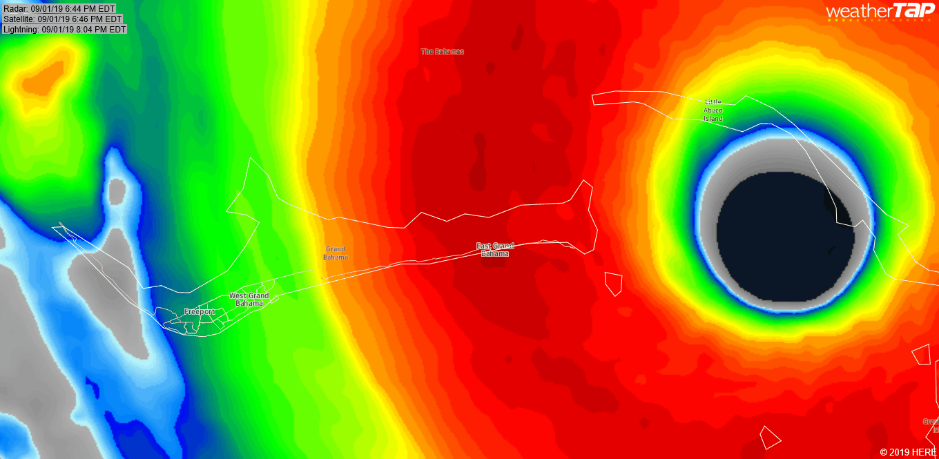
It looks like Dorian eye will run the entire length of the Grand Bahama Island, ouch!!!
1 likes

Re: ATL: DORIAN - Hurricane - Discussion
What's the longest an Atlantic Storm stayed at Cat 5?
2 likes
-
KBBOCA
- S2K Supporter
- Posts: 1559
- Joined: Fri Sep 05, 2003 5:27 am
- Location: Formerly Boca Raton, often West Africa. Currently Charlotte NC
Re: ATL: DORIAN - Hurricane - Discussion
Meteorcane wrote:RL3AO wrote:supercane4867 wrote:Maybe slightly S of due west
https://uploads.disquscdn.com/images/d187d0c91e3366aa72c863fcedb7f56d155485ab22c82c0e0c39b0baa339f5bf.gif
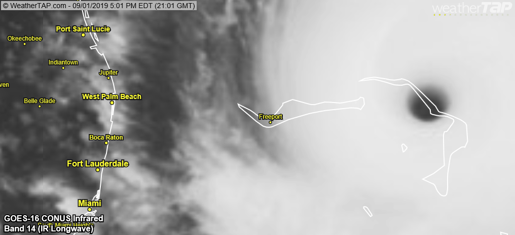
Sit back and look at this satellite image and think that most people in South Florida aren't really worried about this storm right now. That's a pretty crazy example of how confident people are in hurricane forecasts.
People take the great strides taken in numerical modeling (and meteorology as a whole) over the last couple decades for granted. 40 years ago all of south Florida would be under evacuation orders right now.
I moved to SFL in 1999 about 2 weeks after the terrible Floyd scare and the MASSIVE evacuation that caused when people didn't believe the turn would happen. I haven't reviewed the NHC forecasts from then, but yes, I do think there's been a HUGE tendency to trust the forecasts and believe the storm will turn as forecast. A lot has changed in forecasting science in the 20 years since Floyd! This storm is certainly putting that trust to the test.
1 likes
Re: ATL: DORIAN - Hurricane - Discussion
Bam Bam wrote:What's the longest an Atlantic Storm stayed at Cat 5?
Irma? 3 days as Cat 5
Last edited by edu2703 on Sun Sep 01, 2019 7:24 pm, edited 1 time in total.
1 likes
-
tropicwatch

- Category 5
- Posts: 3426
- Age: 62
- Joined: Sat Jun 02, 2007 10:01 am
- Location: Panama City Florida
- Contact:
Re: ATL: DORIAN - Hurricane - Discussion
It is not looking like it is going to follow this track.

2 likes
Tropicwatch
Agnes 72', Eloise 75, Elena 85', Kate 85', Charley 86', Florence 88', Beryl 94', Dean 95', Erin 95', Opal 95', Earl 98', Georges 98', Ivan 2004', Arlene 2005', Dennis 2005', Ida 2009' Debby 2012' Irma 2017' Michael 2018'
Agnes 72', Eloise 75, Elena 85', Kate 85', Charley 86', Florence 88', Beryl 94', Dean 95', Erin 95', Opal 95', Earl 98', Georges 98', Ivan 2004', Arlene 2005', Dennis 2005', Ida 2009' Debby 2012' Irma 2017' Michael 2018'
-
northjaxpro
- S2K Supporter
- Posts: 8900
- Joined: Mon Sep 27, 2010 11:21 am
- Location: Jacksonville, FL
Re: RE: Re: ATL: DORIAN - Hurricane - Discussion
wxman57 wrote:jlauderdal wrote:It did very well with intensitynorthjaxpro wrote:The posts in this forum are NOT official forecasts and should not be used as such. They are just the opinion of the poster and may or may not be backed by sound meteorological data. They are NOT endorsed by any professional institution or STORM2K. For official information, please refer to products from the NHC and NWS.
The HWRF has been very persistent showing a landfall.on the East Central Florida Coast for the past couple of days. I have been on edge about this for awhile. It may indeed end up being right
It has not been performing well with the track, and it predicts every disturbance to become a strong hurricane. I don't trust it at all. Nearly as bad as NOGAPS.
Well 57 I hear you. But right now, I am over here not only working overtime monitoring the storm, but I am trying to finish preps at home and even.possibly prepare to likely leave to get away from the storm by tommorow night. . I am.not discounting any model at this junncture, especially with a Category 5 monster bearing down too close for comfort here in my back yard off Florida East Coast.
Last edited by northjaxpro on Sun Sep 01, 2019 7:31 pm, edited 4 times in total.
4 likes
NEVER, EVER SAY NEVER in the tropics and weather in general, and most importantly, with life itself!!
________________________________________________________________________________________
Fay 2008 Beryl 2012 Debby 2012 Colin 2016 Hermine 2016 Julia 2016 Matthew 2016 Irma 2017 Dorian 2019
________________________________________________________________________________________
Fay 2008 Beryl 2012 Debby 2012 Colin 2016 Hermine 2016 Julia 2016 Matthew 2016 Irma 2017 Dorian 2019
-
supercane4867
- Category 5
- Posts: 4966
- Joined: Wed Nov 14, 2012 10:43 am
Re: ATL: DORIAN - Hurricane - Discussion
edu2703 wrote:Bam Bam wrote:What's the longest an Atlantic Storm stayed at Cat 5?
Irma?
Irma is correct. Over 60 hours of Straight CAT5. If you count 135kt then its over 3 full days
0 likes

Re: ATL: DORIAN - Hurricane - Discussion
Bam Bam wrote:What's the longest an Atlantic Storm stayed at Cat 5?
Officially, the 1932 Cuba Hurricane. But that was 1932... I think otherwise it is Irma. Maybe followed by Ivan?
0 likes
-
Aric Dunn
- Category 5
- Posts: 21238
- Age: 43
- Joined: Sun Sep 19, 2004 9:58 pm
- Location: Ready for the Chase.
- Contact:
Re: ATL: DORIAN - Hurricane - Discussion
Very subtle south of west motion for the last couple hours.

14 likes
Note: If I make a post that is brief. Please refer back to previous posts for the analysis or reasoning. I do not re-write/qoute what my initial post said each time.
If there is nothing before... then just ask
Space & Atmospheric Physicist, Embry-Riddle Aeronautical University,
I believe the sky is falling...
If there is nothing before... then just ask
Space & Atmospheric Physicist, Embry-Riddle Aeronautical University,
I believe the sky is falling...
Re: ATL: DORIAN - Hurricane - Discussion
Kazmit wrote:I'm going to have to make a new folder on my computer with the number of Dorian images I am saving.
Did that two days ago. I'll be happy to delete it after Weds/Thurs! Get thee behind me! If Weds/Thurs ever get here.
0 likes
-
SEASON_CANCELED

- Category 3

- Posts: 887
- Joined: Mon Jul 06, 2009 5:17 am
- Location: 8 Bit Charlie Sheen
Re: ATL: DORIAN - Hurricane - Discussion
Aric Dunn wrote:Very subtle south of west motion for the last couple hours.
https://imgshare.io/images/2019/09/01/6.gif
Can clearly see a wsw motion on miami radar
1 likes
i am a big stupid ugly moron with an ugly face and a big butt and my butt stinks and i like to kiss my own butt

-
Meteorcane

- Category 2

- Posts: 559
- Joined: Thu Jul 21, 2011 6:49 am
- Location: North Platte Nebraska
Re: ATL: DORIAN - Hurricane - Discussion
Patrick99 wrote:Michele B wrote:mutley wrote:Just out of curiosity. Does anyone truly believe that Dorian is not going to make the turn, and go right into Florida's coast somewhere?
I’ll admit it. I’m skeptical.
Personally,’when I look at “trofs” and “ridges” I don’t see a big dip that looks like it’s going to pick this thing up.
I get it. It’s not that I don’t trust NHC. I do. But hey they are human, and thus have to be spectacularly wrong some time, right? This is also a special case where they wouldn’t even have to be THAT wrong in order to preside over a catastrophe. Chugging W into WPB would be bad enough....heaven forbid a WSW drift into Broward. Neither would really be spectacularly wrong with regard to their forecast, but the general public would view it as such. There’d be hell to pay.
For me, I just have a hard time reconciling the models with 2 graphics in particular:
http://tropic.ssec.wisc.edu/real-time/m ... anim=html5
https://earth.nullschool.net/#current/w ... 22.05,2357
I look at those and think why wouldn’t this just keep going west at least in the near term, if not WSW?
I mean the official track shows essentially a W to slightly WNW movement in the short-term, it is not until during the day tomorrow that a solid N of W component to the motion should become evident. Additionally the system will continue to decelerate as well, and I think the very slow motion is throwing some people off in thinking the system is supposed to be turning NW soon. Also the NHC has issued hurricane warnings for a good portion of the Central Florida coast so people should certainly be prepared even if the "Cone centerline" depicts the system is offshore. The NHC makes it explicit the cone centerline and even the cone itself do not capture the extent of a storm's impacts, really you should be looking at the Hurricane Threats and Impacts (HTI) products that your local office issues in coordination with the NHC for that.
Last edited by Meteorcane on Sun Sep 01, 2019 7:29 pm, edited 1 time in total.
0 likes
Re: ATL: DORIAN - Hurricane - Discussion
Just had a little feeder band roll through here in Stuart. A few decent gusts with it. Still a few businesses open, hoping that they get to close up soon and be with their families.
0 likes
Frances '04, Jeanne '04, Wilma '05, Matthew '16, Irma '17, just to name a few 
Who is online
Users browsing this forum: No registered users and 20 guests