ATL: DORIAN - Post-Tropical - Discussion

Moderator: S2k Moderators

Message
Author
User avatar
Meteorcane
Category 2
Category 2
Posts: 559
Joined: Thu Jul 21, 2011 6:49 am
Location: North Platte Nebraska

Re: ATL: DORIAN - Hurricane - Discussion

#6481 Postby Meteorcane » Sun Sep 01, 2019 5:28 pm

Michele B wrote:
mutley wrote:Just out of curiosity. Does anyone truly believe that Dorian is not going to make the turn, and go right into Florida's coast somewhere?


I’ll admit it. I’m skeptical.

Personally,’when I look at “trofs” and “ridges” I don’t see a big dip that looks like it’s going to pick this thing up.


The current shortwave trough over the Ohio Valley will not really pick this thing, but it will cause the mean ridge position to shift far enough east to allow Dorian to round the western side of it. Once Dorian gains some latitude the mid-week shortwave should be what actually picks it up. Now how Dorian rounds the ridge is the big question for Florida.
6 likes   

supercane4867
Category 5
Category 5
Posts: 4966
Joined: Wed Nov 14, 2012 10:43 am

Re: ATL: DORIAN - Hurricane - Discussion

#6482 Postby supercane4867 » Sun Sep 01, 2019 5:28 pm

Looks like these flat islands just have no effect on Dorian’s intensity at all :double:

 https://twitter.com/danlindsey77/status/1168269979625459712


Image
4 likes   

MrJames
Tropical Storm
Tropical Storm
Posts: 189
Joined: Fri Sep 10, 2004 11:56 am
Location: Jax, FL

Re: ATL: DORIAN - Hurricane - Discussion

#6483 Postby MrJames » Sun Sep 01, 2019 5:30 pm

The latest shear map

Image
0 likes   

Ian2401
Category 1
Category 1
Posts: 319
Joined: Thu Sep 14, 2017 5:55 pm
Location: Tallahassee, Florida
Contact:

Re: ATL: DORIAN - Hurricane - Discussion

#6484 Postby Ian2401 » Sun Sep 01, 2019 5:30 pm

def south of west now. been doing it for about an hour now. will see if it continues. If it bounces around Great Bahama to the south like it bounced around Great Abaco to the North earlier it could have huge ramifications
0 likes   
B.S. Meteorology from Florida State '24 // Current M.S. Meteorology student at Florida State

Research Interests: Rapid Intensification, TC Climatology, TC Modeling

Consult the NHC for official information

User avatar
KWT
Category 5
Category 5
Posts: 31415
Joined: Tue Aug 17, 2004 11:02 am
Location: UK!!!

Re: ATL: DORIAN - Hurricane - Discussion

#6485 Postby KWT » Sun Sep 01, 2019 5:31 pm

michelinj wrote:
KWT wrote:
sikkar wrote:Just unbelievable IR presentation and symmetry for so long now. Those waters are pure high octane fuel.


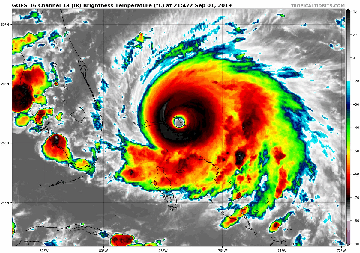
Its crazy, because there have been some really outstanding looking hurricanes in the last few years, especially Irma and Michael, but this one maybe the best out of all of them, maybe tied with Irma.

I was going to go to bed as its 11.20pm here, but I think I will stay up for this first round of recon...


Another from the UK! Recon always seems to fly in when I need to sleep! Will definitely stay up for it tho as a storm like this may not occur again in my lifetime. (Or maybe next year who knows nowadays)


I remember Wilma's ridiculous drop into the 880mbs, I can assure you it was a crazy night, especially with that tiny eye. However recon going into Patrica was also one of the maddest recon sessions as well, especially when it nearly reached the world record.

Anyway 900mbs is possible, the presentation has slightly improved again now its back over hot water again completely.
3 likes   
Personal Forecast Disclaimer:
The posts in this forum are NOT official forecast and should not be used as such. They are just the opinion of the poster and may or may not be backed by sound meteorological data. They are NOT endorsed by any professional institution or storm2k.org. For official information, please refer to the NHC and NWS products

User avatar
SeaBrz_FL
S2K Supporter
S2K Supporter
Posts: 472
Age: 69
Joined: Thu Aug 12, 2004 10:47 am
Location: Cape Canaveral, FL

Re: ATL: DORIAN - Hurricane - Discussion

#6486 Postby SeaBrz_FL » Sun Sep 01, 2019 5:31 pm

GCANE wrote:UL HIgh now positioned over NE GOM
Some afternoon popups over west FL eroding this a bit.
Steering not as strong as compared 6 hrs ago.
Expect popups to rain out shortly.
Diurnal cooling should build the UL High back up overnight.
Not seeing the trough doing much with this.


Those that survive this will never have to wonder if they are going to heaven or hell. They've already been to the latter.
9 likes   

User avatar
1900hurricane
Category 5
Category 5
Posts: 6059
Age: 34
Joined: Fri Feb 06, 2015 12:04 pm
Location: Houston, TX
Contact:

Re: ATL: DORIAN - Hurricane - Discussion

#6487 Postby 1900hurricane » Sun Sep 01, 2019 5:32 pm


That's an outer eyewall.
2 likes   
Contract Meteorologist. TAMU & MSST. Fiercely authentic, one of a kind. We are all given free will, so choose a life meant to be lived. We are the Masters of our own Stories.
Opinions expressed are mine alone.

Follow me on Twitter at @1900hurricane : Read blogs at https://1900hurricane.wordpress.com/

User avatar
tiger_deF
Category 1
Category 1
Posts: 469
Age: 24
Joined: Tue Sep 27, 2016 11:47 am

Re: ATL: DORIAN - Hurricane - Discussion

#6488 Postby tiger_deF » Sun Sep 01, 2019 5:32 pm

MrJames wrote:The latest shear map

https://i.imgur.com/AQ6k6Ym.gif


I am still pretty new to tracking but how has it possible reached and maintained category 5 strength with 20 kts of shear over the core?
1 likes   

supercane4867
Category 5
Category 5
Posts: 4966
Joined: Wed Nov 14, 2012 10:43 am

Re: ATL: DORIAN - Hurricane - Discussion

#6489 Postby supercane4867 » Sun Sep 01, 2019 5:32 pm

18z HMON initialized Dorian at 900mb then intensifies it to 891mb three hours later(which is close to current time)

Recon gonna be interesting for sure. Rita’s record may fall
1 likes   

jlauderdal
S2K Supporter
S2K Supporter
Posts: 7202
Joined: Wed May 19, 2004 5:46 am
Location: NE Fort Lauderdale
Contact:

Re: RE: Re: ATL: DORIAN - Hurricane - Discussion

#6490 Postby jlauderdal » Sun Sep 01, 2019 5:32 pm

skillz305 wrote:Feel like a Florida landfall is very likely if the cone shift anymore west...
Im done with the cone next 48 hrs at least..this is a watch the sat and radar, steering pattern situation

I will be monitoring wobble posts, ha
7 likes   

User avatar
ScottNAtlanta
Category 5
Category 5
Posts: 2419
Joined: Sat May 25, 2013 3:11 pm
Location: Atlanta, GA

Re: ATL: DORIAN - Hurricane - Discussion

#6491 Postby ScottNAtlanta » Sun Sep 01, 2019 5:32 pm

The ridge steering this is oriented toward the SW. Sort of shaped like a banana. If the west end doesnt break down quickly enough there might be some south of west motion.
0 likes   
The posts in this forum are NOT official forecast and should not be used as such. They are just the opinion of the poster and may or may not be backed by sound meteorological data. They are NOT endorsed by any professional institution or storm2k.org. For official information, please refer to the NHC and NWS products.

michelinj
Tropical Low
Tropical Low
Posts: 40
Joined: Mon Aug 06, 2018 4:59 pm

Re: ATL: DORIAN - Hurricane - Discussion

#6492 Postby michelinj » Sun Sep 01, 2019 5:34 pm


That looks like a secondary eyewall has formed? I may well be wrong tho as IR shows nothing to signify EWRC
0 likes   

SunnyThoughts
Category 5
Category 5
Posts: 2263
Joined: Wed Jul 09, 2003 12:42 pm
Location: Pensacola, Florida

Re: ATL: DORIAN - Hurricane - Discussion

#6493 Postby SunnyThoughts » Sun Sep 01, 2019 5:35 pm

HMON @ 18 hours better start turning
0 likes   

User avatar
Bunkertor
Category 5
Category 5
Posts: 3397
Joined: Tue May 09, 2006 3:48 pm

Re: ATL: DORIAN - Hurricane - Discussion

#6494 Postby Bunkertor » Sun Sep 01, 2019 5:35 pm

KWT wrote:Yeah people nearly always underestimate what winds feel like. In the UK we often get decent wind storms. My personal strongest I can remember was probably a gust around 85-90mph and it was very impressive. Even 60mph gusts will make you need to get into a decent stance as you try to walk/stand. Beyond that it gets pretty hard to walk around.

Will be interesting, what is left over when it arrives at us.
0 likes   

supercane4867
Category 5
Category 5
Posts: 4966
Joined: Wed Nov 14, 2012 10:43 am

Re: ATL: DORIAN - Hurricane - Discussion

#6495 Postby supercane4867 » Sun Sep 01, 2019 5:35 pm

1900hurricane wrote:

That's an outer eyewall.

Still in the very early stage of a potential ERC. Most likely it’s continuing to intensify for now
0 likes   

MacTavish

Re: ATL: DORIAN - Hurricane - Discussion

#6496 Postby MacTavish » Sun Sep 01, 2019 5:36 pm

1900hurricane wrote:

That's an outer eyewall.


Going to be a big eye and pretty worrisome if dorian can compete the cycle before less favorable conditions arrive
0 likes   

User avatar
Hurricane Andrew
S2K Supporter
S2K Supporter
Posts: 1891
Age: 26
Joined: Sun May 23, 2010 2:53 pm
Location: KS

Re: ATL: DORIAN - Hurricane - Discussion

#6497 Postby Hurricane Andrew » Sun Sep 01, 2019 5:36 pm

tiger_deF wrote:
MrJames wrote:The latest shear map

https://i.imgur.com/AQ6k6Ym.gif


I am still pretty new to tracking but how has it possible reached and maintained category 5 strength with 20 kts of shear over the core?

So that map shows any kind of shear, including that produced by the storm itself.
0 likes   

The Enthusiast
NREMT-AEMT, WX nerd

Irene '11, Sandy '12, Irma '17 (SAR)

"Hard to think we were born to live this way..." -Wage War

User avatar
cheezyWXguy
Category 5
Category 5
Posts: 6130
Joined: Mon Feb 13, 2006 12:29 am
Location: Dallas, TX

Re: ATL: DORIAN - Hurricane - Discussion

#6498 Postby cheezyWXguy » Sun Sep 01, 2019 5:36 pm

michelinj wrote:


That looks like a secondary eyewall has formed? I may well be wrong tho as IR shows nothing to signify EWRC

Definite second eyewall forming on radar. Good thing recon is heading in now, as this might be our last chance to determine dorians true peak strength
2 likes   

WeatherEmperor
S2K Supporter
S2K Supporter
Posts: 4806
Age: 41
Joined: Thu Sep 04, 2003 2:54 pm
Location: South Florida

Re: ATL: DORIAN - Hurricane - Discussion

#6499 Postby WeatherEmperor » Sun Sep 01, 2019 5:37 pm

cheezyWXguy wrote:
michelinj wrote:


That looks like a secondary eyewall has formed? I may well be wrong tho as IR shows nothing to signify EWRC

Definite second eyewall forming on radar. Good thing recon is heading in now, as this might be our last chance to determine dorians true peak strength


What time will recon be in the eye?


Sent from my iPhone using Tapatalk
0 likes   

User avatar
Blinhart
Category 5
Category 5
Posts: 2081
Age: 48
Joined: Thu Sep 08, 2011 3:13 pm
Location: Crowley, La.

Re: ATL: DORIAN - Hurricane - Discussion

#6500 Postby Blinhart » Sun Sep 01, 2019 5:38 pm

MacTavish wrote:
1900hurricane wrote:

That's an outer eyewall.


Going to be a big eye and pretty worrisome if dorian can compete the cycle before less favorable conditions arrive


Or it could do like a few others have just have an outer eyewall stall there and slowly expand while an inner eyewall forms and then dissipates and pushes the pressures even further down.
3 likes   
Personal Forecast Disclaimer:
The posts in this forum are NOT official forecast and should not be used as such. They are just the opinion of the poster and may or may not be backed by sound meteorological data. They are NOT endorsed by any professional institution or storm2k.org. For official information, please refer to the NHC and NWS products.


Return to “2019”

Who is online

Users browsing this forum: No registered users and 4 guests