ATL: DORIAN - Post-Tropical - Discussion
Moderator: S2k Moderators
-
Chris_in_Tampa
- Category 5

- Posts: 5101
- Age: 42
- Joined: Thu Jun 21, 2007 11:06 pm
- Location: Tampa, Florida, USA
- Contact:
Re: ATL: DORIAN - Tropical Storm - Discussion
Satellite Imagery:
https://www.star.nesdis.noaa.gov/GOES/f ... d=AL052019
From: https://www.star.nesdis.noaa.gov/GOES/
http://rammb.cira.colostate.edu/product ... r=al052019
Model products on that site: http://rammb.cira.colostate.edu/product ... r=al052019
http://hurricanecity.com/custom-satelli ... 14&lon=-58
From: https://weather.msfc.nasa.gov/GOES/
https://realearth.ssec.wisc.edu/?center ... obalir-avn
http://tropic.ssec.wisc.edu/real-time/s ... 000&loop=0
From: http://tropic.ssec.wisc.edu/
https://weather.cod.edu/satrad/?parms=g ... 24-0-100-1
https://rammb-slider.cira.colostate.edu ... 535&y=8134
https://www.tropicaltidbits.com/sat/sat ... product=ir
From: https://www.tropicaltidbits.com/sat/
https://www.weathernerds.org/satellite/floaters/
https://www.nrlmry.navy.mil/tc-bin/tc_h ... km&PROD=ir
From: https://www.nrlmry.navy.mil/TC.html
Mesoscale floater 2 imagery (which it is currently on, meaning one minute imagery):
https://www.star.nesdis.noaa.gov/GOES/meso_index.php
Then select which one it is out of usually the top two listed.
https://realearth.ssec.wisc.edu/?produc ... ew=leaflet
https://weather.cod.edu/satrad/?parms=m ... 24-0-100-1
https://weather.msfc.nasa.gov/cgi-bin/s ... ct=10p35um
https://www.tropicaltidbits.com/sat/#meso
The SLIDER product has mesoscale imagery too, but at the moment it is not showing the storm like it should, instead having outdated imagery from a prior floater position over 98L:
https://rammb-slider.cira.colostate.edu ... 000&y=1000
This SSEC site also usually has mesoscale imagery, but doesn't at the moment for this storm on this mesoscale floater:
https://www.ssec.wisc.edu/data/geo/#/an ... javascript
3 likes
Re: ATL: DORIAN - Tropical Storm - Discussion
TXNT28 KNES 241825
TCSNTL
A. 05L (NONAME)
B. 24/1800Z
C. 10.7N
D. 48.5W
E. THREE/GOES-E
F. T1.5/1.5/D1.0/24HRS
G. IR/EIR/VIS
H. REMARKS...2.5/10 BANDING FOR A DT=1.5. MET=1.0. PT=1.0. FT IS BASED
ON DT.
I. ADDL POSITIONS
NIL
...LEE
TCSNTL
A. 05L (NONAME)
B. 24/1800Z
C. 10.7N
D. 48.5W
E. THREE/GOES-E
F. T1.5/1.5/D1.0/24HRS
G. IR/EIR/VIS
H. REMARKS...2.5/10 BANDING FOR A DT=1.5. MET=1.0. PT=1.0. FT IS BASED
ON DT.
I. ADDL POSITIONS
NIL
...LEE
0 likes
Very useful information on the Dvorak Technique --
https://severe.worldweather.wmo.int/TCF ... kBeven.pdf
https://severe.worldweather.wmo.int/TCF ... kBeven.pdf
- AtlanticWind
- S2K Supporter

- Posts: 1898
- Age: 67
- Joined: Sun Aug 08, 2004 9:57 pm
- Location: Plantation,Fla
Re: ATL: DORIAN- Tropical Storm - Discussion
TheStormExpert wrote:I’m having a hard time believing that Dorian will be a hurricane in the Eastern Caribbean graveyard.
have been plenty of powerful hurricanes in the eastern carribean,they do usally need to be a least a strong tropical storm before they enter the
carribean
1 likes
- NotSparta
- Professional-Met

- Posts: 1677
- Age: 24
- Joined: Fri Aug 18, 2017 8:24 am
- Location: Naples, FL
- Contact:
Re: ATL: DORIAN - Tropical Storm - Discussion
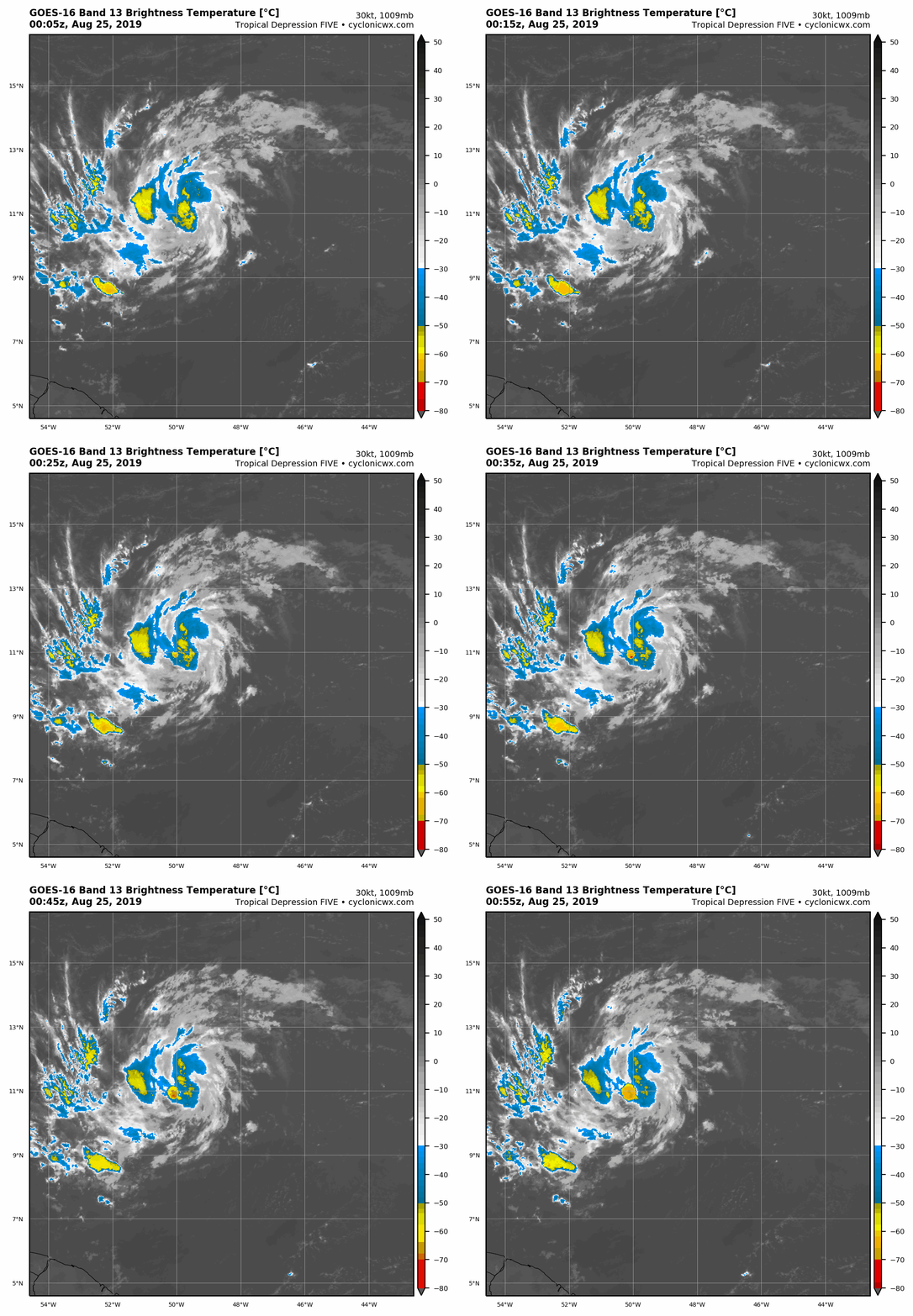
New convective burst:


6 likes
This post was probably an opinion of mine, and in no way is official. Please refer to http://www.hurricanes.gov for official tropical analysis and advisories.
My website, with lots of tropical wx graphics, including satellite and recon: http://cyclonicwx.com
My website, with lots of tropical wx graphics, including satellite and recon: http://cyclonicwx.com
- captainbarbossa19
- Professional-Met

- Posts: 1094
- Age: 27
- Joined: Wed Aug 21, 2019 11:09 pm
- Location: Beaumont, TX
Re: ATL: DORIAN- Tropical Storm - Discussion
AtlanticWind wrote:TheStormExpert wrote:I’m having a hard time believing that Dorian will be a hurricane in the Eastern Caribbean graveyard.
have been plenty of powerful hurricanes in the eastern carribean,they do usally need to be a least a strong tropical storm before they enter the
carribean
Unfortunately, Maria was a good example of not having any trouble strengthening in the eastern Caribbean.
0 likes
-
floridasun78
- Category 5

- Posts: 3755
- Joined: Sun May 17, 2009 10:16 pm
- Location: miami fl
Re: ATL: DORIAN - Tropical Storm - Discussion
not sure how PR will able take other hit again by strong hurr will be bad for them
5 likes
- Kosmo Kitty
- Tropical Wave

- Posts: 9
- Joined: Wed Sep 20, 2017 4:32 pm
- Location: South Florida
Re: ATL: DORIAN - Tropical Storm - Discussion
If it comes to Miami it will be the next weekend. 

0 likes
- Kingarabian
- S2K Supporter

- Posts: 16379
- Joined: Sat Aug 08, 2009 3:06 am
- Location: Honolulu, Hawaii
Re: ATL: DORIAN - Tropical Storm - Discussion
Yeah its IR depiction is lacking. Let's see how it looks tomorrow.
1 likes
RIP Kobe Bryant
-
Sciencerocks
- Category 5

- Posts: 10193
- Age: 40
- Joined: Thu Jul 06, 2017 1:51 am
Re: ATL: DORIAN - Tropical Storm - Discussion
Having an hard time with mid level dry air it would appear by the collapse of the convection. It will have to mix it out and refire the convection to attempt to strengthen and that maybe starting with the new blow up...
0 likes
Re: ATL: DORIAN - Tropical Storm - Discussion

ASCAT indicates max winds of 30kt. This was upgraded prematurely or has weakened since.
0 likes
Kendall -> SLO -> PBC
Memorable Storms: Katrina (for its Florida landfall...) Wilma Matthew Irma
Memorable Storms: Katrina (for its Florida landfall...) Wilma Matthew Irma
-
BYG Jacob
Re: ATL: DORIAN - Tropical Storm - Discussion
ASCAT is not infallible, and it also has well known issues with smaller storms.
7 likes
- Hypercane_Kyle
- Category 5

- Posts: 3465
- Joined: Sat Mar 07, 2015 7:58 pm
- Location: Cape Canaveral, FL
Re: ATL: DORIAN - Tropical Storm - Discussion
Ubuntwo wrote:https://media.discordapp.net/attachments/614941390698315778/614999377295179784/LATEST.png?width=676&height=676
ASCAT indicates max winds of 30kt. This was upgraded prematurely or has weakened since.
Keep in mind ASCAT has limited resolution and Dorian is a tiny, tiny tropical storm.
5 likes
My posts are my own personal opinion, defer to the National Hurricane Center (NHC) and other NOAA products for decision making during hurricane season.
- Nancy Smar
- Category 5

- Posts: 1081
- Age: 25
- Joined: Wed Aug 16, 2017 10:03 pm
Re: ATL: DORIAN - Tropical Storm - Discussion
AL, 05, 2019082500, 03, OFCL, 0, 108N, 497W, 35, 0, TS, 34, NEQ, 20, 0, 0, 20, 0, 0, 0, 45, 0, , 0, DAZ, 280, 11,
AL, 05, 2019082500, 03, OFCL, 3, 109N, 502W, 35, 1008, TS, 34, NEQ, 20, 0, 0, 20, 0, 0, 0, 45, 0, , 0, DAZ, 280, 11, , , 12, NEQ, 30, 0, 0, 30,
AL, 05, 2019082500, 03, OFCL, 12, 112N, 519W, 40, 0, TS, 34, NEQ, 30, 0, 0, 30, 0, 0, 0, 50, 0, , 0, DAZ, 280, 11,
AL, 05, 2019082500, 03, OFCL, 24, 117N, 540W, 45, 0, TS, 34, NEQ, 30, 30, 0, 30, 0, 0, 0, 55, 0, , 0, DAZ, 285, 11,
AL, 05, 2019082500, 03, OFCL, 36, 125N, 561W, 50, 0, TS, 34, NEQ, 40, 30, 20, 40, 0, 0, 0, 60, 0, , 0, DAZ, 290, 11,
AL, 05, 2019082500, 03, OFCL, 36, 125N, 561W, 50, 0, TS, 50, NEQ, 20, 0, 0, 20, 0, 0, 0, 60, 0, , 0, DAZ, 290, 11,
AL, 05, 2019082500, 03, OFCL, 48, 132N, 582W, 55, 0, TS, 34, NEQ, 40, 40, 20, 40, 0, 0, 0, 65, 0, , 0, DAZ, 290, 11,
AL, 05, 2019082500, 03, OFCL, 48, 132N, 582W, 55, 0, TS, 50, NEQ, 20, 0, 0, 20, 0, 0, 0, 65, 0, , 0, DAZ, 290, 11,
AL, 05, 2019082500, 03, OFCL, 72, 150N, 623W, 65, 0, HU, 34, NEQ, 50, 40, 30, 50, 0, 0, 0, 80, 0, , 0, DAZ, 300, 11,
AL, 05, 2019082500, 03, OFCL, 72, 150N, 623W, 65, 0, HU, 50, NEQ, 30, 20, 10, 30, 0, 0, 0, 80, 0, , 0, DAZ, 300, 11,
AL, 05, 2019082500, 03, OFCL, 96, 170N, 665W, 70, 0, HU, 34, NEQ, 0, 0, 0, 0, 0, 0, 0, 85, 0, , 0, DAZ, 295, 11,
AL, 05, 2019082500, 03, OFCL, 120, 190N, 700W, 55, 0, TS, 34, NEQ, 0, 0, 0, 0, 0, 0, 0, 65, 0, , 0, DAZ, 300, 10,
0 likes
- AubreyStorm
- Category 1

- Posts: 337
- Age: 45
- Joined: Fri Jun 16, 2017 6:21 pm
- Location: Texas, USA
Re: ATL: DORIAN - Tropical Storm - Discussion
Nancy Smar wrote:AL, 05, 2019082500, 03, OFCL, 0, 108N, 497W, 35, 0, TS, 34, NEQ, 20, 0, 0, 20, 0, 0, 0, 45, 0, , 0, DAZ, 280, 11,
AL, 05, 2019082500, 03, OFCL, 3, 109N, 502W, 35, 1008, TS, 34, NEQ, 20, 0, 0, 20, 0, 0, 0, 45, 0, , 0, DAZ, 280, 11, , , 12, NEQ, 30, 0, 0, 30,
AL, 05, 2019082500, 03, OFCL, 12, 112N, 519W, 40, 0, TS, 34, NEQ, 30, 0, 0, 30, 0, 0, 0, 50, 0, , 0, DAZ, 280, 11,
AL, 05, 2019082500, 03, OFCL, 24, 117N, 540W, 45, 0, TS, 34, NEQ, 30, 30, 0, 30, 0, 0, 0, 55, 0, , 0, DAZ, 285, 11,
AL, 05, 2019082500, 03, OFCL, 36, 125N, 561W, 50, 0, TS, 34, NEQ, 40, 30, 20, 40, 0, 0, 0, 60, 0, , 0, DAZ, 290, 11,
AL, 05, 2019082500, 03, OFCL, 36, 125N, 561W, 50, 0, TS, 50, NEQ, 20, 0, 0, 20, 0, 0, 0, 60, 0, , 0, DAZ, 290, 11,
AL, 05, 2019082500, 03, OFCL, 48, 132N, 582W, 55, 0, TS, 34, NEQ, 40, 40, 20, 40, 0, 0, 0, 65, 0, , 0, DAZ, 290, 11,
AL, 05, 2019082500, 03, OFCL, 48, 132N, 582W, 55, 0, TS, 50, NEQ, 20, 0, 0, 20, 0, 0, 0, 65, 0, , 0, DAZ, 290, 11,
AL, 05, 2019082500, 03, OFCL, 72, 150N, 623W, 65, 0, HU, 34, NEQ, 50, 40, 30, 50, 0, 0, 0, 80, 0, , 0, DAZ, 300, 11,
AL, 05, 2019082500, 03, OFCL, 72, 150N, 623W, 65, 0, HU, 50, NEQ, 30, 20, 10, 30, 0, 0, 0, 80, 0, , 0, DAZ, 300, 11,
AL, 05, 2019082500, 03, OFCL, 96, 170N, 665W, 70, 0, HU, 34, NEQ, 0, 0, 0, 0, 0, 0, 0, 85, 0, , 0, DAZ, 295, 11,
AL, 05, 2019082500, 03, OFCL, 120, 190N, 700W, 55, 0, TS, 34, NEQ, 0, 0, 0, 0, 0, 0, 0, 65, 0, , 0, DAZ, 300, 10,
Upgrade?
0 likes
The posts are NOT an official forecast. Please REFER to the NHC and NWS for official forecasts and products.
- HurricaneAndre2008
- Category 1

- Posts: 356
- Age: 28
- Joined: Wed Jul 31, 2019 9:51 pm
- Contact:
Re: ATL: DORIAN - Tropical Storm - Discussion
I think Dorian is more than 40mph.
0 likes
Cindy(2005), Katrina(2005), Rita(2005), Erin(2007), Isaac(2012)
-
AutoPenalti
- Category 5

- Posts: 4091
- Age: 29
- Joined: Mon Aug 17, 2015 4:16 pm
- Location: Ft. Lauderdale, Florida
Re: ATL: DORIAN - Tropical Storm - Discussion
Definitely weaker since this morning, that popcorn convection is firing right on schedule.
0 likes
The posts in this forum are NOT official forecasts and should not be used as such. They are just the opinion of the poster and may or may not be backed by sound meteorological data. They are NOT endorsed by any professional institution or STORM2K. For official information, please refer to products from the NHC and NWS.
Model Runs Cheat Sheet:
GFS (5:30 AM/PM, 11:30 AM/PM)
HWRF, GFDL, UKMET, NAVGEM (6:30-8:00 AM/PM, 12:30-2:00 AM/PM)
ECMWF (1:45 AM/PM)
TCVN is a weighted averaged
-
Sciencerocks
- Category 5

- Posts: 10193
- Age: 40
- Joined: Thu Jul 06, 2017 1:51 am
- AtlanticWind
- S2K Supporter

- Posts: 1898
- Age: 67
- Joined: Sun Aug 08, 2004 9:57 pm
- Location: Plantation,Fla
Re: ATL: DORIAN - Tropical Storm - Discussion
I have seen with a lot of storms in the MDR will fire convection when they reach 55W. The warmer SST's make a big difference.
3 likes
- Nancy Smar
- Category 5

- Posts: 1081
- Age: 25
- Joined: Wed Aug 16, 2017 10:03 pm
Re: ATL: DORIAN - Tropical Storm - Discussion
AubreyStorm wrote:Nancy Smar wrote:AL, 05, 2019082500, 03, OFCL, 0, 108N, 497W, 35, 0, TS, 34, NEQ, 20, 0, 0, 20, 0, 0, 0, 45, 0, , 0, DAZ, 280, 11,
AL, 05, 2019082500, 03, OFCL, 3, 109N, 502W, 35, 1008, TS, 34, NEQ, 20, 0, 0, 20, 0, 0, 0, 45, 0, , 0, DAZ, 280, 11, , , 12, NEQ, 30, 0, 0, 30,
AL, 05, 2019082500, 03, OFCL, 12, 112N, 519W, 40, 0, TS, 34, NEQ, 30, 0, 0, 30, 0, 0, 0, 50, 0, , 0, DAZ, 280, 11,
AL, 05, 2019082500, 03, OFCL, 24, 117N, 540W, 45, 0, TS, 34, NEQ, 30, 30, 0, 30, 0, 0, 0, 55, 0, , 0, DAZ, 285, 11,
AL, 05, 2019082500, 03, OFCL, 36, 125N, 561W, 50, 0, TS, 34, NEQ, 40, 30, 20, 40, 0, 0, 0, 60, 0, , 0, DAZ, 290, 11,
AL, 05, 2019082500, 03, OFCL, 36, 125N, 561W, 50, 0, TS, 50, NEQ, 20, 0, 0, 20, 0, 0, 0, 60, 0, , 0, DAZ, 290, 11,
AL, 05, 2019082500, 03, OFCL, 48, 132N, 582W, 55, 0, TS, 34, NEQ, 40, 40, 20, 40, 0, 0, 0, 65, 0, , 0, DAZ, 290, 11,
AL, 05, 2019082500, 03, OFCL, 48, 132N, 582W, 55, 0, TS, 50, NEQ, 20, 0, 0, 20, 0, 0, 0, 65, 0, , 0, DAZ, 290, 11,
AL, 05, 2019082500, 03, OFCL, 72, 150N, 623W, 65, 0, HU, 34, NEQ, 50, 40, 30, 50, 0, 0, 0, 80, 0, , 0, DAZ, 300, 11,
AL, 05, 2019082500, 03, OFCL, 72, 150N, 623W, 65, 0, HU, 50, NEQ, 30, 20, 10, 30, 0, 0, 0, 80, 0, , 0, DAZ, 300, 11,
AL, 05, 2019082500, 03, OFCL, 96, 170N, 665W, 70, 0, HU, 34, NEQ, 0, 0, 0, 0, 0, 0, 0, 85, 0, , 0, DAZ, 295, 11,
AL, 05, 2019082500, 03, OFCL, 120, 190N, 700W, 55, 0, TS, 34, NEQ, 0, 0, 0, 0, 0, 0, 0, 65, 0, , 0, DAZ, 300, 10,
Upgrade?
Yes.
2 likes
Who is online
Users browsing this forum: No registered users and 42 guests


