EPAC: FLOSSIE - Remnants

Moderator: S2k Moderators

Message
Author
User avatar
Yellow Evan
Professional-Met
Professional-Met
Posts: 15960
Age: 25
Joined: Fri Jul 15, 2011 12:48 pm
Location: Henderson, Nevada/Honolulu, HI
Contact:

Re: EPAC: INVEST 90E

#21 Postby Yellow Evan » Sat Jul 27, 2019 1:22 am

An area of low pressure accompanied by disturbed weather is located
a few hundred miles south of the Gulf of Tehuantepec. Gradual
development of this system is expected, and a tropical depression is
likely to form next week while the system moves generally westward
at 15 to 20 mph.
* Formation chance through 48 hours...low...30 percent.
* Formation chance through 5 days...high...80 percent.
0 likes   

User avatar
Kingarabian
S2K Supporter
S2K Supporter
Posts: 15462
Joined: Sat Aug 08, 2009 3:06 am
Location: Honolulu, Hawaii

Re: EPAC: INVEST 90E

#22 Postby Kingarabian » Sat Jul 27, 2019 1:27 am

GFS Legacy very bullish on this:
Image
0 likes   
RIP Kobe Bryant

User avatar
Yellow Evan
Professional-Met
Professional-Met
Posts: 15960
Age: 25
Joined: Fri Jul 15, 2011 12:48 pm
Location: Henderson, Nevada/Honolulu, HI
Contact:

Re: EPAC: INVEST 90E

#23 Postby Yellow Evan » Sat Jul 27, 2019 1:47 am

Image

0z ECMWF a bit weaker than past runs.
0 likes   

User avatar
Kingarabian
S2K Supporter
S2K Supporter
Posts: 15462
Joined: Sat Aug 08, 2009 3:06 am
Location: Honolulu, Hawaii

Re: EPAC: INVEST 90E

#24 Postby Kingarabian » Sat Jul 27, 2019 1:55 am

Yellow Evan wrote:[url]https://i.imgur.com/Iiz0Svh.png[url]

0z ECMWF a bit weaker than past runs.


It still shows a pretty solid system. Remember last year it kept initializing peak Hector and Lane too weak.
0 likes   
RIP Kobe Bryant

User avatar
Yellow Evan
Professional-Met
Professional-Met
Posts: 15960
Age: 25
Joined: Fri Jul 15, 2011 12:48 pm
Location: Henderson, Nevada/Honolulu, HI
Contact:

Re: EPAC: INVEST 90E

#25 Postby Yellow Evan » Sat Jul 27, 2019 2:07 am

Kingarabian wrote:
Yellow Evan wrote:[url]https://i.imgur.com/Iiz0Svh.png[url]

0z ECMWF a bit weaker than past runs.


It still shows a pretty solid system. Remember last year it kept initializing peak Hector and Lane too weak.


Especially with Lane with the ECMWF insiting incorrectly that it wouldn’t threaten Hawaii for days.

Honestly I’ve seen enough model support, even for if it’s just of and on, to be convinced this and 99E can become potent hurricanes. Hector and Lane along with Ignacio 15 are examples of strong hurricanes with often shaky model support during its formative stages.
1 likes   

User avatar
Kingarabian
S2K Supporter
S2K Supporter
Posts: 15462
Joined: Sat Aug 08, 2009 3:06 am
Location: Honolulu, Hawaii

Re: EPAC: INVEST 90E

#26 Postby Kingarabian » Sat Jul 27, 2019 2:36 am

Both 00z HWRF and 00z HMON blow this up with the HWRF showing it reach Cat.4 status:
Image
0 likes   
RIP Kobe Bryant

Astromanía
Category 2
Category 2
Posts: 744
Age: 25
Joined: Sat Aug 25, 2018 10:34 pm
Location: Monterrey, N.L, México

Re: EPAC: INVEST 90E

#27 Postby Astromanía » Sat Jul 27, 2019 4:45 am

I remember Barbara wasn´t to hype by the models and at the end it reach almost a category five so imagine what could happen with this system. :eek:
0 likes   

User avatar
cycloneye
Admin
Admin
Posts: 139695
Age: 67
Joined: Thu Oct 10, 2002 10:54 am
Location: San Juan, Puerto Rico

Re: EPAC: INVEST 90E

#28 Postby cycloneye » Sat Jul 27, 2019 5:48 am

06z GFS over Hilo.

Image
0 likes   
Visit the Caribbean-Central America Weather Thread where you can find at first post web cams,radars
and observations from Caribbean basin members Click Here

Chris90
Category 2
Category 2
Posts: 640
Age: 34
Joined: Thu Jun 01, 2017 9:36 pm

Re: EPAC: INVEST 90E

#29 Postby Chris90 » Sat Jul 27, 2019 6:09 am

Astromanía wrote:I remember Barbara wasn´t to hype by the models and at the end it reach almost a category five so imagine what could happen with this system. :eek:


I wouldn't hold out hope that future Flossie will receive an official Cat 5 classification, it's a hard status to achieve in the EPAC/CPAC due to Dvorak and the associated constraints combined with the fact this basin doesn't receive the recon coverage the ATL does due to less storms threatening land (which really is a positive that outweighs the disappointment of less recon.)

Future Flossie definitely has great potential to receive recon coverage in the future if it does threaten Hawaii, but it becomes a matter of timing. It's got to achieve the perfect combination of being enough of a threat to Hawaii to receive recon while also being in an intensification phase like Hector and Lane last year. That would be its best chance at getting Cat 5 classification if it's providing the necessary data. As it is right now, and based on model trends, I think it'll be on the downswing when recon starts flying if it even becomes a recon covered threat to Hawaii. A lot can change in just a few days. We'll have to see how things progress.
1 likes   
Solar Aquarian
Lunar Cancerian
:uarrow: Sagittarian

User avatar
cycloneye
Admin
Admin
Posts: 139695
Age: 67
Joined: Thu Oct 10, 2002 10:54 am
Location: San Juan, Puerto Rico

Re: EPAC: INVEST 90E

#30 Postby cycloneye » Sat Jul 27, 2019 6:36 am

An area of low pressure accompanied by disturbed weather is located
a few hundred miles south-southwest of the Gulf of Tehuantepec.
Gradual development of this system is expected, and a tropical
depression is likely to form early next week while the system moves
generally westward at 15 to 20 mph.
* Formation chance through 48 hours...low...30 percent.
* Formation chance through 5 days...high...80 percent.
0 likes   
Visit the Caribbean-Central America Weather Thread where you can find at first post web cams,radars
and observations from Caribbean basin members Click Here

User avatar
cycloneye
Admin
Admin
Posts: 139695
Age: 67
Joined: Thu Oct 10, 2002 10:54 am
Location: San Juan, Puerto Rico

Re: EPAC: INVEST 90E

#31 Postby cycloneye » Sat Jul 27, 2019 8:02 am

As of 12:00 UTC Jul 27, 2019:

Location: 9.0°N 99.0°W
Maximum Winds: 20 kt Gusts: nan kt
Minimum Central Pressure: 1010 mb
Environmental Pressure: 1012 mb
Radius of Circulation: 150 NM
Radius of Maximum Wind: 90 NM


Image
0 likes   
Visit the Caribbean-Central America Weather Thread where you can find at first post web cams,radars
and observations from Caribbean basin members Click Here

User avatar
wxman57
Moderator-Pro Met
Moderator-Pro Met
Posts: 22512
Age: 66
Joined: Sat Jun 21, 2003 8:06 pm
Location: Houston, TX (southwest)

Re: EPAC: INVEST 90E

#32 Postby wxman57 » Sat Jul 27, 2019 8:14 am

The only Hawaiian island ever struck directly by a hurricane is Kauai, from Dot in 1959 and Iniki in 1992. That's something to consider when looking at the 06Z GFS. Doesn't mean it can't happen, but Hawaii is very hard for hurricanes to reach from the east. All (2) hits have been from the south.

Image

Image
4 likes   

User avatar
Kingarabian
S2K Supporter
S2K Supporter
Posts: 15462
Joined: Sat Aug 08, 2009 3:06 am
Location: Honolulu, Hawaii

Re: EPAC: INVEST 90E

#33 Postby Kingarabian » Sat Jul 27, 2019 10:28 am

wxman57 wrote:The only Hawaiian island ever struck directly by a hurricane is Kauai, from Dot in 1959 and Iniki in 1992. That's something to consider when looking at the 06Z GFS. Doesn't mean it can't happen, but Hawaii is very hard for hurricanes to reach from the east. All (2) hits have been from the south.

http://wxman57.com/images/Hawaii.JPG

http://wxman57.com/images/Hawaii2.JPG

Certainly. But Lane 2018 and Iselle 2014 proved you don't need a direct hit or a hurricane hit to cause substantial damage to infrastructure that's probably below 3rd world-esque.
0 likes   
RIP Kobe Bryant

User avatar
cycloneye
Admin
Admin
Posts: 139695
Age: 67
Joined: Thu Oct 10, 2002 10:54 am
Location: San Juan, Puerto Rico

Re: EPAC: INVEST 90E

#34 Postby cycloneye » Sat Jul 27, 2019 10:59 am

12z GFS is stronger than past runs thru 96 hours.

Image
0 likes   
Visit the Caribbean-Central America Weather Thread where you can find at first post web cams,radars
and observations from Caribbean basin members Click Here

Ntxw
Storm2k Moderator
Storm2k Moderator
Posts: 21565
Joined: Wed Oct 21, 2009 6:34 pm
Location: DFW, Texas

Re: EPAC: INVEST 90E

#35 Postby Ntxw » Sat Jul 27, 2019 11:35 am

Going to make a guess this peaks at 130kts. If it threatens Hawaii and stays slightly to the south (like Lane) with recon then 140kts.
3 likes   
The above post and any post by Ntxw is NOT an official forecast and should not be used as such. It is just the opinion of the poster and may or may not be backed by sound meteorological data. It is NOT endorsed by any professional institution including Storm2k. For official information, please refer to NWS products.

  Help support Storm2K!
Help Support Storm2K

User avatar
cycloneye
Admin
Admin
Posts: 139695
Age: 67
Joined: Thu Oct 10, 2002 10:54 am
Location: San Juan, Puerto Rico

Re: EPAC: INVEST 90E

#36 Postby cycloneye » Sat Jul 27, 2019 12:29 pm

An area of low pressure accompanied by disturbed weather is located
a few hundred miles south of Acapulco, Mexico. Conditions are
favorable for development, and a tropical depression is expected to
form early next week while the system moves generally westward at 15
to 20 mph.
* Formation chance through 48 hours...medium...50 percent.
* Formation chance through 5 days...high...90 percent.
0 likes   
Visit the Caribbean-Central America Weather Thread where you can find at first post web cams,radars
and observations from Caribbean basin members Click Here

User avatar
cycloneye
Admin
Admin
Posts: 139695
Age: 67
Joined: Thu Oct 10, 2002 10:54 am
Location: San Juan, Puerto Rico

Re: EPAC: INVEST 90E

#37 Postby cycloneye » Sat Jul 27, 2019 1:32 pm

As of 18:00 UTC Jul 27, 2019:

Location: 9.4°N 101.0°W
Maximum Winds: 20 kt Gusts: nan kt
Minimum Central Pressure: 1010 mb
Environmental Pressure: 1012 mb
Radius of Circulation: 150 NM
Radius of Maximum Wind: 90 NM
0 likes   
Visit the Caribbean-Central America Weather Thread where you can find at first post web cams,radars
and observations from Caribbean basin members Click Here

User avatar
wxman57
Moderator-Pro Met
Moderator-Pro Met
Posts: 22512
Age: 66
Joined: Sat Jun 21, 2003 8:06 pm
Location: Houston, TX (southwest)

Re: EPAC: INVEST 90E

#38 Postby wxman57 » Sat Jul 27, 2019 3:12 pm

Kingarabian wrote:
wxman57 wrote:The only Hawaiian island ever struck directly by a hurricane is Kauai, from Dot in 1959 and Iniki in 1992. That's something to consider when looking at the 06Z GFS. Doesn't mean it can't happen, but Hawaii is very hard for hurricanes to reach from the east. All (2) hits have been from the south.

http://wxman57.com/images/Hawaii.JPG

http://wxman57.com/images/Hawaii2.JPG

Certainly. But Lane 2018 and Iselle 2014 proved you don't need a direct hit or a hurricane hit to cause substantial damage to infrastructure that's probably below 3rd world-esque.


True. Iselle decoupled as it approached the Big Island. Lane passed "safely" south then turned northward, driving some very heavy rain into the islands. If this storm turns north to the west of the islands, they may not get hit by strong wind but there would be the potential for heavy rain.
1 likes   

User avatar
gatorcane
S2K Supporter
S2K Supporter
Posts: 23499
Age: 46
Joined: Sun Mar 13, 2005 3:54 pm
Location: Boca Raton, FL

Re: EPAC: INVEST 90E

#39 Postby gatorcane » Sat Jul 27, 2019 3:16 pm

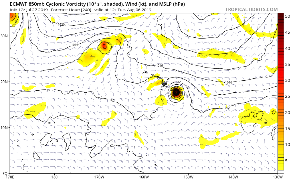
12Z ECMWF approaching Hawaii:

Image
0 likes   

User avatar
Kingarabian
S2K Supporter
S2K Supporter
Posts: 15462
Joined: Sat Aug 08, 2009 3:06 am
Location: Honolulu, Hawaii

Re: EPAC: INVEST 90E

#40 Postby Kingarabian » Sat Jul 27, 2019 3:25 pm

gatorcane wrote:12Z ECMWF approaching Hawaii:

[url]https://i.postimg.cc/bNKSfMR8/ecmwf-uv850-vort-cpac-11.png[url]


Also if you split the track with the GFS it will show a hit. 12z EPS mean also shows a ht. Fortunately it's 10 days out.
0 likes   
RIP Kobe Bryant


Return to “2019”

Who is online

Users browsing this forum: No registered users and 6 guests