EPAC: BARBARA - Remnants

Moderator: S2k Moderators

Message
Author
User avatar
cycloneye
Admin
Admin
Posts: 145277
Age: 68
Joined: Thu Oct 10, 2002 10:54 am
Location: San Juan, Puerto Rico

Re: EPAC: BARBARA - Hurricane

#161 Postby cycloneye » Mon Jul 01, 2019 3:42 pm

New peak up to 120 kts.

...BARBARA BECOMES A HURRICANE...EXPECTED TO STRENGTHEN TO A MAJOR
HURRICANE ON TUESDAY...


SUMMARY OF 200 PM PDT...2100 UTC...INFORMATION
----------------------------------------------
LOCATION...11.5N 118.5W
ABOUT 970 MI...1560 KM SW OF THE SOUTHERN TIP OF BAJA CALIFORNIA
MAXIMUM SUSTAINED WINDS...85 MPH...140 KM/H
PRESENT MOVEMENT...W OR 275 DEGREES AT 16 MPH...26 KM/H
MINIMUM CENTRAL PRESSURE...983 MB...29.03 INCHES


Hurricane Barbara Discussion Number 6
NWS National Hurricane Center Miami FL EP022019
200 PM PDT Mon Jul 01 2019

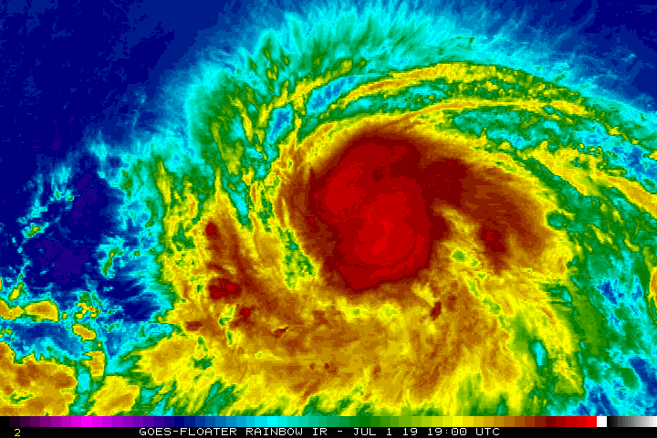
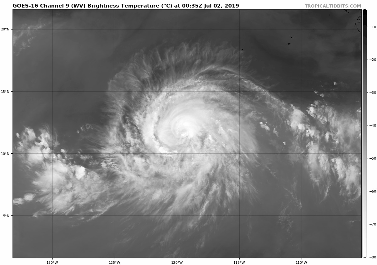
The inner-core structure of Barbara has improved markedly throughout
the day, with microwave imagery hinting that an eye is beginning to
develop. In addition, banding features have increased and the
cyclone's outflow is well-established in all quadrants. A recent
scatterometer pass showed that the wind field has expanded with
tropical-storm-force winds extending up to 140 n mi from the center.
The initial intensity is increased to 75 kt based on an average of
the latest satellite intensity estimates, making Barbara the second
hurricane of the 2019 season.

There are favorable environmental conditions in place for rapid
intensification (RI) to occur over the next 24 to 36 hours. The
SHIPS-model RI indices indicate about 60 percent chance for a 30-kt
increase in wind speed over the next 24 hours, and nearly a 50
percent chance for a 35-kt increase over the next 24 hours. The
latest NHC intensity forecast has been adjusted slightly higher
through 60 hours, and lies along or near the upper end of the
latest guidance given the expected conducive environment. After 60
hours, Barbara is expected to begin to move into a drier environment
and over cooler SSTs, while approaching a region of increasing
southwesterly shear. This will induce a weakening trend that will
continue through the end of the forecast period.

Barbara continues to move just north of due west at 14 kt. The
ridge to the north of the cyclone that is steering it westward will
weaken somewhat over the next couple of days, which will cause the
forward motion of the cyclone to decrease along with a turn to the
west-northwest and possibly even briefly northwest. The ridge
will re-strengthen later on in the forecast period, which will
result in a turn back to the west-northwest to west with an increase
in forward speed. The track guidance has shifted northward,
especially beyond 72 hours, and the NHC forecast track has been
adjusted in that direction. However, this forecast lies on the
southern side of the track guidance envelope, closest to the latest
ECMWF guidance.

FORECAST POSITIONS AND MAX WINDS

INIT 01/2100Z 11.5N 118.5W 75 KT 85 MPH
12H 02/0600Z 12.0N 120.4W 90 KT 105 MPH
24H 02/1800Z 12.6N 122.7W 110 KT 125 MPH
36H 03/0600Z 13.3N 125.0W 120 KT 140 MPH
48H 03/1800Z 14.0N 126.7W 120 KT 140 MPH
72H 04/1800Z 16.0N 129.9W 100 KT 115 MPH
96H 05/1800Z 17.5N 133.5W 75 KT 85 MPH
120H 06/1800Z 18.5N 138.0W 50 KT 60 MPH

$$
Forecaster Latto/Cangialosi
3 likes   
Visit the Caribbean-Central America Weather Thread where you can find at first post web cams,radars
and observations from Caribbean basin members Click Here

User avatar
Kingarabian
S2K Supporter
S2K Supporter
Posts: 15979
Joined: Sat Aug 08, 2009 3:06 am
Location: Honolulu, Hawaii

Re: EPAC: BARBARA - Hurricane

#162 Postby Kingarabian » Mon Jul 01, 2019 4:24 pm

Warm spot now evident on visible imagery.
Image
0 likes   
RIP Kobe Bryant

User avatar
storm_in_a_teacup
Category 1
Category 1
Posts: 421
Joined: Wed Aug 16, 2017 5:01 pm
Location: Huntsville, Alabama (originally from Houston)
Contact:

Re: EPAC: BARBARA - Tropical Storm

#163 Postby storm_in_a_teacup » Mon Jul 01, 2019 4:49 pm


Also reminds me a lot of the processes thought to be behind microquasar and AGN variability, though of course those processes are even more unalike from what we’re seeing here.
0 likes   
I know I can't straddle the atmosphere...just a tiny storm in your teacup, girl.

User avatar
Kingarabian
S2K Supporter
S2K Supporter
Posts: 15979
Joined: Sat Aug 08, 2009 3:06 am
Location: Honolulu, Hawaii

Re: EPAC: BARBARA - Hurricane

#164 Postby Kingarabian » Mon Jul 01, 2019 5:07 pm

Fresh AMSR2 pass shows a closed off Cyan ring and a Pink ring trying to do the same. So looks like the core is firmly in place and its now about building and strengthening an eyewall.
Image

However 85GHZ imagery from the same AMSR2 pass shows it's still trying to mix out some dry air:
Image
4 likes   
RIP Kobe Bryant

Chris90
Category 2
Category 2
Posts: 646
Age: 35
Joined: Thu Jun 01, 2017 9:36 pm

Re: EPAC: BARBARA - Hurricane

#165 Postby Chris90 » Mon Jul 01, 2019 5:43 pm

:uarrow: Core continues to improve from even just a few hours ago. She is definitely primed to do some serious RI.
She's a brick house.
That lady's stacked and that's a fact :wink:.
5 likes   
Solar Aquarian
Lunar Cancerian
:uarrow: Sagittarian

User avatar
Kingarabian
S2K Supporter
S2K Supporter
Posts: 15979
Joined: Sat Aug 08, 2009 3:06 am
Location: Honolulu, Hawaii

Re: EPAC: BARBARA - Hurricane

#166 Postby Kingarabian » Mon Jul 01, 2019 6:32 pm

Chris90 wrote::uarrow: Core continues to improve from even just a few hours ago. She is definitely primed to do some serious RI.
She's a brick house.
That lady's stacked and that's a fact :wink:.

F15 SSMIS pass shows continued organization:
Image
2 likes   
RIP Kobe Bryant

Chris90
Category 2
Category 2
Posts: 646
Age: 35
Joined: Thu Jun 01, 2017 9:36 pm

Re: EPAC: BARBARA - Hurricane

#167 Postby Chris90 » Mon Jul 01, 2019 6:40 pm

Kingarabian wrote:
Chris90 wrote::uarrow: Core continues to improve from even just a few hours ago. She is definitely primed to do some serious RI.
She's a brick house.
That lady's stacked and that's a fact :wink:.

F15 SSMIS pass shows continued organization:
https://i.imgur.com/rUCzADb.jpg


I'm gonna guess intensity estimates are probably shooting just a little too low right now. If this were a recon storm I wouldn't be surprised if there was data to support 85-90 kts right now. When that eye finally clears on satellite, estimates will take a jump.
2 likes   
Solar Aquarian
Lunar Cancerian
:uarrow: Sagittarian

User avatar
Kingarabian
S2K Supporter
S2K Supporter
Posts: 15979
Joined: Sat Aug 08, 2009 3:06 am
Location: Honolulu, Hawaii

Re: EPAC: BARBARA - Hurricane

#168 Postby Kingarabian » Mon Jul 01, 2019 7:18 pm

Also we can see outflow continue to be better established north and northwest of the system. Clear sign that shear is now favorable.
1 likes   
RIP Kobe Bryant

User avatar
Kingarabian
S2K Supporter
S2K Supporter
Posts: 15979
Joined: Sat Aug 08, 2009 3:06 am
Location: Honolulu, Hawaii

Re: EPAC: BARBARA - Hurricane

#169 Postby Kingarabian » Mon Jul 01, 2019 7:37 pm

SAB is a bit late but they went up to T4.5. Will help when Barbara RI's.
TXPZ21 KNES 020023
TCSENP

A. 02E (BARBARA)

B. 02/0000Z

C. 11.8N

D. 119.0W

E. ONE/GOES-W

F. T4.5/4.5/D1.5/24HRS

G. IR/EIR/VIS

H. REMARKS...15/10 BANDING RESULTS IN A DT OF 4.5. MET IS 4.0 AND PT
IS 4.5. FT IS BASED ON DT.

I. ADDL POSITIONS

NIL


...ZHU
1 likes   
RIP Kobe Bryant

User avatar
cycloneye
Admin
Admin
Posts: 145277
Age: 68
Joined: Thu Oct 10, 2002 10:54 am
Location: San Juan, Puerto Rico

Re: EPAC: BARBARA - Hurricane

#170 Postby cycloneye » Mon Jul 01, 2019 8:06 pm

Up to 80 kts.


Location: 11.6°N 119.2°W
Maximum Winds: 80 kt Gusts: N/A
Minimum Central Pressure: 981 mb
Environmental Pressure: 1009 mb
Radius of Circulation: 150 NM
Radius of Maximum Wind: 15 NM
0 likes   
Visit the Caribbean-Central America Weather Thread where you can find at first post web cams,radars
and observations from Caribbean basin members Click Here

Chris90
Category 2
Category 2
Posts: 646
Age: 35
Joined: Thu Jun 01, 2017 9:36 pm

Re: EPAC: BARBARA - Hurricane

#171 Postby Chris90 » Mon Jul 01, 2019 8:14 pm

Eye looks as if it is in the beginning stages of clearing out, and there are new hot towers firing around it in the eyewall.
I know Jimena '15 was mentioned a couple of times, but right now she is reminding me quite a bit of Fernanda '17.
1 likes   
Solar Aquarian
Lunar Cancerian
:uarrow: Sagittarian

User avatar
Kingarabian
S2K Supporter
S2K Supporter
Posts: 15979
Joined: Sat Aug 08, 2009 3:06 am
Location: Honolulu, Hawaii

Re: EPAC: BARBARA - Hurricane

#172 Postby Kingarabian » Mon Jul 01, 2019 8:30 pm

ADT has scene type as "EYE" and raw Ts shot up to 5.6. NHC will need to go 90kts at the next advisory at this rate.
1 likes   
RIP Kobe Bryant

User avatar
Ntxw
Storm2k Moderator
Storm2k Moderator
Posts: 22783
Joined: Wed Oct 21, 2009 6:34 pm
Location: DFW, Texas

Re: EPAC: BARBARA - Hurricane

#173 Postby Ntxw » Mon Jul 01, 2019 9:16 pm

Here we go..fireworks. Will quickly become cat 4 once the eye clears.

Image

UW - CIMSS
ADVANCED DVORAK TECHNIQUE
ADT-Version 9.0
Tropical Cyclone Intensity Algorithm

----- Current Analysis -----
Date : 02 JUL 2019 Time : 015033 UTC
Lat : 11:38:59 N Lon : 119:33:50 W


CI# /Pressure/ Vmax
4.6 / 976.5mb/ 79.6kt


Final T# Adj T# Raw T#
4.6 4.6 6.0

Estimated radius of max. wind based on IR :N/A km

Center Temp : -41.1C Cloud Region Temp : -70.6C

Scene Type : EYE


Image
4 likes   
The above post and any post by Ntxw is NOT an official forecast and should not be used as such. It is just the opinion of the poster and may or may not be backed by sound meteorological data. It is NOT endorsed by any professional institution including Storm2k. For official information, please refer to NWS products.

  Help support Storm2K!
Help Support Storm2K

User avatar
cycloneye
Admin
Admin
Posts: 145277
Age: 68
Joined: Thu Oct 10, 2002 10:54 am
Location: San Juan, Puerto Rico

Re: EPAC: BARBARA - Hurricane

#174 Postby cycloneye » Mon Jul 01, 2019 9:33 pm

Cat 2 at 85 kts.

BULLETIN
Hurricane Barbara Advisory Number 7
NWS National Hurricane Center Miami FL EP022019
800 PM PDT Mon Jul 01 2019

...BARBARA CONTINUES TO RAPIDLY STRENGTHEN...
...EXPECTED TO BECOME A MAJOR HURRICANE ON TUESDAY...


SUMMARY OF 800 PM PDT...0300 UTC...INFORMATION
----------------------------------------------
LOCATION...11.7N 119.8W
ABOUT 1010 MI...1625 KM SW OF THE SOUTHERN TIP OF BAJA CALIFORNIA
MAXIMUM SUSTAINED WINDS...100 MPH...155 KM/H
PRESENT MOVEMENT...W OR 280 DEGREES AT 15 MPH...24 KM/H
MINIMUM CENTRAL PRESSURE...979 MB...28.91 INCHES


Hurricane Barbara Discussion Number 7
NWS National Hurricane Center Miami FL EP022019
800 PM PDT Mon Jul 01 2019

Passive microwave imagery over the past 6 hours indicates that the
inner-core convection of Barbara has continued to consolidate and a
ragged low- to mid-level eye has formed. However, a pronounced dry
intrusion has periodically worked its way into the center of the
convective cloud mass, resulting in brief erosions of the eyewall.
Despite the dry air, bursts of deep convection have been developing
near the center and the most recent hi-resolution GOES-17 visible
satellite images suggest that a more robust eyewall is possibly
developing. Dvorak satellite intensity estimates are T4.5/77 kt
from TAFB and SAB, and UW-CIMSS ADT and SATCON values are T4.5/77
kt and 80 kt, respectively. Given the occasional appearance of a
ragged cloud-filled eye in visible satellite imagery, the initial
intensity has been increased to 85 kt for this advisory, meaning
that Barbara has rapidly intensified during the past 24 hours.

Barbara's initial motion is 280/13 kt. There remains no significant
change to the previous track forecast rationale. Barbara should
turn toward the west-northwest shortly, and that general motion is
forecast to continue for the next 36-48 hours. After that time, a
passing shortwave trough is expected to weaken the ridge to the
north of the hurricane, allowing Barbara to move more poleward. In
the 96-120 hour period, however, the ridge is forecast to build back
in, forcing Barbara back toward the west. The new NHC track
forecast is very similar to the previous advisory track, and lies
close to a blend of the TVCN, HCCA, and FSSE consensus models.

The combination of low vertical wind shear, an expanding upper-level
outflow regime, a moist mid-level environment, and SSTs greater than
28 deg C is expected to persist for at least the next 36 hours,
allowing Barbara to continue to rapidly strengthen during that time.
By 48 hours, however, steady weakening is expected to begin due to a
probable eyewall replacement cycle, the beginning of cold upwelling,
and increasing southwesterly wind shear. On days 4 and 5, more
rapid weakening is forecast due to Barbara moving over sub-26 deg C
water temperatures and into vertical wind shear conditions of more
than 20 kt. The new official intensity forecast is similar to the
previous advisory, and is a little above the consensus guidance
throughout the entire forecast period, closer to the Decay-SHIPS
model.


FORECAST POSITIONS AND MAX WINDS

INIT 02/0300Z 11.7N 119.8W 85 KT 100 MPH
12H 02/1200Z 12.3N 121.7W 95 KT 110 MPH
24H 03/0000Z 12.9N 124.0W 110 KT 125 MPH
36H 03/1200Z 13.6N 125.9W 120 KT 140 MPH
48H 04/0000Z 14.4N 127.7W 115 KT 130 MPH
72H 05/0000Z 16.4N 131.0W 85 KT 100 MPH
96H 06/0000Z 18.0N 134.7W 65 KT 75 MPH
120H 07/0000Z 18.7N 139.6W 45 KT 50 MPH

$$
Forecaster Stewart
0 likes   
Visit the Caribbean-Central America Weather Thread where you can find at first post web cams,radars
and observations from Caribbean basin members Click Here

User avatar
Kingarabian
S2K Supporter
S2K Supporter
Posts: 15979
Joined: Sat Aug 08, 2009 3:06 am
Location: Honolulu, Hawaii

Re: EPAC: BARBARA - Hurricane

#175 Postby Kingarabian » Mon Jul 01, 2019 10:33 pm

Still pushing out WPAC esque convection:
Image
1 likes   
RIP Kobe Bryant

Astromanía
Category 2
Category 2
Posts: 779
Age: 26
Joined: Sat Aug 25, 2018 10:34 pm
Location: Monterrey, N.L, México

Re: EPAC: BARBARA - Hurricane

#176 Postby Astromanía » Mon Jul 01, 2019 11:20 pm

I already have my popcorn :wink: ACE :uarrow: :uarrow: :uarrow:
1 likes   

User avatar
Kingarabian
S2K Supporter
S2K Supporter
Posts: 15979
Joined: Sat Aug 08, 2009 3:06 am
Location: Honolulu, Hawaii

Re: EPAC: BARBARA - Hurricane

#177 Postby Kingarabian » Tue Jul 02, 2019 12:25 am

Its Dvorak presentation is teetering towards a 7.0 if the white and cold grays wrap around that warm spot..

Image
1 likes   
RIP Kobe Bryant

Chris90
Category 2
Category 2
Posts: 646
Age: 35
Joined: Thu Jun 01, 2017 9:36 pm

Re: EPAC: BARBARA - Hurricane

#178 Postby Chris90 » Tue Jul 02, 2019 12:59 am

Kingarabian wrote:Its Dvorak presentation is teetering towards a 7.0 if the white and cold grays wrap around that warm spot..

https://i.imgur.com/sohCV6W.gif


I was thinking along the same lines, and I think it is already a major. These convective bursts keep overshooting and obscuring the eye, and it reminds me of ATL Maria '17 in that an eye is there, it's just obscured by all the heavy convection. Maria didn't clear out an eye until she was nearly a Cat 5.
0 likes   
Solar Aquarian
Lunar Cancerian
:uarrow: Sagittarian

User avatar
Kingarabian
S2K Supporter
S2K Supporter
Posts: 15979
Joined: Sat Aug 08, 2009 3:06 am
Location: Honolulu, Hawaii

Re: EPAC: BARBARA - Hurricane

#179 Postby Kingarabian » Tue Jul 02, 2019 1:41 am

Chris90 wrote:
Kingarabian wrote:Its Dvorak presentation is teetering towards a 7.0 if the white and cold grays wrap around that warm spot..

https://i.imgur.com/sohCV6W.gif


I was thinking along the same lines, and I think it is already a major. These convective bursts keep overshooting and obscuring the eye, and it reminds me of ATL Maria '17 in that an eye is there, it's just obscured by all the heavy convection. Maria didn't clear out an eye until she was nearly a Cat 5.

SAB says its a major up to 5.5. My hunch with all that cold convection its stronger.

It's really tough to know without recon. Just have to hope that it meets that requirementson Dvorak to get it assigned a 7.0+
1 likes   
RIP Kobe Bryant

Tailspin

Re: EPAC: BARBARA - Hurricane

#180 Postby Tailspin » Tue Jul 02, 2019 2:09 am

Image

Seeing a borderline cat3 myself on this image.
0 likes   


Return to “2019”

Who is online

Users browsing this forum: No registered users and 2 guests