
EPAC: BARBARA - Remnants
Moderator: S2k Moderators
-
Kingarabian

- S2K Supporter

- Posts: 16384
- Joined: Sat Aug 08, 2009 3:06 am
- Location: Honolulu, Hawaii
Re: EPAC: BARBARA - Tropical Storm
Now this is much better. I would say its a hurricane now.
2 likes
RIP Kobe Bryant

Re: EPAC: BARBARA - Tropical Storm
Mid level eye is definitely there, but on 37Ghz imagery, it doesn't look like it has fully worked down yet. With the way she's blowing up though, I doubt it takes too much longer.
2 likes
Solar Aquarian
Lunar Cancerian
 Sagittarian
Lunar Cancerian
-
Tailspin

-
cycloneye

- Admin

- Posts: 149846
- Age: 69
- Joined: Thu Oct 10, 2002 10:54 am
- Location: San Juan, Puerto Rico
Re: EPAC: BARBARA - Tropical Storm
Tropical Storm Barbara Discussion Number 4
NWS National Hurricane Center Miami FL EP022019
200 AM PDT Mon Jul 01 2019
Although earlier microwave imagery indicated that Barbara was still
being affected by moderate northwesterly shear, the upper-level
outflow has expanded overnight and the center appears to be more
embedded within the area of very cold cloud tops. A couple of
earlier ASCAT passes revealed peak winds of 50 kt, and a much larger
area of tropical-storm-force winds over the eastern semicircle of
the cyclone than previously analyzed. Due to the typical
undersampling of peak winds in the ASCAT instrument, the initial
intensity has been increased to 55 kt, which is also in good
agreement with the latest TAFB Dvorak intensity estimate, and ADT
and SATCON estimates from UW/CIMSS.
As mentioned in the previous advisory, the global models continue
to forecast a reduction in the deep-layer vertical wind shear
during the next couple of days while Barbara moves over warm sea
surface temperatures. These conditions are expected to allow steady
to perhaps rapid strengthening over the next couple of days. The
SHIPS, FSSE, and HCCA models are quite aggressive and predict rapid
strengthening during the next 24 to 36 h, while the HWRF and HMON
models are somewhat lower. Given the current structure of the
cyclone, the NHC forecast is a little below the more aggressive
models, but still predicts significant strengthening during the
next 24 to 48 hours. After 72 hours, cooler waters and increasing
southwesterly shear are expected to cause gradual weakening.
The initial motion estimate is 275/18 kt. A deep-layer ridge to
the north of the storm is forecast to gradually weaken over the
next several days. This should cause Barbara to slow down and turn
west-northwestward within the next day or so. By 96 h, the ridge
is forecast to build westward which should cause the cyclone to turn
back toward the west. While the dynamical models generally
agree on the overall scenario there are some differences in the
predicted forward speed and how far north Barbara will move. The
NHC forecast splits these differences and lies near the middle of
the guidance envelope, closest to the Florida State Superensemble.
FORECAST POSITIONS AND MAX WINDS
INIT 01/0900Z 11.2N 115.8W 55 KT 65 MPH
12H 01/1800Z 11.5N 117.9W 65 KT 75 MPH
24H 02/0600Z 11.9N 120.5W 80 KT 90 MPH
36H 02/1800Z 12.4N 122.7W 95 KT 110 MPH
48H 03/0600Z 13.0N 124.7W 105 KT 120 MPH
72H 04/0600Z 14.5N 128.3W 105 KT 120 MPH
96H 05/0600Z 16.3N 132.0W 85 KT 100 MPH
120H 06/0600Z 17.2N 136.2W 70 KT 80 MPH
$$
Forecaster Brown
0 likes
Visit the Caribbean-Central America Weather Thread where you can find at first post web cams,radars
and observations from Caribbean basin members Click Here
and observations from Caribbean basin members Click Here
-
cycloneye
- Admin
- Posts: 149846
- Age: 69
- Joined: Thu Oct 10, 2002 10:54 am
- Location: San Juan, Puerto Rico
Re: EPAC: BARBARA - Tropical Storm
SAB up to 3.5
TXPZ21 KNES 011227
TCSENP
A. 02E (BARBARA)
B. 01/1200Z
C. 11.3N
D. 116.7W
E. THREE/GOES-W
F. T3.5/3.5/D1.5/24HRS
G. IR/EIR/SWIR/GMI
H. REMARKS...SYSTEM CHARACTERIZED BY 7.5/10 BANDING ON A LOG-10
SCALE. DT=3.0 MET=3.0 PT=3.5. FT IS BASED ON PT DUE TO IMPRESSIVE 0731
GMI MICROWAVE IMAGE SHOWING SIGNIFICANT BANDING.
I. ADDL POSITIONS
01/0731Z 11.0N 115.5W GMI
...FISHER
0 likes
Visit the Caribbean-Central America Weather Thread where you can find at first post web cams,radars
and observations from Caribbean basin members Click Here
and observations from Caribbean basin members Click Here
-
cycloneye
- Admin
- Posts: 149846
- Age: 69
- Joined: Thu Oct 10, 2002 10:54 am
- Location: San Juan, Puerto Rico
Re: EPAC: BARBARA - Tropical Storm
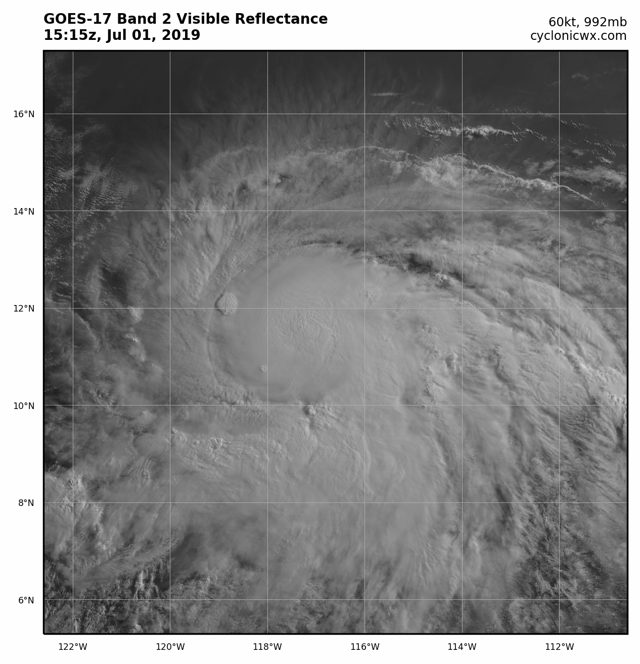
Almost a Hurricane on 12z Best Track:
Location: 11.3°N 116.6°W
Maximum Winds: 60 kt Gusts: N/A
Minimum Central Pressure: 992 mb
Environmental Pressure: 1010 mb
Radius of Circulation: 150 NM
Radius of Maximum Wind: 30 NM
Location: 11.3°N 116.6°W
Maximum Winds: 60 kt Gusts: N/A
Minimum Central Pressure: 992 mb
Environmental Pressure: 1010 mb
Radius of Circulation: 150 NM
Radius of Maximum Wind: 30 NM
0 likes
Visit the Caribbean-Central America Weather Thread where you can find at first post web cams,radars
and observations from Caribbean basin members Click Here
and observations from Caribbean basin members Click Here
-
cycloneye
- Admin
- Posts: 149846
- Age: 69
- Joined: Thu Oct 10, 2002 10:54 am
- Location: San Juan, Puerto Rico
Re: EPAC: BARBARA - Tropical Storm
Looks formidable and ready to do the RI.

3 likes
Visit the Caribbean-Central America Weather Thread where you can find at first post web cams,radars
and observations from Caribbean basin members Click Here
and observations from Caribbean basin members Click Here
-
cycloneye
- Admin
- Posts: 149846
- Age: 69
- Joined: Thu Oct 10, 2002 10:54 am
- Location: San Juan, Puerto Rico
Re: EPAC: BARBARA - Tropical Storm
Peak up to 115 kts.
BULLETIN
Tropical Storm Barbara Advisory Number 5
NWS National Hurricane Center Miami FL EP022019
800 AM PDT Mon Jul 01 2019
...BARBARA READY TO BECOME A HURRICANE AND A STRONG ONE...
SUMMARY OF 800 AM PDT...1500 UTC...INFORMATION
----------------------------------------------
LOCATION...11.4N 117.3W
ABOUT 930 MI...1500 KM SSW OF THE SOUTHERN TIP OF BAJA CALIFORNIA
MAXIMUM SUSTAINED WINDS...70 MPH...110 KM/H
PRESENT MOVEMENT...W OR 275 DEGREES AT 16 MPH...26 KM/H
MINIMUM CENTRAL PRESSURE...991 MB...29.27 INCHES
Tropical Storm Barbara Discussion Number 5
NWS National Hurricane Center Miami FL EP022019
800 AM PDT Mon Jul 01 2019
The satellite presentation of Barbara has continued to improve
with the development of a central dense overcast, plenty of
convective bands, and an excellent upper-level outflow pattern. The
cyclone structure in microwave images has also improved, although
the low- and middle-levels are not quite aligned yet. Dvorak
T-numbers have continued to gradually increase, and an average of
these estimates yields an initial intensity of 60 kt.
The environment of low shear and high ocean temperature favors
significant strengthening of the cyclone, and in fact, Rapid
Intensification Indexes provided in the SHIPS model suites are quite
high, indicating that more than a 70 percent chance of this process
is expected to occur. On this basis, the NHC forecast calls for
Barbara to increase in intensity to Category 3 or even 4 on the
Saffir/Simpson Hurricane Scale within the next day or two. Beyond 3
days, Barbara will encounter cooler waters and gradual weakening
should then begin.
Barbara has decreased its forward speed a little, and the best
estimate of the initial motion is toward the west-northwest or
275 degrees at 14 kt. The deep-layer mean flow steering the
cyclone is expected to weaken further, and this should result in an
additional decrease in the hurricane's forward speed, but no change
in direction. There has been no significant change in the
track guidance, and most of the models are still tightly clustered,
bringing the hurricane toward the west-northwest through the next 5
days. The NHC track forecast is very similar to the previous one,
perhaps a very small shift to the north, but in general, it is
basically on top of the multi-model consensus TVCE.
FORECAST POSITIONS AND MAX WINDS
INIT 01/1500Z 11.4N 117.3W 60 KT 70 MPH
12H 02/0000Z 11.7N 119.3W 75 KT 85 MPH
24H 02/1200Z 12.2N 121.7W 85 KT 100 MPH
36H 03/0000Z 12.8N 123.9W 100 KT 115 MPH
48H 03/1200Z 13.5N 125.8W 115 KT 130 MPH
72H 04/1200Z 15.1N 129.4W 105 KT 120 MPH
96H 05/1200Z 17.0N 133.0W 80 KT 90 MPH
120H 06/1200Z 18.0N 137.5W 55 KT 65 MPH
$$
Forecaster Avila
1 likes
Visit the Caribbean-Central America Weather Thread where you can find at first post web cams,radars
and observations from Caribbean basin members Click Here
and observations from Caribbean basin members Click Here
-
cycloneye
- Admin
- Posts: 149846
- Age: 69
- Joined: Thu Oct 10, 2002 10:54 am
- Location: San Juan, Puerto Rico
Re: EPAC: BARBARA - Tropical Storm
1 likes
Visit the Caribbean-Central America Weather Thread where you can find at first post web cams,radars
and observations from Caribbean basin members Click Here
and observations from Caribbean basin members Click Here
-
NotSparta

- Professional-Met

- Posts: 1678
- Age: 24
- Joined: Fri Aug 18, 2017 8:24 am
- Location: Naples, FL
- Contact:
Re: EPAC: BARBARA - Tropical Storm
Based on the last few frames, Barbara appears to be building an eyewall.
1 likes
This post was probably an opinion of mine, and in no way is official. Please refer to http://www.hurricanes.gov for official tropical analysis and advisories.
My website, with lots of tropical wx graphics, including satellite and recon: http://cyclonicwx.com
My website, with lots of tropical wx graphics, including satellite and recon: http://cyclonicwx.com
-
wxman57

- Moderator-Pro Met

- Posts: 23178
- Age: 68
- Joined: Sat Jun 21, 2003 8:06 pm
- Location: Houston, TX (southwest)
Re: EPAC: BARBARA - Tropical Storm
Microwave indicates a nearly complete eyewall. It's a hurricane. Probably a Cat 3 within the next 24-30 hours.
8 likes
Re: EPAC: BARBARA - Tropical Storm
Wow did that escalate quickly. what an impressive system.
1 likes
-
cycloneye
- Admin
- Posts: 149846
- Age: 69
- Joined: Thu Oct 10, 2002 10:54 am
- Location: San Juan, Puerto Rico
Re: EPAC: BARBARA - Tropical Storm
That is very interesting to see.
https://twitter.com/TropicalTidbits/status/1145748355227762691
https://twitter.com/MJVentrice/status/1145749612009000962
https://twitter.com/TropicalTidbits/status/1145750000548425734
https://twitter.com/TropicalTidbits/status/1145748355227762691
https://twitter.com/MJVentrice/status/1145749612009000962
https://twitter.com/TropicalTidbits/status/1145750000548425734
4 likes
Visit the Caribbean-Central America Weather Thread where you can find at first post web cams,radars
and observations from Caribbean basin members Click Here
and observations from Caribbean basin members Click Here
-
cycloneye
- Admin
- Posts: 149846
- Age: 69
- Joined: Thu Oct 10, 2002 10:54 am
- Location: San Juan, Puerto Rico
Re: EPAC: BARBARA - Tropical Storm
[Tweet][https://twitter.com/webberweather/status/1145750439050301456/Tweet]
https://twitter.com/webberweather/status/1145754071183298561
https://twitter.com/webberweather/status/1145754071183298561
2 likes
Visit the Caribbean-Central America Weather Thread where you can find at first post web cams,radars
and observations from Caribbean basin members Click Here
and observations from Caribbean basin members Click Here
-
Kingarabian
- S2K Supporter
- Posts: 16384
- Joined: Sat Aug 08, 2009 3:06 am
- Location: Honolulu, Hawaii
Re: EPAC: BARBARA - Tropical Storm
12z Euro close the 00z run. Weakens it on approach to the Big Island. Still some track differences between it and the GFS.
0 likes
RIP Kobe Bryant
-
cycloneye
- Admin
- Posts: 149846
- Age: 69
- Joined: Thu Oct 10, 2002 10:54 am
- Location: San Juan, Puerto Rico
Re: EPAC: BARBARA - Tropical Storm
SAB up to 4.0
TXPZ21 KNES 011829
TCSENP
A. 02E (BARBARA)
B. 01/1800Z
C. 11.3N
D. 118.0W
E. THREE/GOES-W
F. T4.0/4.0/D1.5/24HRS
G. IR/EIR/VIS/WINDSAT
H. REMARKS...SYSTEM CHARACTERIZED BY A CDO MEASURING 1.75DEG AND A 0.5
BANDING FEATURE. DT=4.5 MET AND PT ARE 4.0. FT IS BASED ON MET DUE TO
A LACK OF CLEAR EDGES IN CDO
I. ADDL POSITIONS
01/1404Z 11.3N 117.0W WINDSAT
...FISHER
0 likes
Visit the Caribbean-Central America Weather Thread where you can find at first post web cams,radars
and observations from Caribbean basin members Click Here
and observations from Caribbean basin members Click Here
-
Kingarabian
- S2K Supporter
- Posts: 16384
- Joined: Sat Aug 08, 2009 3:06 am
- Location: Honolulu, Hawaii
-
cycloneye
- Admin
- Posts: 149846
- Age: 69
- Joined: Thu Oct 10, 2002 10:54 am
- Location: San Juan, Puerto Rico
Re: EPAC: BARBARA - Tropical Storm
Indeed Kingarabian ,look below.
18z Best Track up to 75 kts:
Location: 11.4°N 117.9°W
Maximum Winds: 75 kt Gusts: N/A
Minimum Central Pressure: 983 mb
Environmental Pressure: 1009 mb
Radius of Circulation: 150 NM
Radius of Maximum Wind: 20 NM
18z Best Track up to 75 kts:
Location: 11.4°N 117.9°W
Maximum Winds: 75 kt Gusts: N/A
Minimum Central Pressure: 983 mb
Environmental Pressure: 1009 mb
Radius of Circulation: 150 NM
Radius of Maximum Wind: 20 NM
1 likes
Visit the Caribbean-Central America Weather Thread where you can find at first post web cams,radars
and observations from Caribbean basin members Click Here
and observations from Caribbean basin members Click Here
-
wxman57
- Moderator-Pro Met
- Posts: 23178
- Age: 68
- Joined: Sat Jun 21, 2003 8:06 pm
- Location: Houston, TX (southwest)
Re: EPAC: BARBARA - Tropical Storm
I doubt it will be more than a remnant swirl with some showers as it reaches the Hawaiian Islands next Tue-Wed. It's very hard to reach Hawaii from the east (and survive), particularly early in the season.
4 likes
-
Kingarabian
- S2K Supporter
- Posts: 16384
- Joined: Sat Aug 08, 2009 3:06 am
- Location: Honolulu, Hawaii
Re: EPAC: BARBARA - Tropical Storm
wxman57 wrote:I doubt it will be more than a remnant swirl with some showers as it reaches the Hawaiian Islands next Tue-Wed. It's very hard to reach Hawaii from the east (and survive), particularly early in the season.
Agreed. Though I wonder why a good amount of the EPS members are showing it reaching the big Island as a hurricane.
0 likes
RIP Kobe Bryant
Who is online
Users browsing this forum: No registered users and 24 guests