CPAC: OLIVIA - Post-Tropical
Moderator: S2k Moderators
-
EquusStorm
- Category 5

- Posts: 1649
- Age: 35
- Joined: Thu Nov 07, 2013 1:04 pm
- Location: Jasper, AL
- Contact:
Re: EPAC: OLIVIA - Hurricane
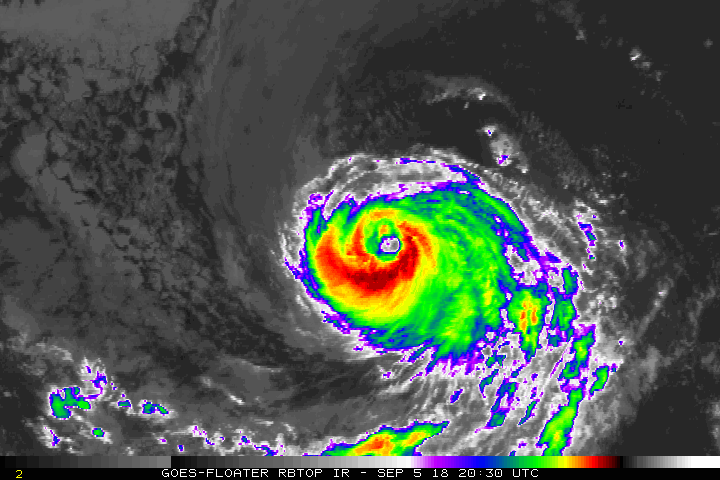
Am definitely not so confident it's continuing the weakening trend, kinda confirmed by no decrease at the latest advisory. Not super cold tops but symmetrical and seemingly healthy with an even better looking eye; looks a lot better than it did earlier today, actually. Fwiw, has risen a bit to a 5.4. The SST gradient east of Hawaii has always seemed a lil weird to me.
1 likes
Colors of lost purpose on the canvas of irrelevance
Not a meteorologist, in fact more of an idiot than anything. You should probably check with the NHC or a local NWS office for official information.
Not a meteorologist, in fact more of an idiot than anything. You should probably check with the NHC or a local NWS office for official information.


Re: EPAC: OLIVIA - Hurricane
Much more symmetrical now. Looks like a major again to me.
2 likes
The above post and any post by Ntxw is NOT an official forecast and should not be used as such. It is just the opinion of the poster and may or may not be backed by sound meteorological data. It is NOT endorsed by any professional institution including Storm2k. For official information, please refer to NWS products.
Help support Storm2K!

Re: EPAC: OLIVIA - Hurricane
Lots of talk about Florence and the mainland. Olivia maybe has other plans for Hawaii. Still a long way out though beyond 5 days. A hit from the East or Northeast is a lot tougher than from the south. This would be the 4th Hurricane to come within vicinity/nearby of Hawaii this season alone. (Hector, Lane, Norman)
1 likes
The above post and any post by Ntxw is NOT an official forecast and should not be used as such. It is just the opinion of the poster and may or may not be backed by sound meteorological data. It is NOT endorsed by any professional institution including Storm2k. For official information, please refer to NWS products.
Help support Storm2K!
Help support Storm2K!
-
Kingarabian

- S2K Supporter

- Posts: 16365
- Joined: Sat Aug 08, 2009 3:06 am
- Location: Honolulu, Hawaii
Re: EPAC: OLIVIA - Hurricane
Ntxw wrote:Lots of talk about Florence and the mainland. Olivia maybe has other plans for Hawaii. Still a long way out though beyond 5 days. A hit from the East or Northeast is a lot tougher than from the south. This would be the 4th Hurricane to come within vicinity/nearby of Hawaii this season alone. (Hector, Lane, Norman)
[img]https://images2.imgbox.com/48/4d/je0JAN8C_o.gif[/mg]
Yup, this thread will become active in due time.
0 likes
RIP Kobe Bryant
-
Kingarabian
- S2K Supporter
- Posts: 16365
- Joined: Sat Aug 08, 2009 3:06 am
- Location: Honolulu, Hawaii
Re: EPAC: OLIVIA - Hurricane
ADT CI is back up to 5.4, closing in on 5.5. Supports a major hurricane classification.
1 likes
RIP Kobe Bryant
Re: EPAC: OLIVIA - Hurricane
Kingarabian wrote:ADT CI is back up to 5.4, closing in on 5.5. Supports a major hurricane classification.
What are the odds it loses banding and goes annular with a big eye? Cooler SSTs and drier environment would be interesting if she can.
0 likes
The above post and any post by Ntxw is NOT an official forecast and should not be used as such. It is just the opinion of the poster and may or may not be backed by sound meteorological data. It is NOT endorsed by any professional institution including Storm2k. For official information, please refer to NWS products.
Help support Storm2K!
Help support Storm2K!
-
Hurricaneman

- Category 5
- Posts: 7404
- Age: 45
- Joined: Tue Aug 31, 2004 3:24 pm
- Location: central florida
Re: EPAC: OLIVIA - Hurricane
Ntxw wrote:Kingarabian wrote:ADT CI is back up to 5.4, closing in on 5.5. Supports a major hurricane classification.
What are the odds it loses banding and goes annular with a big eye?
Not sure this will go annular but could be a threat to Hawaii
0 likes
-
EquusStorm
- Category 5
- Posts: 1649
- Age: 35
- Joined: Thu Nov 07, 2013 1:04 pm
- Location: Jasper, AL
- Contact:
Re: EPAC: OLIVIA - Hurricane
Yeah this has clearly significantly recovered from being a low-end C2. I kinda doubt they'd do a special update to change anything before the next advisory cycle, being in the Epac and a week from affecting Hawaii, but I'm going to go to bed confident this is a 3 again for sure.
2 likes
Colors of lost purpose on the canvas of irrelevance
Not a meteorologist, in fact more of an idiot than anything. You should probably check with the NHC or a local NWS office for official information.
Not a meteorologist, in fact more of an idiot than anything. You should probably check with the NHC or a local NWS office for official information.
-
Kingarabian
- S2K Supporter
- Posts: 16365
- Joined: Sat Aug 08, 2009 3:06 am
- Location: Honolulu, Hawaii
Re: EPAC: OLIVIA - Hurricane
Ntxw wrote:Kingarabian wrote:ADT CI is back up to 5.4, closing in on 5.5. Supports a major hurricane classification.
What are the odds it loses banding and goes annular with a big eye? Cooler SSTs and drier environment would be interesting if she can.
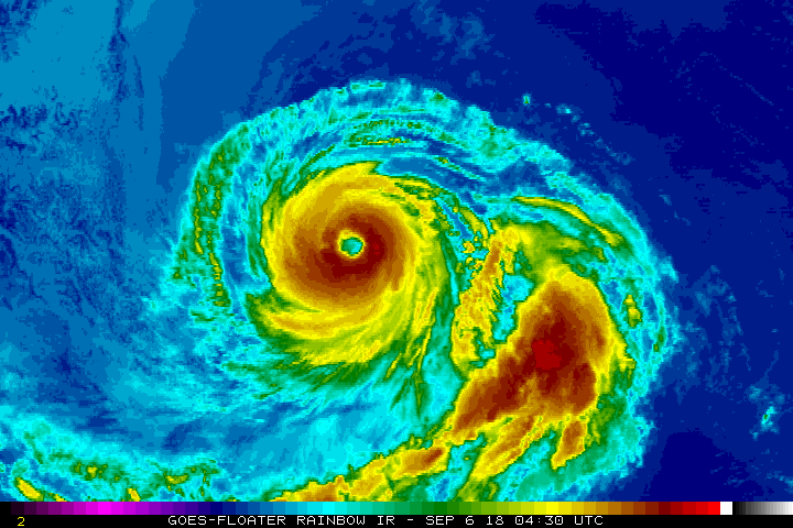
[img]https://images2.imgbox.com/05/ba/5uPaljot_o.jpg[/mg]
Will need to be closely monitored in case it becomes annular. Olivia becoming annular within the next 48 hours could be a worst case scenario in case it takes one of the modeled out tracks.
I would say theres a good chance it becomes annular if it loses that sprawling band to the S/SE. It seems as soon as these EPAC systems hit dry air and loiter around the present SST gradient, they shrink and become annular.
A hurricane transitioning and becoming annular is so hard to predict. If it wasn't for that large feeder band that it developed within the last few hours, it's current structure would certainly fit the bill.
Last edited by Kingarabian on Thu Sep 06, 2018 12:25 am, edited 1 time in total.
0 likes
RIP Kobe Bryant
-
Yellow Evan

- Professional-Met

- Posts: 16240
- Age: 27
- Joined: Fri Jul 15, 2011 12:48 pm
- Location: Henderson, Nevada/Honolulu, HI
- Contact:
Re: EPAC: OLIVIA - Hurricane
Classic EPAC re-intensification going on as we’ve seen this play out several times this seaso. Likely to sustain a similar intensity until shear kicks in.
2 likes
-
EquusStorm
- Category 5
- Posts: 1649
- Age: 35
- Joined: Thu Nov 07, 2013 1:04 pm
- Location: Jasper, AL
- Contact:
Re: EPAC: OLIVIA - Hurricane
The moment the EPac leaves the spotlight with Florence and Gordon developing, it starts to show off to garner attention again. And it's quite a show, honestly. The weakening flag is quite understandably off now with Olivia's ADT; easily 95kt (and probably 100kt) at the next advisory.
1 likes
Colors of lost purpose on the canvas of irrelevance
Not a meteorologist, in fact more of an idiot than anything. You should probably check with the NHC or a local NWS office for official information.
Not a meteorologist, in fact more of an idiot than anything. You should probably check with the NHC or a local NWS office for official information.

Re: EPAC: OLIVIA - Hurricane
I imagine it must be really frustrating to be a specialist at the NHC this season. All these storms just want to defy forecasts.
Next spring they should put in a request to retire all the names used this season citing "extreme forecasting frustration."
Just like, listen, we never want to work with a storm with one of these names ever again.
Next spring they should put in a request to retire all the names used this season citing "extreme forecasting frustration."
Just like, listen, we never want to work with a storm with one of these names ever again.
1 likes
Solar Aquarian
Lunar Cancerian
 Sagittarian
Lunar Cancerian
-
Yellow Evan
- Professional-Met
- Posts: 16240
- Age: 27
- Joined: Fri Jul 15, 2011 12:48 pm
- Location: Henderson, Nevada/Honolulu, HI
- Contact:
-
1900hurricane

- Category 5
- Posts: 6063
- Age: 34
- Joined: Fri Feb 06, 2015 12:04 pm
- Location: Houston, TX
- Contact:
Re: EPAC: OLIVIA - Hurricane
SATCON is running a little higher than the operational estimates, about 95 kt.

1 likes
Contract Meteorologist. TAMU & MSST. Fiercely authentic, one of a kind. We are all given free will, so choose a life meant to be lived. We are the Masters of our own Stories.
Opinions expressed are mine alone.
Follow me on Twitter at @1900hurricane : Read blogs at https://1900hurricane.wordpress.com/
Opinions expressed are mine alone.
Follow me on Twitter at @1900hurricane : Read blogs at https://1900hurricane.wordpress.com/
-
Kingarabian
- S2K Supporter
- Posts: 16365
- Joined: Sat Aug 08, 2009 3:06 am
- Location: Honolulu, Hawaii

-
Kingarabian
- S2K Supporter
- Posts: 16365
- Joined: Sat Aug 08, 2009 3:06 am
- Location: Honolulu, Hawaii
Re: EPAC: OLIVIA - Hurricane
bob rulz wrote:It certainly looks to be on a strengthening trend tonight.
Yes, still intensifying no doubt:

Hope the NHC ignores that SAB estimate.
0 likes
RIP Kobe Bryant
-
Kingarabian
- S2K Supporter
- Posts: 16365
- Joined: Sat Aug 08, 2009 3:06 am
- Location: Honolulu, Hawaii
Re: EPAC: OLIVIA - Hurricane
UW - CIMSS
ADVANCED DVORAK TECHNIQUE
ADT-Version 9.0
Tropical Cyclone Intensity Algorithm
----- Current Analysis -----
Date : 06 SEP 2018 Time : 073000 UTC
Lat : 17:59:23 N Lon : 125:33:00 W
CI# /Pressure/ Vmax
5.4 / 959.1mb/ 99.6kt
Final T# Adj T# Raw T#
5.4 5.7 5.7
ADVANCED DVORAK TECHNIQUE
ADT-Version 9.0
Tropical Cyclone Intensity Algorithm
----- Current Analysis -----
Date : 06 SEP 2018 Time : 073000 UTC
Lat : 17:59:23 N Lon : 125:33:00 W
CI# /Pressure/ Vmax
5.4 / 959.1mb/ 99.6kt
Final T# Adj T# Raw T#
5.4 5.7 5.7
0 likes
RIP Kobe Bryant
-
Kingarabian
- S2K Supporter
- Posts: 16365
- Joined: Sat Aug 08, 2009 3:06 am
- Location: Honolulu, Hawaii
Re: EPAC: OLIVIA - Hurricane
Hurricane Olivia Discussion Number 22
NWS National Hurricane Center Miami FL EP172018
200 AM PDT Thu Sep 06 2018
The cloud tops surrounding Olivia's 25 n mi diameter eye have cooled
somewhat over the past several hours, indicative of a little
strengthening. The initial intensity is increased to 90 kt, which
is a blend of lower subjective Dvorak estimates and higher objective
SATCON and ADT estimates. Olivia will soon be moving over somewhat
cooler SSTs and into a drier mid-level air mass. This should lead
to gradual weakening over the next few days. The official intensity
forecast is very close to the simple and corrected intensity
consensus models, IVCN and HCCA. Olivia has a fairly large eye
with limited banding features, but the numerical guidance indicates
a low likelihood that the system could become an annular hurricane.
Nonetheless, if that transition were to occur, Olivia would likely
maintain a higher intensity for the next few days than indicated
here.
No significant changes have been made to the NHC track prediction
or forecast reasoning. Olivia continues moving west-northwestward
or 285/12 kt. A well-defined deep-layer ridge should remain in
place to the north of the hurricane for the next several days, and
this ridge is expected to build westward during the forecast
period. As a result, Olivia should gradually turn from its
west-northwestward heading to a westward course by the weekend.
The track guidance models remain in excellent agreement on this
scenario. The official forecast is close to the dynamical model
consensus and the latest ECMWF prediction. This is essentially an
update of the previous NHC track.
FORECAST POSITIONS AND MAX WINDS
INIT 06/0900Z 18.1N 125.8W 90 KT 105 MPH
12H 06/1800Z 18.5N 127.7W 90 KT 105 MPH
24H 07/0600Z 19.4N 130.3W 85 KT 100 MPH
36H 07/1800Z 20.2N 132.9W 75 KT 85 MPH
48H 08/0600Z 21.0N 135.5W 70 KT 80 MPH
72H 09/0600Z 21.7N 140.7W 60 KT 70 MPH
96H 10/0600Z 22.0N 145.5W 60 KT 70 MPH
120H 11/0600Z 22.0N 149.5W 60 KT 70 MPH
$$
Forecaster Pasch
0 likes
RIP Kobe Bryant
-
EquusStorm
- Category 5
- Posts: 1649
- Age: 35
- Joined: Thu Nov 07, 2013 1:04 pm
- Location: Jasper, AL
- Contact:
Re: EPAC: OLIVIA - Hurricane
Uh... yeah. If this is just 90kt (lower than the two other rather ragged looking hurricanes active, neither of which has a clear open eye) then I'm the prince of some random eastern European country and I expect an apology and a more reasonable intensity estimate by 11am Eastern. But what do I know
0 likes
Colors of lost purpose on the canvas of irrelevance
Not a meteorologist, in fact more of an idiot than anything. You should probably check with the NHC or a local NWS office for official information.
Not a meteorologist, in fact more of an idiot than anything. You should probably check with the NHC or a local NWS office for official information.
Who is online
Users browsing this forum: No registered users and 63 guests