WPAC: MANGKHUT - Post-Tropical

Moderator: S2k Moderators

Message
Author
ejeraldmc
Tropical Storm
Tropical Storm
Posts: 121
Joined: Thu Oct 14, 2010 6:27 pm
Location: Batangas

Re: WPAC: MANGKHUT - Typhoon

#641 Postby ejeraldmc » Fri Sep 14, 2018 9:15 am

euro6208 wrote:BT was at 145 knots but this is strengthening rapidly. Look at how warm the eye is and the ever expanding cloud tops. I'd give this 160 or higher. What a monster.

https://i.imgur.com/YFAyRzV.gif
https://i.imgur.com/Ln4TDuT.gif


Cold dark grey ring developing just before landfall
0 likes   
The above post is not official and should not be used as such. It is the opinion of the poster and may or may not be backed by sound meteorological data. It is not endorsed by any professional institution or storm2k.org. For official information, please refer to the NHC and NWS products.

User avatar
Highteeld
Category 5
Category 5
Posts: 2139
Age: 41
Joined: Tue Jan 30, 2018 9:10 pm
Location: Chicago

Re: WPAC: MANGKHUT - Typhoon

#642 Postby Highteeld » Fri Sep 14, 2018 9:17 am

Image
Looks like a full CMG ring to me
0 likes   
Very useful information on the Dvorak Technique --

https://severe.worldweather.wmo.int/TCF ... kBeven.pdf

Stratosphere747
Category 5
Category 5
Posts: 3772
Joined: Thu Sep 11, 2003 8:34 pm
Location: Surfside Beach/Freeport Tx
Contact:

Re: WPAC: MANGKHUT - Typhoon

#643 Postby Stratosphere747 » Fri Sep 14, 2018 9:23 am

For those that have knowledge of the area

I'm helping Josh navigate into position and need a little info. Needless to say time is of the essence.

I found the spot for him at Magapit bridge but he might need to adjust further to the N and E.

Any idea if gonzaga is viable? Thinking I've found a spot there at the town hall but can't find much into about other structures. Has to be a concrete building...

Thx in advance

Scott

Either pm or reply here.
0 likes   

User avatar
xtyphooncyclonex
Category 5
Category 5
Posts: 3861
Age: 23
Joined: Sat Dec 08, 2012 9:07 am
Location: Cebu City
Contact:

Re: WPAC: MANGKHUT - Typhoon

#644 Postby xtyphooncyclonex » Fri Sep 14, 2018 9:32 am

Not looking good for Cagayan. This is no Haima. It's strengthening once again

Image
0 likes   
REMINDER: My opinions that I, or any other NON Pro-Met in this forum, are unofficial. Please do not take my opinions as an official forecast and warning. I am NOT a meteorologist. Following my forecasts blindly may lead to false alarm, danger and risk if official forecasts from agencies are ignored.

User avatar
mrbagyo
Category 5
Category 5
Posts: 3715
Age: 33
Joined: Thu Apr 12, 2012 9:18 am
Location: 14.13N 120.98E
Contact:

Re: WPAC: MANGKHUT - Typhoon

#645 Postby mrbagyo » Fri Sep 14, 2018 9:36 am

I'd give that 155 knots easy

Radar
Image
0 likes   
The posts in this forum are NOT official forecast and should not be used as such. They are just the opinion of the poster and may or may not be backed by sound meteorological data. They are NOT endorsed by any professional institution or storm2k.org. For official information, please refer to RSMC, NHC and NWS products.

tatlopuyo
Tropical Low
Tropical Low
Posts: 24
Joined: Sat Aug 26, 2017 8:53 pm

Re: WPAC: MANGKHUT - Typhoon

#646 Postby tatlopuyo » Fri Sep 14, 2018 9:40 am

The way this is moving right now. Is it possible that it will just hit the tip of northern luzon? And if that will be the case this wont weaken right since it will still be moving through waters or land interaction will disrupt it?
0 likes   

User avatar
doomhaMwx
Category 5
Category 5
Posts: 2454
Age: 26
Joined: Tue Apr 18, 2017 4:01 am
Location: Baguio/Benguet, Philippines
Contact:

Re: WPAC: MANGKHUT - Typhoon

#647 Postby doomhaMwx » Fri Sep 14, 2018 9:41 am

Oh boy...

Image
0 likes   

User avatar
Highteeld
Category 5
Category 5
Posts: 2139
Age: 41
Joined: Tue Jan 30, 2018 9:10 pm
Location: Chicago

Re: WPAC: MANGKHUT - Typhoon

#648 Postby Highteeld » Fri Sep 14, 2018 9:44 am

Image
0 likes   
Very useful information on the Dvorak Technique --

https://severe.worldweather.wmo.int/TCF ... kBeven.pdf

User avatar
mrbagyo
Category 5
Category 5
Posts: 3715
Age: 33
Joined: Thu Apr 12, 2012 9:18 am
Location: 14.13N 120.98E
Contact:

Re: WPAC: MANGKHUT - Typhoon

#649 Postby mrbagyo » Fri Sep 14, 2018 9:56 am

Stratosphere747 wrote:For those that have knowledge of the area

I'm helping Josh navigate into position and need a little info. Needless to say time is of the essence.

I found the spot for him at Magapit bridge but he might need to adjust further to the N and E.

Any idea if gonzaga is viable? Thinking I've found a spot there at the town hall but can't find much into about other structures. Has to be a concrete building...

Thx in advance

Scott

Either pm or reply here.


Been there before during Lawin / Haima. It's a small town but I don't know if it has a hotel. Best bet is the municipal hall.
0 likes   
The posts in this forum are NOT official forecast and should not be used as such. They are just the opinion of the poster and may or may not be backed by sound meteorological data. They are NOT endorsed by any professional institution or storm2k.org. For official information, please refer to RSMC, NHC and NWS products.

Stratosphere747
Category 5
Category 5
Posts: 3772
Joined: Thu Sep 11, 2003 8:34 pm
Location: Surfside Beach/Freeport Tx
Contact:

Re: WPAC: MANGKHUT - Typhoon

#650 Postby Stratosphere747 » Fri Sep 14, 2018 10:03 am

mrbagyo wrote:
Stratosphere747 wrote:For those that have knowledge of the area

I'm helping Josh navigate into position and need a little info. Needless to say time is of the essence.

I found the spot for him at Magapit bridge but he might need to adjust further to the N and E.

Any idea if gonzaga is viable? Thinking I've found a spot there at the town hall but can't find much into about other structures. Has to be a concrete building...

Thx in advance

Scott

Either pm or reply here.


Been there before during Lawin / Haima. It's a small town but I don't know if it has a hotel. Best bet is the municipal hall.


We're trying to get in touch with the municipal hall right now.

How long of a drive is it and do you know the conditions of the road?
0 likes   

dexterlabio
Category 5
Category 5
Posts: 3468
Joined: Sat Oct 24, 2009 11:50 pm

Re: WPAC: MANGKHUT - Typhoon

#651 Postby dexterlabio » Fri Sep 14, 2018 10:04 am

tatlopuyo wrote:The way this is moving right now. Is it possible that it will just hit the tip of northern luzon? And if that will be the case this wont weaken right since it will still be moving through waters or land interaction will disrupt it?


Last few frames seem to signal the westward turn right into Cagayan. Either way, just grazing the coastline will be enough to disrupt the eyewall, no matter how ridiculously intense Mangkhut is.
0 likes   
Personal Forecast Disclaimer:
The posts in this forum are NOT official forecast and should not be used as such. They are just the opinion of the poster and may or may not be backed by sound meteorological data. They are NOT endorsed by any professional institution or storm2k.org. For official information, please refer to the NHC and NWS products.

dexterlabio
Category 5
Category 5
Posts: 3468
Joined: Sat Oct 24, 2009 11:50 pm

Re: WPAC: MANGKHUT - Typhoon

#652 Postby dexterlabio » Fri Sep 14, 2018 10:07 am

I'm not sure but I believe this is the best appearance of Mangkhut ever since it became a Category 5 super typhoon two days ago.
0 likes   
Personal Forecast Disclaimer:
The posts in this forum are NOT official forecast and should not be used as such. They are just the opinion of the poster and may or may not be backed by sound meteorological data. They are NOT endorsed by any professional institution or storm2k.org. For official information, please refer to the NHC and NWS products.

tatlopuyo
Tropical Low
Tropical Low
Posts: 24
Joined: Sat Aug 26, 2017 8:53 pm

Re: WPAC: MANGKHUT - Typhoon

#653 Postby tatlopuyo » Fri Sep 14, 2018 10:08 am

dexterlabio wrote:
tatlopuyo wrote:The way this is moving right now. Is it possible that it will just hit the tip of northern luzon? And if that will be the case this wont weaken right since it will still be moving through waters or land interaction will disrupt it?


Last few frames seem to signal the westward turn right into Cagayan. Either way, just grazing the coastline will be enough to disrupt the eyewall, no matter how ridiculously intense Mangkhut is.


Ic. Another question.. Is the condition going to get worse in the ncr the next few hours? Or it will be just like this until it pass?
0 likes   

User avatar
mrbagyo
Category 5
Category 5
Posts: 3715
Age: 33
Joined: Thu Apr 12, 2012 9:18 am
Location: 14.13N 120.98E
Contact:

Re: WPAC: MANGKHUT - Typhoon

#654 Postby mrbagyo » Fri Sep 14, 2018 10:09 am

It's still about an hour drive
0 likes   
The posts in this forum are NOT official forecast and should not be used as such. They are just the opinion of the poster and may or may not be backed by sound meteorological data. They are NOT endorsed by any professional institution or storm2k.org. For official information, please refer to RSMC, NHC and NWS products.
User avatar
Highteeld
Category 5
Category 5
Posts: 2139
Age: 41
Joined: Tue Jan 30, 2018 9:10 pm
Location: Chicago

Re: WPAC: MANGKHUT - Typhoon

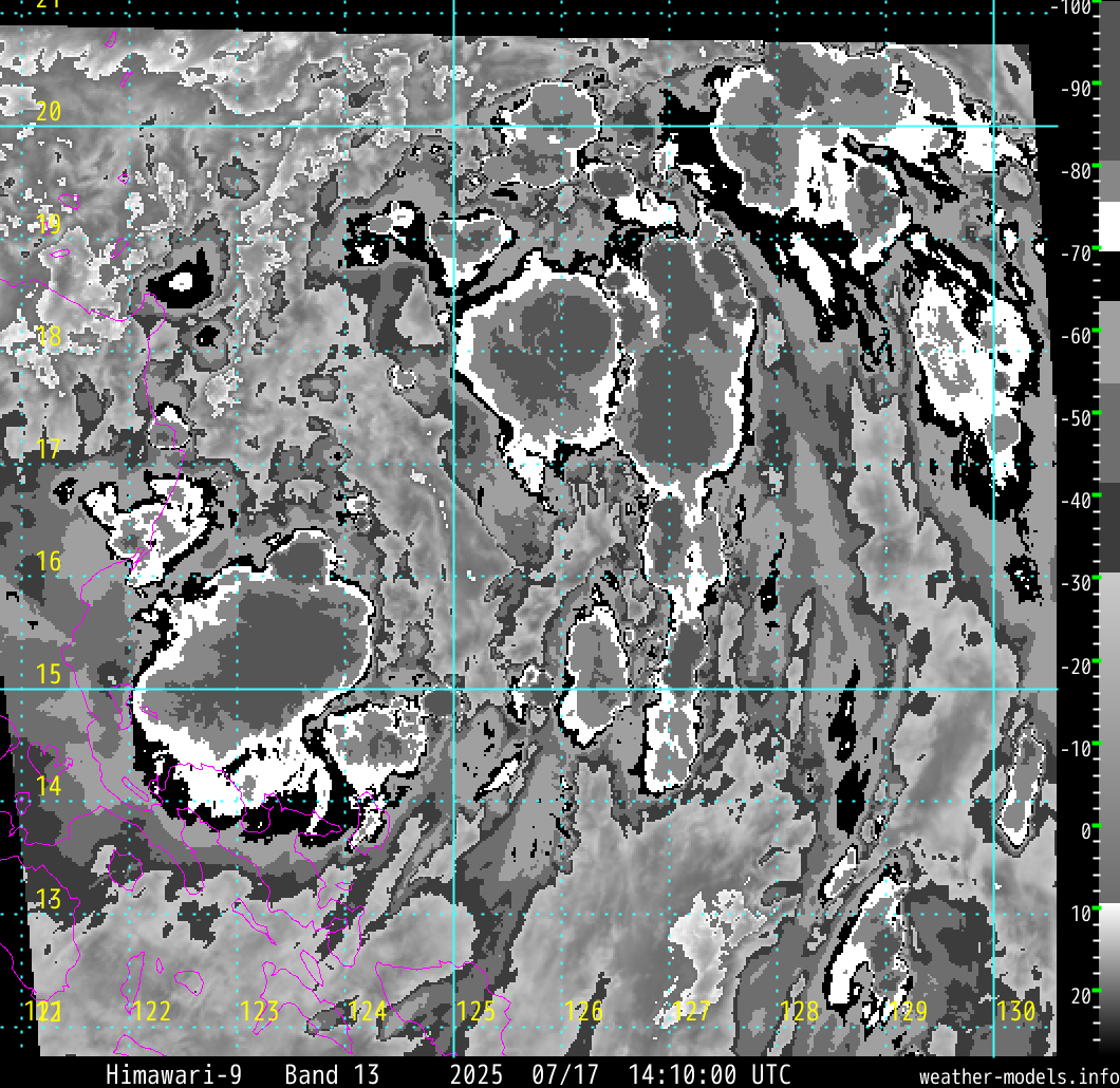
#655 Postby Highteeld » Fri Sep 14, 2018 10:11 am

Image


Definitely some last minute intensification there
1 likes   
Very useful information on the Dvorak Technique --

https://severe.worldweather.wmo.int/TCF ... kBeven.pdf

User avatar
xtyphooncyclonex
Category 5
Category 5
Posts: 3861
Age: 23
Joined: Sat Dec 08, 2012 9:07 am
Location: Cebu City
Contact:

Re: WPAC: MANGKHUT - Typhoon

#656 Postby xtyphooncyclonex » Fri Sep 14, 2018 10:13 am

Measured 91.7 km/h here in Cebu City
0 likes   
REMINDER: My opinions that I, or any other NON Pro-Met in this forum, are unofficial. Please do not take my opinions as an official forecast and warning. I am NOT a meteorologist. Following my forecasts blindly may lead to false alarm, danger and risk if official forecasts from agencies are ignored.

User avatar
Highteeld
Category 5
Category 5
Posts: 2139
Age: 41
Joined: Tue Jan 30, 2018 9:10 pm
Location: Chicago

Re: WPAC: MANGKHUT - Typhoon

#657 Postby Highteeld » Fri Sep 14, 2018 10:20 am

Image


This typhoon is exceptionally intense. WOW. Just WOW!!!
0 likes   
Very useful information on the Dvorak Technique --

https://severe.worldweather.wmo.int/TCF ... kBeven.pdf

Stratosphere747
Category 5
Category 5
Posts: 3772
Joined: Thu Sep 11, 2003 8:34 pm
Location: Surfside Beach/Freeport Tx
Contact:

Re: WPAC: MANGKHUT - Typhoon

#658 Postby Stratosphere747 » Fri Sep 14, 2018 10:22 am

mrbagyo wrote:It's still about an hour drive


Thanks. He got in contact with the muni hall.

Any idea on the conditions of the road?
0 likes   

User avatar
mrbagyo
Category 5
Category 5
Posts: 3715
Age: 33
Joined: Thu Apr 12, 2012 9:18 am
Location: 14.13N 120.98E
Contact:

Re: WPAC: MANGKHUT - Typhoon

#659 Postby mrbagyo » Fri Sep 14, 2018 10:24 am

Stratosphere747 wrote:
mrbagyo wrote:It's still about an hour drive


Thanks. He got in contact with the muni hall.

Any idea on the conditions of the road?


Sorry but I got no idea right now.
0 likes   
The posts in this forum are NOT official forecast and should not be used as such. They are just the opinion of the poster and may or may not be backed by sound meteorological data. They are NOT endorsed by any professional institution or storm2k.org. For official information, please refer to RSMC, NHC and NWS products.

User avatar
Highteeld
Category 5
Category 5
Posts: 2139
Age: 41
Joined: Tue Jan 30, 2018 9:10 pm
Location: Chicago

Re: WPAC: MANGKHUT - Typhoon

#660 Postby Highteeld » Fri Sep 14, 2018 10:26 am

Image
0 likes   
Very useful information on the Dvorak Technique --

https://severe.worldweather.wmo.int/TCF ... kBeven.pdf


Return to “2018”

Who is online

Users browsing this forum: No registered users and 1 guest