WPAC: HECTOR - Post-Tropical
Moderator: S2k Moderators
-
Blown Away

- S2K Supporter

- Posts: 10253
- Joined: Wed May 26, 2004 6:17 am
Re: EPAC: HECTOR - Hurricane
King, can you post these models runs you are tracking closely?
0 likes
Hurricane Eye Experience: David 79, Irene 99, Frances 04, Jeanne 04, Wilma 05… Hurricane Brush Experience: Andrew 92, Erin 95, Floyd 99, Matthew 16, Irma 17, Ian 22, Nicole 22…
-
Kingarabian

- S2K Supporter
- Posts: 16365
- Joined: Sat Aug 08, 2009 3:06 am
- Location: Honolulu, Hawaii
Re: EPAC: HECTOR - Hurricane
Blown Away wrote:King, can you post these models runs you are tracking closely?
Here's the 18z GFS being compared to the past 3 runs:

0 likes
RIP Kobe Bryant
-
cycloneye

- Admin

- Posts: 149503
- Age: 69
- Joined: Thu Oct 10, 2002 10:54 am
- Location: San Juan, Puerto Rico
Re: EPAC: HECTOR - Hurricane
We have the major!!
EP, 10, 2018080400, , BEST, 0, 142N, 1303W, 100, 967, HU
6 likes
Visit the Caribbean-Central America Weather Thread where you can find at first post web cams,radars
and observations from Caribbean basin members Click Here
and observations from Caribbean basin members Click Here
-
TheAustinMan

- Category 5

- Posts: 1060
- Joined: Mon Jul 08, 2013 4:26 pm
- Location: Central TX / United States
Re: EPAC: HECTOR - Hurricane: 00z Best Track at 100 kts
In times like these where slight alterations in the forecast track have large implications in terms of impacts, especially for a meridionally narrow region of interest like the main Hawaiian island chain, it may be more useful to keep tabs on the ensemble spreads rather than looking at the main model runs cycle-to-cycle. These are better at capturing possible changes in how models handle variability in steering and give a more complete picture as to the range of possibilities for tropical cyclone tracks. Keep an eye on the less chaotic run-to-run trends seen in ensemble guidance. From what I've seen, the GEFS at least has recently been modeling a stronger mid-level ridge north of Hawaii in around five days.
8 likes
Treat my opinions with a grain of salt. For official information see your local weather service.
“It's tough to make predictions, especially about the future.”
“It's tough to make predictions, especially about the future.”
-
TheAustinMan
- Category 5
- Posts: 1060
- Joined: Mon Jul 08, 2013 4:26 pm
- Location: Central TX / United States
Re: EPAC: HECTOR - Hurricane
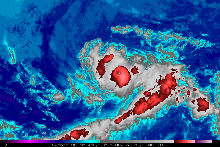
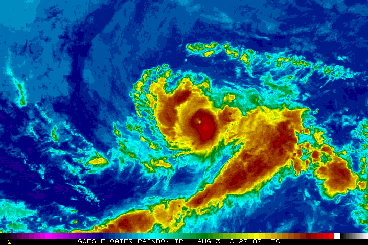
You might be able to pick out a small moat denoting the region between the inner and outer eyewalls as the ongoing eyewall replacement cycle takes place in this afternoon satellite photo from 01:15 UTC. Hector is a rather compact and well-organized system and the stadium-effect eye really accentuates the storm's appearance and intensity. If I had to guess, I'd put the intensity right now at 110 kts (though officially it is currently 90 kt with a tentative best track intensity of 100kt). For those doing their own satellite analyses, I'd suggest sticking with GOES-WEST/15 at this point as it looks like Hector is west enough where GOES-16 data is not particularly useful due to poor viewing angle and limb cooling. The cloud tops are warmer on GOES-WEST but the eye is sampled a lot more clearly.
556 KB. Source: Visible and infrared data originally from GOES MSFC, combined into the traditional RGB scheme using a photo editor

556 KB. Source: Visible and infrared data originally from GOES MSFC, combined into the traditional RGB scheme using a photo editor
8 likes
Treat my opinions with a grain of salt. For official information see your local weather service.
“It's tough to make predictions, especially about the future.”
“It's tough to make predictions, especially about the future.”
-
cycloneye
- Admin
- Posts: 149503
- Age: 69
- Joined: Thu Oct 10, 2002 10:54 am
- Location: San Juan, Puerto Rico
Re: EPAC: HECTOR - Hurricane
2 likes
Visit the Caribbean-Central America Weather Thread where you can find at first post web cams,radars
and observations from Caribbean basin members Click Here
and observations from Caribbean basin members Click Here
-
cycloneye
- Admin
- Posts: 149503
- Age: 69
- Joined: Thu Oct 10, 2002 10:54 am
- Location: San Juan, Puerto Rico
Re: EPAC: HECTOR - Hurricane
Hurricane Hector Discussion Number 14
NWS National Hurricane Center Miami FL EP102018
800 PM PDT Fri Aug 03 2018
Hector has continued to quickly strengthen since the last advisory,
with the eye becoming more distinct and the cloud tops in the
eyewall cooling to near -80C. Satellite intensity estimates from
TAFB and SAB were 102 kt near 00Z, and given the increasing
organization since that time the initial intensity is increased to
105 kt.
The initial motion is now 275/10. There is again little change to
the track forecast philosophy, as a large subtropical ridge to the
north of the hurricane should steer Hector generally westward
during the forecast period. Due to a weakness in the ridge, the
hurricane is forecast to gain some latitude from 36-96 h. While the
guidance agrees with this scenario, there is a significant amount of
spread between the GFS and NAVGEM on the north side of the guidance
envelope and the UKMET and ECMWF on the south side. The consensus
models are in the center of the envelope, and the new forecast is
close to these in best agreement with the HCCA corrected consensus.
The new forecast is little changed from the previous track.
Recent satellite microwave data show that Hector is developing an
outer eyewall, which suggests the hurricane should undergo an
eyewall replacement cycle during the next day or so. This makes it
a little unclear how long the current intensification will last.
The intensity forecast will show a little more strengthening during
the next 12 hr followed by little change in strength through 36 h.
The HWRF, HMON, and COAMPS-TC models show a little more
intensification at 48-60 h, and the official forecast follows suit.
After that time, while Hector should remain in a light-shear,
warm-water environment, entrainment of drier air should lead to a
gradual weakening of the cyclone. Overall, the new intensity
forecast lies near the upper edge of the intensity guidance.
There is the potential for Hector to bring some impacts to portions
of the Hawaiian Islands by the middle of next week, but it is too
soon to specify the magnitude of the impacts or where they could
occur. This is a good time for everyone in the Hawaiian Islands to
ensure they have their hurricane plan in place. For additional
information on any potential local impacts from Hector in Hawaii,
please refer to products issued by the NWS Weather Forecast Office
in Honolulu at http://www.prh.noaa.gov/hnl.
FORECAST POSITIONS AND MAX WINDS
INIT 04/0300Z 14.2N 130.9W 105 KT 120 MPH
12H 04/1200Z 14.3N 132.4W 110 KT 125 MPH
24H 05/0000Z 14.2N 134.5W 110 KT 125 MPH
36H 05/1200Z 14.2N 136.6W 110 KT 125 MPH
48H 06/0000Z 14.5N 139.1W 115 KT 130 MPH
72H 07/0000Z 15.5N 144.5W 105 KT 120 MPH
96H 08/0000Z 16.5N 150.5W 90 KT 105 MPH
120H 09/0000Z 16.5N 156.0W 80 KT 90 MPH
$$
Forecaster Beven
1 likes
Visit the Caribbean-Central America Weather Thread where you can find at first post web cams,radars
and observations from Caribbean basin members Click Here
and observations from Caribbean basin members Click Here
-
xtyphooncyclonex

- Category 5
- Posts: 3891
- Age: 24
- Joined: Sat Dec 08, 2012 9:07 am
- Location: Cebu City
- Contact:
Re: EPAC: HECTOR - Hurricane
My gut tells me there's this scenario of becoming a category 5........ in the West Pacific. What if this follows Oliwa, but peaks stronger in the East/Central Pacific and even more after crossing? Probably, this would be cat 4 at most in the EPac, there's even more potential in the WPac
0 likes
REMINDER: My opinions that I, or any other NON Pro-Met in this forum, are unofficial. Please do not take my opinions as an official forecast and warning. I am NOT a meteorologist. Following my forecasts blindly may lead to false alarm, danger and risk if official forecasts from agencies are ignored.
-
1900hurricane

- Category 5
- Posts: 6063
- Age: 34
- Joined: Fri Feb 06, 2015 12:04 pm
- Location: Houston, TX
- Contact:
Re: EPAC: HECTOR - Hurricane
Eyewall replacement seems to be progressing fairly seamlessly.

3 likes
Contract Meteorologist. TAMU & MSST. Fiercely authentic, one of a kind. We are all given free will, so choose a life meant to be lived. We are the Masters of our own Stories.
Opinions expressed are mine alone.
Follow me on Twitter at @1900hurricane : Read blogs at https://1900hurricane.wordpress.com/
Opinions expressed are mine alone.
Follow me on Twitter at @1900hurricane : Read blogs at https://1900hurricane.wordpress.com/
-
Twisted-core
Re: EPAC: HECTOR - Hurricane
If steered by upper levels 2-7 this system will likely be decapitated by the big island mountain.
0 likes
-
CrazyC83
- Professional-Met

- Posts: 34315
- Joined: Tue Mar 07, 2006 11:57 pm
- Location: Deep South, for the first time!
Re: EPAC: HECTOR - Hurricane
Interesting they added a message in the discussion, but didn't use the Key Messages format.
3 likes
-
Yellow Evan

- Professional-Met
- Posts: 16240
- Age: 27
- Joined: Fri Jul 15, 2011 12:48 pm
- Location: Henderson, Nevada/Honolulu, HI
- Contact:
Re: EPAC: HECTOR - Hurricane

T6.5 near T7.0. I'd say this is getting close to Cat 5 if it wasn't about to ERC.
3 likes
-
Kingarabian
- S2K Supporter
- Posts: 16365
- Joined: Sat Aug 08, 2009 3:06 am
- Location: Honolulu, Hawaii
Re: EPAC: HECTOR - Hurricane: 00z Best Track at 100 kts
TheAustinMan wrote:In times like these where slight alterations in the forecast track have large implications in terms of impacts, especially for a meridionally narrow region of interest like the main Hawaiian island chain, it may be more useful to keep tabs on the ensemble spreads rather than looking at the main model runs cycle-to-cycle. These are better at capturing possible changes in how models handle variability in steering and give a more complete picture as to the range of possibilities for tropical cyclone tracks. Keep an eye on the less chaotic run-to-run trends seen in ensemble guidance. From what I've seen, the GEFS at least has recently been modeling a stronger mid-level ridge north of Hawaii in around five days.
Agreed. Although the stronger ensembles take it further north.
0 likes
RIP Kobe Bryant
-
Kingarabian
- S2K Supporter
- Posts: 16365
- Joined: Sat Aug 08, 2009 3:06 am
- Location: Honolulu, Hawaii
Re: EPAC: HECTOR - Hurricane
Yellow Evan wrote:[img]https://i.imgur.com/lIEPBum.gif[/ig]
T6.5 near T7.0. I'd say this is getting close to Cat 5 if it wasn't about to ERC.
Sheesh
0 likes
RIP Kobe Bryant
-
xtyphooncyclonex
- Category 5
- Posts: 3891
- Age: 24
- Joined: Sat Dec 08, 2012 9:07 am
- Location: Cebu City
- Contact:
Re: EPAC: HECTOR - Hurricane
Oh boy, after seeing its structure and success after the ERC this could be much much stronger than forecast.
I'd say it would turn to the northwest, get close to Hawaii, weaken, then strengthen as it enters the West Pac. For some reason, I'm actually just as worried for Japan as I'm worried for Hawaii
I'd say it would turn to the northwest, get close to Hawaii, weaken, then strengthen as it enters the West Pac. For some reason, I'm actually just as worried for Japan as I'm worried for Hawaii
1 likes
REMINDER: My opinions that I, or any other NON Pro-Met in this forum, are unofficial. Please do not take my opinions as an official forecast and warning. I am NOT a meteorologist. Following my forecasts blindly may lead to false alarm, danger and risk if official forecasts from agencies are ignored.


Re: EPAC: HECTOR - Hurricane
Stunning system. Easily a Cat 4 already. Very small, circular eye.
7 likes
The above post and any post by Ntxw is NOT an official forecast and should not be used as such. It is just the opinion of the poster and may or may not be backed by sound meteorological data. It is NOT endorsed by any professional institution including Storm2k. For official information, please refer to NWS products.
Help support Storm2K!

Re: EPAC: HECTOR - Hurricane
If this undergoes EI, then perhaps the scenario of Maui or Oahu comes back into play
0 likes
-
Yellow Evan
- Professional-Met
- Posts: 16240
- Age: 27
- Joined: Fri Jul 15, 2011 12:48 pm
- Location: Henderson, Nevada/Honolulu, HI
- Contact:
Re: EPAC: HECTOR - Hurricane
Kingarabian wrote:Yellow Evan wrote:[img]https://i.imgur.com/lIEPBum.gif[/ig]
T6.5 near T7.0. I'd say this is getting close to Cat 5 if it wasn't about to ERC.
Sheesh
Take back what I said eye was WMG like I thought it was for some reason.
0 likes
Re: EPAC: HECTOR - Hurricane
not strong enough on the gfs initialization. It also has significant weakening tomorrow for unknown reasons
1 likes
Re: EPAC: HECTOR - Hurricane

3 likes
The above post and any post by Ntxw is NOT an official forecast and should not be used as such. It is just the opinion of the poster and may or may not be backed by sound meteorological data. It is NOT endorsed by any professional institution including Storm2k. For official information, please refer to NWS products.
Help support Storm2K!
Help support Storm2K!
Who is online
Users browsing this forum: No registered users and 48 guests