
CPAC: OLIVIA - Post-Tropical
Moderator: S2k Moderators
-
1900hurricane

- Category 5

- Posts: 6063
- Age: 34
- Joined: Fri Feb 06, 2015 12:04 pm
- Location: Houston, TX
- Contact:
Re: EPAC: OLIVIA - Hurricane
Instantaneous DT is up to 6.0.
1 likes
Contract Meteorologist. TAMU & MSST. Fiercely authentic, one of a kind. We are all given free will, so choose a life meant to be lived. We are the Masters of our own Stories.
Opinions expressed are mine alone.
Follow me on Twitter at @1900hurricane : Read blogs at https://1900hurricane.wordpress.com/
Opinions expressed are mine alone.
Follow me on Twitter at @1900hurricane : Read blogs at https://1900hurricane.wordpress.com/
-
Kingarabian

- S2K Supporter

- Posts: 16365
- Joined: Sat Aug 08, 2009 3:06 am
- Location: Honolulu, Hawaii
Re: EPAC: OLIVIA - Hurricane
1900hurricane wrote:Instantaneous DT is up to 6.0.
[img]http://rammb.cira.colostate.edu/products/tc_realtime/products/storms/2018EP17/4KMSRBDC/2018EP17_4KMSRBDC_201809060845.jpg[img]
White ring slowly filling in. Hard to say with a certainty due to the unfavorable thermodynamics but it could be making a 3rd attempt at Cat.4.
0 likes
RIP Kobe Bryant
-
cycloneye

- Admin

- Posts: 149493
- Age: 69
- Joined: Thu Oct 10, 2002 10:54 am
- Location: San Juan, Puerto Rico
Re: EPAC: OLIVIA - Hurricane
Special Advisory
Hurricane Olivia Special Discussion Number 23
NWS National Hurricane Center Miami FL EP172018
500 AM PDT Thu Sep 06 2018
Olivia has continued to intensify during the past several hours and
has re-gained major hurricane status. This special advisory is
being issued to increase the initial intensity to 105 kt and to
increase the intensity during the first 72 h of the forecast.
There is no change to the track forecast or the later portions of
the intensity forecast.
FORECAST POSITIONS AND MAX WINDS
INIT 06/1200Z 18.2N 126.5W 105 KT 120 MPH
12H 06/1800Z 18.5N 127.7W 110 KT 125 MPH
24H 07/0600Z 19.4N 130.3W 100 KT 115 MPH
36H 07/1800Z 20.2N 132.9W 85 KT 100 MPH
48H 08/0600Z 21.0N 135.5W 75 KT 85 MPH
72H 09/0600Z 21.7N 140.7W 60 KT 70 MPH
96H 10/0600Z 22.0N 145.5W 60 KT 70 MPH
120H 11/0600Z 22.0N 149.5W 60 KT 70 MPH
$$
Forecaster Beven
0 likes
Visit the Caribbean-Central America Weather Thread where you can find at first post web cams,radars
and observations from Caribbean basin members Click Here
and observations from Caribbean basin members Click Here
-
tolakram
- Admin
- Posts: 20186
- Age: 62
- Joined: Sun Aug 27, 2006 8:23 pm
- Location: Florence, KY (name is Mark)
Re: EPAC: OLIVIA - Hurricane
0 likes
M a r k
- - - - -
Join us in chat: Storm2K Chatroom Invite. Android and IOS apps also available.
The posts in this forum are NOT official forecasts and should not be used as such. Posts are NOT endorsed by any professional institution or STORM2K.org. For official information and forecasts, please refer to NHC and NWS products.


Re: EPAC: OLIVIA - Hurricane
Eye has been cooling but clouds cooling also. Almost W ring. If she can put it together maybe run for 120kts?
0 likes
The above post and any post by Ntxw is NOT an official forecast and should not be used as such. It is just the opinion of the poster and may or may not be backed by sound meteorological data. It is NOT endorsed by any professional institution including Storm2k. For official information, please refer to NWS products.
Help support Storm2K!

-
cycloneye
- Admin
- Posts: 149493
- Age: 69
- Joined: Thu Oct 10, 2002 10:54 am
- Location: San Juan, Puerto Rico
Re: EPAC: OLIVIA - Hurricane
Hurricane Olivia Discussion Number 24
NWS National Hurricane Center Miami FL EP172018
800 AM PDT Thu Sep 06 2018
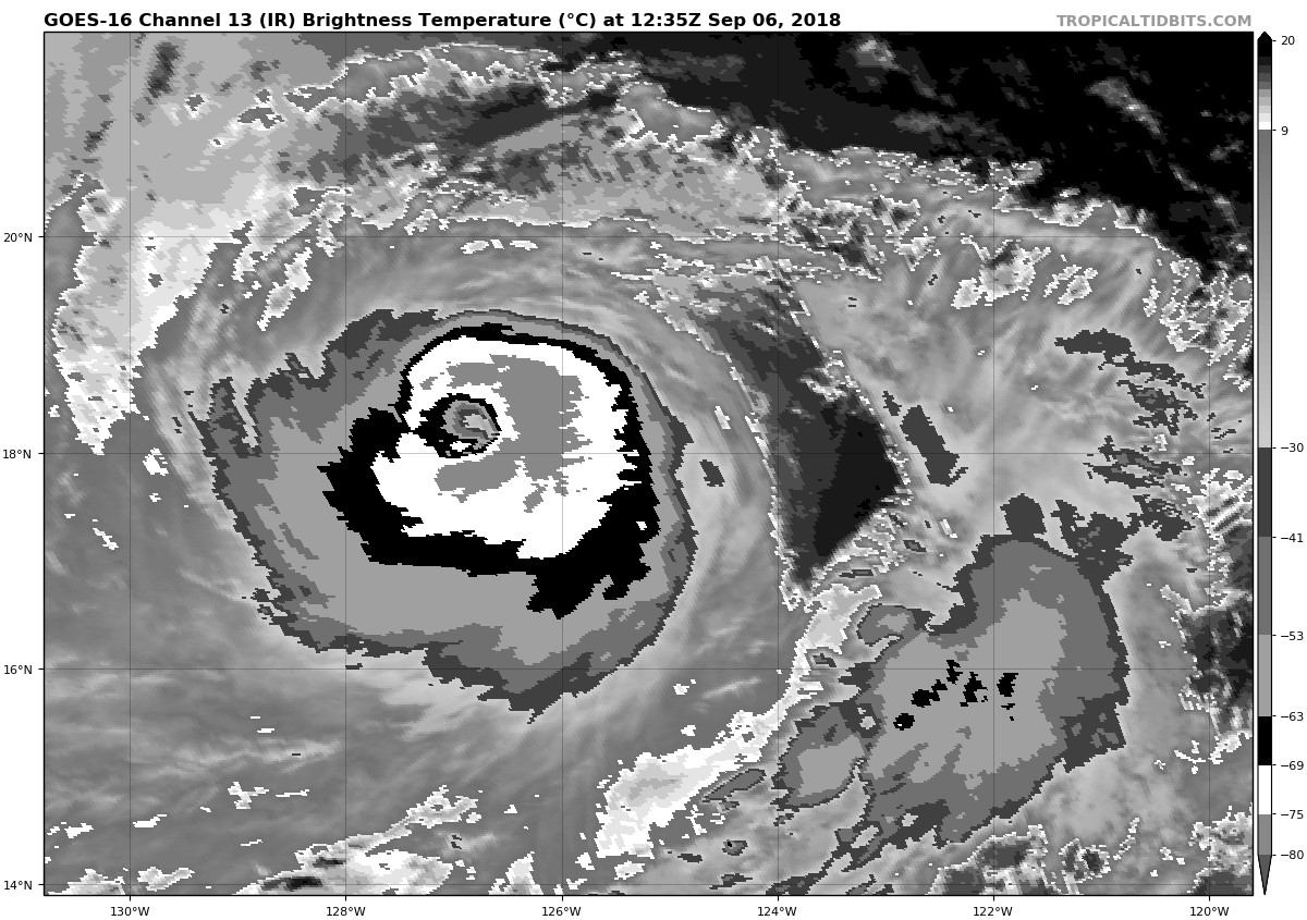
Satellite imagery indicates that Olivia has a well-defined 20 n mi
wide eye, although the eye is not quite as distinct as it was at
the time of the previous special advisory. The eye is inside of a
central dense overcast with eyewall cloud tops as cold as -80C.
Satellite intensity estimates are currently in the 100-115 kt
range. Based on these, the initial intensity is set at 105 kt, and
it is possible that this is a little conservative. The hurricane
is now in a light vertical shear environment and is showing good
cirrus outflow in the southwestern semicircle.
The intensity guidance has been consistent in saying that Olivia
should weaken due to a combination of decreasing sea surface
temperatures along the forecast track and entrainment of dry air.
The hurricane has not yet followed the guidance, and the current
structure and convective trends suggest that this round of
intensification may not be finished. After 12 h, Olivia should move
north of the 26C isotherm, and the cyclone should mostly traverse
sea-surface temperatures of 25-26C for the remainder of the forecast
period. This development should start a weakening trend. The new
intensity forecast allows for 12 h of additional strengthening,
followed by a gradual weakening that follows the overall trend of
the intensity guidance. However, the new forecast lies at the upper
edge of the guidance, and thus most of the forecast intensities are
higher than those in both the previous special and regular
advisories.
Water vapor imagery shows a large deep-layer ridge to the north of
Olivia, and the large-scale models forecast the western end of the
ridge to build westward during the next several days. This pattern
should steer the cyclone west-northwestward for the next 48 h or
so, followed by a westward motion from 72-120 h. The track guidance
is in good agreement with this scenario, and the guidance is more
tightly clustered than it was 24 h ago. The new forecast track is
similar to the previous track through 48 h, then it is nudged a
little to the south of the previous track from 72-120 h. The new
track lies close to the various consensus models.
FORECAST POSITIONS AND MAX WINDS
INIT 06/1500Z 18.4N 127.2W 105 KT 120 MPH
12H 07/0000Z 18.9N 129.2W 110 KT 125 MPH
24H 07/1200Z 19.8N 131.8W 100 KT 115 MPH
36H 08/0000Z 20.5N 134.4W 90 KT 105 MPH
48H 08/1200Z 21.2N 137.0W 80 KT 90 MPH
72H 09/1200Z 21.5N 142.0W 70 KT 80 MPH
96H 10/1200Z 21.5N 146.5W 65 KT 75 MPH
120H 11/1200Z 21.5N 150.5W 60 KT 70 MPH
$$
Forecaster Beven
NWS National Hurricane Center Miami FL EP172018
800 AM PDT Thu Sep 06 2018
Satellite imagery indicates that Olivia has a well-defined 20 n mi
wide eye, although the eye is not quite as distinct as it was at
the time of the previous special advisory. The eye is inside of a
central dense overcast with eyewall cloud tops as cold as -80C.
Satellite intensity estimates are currently in the 100-115 kt
range. Based on these, the initial intensity is set at 105 kt, and
it is possible that this is a little conservative. The hurricane
is now in a light vertical shear environment and is showing good
cirrus outflow in the southwestern semicircle.
The intensity guidance has been consistent in saying that Olivia
should weaken due to a combination of decreasing sea surface
temperatures along the forecast track and entrainment of dry air.
The hurricane has not yet followed the guidance, and the current
structure and convective trends suggest that this round of
intensification may not be finished. After 12 h, Olivia should move
north of the 26C isotherm, and the cyclone should mostly traverse
sea-surface temperatures of 25-26C for the remainder of the forecast
period. This development should start a weakening trend. The new
intensity forecast allows for 12 h of additional strengthening,
followed by a gradual weakening that follows the overall trend of
the intensity guidance. However, the new forecast lies at the upper
edge of the guidance, and thus most of the forecast intensities are
higher than those in both the previous special and regular
advisories.
Water vapor imagery shows a large deep-layer ridge to the north of
Olivia, and the large-scale models forecast the western end of the
ridge to build westward during the next several days. This pattern
should steer the cyclone west-northwestward for the next 48 h or
so, followed by a westward motion from 72-120 h. The track guidance
is in good agreement with this scenario, and the guidance is more
tightly clustered than it was 24 h ago. The new forecast track is
similar to the previous track through 48 h, then it is nudged a
little to the south of the previous track from 72-120 h. The new
track lies close to the various consensus models.
FORECAST POSITIONS AND MAX WINDS
INIT 06/1500Z 18.4N 127.2W 105 KT 120 MPH
12H 07/0000Z 18.9N 129.2W 110 KT 125 MPH
24H 07/1200Z 19.8N 131.8W 100 KT 115 MPH
36H 08/0000Z 20.5N 134.4W 90 KT 105 MPH
48H 08/1200Z 21.2N 137.0W 80 KT 90 MPH
72H 09/1200Z 21.5N 142.0W 70 KT 80 MPH
96H 10/1200Z 21.5N 146.5W 65 KT 75 MPH
120H 11/1200Z 21.5N 150.5W 60 KT 70 MPH
$$
Forecaster Beven
0 likes
Visit the Caribbean-Central America Weather Thread where you can find at first post web cams,radars
and observations from Caribbean basin members Click Here
and observations from Caribbean basin members Click Here
Re: EPAC: OLIVIA - Hurricane
105kts seems very conservative to me
1 likes
The above post and any post by Ntxw is NOT an official forecast and should not be used as such. It is just the opinion of the poster and may or may not be backed by sound meteorological data. It is NOT endorsed by any professional institution including Storm2k. For official information, please refer to NWS products.
Help support Storm2K!
Help support Storm2K!

-
EquusStorm
- Category 5
- Posts: 1649
- Age: 35
- Joined: Thu Nov 07, 2013 1:04 pm
- Location: Jasper, AL
- Contact:
Re: EPAC: OLIVIA - Hurricane
So it may finally hit cat 4, but in its second wind. Fascinating.
Told'ya 90kt was a bad estimate at 5am :p
Told'ya 90kt was a bad estimate at 5am :p
1 likes
Colors of lost purpose on the canvas of irrelevance
Not a meteorologist, in fact more of an idiot than anything. You should probably check with the NHC or a local NWS office for official information.
Not a meteorologist, in fact more of an idiot than anything. You should probably check with the NHC or a local NWS office for official information.
-
Yellow Evan

- Professional-Met

- Posts: 16240
- Age: 27
- Joined: Fri Jul 15, 2011 12:48 pm
- Location: Henderson, Nevada/Honolulu, HI
- Contact:

Re: EPAC: OLIVIA - Hurricane
EquusStorm wrote:So it may finally hit cat 4, but in its second wind. Fascinating.
Told'ya 90kt was a bad estimate at 5am :p
This has been the story for several EPAC+CPAC crossers this season. On Monday the forecast for today was for a weakening storm around 80kts due to shear and cooler SSTs. There have been some underachievers but also overachievers.
2 likes
The above post and any post by Ntxw is NOT an official forecast and should not be used as such. It is just the opinion of the poster and may or may not be backed by sound meteorological data. It is NOT endorsed by any professional institution including Storm2k. For official information, please refer to NWS products.
Help support Storm2K!
Help support Storm2K!
-
1900hurricane
- Category 5
- Posts: 6063
- Age: 34
- Joined: Fri Feb 06, 2015 12:04 pm
- Location: Houston, TX
- Contact:
Re: EPAC: OLIVIA - Hurricane
I'd argue for a 110 kt intensity estimate at 12Z based largely on the 112 kt SATCON intensity estimate at the same time. Based on improved satellite presentation, I don't think it's a stretch to think that Olivia is now a category 4.
1 likes
Contract Meteorologist. TAMU & MSST. Fiercely authentic, one of a kind. We are all given free will, so choose a life meant to be lived. We are the Masters of our own Stories.
Opinions expressed are mine alone.
Follow me on Twitter at @1900hurricane : Read blogs at https://1900hurricane.wordpress.com/
Opinions expressed are mine alone.
Follow me on Twitter at @1900hurricane : Read blogs at https://1900hurricane.wordpress.com/
-
tolakram
- Admin
- Posts: 20186
- Age: 62
- Joined: Sun Aug 27, 2006 8:23 pm
- Location: Florence, KY (name is Mark)
Re: EPAC: OLIVIA - Hurricane
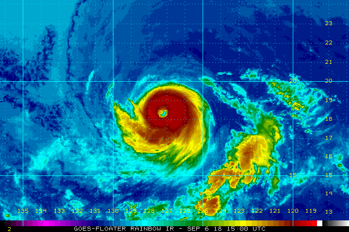
Losing some banding, perhaps? I won't use the overused a word. 
slider image

source: http://rammb-slider.cira.colostate.edu/?sat=goes-17&sec=full_disk&x=3742&y=6910&z=4&im=12&ts=1&st=0&et=0&speed=130&motion=loop&map=1&lat=0&p%5B0%5D=1&opacity%5B0%5D=1&hidden%5B0%5D=0&pause=0&slider=-1&hide_controls=0&mouse_draw=0&s=rammb-slider
slider image
source: http://rammb-slider.cira.colostate.edu/?sat=goes-17&sec=full_disk&x=3742&y=6910&z=4&im=12&ts=1&st=0&et=0&speed=130&motion=loop&map=1&lat=0&p%5B0%5D=1&opacity%5B0%5D=1&hidden%5B0%5D=0&pause=0&slider=-1&hide_controls=0&mouse_draw=0&s=rammb-slider
1 likes
M a r k
- - - - -
Join us in chat: Storm2K Chatroom Invite. Android and IOS apps also available.
The posts in this forum are NOT official forecasts and should not be used as such. Posts are NOT endorsed by any professional institution or STORM2K.org. For official information and forecasts, please refer to NHC and NWS products.
- - - - -
Join us in chat: Storm2K Chatroom Invite. Android and IOS apps also available.
The posts in this forum are NOT official forecasts and should not be used as such. Posts are NOT endorsed by any professional institution or STORM2K.org. For official information and forecasts, please refer to NHC and NWS products.
-
Kingarabian
- S2K Supporter
- Posts: 16365
- Joined: Sat Aug 08, 2009 3:06 am
- Location: Honolulu, Hawaii
Re: EPAC: OLIVIA - Hurricane
tolakram wrote:Losing some banding, perhaps? I won't use the overused a word.
slider image
[img]https://i.imgur.com/3v5YprD.png[img]
source: http://rammb-slider.cira.colostate.edu/?sat=goes-17&sec=full_disk&x=3742&y=6910&z=4&im=12&ts=1&st=0&et=0&speed=130&motion=loop&map=1&lat=0&p%5B0%5D=1&opacity%5B0%5D=1&hidden%5B0%5D=0&pause=0&slider=-1&hide_controls=0&mouse_draw=0&s=rammb-slider
Thanks for the link!
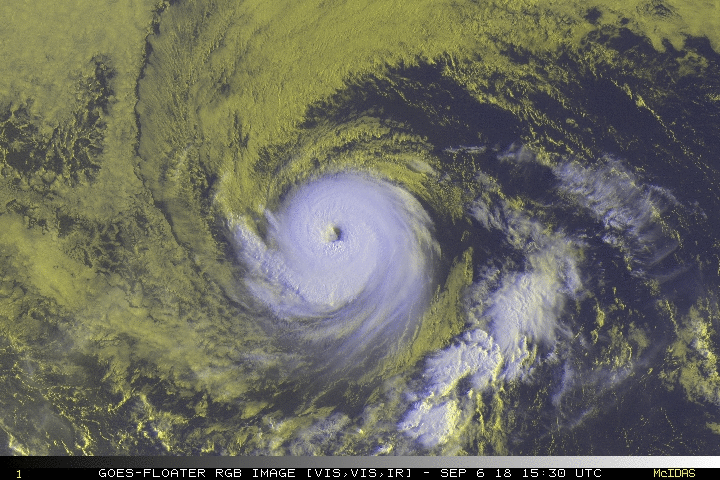
In the meanwhile it looks like Olivia is leveling off, but still a major hurricane:

2 likes
RIP Kobe Bryant
-
supercane4867
- Category 5
- Posts: 4966
- Joined: Wed Nov 14, 2012 10:43 am
Re: EPAC: OLIVIA - Hurricane
## ANNULAR HURRICANE INDEX (AHI) EP172018 OLIVIA 09/06/18 18 UTC ##
## PASSED SCREENING STEP, MIGHT BE ANNULAR, CALCULATE AHI FROM DISCRIMINANT ANALYSIS ##
## AHI= 78 (AHI OF 100 IS BEST FIT TO ANN. STRUC., 1 IS MARGINAL, 0 IS NOT ANNULAR) ##
## PASSED SCREENING STEP, MIGHT BE ANNULAR, CALCULATE AHI FROM DISCRIMINANT ANALYSIS ##
## AHI= 78 (AHI OF 100 IS BEST FIT TO ANN. STRUC., 1 IS MARGINAL, 0 IS NOT ANNULAR) ##
1 likes
-
Kingarabian
- S2K Supporter
- Posts: 16365
- Joined: Sat Aug 08, 2009 3:06 am
- Location: Honolulu, Hawaii
Re: EPAC: OLIVIA - Hurricane
For a potential Hawaii threat, the 12z model suite had much more spread.
12z GFS had a big shift away to keep this west of Hawaii due to a weaker ridge, thus little impacts to the state:

12z FV3-GFS has a 1000mb TS landfall on the Big Island:

12z Euro has a 999mb landfall on Oahu:

12z UKMET is east of the Big Island:

12z CMC is much closer to the islands and has a Kauai landfall:

12z GFS had a big shift away to keep this west of Hawaii due to a weaker ridge, thus little impacts to the state:
12z FV3-GFS has a 1000mb TS landfall on the Big Island:
12z Euro has a 999mb landfall on Oahu:
12z UKMET is east of the Big Island:
12z CMC is much closer to the islands and has a Kauai landfall:
0 likes
RIP Kobe Bryant
-
Kingarabian
- S2K Supporter
- Posts: 16365
- Joined: Sat Aug 08, 2009 3:06 am
- Location: Honolulu, Hawaii
Re: EPAC: OLIVIA - Hurricane
12z UK-ENS have become tightly clustered, unfortunately over the wrong spots.

0 likes
RIP Kobe Bryant
-
Kingarabian
- S2K Supporter
- Posts: 16365
- Joined: Sat Aug 08, 2009 3:06 am
- Location: Honolulu, Hawaii
EPAC: OLIVIA - Recon
887
NOUS42 KNHC 061715
REPRPD
WEATHER RECONNAISSANCE FLIGHTS
CARCAH, NATIONAL HURRICANE CENTER, MIAMI, FL.
0115 PM EDT THU 06 SEPTEMBER 2018
SUBJECT: TROPICAL CYCLONE PLAN OF THE DAY (TCPOD)
VALID 07/1100Z TO 08/1100Z SEPTEMBER 2018
TCPOD NUMBER.....18-105
II. PACIFIC REQUIREMENTS
1. NEGATIVE RECONNAISSANCE REQUIREMENTS.
2. SUCCEEDING DAY OUTLOOK: POSSIBLE USAF RESERVE C-130 SYNOPTIC
SURVEILLANCE MISSION AROUND HURRICANE OLIVIA FOR 09/0000Z.
3. ADDITIONAL DAY OUTLOOK: BEGIN 12-HRLY FIXES ON HURRICANE
OLIVIA AT 09/1800Z.
$$
SEF
0 likes
RIP Kobe Bryant
-
Kingarabian
- S2K Supporter
- Posts: 16365
- Joined: Sat Aug 08, 2009 3:06 am
- Location: Honolulu, Hawaii
Re: EPAC: OLIVIA - Recon
Think they've seen enough model runs and are going to go ahead with 12 hours fixes on Sunday.
The synoptic mission will probably be on hold depending on the threat level.
The synoptic mission will probably be on hold depending on the threat level.
0 likes
RIP Kobe Bryant
-
Kingarabian
- S2K Supporter
- Posts: 16365
- Joined: Sat Aug 08, 2009 3:06 am
- Location: Honolulu, Hawaii
Re: EPAC: OLIVIA - Hurricane
Hurricane Olivia Discussion Number 25
NWS National Hurricane Center Miami FL EP172018
200 PM PDT Thu Sep 06 2018
Olivia has continued to strengthen since the previous advisory,
with the eye becoming better defined inside of the central dense
overcast. The various satellite intensity estimates range from
100-120 kt, and the initial intensity is nudged upward to 110 kt in
agreement with the CIMSS satellite consensus. The hurricane
remains in a light vertical shear environment and is showing good
cirrus outflow, especially in the southwestern semicircle.
Olivia should remain in a light shear environment during the
forecast period, so sea surface temperatures and environmental
moisture should be the main controls on the intensity. The
hurricane should reach the 26C sea surface temperature isotherm in
about 12 h, and this should finally cause the hurricane to weaken.
The forecast track keeps the cyclone over 25-26C sea surface
temperatures through about the 72 h point as it also encounters a
drier airmass, and thus the intensity forecast shows weakening
consistent with the trend of the intensity guidance. After 72 h,
the waters along the forecast track begin to warm, but the airmass
near Olivia gets even drier. The guidance shows continued weakening
during this time, so the intensity forecast follows suit. However,
there is lower confidence in this portion of the forecast.
Water vapor imagery continues to show a large deep-layer ridge to
the north of Olivia, and the large-scale models forecast the western
end of the ridge to build westward during the next several days.
This pattern should steer the cyclone west-northwestward for the
next 48 h or so, followed by a westward motion from 72-120 h. The
tightly clustered track guidance supports this scenario, and the
new forecast track is changed little from the previous forecast.
FORECAST POSITIONS AND MAX WINDS
INIT 06/2100Z 18.6N 128.5W 110 KT 125 MPH
12H 07/0600Z 19.2N 130.5W 110 KT 125 MPH
24H 07/1800Z 20.0N 133.0W 100 KT 115 MPH
36H 08/0600Z 20.7N 135.6W 90 KT 105 MPH
48H 08/1800Z 21.2N 138.2W 80 KT 90 MPH
72H 09/1800Z 21.5N 143.5W 70 KT 80 MPH
96H 10/1800Z 21.5N 147.5W 65 KT 75 MPH
120H 11/1800Z 21.5N 151.5W 60 KT 70 MPH
$$
Forecaster Beven
0 likes
RIP Kobe Bryant
Who is online
Users browsing this forum: No registered users and 69 guests