* EAST PACIFIC 2018 SHIPS INTENSITY FORECAST *
* IR SAT DATA AVAILABLE, OHC AVAILABLE *
* NORMAN EP162018 08/30/18 12 UTC *
TIME (HR) 0 6 12 18 24 36 48 60 72 84 96 108 120
V (KT) NO LAND 125 140 142 138 133 117 102 90 85 80 69 57 50
V (KT) LAND 125 140 142 138 133 117 102 90 85 80 69 57 50
V (KT) LGEM 125 138 140 135 127 114 104 94 84 76 68 61 56
Storm Type TROP TROP TROP TROP TROP TROP TROP TROP TROP TROP TROP TROP TROP
SHEAR (KT) 8 11 17 15 16 18 21 18 15 14 14 4 4
SHEAR ADJ (KT) -1 -2 -4 -5 -3 1 0 1 4 6 4 2 -1
SHEAR DIR 68 88 102 93 67 60 53 67 107 98 111 122 183
SST (C) 29.4 29.3 29.1 28.9 28.8 28.6 28.4 28.2 28.0 27.5 26.9 26.7 26.3
POT. INT. (KT) 157 157 155 153 152 150 148 146 145 141 134 132 128
200 MB T (C) -52.5 -52.3 -52.0 -52.5 -52.3 -51.6 -51.8 -51.5 -52.0 -51.6 -52.2 -51.9 -52.2
200 MB VXT (C) 0.2 0.3 0.5 0.7 0.7 0.7 0.8 0.6 0.6 0.6 0.9 0.6 1.0
TH_E DEV (C) 6 5 6 5 5 5 6 6 5 5 5 5 5
700-500 MB RH 69 67 65 62 62 64 66 67 67 61 55 52 52
MODEL VTX (KT) 23 25 23 25 27 27 30 30 31 31 30 27 26
850 MB ENV VOR 39 49 52 52 53 78 92 103 112 106 102 97 88
200 MB DIV 55 77 42 -7 9 24 37 56 48 25 -13 11 -6
700-850 TADV -1 0 0 1 1 0 -3 -3 -3 -4 -3 2 0
LAND (KM) 952 1006 1064 1142 1221 1390 1578 1736 1843 1973 2145 1959 1695
LAT (DEG N) 17.8 17.8 17.7 17.5 17.2 16.5 15.9 15.9 16.4 17.3 18.5 19.5 20.2
LONG(DEG W) 117.6 118.4 119.2 120.0 120.8 122.3 124.1 126.0 128.0 130.5 133.4 136.1 138.6
STM SPEED (KT) 7 8 8 8 8 8 9 9 12 14 14 13 13
HEAT CONTENT 11 12 14 19 19 14 20 22 20 12 0 2 0
FORECAST TRACK FROM OFCI INITIAL HEADING/SPEED (DEG/KT):270/ 6 CX,CY: -5/ 0
T-12 MAX WIND: 70 PRESSURE OF STEERING LEVEL (MB): 541 (MEAN=584)
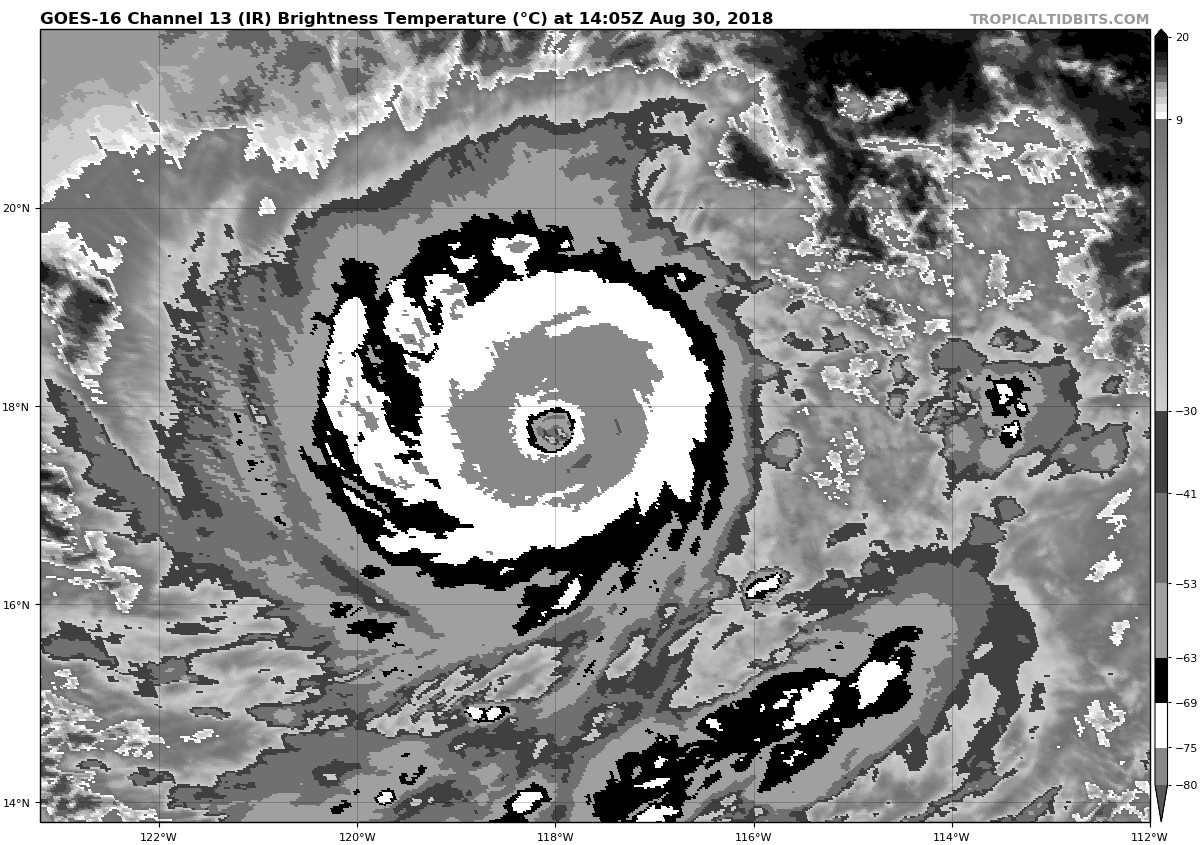
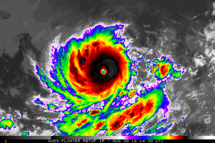
GOES IR BRIGHTNESS TEMP. STD DEV. 50-200 KM RAD: 3.7 (MEAN=14.5)
% GOES IR PIXELS WITH T < -20 C 50-200 KM RAD: 99.0 (MEAN=65.0)
PRELIM RI PROB (DV .GE. 55 KT IN 48 HR): 0.0
INDIVIDUAL CONTRIBUTIONS TO INTENSITY CHANGE
6 12 18 24 36 48 60 72 84 96 108 120
----------------------------------------------------------
SAMPLE MEAN CHANGE 0. 0. 1. 1. 1. 1. 1. 0. -1. -1. -2. -3.
SST POTENTIAL -1. -2. -3. -5. -11. -20. -30. -40. -47. -53. -56. -58.
VERTICAL SHEAR MAG -2. -5. -8. -10. -14. -16. -13. -7. -2. 0. 0. -1.
VERTICAL SHEAR ADJ 0. 0. 0. 0. 0. 0. 0. 0. 0. 0. 0. 1.
VERTICAL SHEAR DIR 0. 0. 1. 1. 2. 4. 5. 6. 6. 6. 5. 4.
PERSISTENCE 16. 21. 20. 17. 10. 3. -3. -8. -11. -15. -19. -19.
200/250 MB TEMP. 0. 0. 0. 0. 0. -1. 0. 0. 0. 0. 0. 0.
THETA_E EXCESS 0. 0. 0. -1. -1. -1. -1. -2. -2. -2. -3. -3.
700-500 MB RH 0. 0. 0. 0. 0. 0. 1. 1. 1. 1. 0. 0.
MODEL VTX TENDENCY 1. 0. 1. 4. 4. 7. 8. 11. 11. 9. 5. 3.
850 MB ENV VORTICITY 0. 0. 0. 0. 0. -1. -1. -2. -3. -3. -3. -4.
200 MB DIVERGENCE 0. 0. 0. 0. 0. 0. 0. 0. 0. -1. -1. -1.
850-700 T ADVEC 0. 0. 0. 0. 0. 0. 0. 0. 0. 0. 0. 0.
ZONAL STORM MOTION 0. 0. 0. 0. 0. -1. -1. -1. -1. -1. -1. -1.
STEERING LEVEL PRES 0. 0. 0. 0. 0. 0. 0. 0. 0. -1. -1. -1.
DAYS FROM CLIM. PEAK 0. 0. 0. 0. 0. 0. 1. 1. 2. 2. 2. 2.
GOES PREDICTORS 1. 2. 3. 3. 4. 4. 3. 3. 2. 2. 2. 2.
OCEAN HEAT CONTENT 0. 0. 0. 0. 0. 0. 0. 0. 0. 0. 0. 0.
RI POTENTIAL 0. 0. -1. -1. -2. -3. -3. -2. 0. 1. 2. 3.
----------------------------------------------------------
TOTAL CHANGE 15. 17. 13. 8. -8. -23. -35. -40. -45. -56. -68. -75.
CURRENT MAX WIND (KT): 125. LAT, LON: 17.8 117.6
** 2018 E. Pacific RI INDEX EP162018 NORMAN 08/30/18 12 UTC **
(SHIPS-RII PREDICTOR TABLE for 30 KT OR MORE MAXIMUM WIND INCREASE IN NEXT 24-h)
Predictor Value RI Predictor Range Scaled Value(0-1) % Contribution
POT = MPI-VMAX (KT) : 29.8 40.5 to 149.3 0.00 0.0
12 HR PERSISTENCE (KT) : 55.0 -22.0 to 44.0 1.00 999.0
850-200 MB SHEAR (KT) : 13.5 19.6 to 1.4 0.33 999.0
HEAT CONTENT (KJ/CM2) : 15.0 1.8 to 106.7 0.13 999.0
D200 (10**7s-1) : 35.2 -33.0 to 156.2 0.36 999.0
STD DEV OF IR BR TEMP : 3.7 37.8 to 2.1 0.96 999.0
MAXIMUM WIND (KT) : 125.0 22.5 to 132.0 0.09 999.0
BL DRY-AIR FLUX (W/M2) : 593.6 721.6 to -82.5 0.16 999.0
%area of TPW <45 mm upshear : 0.0 62.3 to 0.0 1.00 999.0
2nd PC OF IR BR TEMP : -0.5 2.2 to -1.9 0.65 999.0
SHIPS Prob RI for 20kt/ 12hr RI threshold= 59% is 9.7 times climatological mean ( 6.1%)
SHIPS Prob RI for 25kt/ 24hr RI threshold= 22% is 1.7 times climatological mean (12.5%)
SHIPS Prob RI for 30kt/ 24hr RI threshold= 0% is 0.0 times climatological mean ( 8.4%)
SHIPS Prob RI for 35kt/ 24hr RI threshold= 0% is 0.0 times climatological mean ( 6.0%)
SHIPS Prob RI for 40kt/ 24hr RI threshold= 0% is 0.0 times climatological mean ( 4.0%)
SHIPS Prob RI for 45kt/ 36hr RI threshold= 0% is 0.0 times climatological mean ( 6.5%)
SHIPS Prob RI for 55kt/ 48hr RI threshold= 0% is 0.0 times climatological mean ( 5.9%)
SHIPS Prob RI for 65kt/ 72hr RI threshold= 0% is 0.0 times climatological mean ( 4.8%)
Matrix of RI probabilities
------------------------------------------------------------------------------
RI (kt / h) | 20/12 | 25/24 | 30/24 | 35/24 | 40/24 | 45/36 | 55/48 |65/72
------------------------------------------------------------------------------
SHIPS-RII: 59.1% 21.7% 0.0% 0.0% 0.0% 0.0% 0.0% 0.0%
Logistic: 63.9% 17.3% 18.3% 19.0% 26.7% 4.1% 2.1% 0.1%
Bayesian: 5.8% 0.0% 0.0% 0.0% 0.0% 0.0% 0.0% 0.0%
Consensus: 43.0% 13.0% 6.1% 6.3% 8.9% 1.4% 0.7% 0.0%
DTOPS: 17.0% 2.0% 0.0% 0.0% 0.0% 0.0% 0.0% 0.0%
## ANNULAR HURRICANE INDEX (AHI) EP162018 NORMAN 08/30/18 12 UTC ##
## PASSED SCREENING STEP, MIGHT BE ANNULAR, CALCULATE AHI FROM DISCRIMINANT ANALYSIS ##
## AHI= 1 (AHI OF 100 IS BEST FIT TO ANN. STRUC., 1 IS MARGINAL, 0 IS NOT ANNULAR) ##
CONTRIBUTIONS TO ANNULAR INDEX
* IR SAT DATA AVAILABLE, OHC AVAILABLE *
* NORMAN EP162018 08/30/18 12 UTC *
TIME (HR) 0 6 12 18 24 36 48 60 72 84 96 108 120
V (KT) NO LAND 125 140 142 138 133 117 102 90 85 80 69 57 50
V (KT) LAND 125 140 142 138 133 117 102 90 85 80 69 57 50
V (KT) LGEM 125 138 140 135 127 114 104 94 84 76 68 61 56
Storm Type TROP TROP TROP TROP TROP TROP TROP TROP TROP TROP TROP TROP TROP
SHEAR (KT) 8 11 17 15 16 18 21 18 15 14 14 4 4
SHEAR ADJ (KT) -1 -2 -4 -5 -3 1 0 1 4 6 4 2 -1
SHEAR DIR 68 88 102 93 67 60 53 67 107 98 111 122 183
SST (C) 29.4 29.3 29.1 28.9 28.8 28.6 28.4 28.2 28.0 27.5 26.9 26.7 26.3
POT. INT. (KT) 157 157 155 153 152 150 148 146 145 141 134 132 128
200 MB T (C) -52.5 -52.3 -52.0 -52.5 -52.3 -51.6 -51.8 -51.5 -52.0 -51.6 -52.2 -51.9 -52.2
200 MB VXT (C) 0.2 0.3 0.5 0.7 0.7 0.7 0.8 0.6 0.6 0.6 0.9 0.6 1.0
TH_E DEV (C) 6 5 6 5 5 5 6 6 5 5 5 5 5
700-500 MB RH 69 67 65 62 62 64 66 67 67 61 55 52 52
MODEL VTX (KT) 23 25 23 25 27 27 30 30 31 31 30 27 26
850 MB ENV VOR 39 49 52 52 53 78 92 103 112 106 102 97 88
200 MB DIV 55 77 42 -7 9 24 37 56 48 25 -13 11 -6
700-850 TADV -1 0 0 1 1 0 -3 -3 -3 -4 -3 2 0
LAND (KM) 952 1006 1064 1142 1221 1390 1578 1736 1843 1973 2145 1959 1695
LAT (DEG N) 17.8 17.8 17.7 17.5 17.2 16.5 15.9 15.9 16.4 17.3 18.5 19.5 20.2
LONG(DEG W) 117.6 118.4 119.2 120.0 120.8 122.3 124.1 126.0 128.0 130.5 133.4 136.1 138.6
STM SPEED (KT) 7 8 8 8 8 8 9 9 12 14 14 13 13
HEAT CONTENT 11 12 14 19 19 14 20 22 20 12 0 2 0
FORECAST TRACK FROM OFCI INITIAL HEADING/SPEED (DEG/KT):270/ 6 CX,CY: -5/ 0
T-12 MAX WIND: 70 PRESSURE OF STEERING LEVEL (MB): 541 (MEAN=584)
GOES IR BRIGHTNESS TEMP. STD DEV. 50-200 KM RAD: 3.7 (MEAN=14.5)
% GOES IR PIXELS WITH T < -20 C 50-200 KM RAD: 99.0 (MEAN=65.0)
PRELIM RI PROB (DV .GE. 55 KT IN 48 HR): 0.0
INDIVIDUAL CONTRIBUTIONS TO INTENSITY CHANGE
6 12 18 24 36 48 60 72 84 96 108 120
----------------------------------------------------------
SAMPLE MEAN CHANGE 0. 0. 1. 1. 1. 1. 1. 0. -1. -1. -2. -3.
SST POTENTIAL -1. -2. -3. -5. -11. -20. -30. -40. -47. -53. -56. -58.
VERTICAL SHEAR MAG -2. -5. -8. -10. -14. -16. -13. -7. -2. 0. 0. -1.
VERTICAL SHEAR ADJ 0. 0. 0. 0. 0. 0. 0. 0. 0. 0. 0. 1.
VERTICAL SHEAR DIR 0. 0. 1. 1. 2. 4. 5. 6. 6. 6. 5. 4.
PERSISTENCE 16. 21. 20. 17. 10. 3. -3. -8. -11. -15. -19. -19.
200/250 MB TEMP. 0. 0. 0. 0. 0. -1. 0. 0. 0. 0. 0. 0.
THETA_E EXCESS 0. 0. 0. -1. -1. -1. -1. -2. -2. -2. -3. -3.
700-500 MB RH 0. 0. 0. 0. 0. 0. 1. 1. 1. 1. 0. 0.
MODEL VTX TENDENCY 1. 0. 1. 4. 4. 7. 8. 11. 11. 9. 5. 3.
850 MB ENV VORTICITY 0. 0. 0. 0. 0. -1. -1. -2. -3. -3. -3. -4.
200 MB DIVERGENCE 0. 0. 0. 0. 0. 0. 0. 0. 0. -1. -1. -1.
850-700 T ADVEC 0. 0. 0. 0. 0. 0. 0. 0. 0. 0. 0. 0.
ZONAL STORM MOTION 0. 0. 0. 0. 0. -1. -1. -1. -1. -1. -1. -1.
STEERING LEVEL PRES 0. 0. 0. 0. 0. 0. 0. 0. 0. -1. -1. -1.
DAYS FROM CLIM. PEAK 0. 0. 0. 0. 0. 0. 1. 1. 2. 2. 2. 2.
GOES PREDICTORS 1. 2. 3. 3. 4. 4. 3. 3. 2. 2. 2. 2.
OCEAN HEAT CONTENT 0. 0. 0. 0. 0. 0. 0. 0. 0. 0. 0. 0.
RI POTENTIAL 0. 0. -1. -1. -2. -3. -3. -2. 0. 1. 2. 3.
----------------------------------------------------------
TOTAL CHANGE 15. 17. 13. 8. -8. -23. -35. -40. -45. -56. -68. -75.
CURRENT MAX WIND (KT): 125. LAT, LON: 17.8 117.6
** 2018 E. Pacific RI INDEX EP162018 NORMAN 08/30/18 12 UTC **
(SHIPS-RII PREDICTOR TABLE for 30 KT OR MORE MAXIMUM WIND INCREASE IN NEXT 24-h)
Predictor Value RI Predictor Range Scaled Value(0-1) % Contribution
POT = MPI-VMAX (KT) : 29.8 40.5 to 149.3 0.00 0.0
12 HR PERSISTENCE (KT) : 55.0 -22.0 to 44.0 1.00 999.0
850-200 MB SHEAR (KT) : 13.5 19.6 to 1.4 0.33 999.0
HEAT CONTENT (KJ/CM2) : 15.0 1.8 to 106.7 0.13 999.0
D200 (10**7s-1) : 35.2 -33.0 to 156.2 0.36 999.0
STD DEV OF IR BR TEMP : 3.7 37.8 to 2.1 0.96 999.0
MAXIMUM WIND (KT) : 125.0 22.5 to 132.0 0.09 999.0
BL DRY-AIR FLUX (W/M2) : 593.6 721.6 to -82.5 0.16 999.0
%area of TPW <45 mm upshear : 0.0 62.3 to 0.0 1.00 999.0
2nd PC OF IR BR TEMP : -0.5 2.2 to -1.9 0.65 999.0
SHIPS Prob RI for 20kt/ 12hr RI threshold= 59% is 9.7 times climatological mean ( 6.1%)
SHIPS Prob RI for 25kt/ 24hr RI threshold= 22% is 1.7 times climatological mean (12.5%)
SHIPS Prob RI for 30kt/ 24hr RI threshold= 0% is 0.0 times climatological mean ( 8.4%)
SHIPS Prob RI for 35kt/ 24hr RI threshold= 0% is 0.0 times climatological mean ( 6.0%)
SHIPS Prob RI for 40kt/ 24hr RI threshold= 0% is 0.0 times climatological mean ( 4.0%)
SHIPS Prob RI for 45kt/ 36hr RI threshold= 0% is 0.0 times climatological mean ( 6.5%)
SHIPS Prob RI for 55kt/ 48hr RI threshold= 0% is 0.0 times climatological mean ( 5.9%)
SHIPS Prob RI for 65kt/ 72hr RI threshold= 0% is 0.0 times climatological mean ( 4.8%)
Matrix of RI probabilities
------------------------------------------------------------------------------
RI (kt / h) | 20/12 | 25/24 | 30/24 | 35/24 | 40/24 | 45/36 | 55/48 |65/72
------------------------------------------------------------------------------
SHIPS-RII: 59.1% 21.7% 0.0% 0.0% 0.0% 0.0% 0.0% 0.0%
Logistic: 63.9% 17.3% 18.3% 19.0% 26.7% 4.1% 2.1% 0.1%
Bayesian: 5.8% 0.0% 0.0% 0.0% 0.0% 0.0% 0.0% 0.0%
Consensus: 43.0% 13.0% 6.1% 6.3% 8.9% 1.4% 0.7% 0.0%
DTOPS: 17.0% 2.0% 0.0% 0.0% 0.0% 0.0% 0.0% 0.0%
## ANNULAR HURRICANE INDEX (AHI) EP162018 NORMAN 08/30/18 12 UTC ##
## PASSED SCREENING STEP, MIGHT BE ANNULAR, CALCULATE AHI FROM DISCRIMINANT ANALYSIS ##
## AHI= 1 (AHI OF 100 IS BEST FIT TO ANN. STRUC., 1 IS MARGINAL, 0 IS NOT ANNULAR) ##
CONTRIBUTIONS TO ANNULAR INDEX