
Well the GFS once again is coming in further north than the ECM, looks like a much more noticeable weakness between 120-168hrs which helps to lift 93L out, though upto 240hrs it is still heading NW.
Way too early to put any confidence in any model solution obviously, firstly lets see how the models do with handling any fomration of 93L. The models certainly have become less aggressive to start with and I think that is reasonable.
ATL: IRMA - Models
Moderator: S2k Moderators
Re: ATL: INVEST 93L - Models
0 likes
Personal Forecast Disclaimer:
The posts in this forum are NOT official forecast and should not be used as such. They are just the opinion of the poster and may or may not be backed by sound meteorological data. They are NOT endorsed by any professional institution or storm2k.org. For official information, please refer to the NHC and NWS products
The posts in this forum are NOT official forecast and should not be used as such. They are just the opinion of the poster and may or may not be backed by sound meteorological data. They are NOT endorsed by any professional institution or storm2k.org. For official information, please refer to the NHC and NWS products

Re: ATL: INVEST 93L - Models
new GFS way weaker. Wouldn't be surprised if this is a trend. If every wave would have developed like the models said, we'd have had 8 Cape Verde hurricanes this year
1 likes

Re: ATL: INVEST 93L - Models
Alyono wrote:new GFS way weaker. Wouldn't be surprised if this is a trend. If every wave would have developed like the models said, we'd have had 8 Cape Verde hurricanes this year
Wonder what the issue will be with this one. No noticeable dust. Must be the subsidence to the west of the trough developing N of the CVIs.
0 likes
-
SouthFLTropics

- Category 5

- Posts: 4258
- Age: 50
- Joined: Thu Aug 14, 2003 8:04 am
- Location: Port St. Lucie, Florida
Re: ATL: INVEST 93L - Models
Is it just me or does the GFS seem to slow with the forward progress of 93L? Most systems have been scooting across the MDR at a pretty good clip this year.
0 likes
Fourth Generation Florida Native
Personal Storm History: David 79, Andrew 92, Erin 95, Floyd 99, Irene 99, Frances 04, Jeanne 04, Wilma 05, Matthew 16, Irma 17, Ian 22, Nicole 22, Milton 24
Personal Storm History: David 79, Andrew 92, Erin 95, Floyd 99, Irene 99, Frances 04, Jeanne 04, Wilma 05, Matthew 16, Irma 17, Ian 22, Nicole 22, Milton 24
-
forecasterjack
- Tropical Storm

- Posts: 195
- Joined: Wed Aug 23, 2017 3:44 pm
Re: ATL: INVEST 93L - Models
ECMWF depicts a very favorable intensification environment. I put the links in the discussion thread (oops). ECMWF depicts what would be just about the worst case situation for the east coast. BH strong enough to force it to the coast, then strong trough to pull it up.
1 likes
-
Digital-TC-Chaser
Re: ATL: INVEST 93L - Models

Ens not showing a strong trough over the east coast. Not seeing a cutoff there atm.
1 likes
Re: ATL: INVEST 93L - Models
RL3AO wrote:Alyono wrote:new GFS way weaker. Wouldn't be surprised if this is a trend. If every wave would have developed like the models said, we'd have had 8 Cape Verde hurricanes this year
Wonder what the issue will be with this one. No noticeable dust. Must be the subsidence to the west of the trough developing N of the CVIs.
we usually don't get significant development at the latitude the GFS and most models have it
1 likes
-
Kingarabian

- S2K Supporter

- Posts: 16364
- Joined: Sat Aug 08, 2009 3:06 am
- Location: Honolulu, Hawaii
Re: ATL: INVEST 93L - Models
Alyono wrote:new GFS way weaker. Wouldn't be surprised if this is a trend. If every wave would have developed like the models said, we'd have had 8 Cape Verde hurricanes this year
Amen. 96 hours the models only have minimal development and we shouldn't be looking past that. In fact I've seen the GFS and the Euro drop systems that were modeled out less than 84 hours out.
0 likes
RIP Kobe Bryant
-
AubreyStorm

- Category 1

- Posts: 337
- Age: 45
- Joined: Fri Jun 16, 2017 6:21 pm
- Location: Texas, USA
Re: ATL: INVEST 93L - Models
Invest #93L
Watching it closely.
Next 10-14 days will be telling.
Watching it closely.
Next 10-14 days will be telling.
0 likes
The posts are NOT an official forecast. Please REFER to the NHC and NWS for official forecasts and products.
-
Digital-TC-Chaser
Re: ATL: INVEST 93L - Models
Digital-TC-Chaser wrote:
Ens not showing a strong trough over the east coast. Not seeing a cutoff there atm.

EPS i snatched off twitter not showing strong trough either to induce a negative tilt.
But it does show a cane re curving nne away from the coast on the run.Not land-falling.
Atl appears to be be on roll, 200mb is ideal for C/V easterly waves to keep rolling off.
0 likes
Re: ATL: INVEST 93L - Models
CyclonicFury wrote:18z GFS coming in much weaker. Hope this isn't another 92L or 99L.
I hope it is. if it does develop, I hope it turns NE into the North Atlantic graveyard.
0 likes
-
cycloneye

- Admin

- Posts: 149463
- Age: 69
- Joined: Thu Oct 10, 2002 10:54 am
- Location: San Juan, Puerto Rico
Re: ATL: INVEST 93L - Models
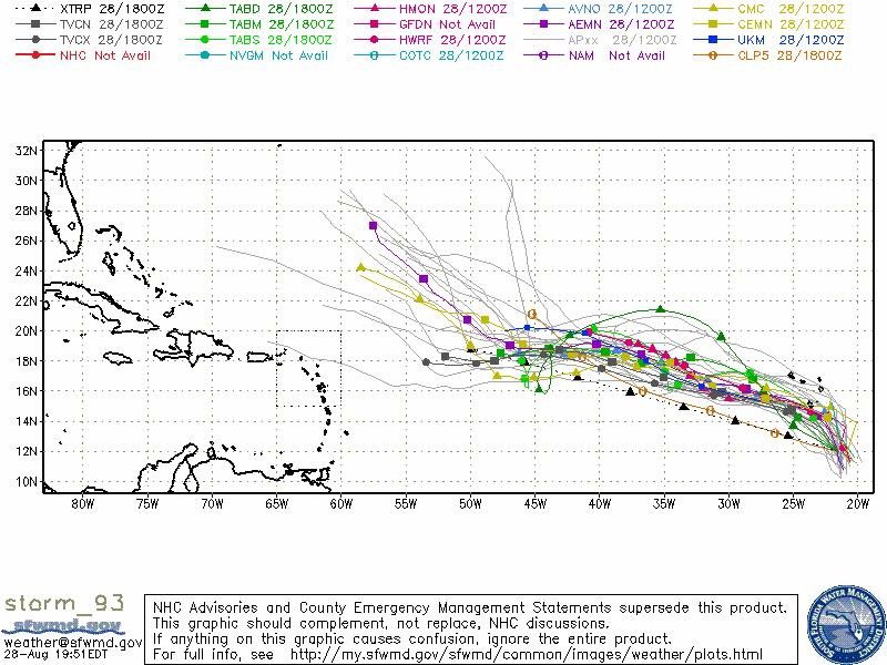
00z guidance.


0 likes
Visit the Caribbean-Central America Weather Thread where you can find at first post web cams,radars
and observations from Caribbean basin members Click Here
and observations from Caribbean basin members Click Here
-
AutoPenalti
- Category 5
- Posts: 4091
- Age: 29
- Joined: Mon Aug 17, 2015 4:16 pm
- Location: Ft. Lauderdale, Florida
Re: ATL: INVEST 93L - Models
facemane wrote:CyclonicFury wrote:18z GFS coming in much weaker. Hope this isn't another 92L or 99L.
I hope it is. if it does develop, I hope it turns NE into the North Atlantic graveyard.
A weaker storm in the MDR, in some cases, means problems for the CONUS.
1 likes
The posts in this forum are NOT official forecasts and should not be used as such. They are just the opinion of the poster and may or may not be backed by sound meteorological data. They are NOT endorsed by any professional institution or STORM2K. For official information, please refer to products from the NHC and NWS.
Model Runs Cheat Sheet:
GFS (5:30 AM/PM, 11:30 AM/PM)
HWRF, GFDL, UKMET, NAVGEM (6:30-8:00 AM/PM, 12:30-2:00 AM/PM)
ECMWF (1:45 AM/PM)
TCVN is a weighted averaged


-
GeneratorPower

- S2K Supporter
- Posts: 1648
- Age: 46
- Joined: Sun Dec 18, 2005 11:48 pm
- Location: Huntsville, AL
Re: ATL: INVEST 93L - Models
AutoPenalti wrote:facemane wrote:CyclonicFury wrote:18z GFS coming in much weaker. Hope this isn't another 92L or 99L.
I hope it is. if it does develop, I hope it turns NE into the North Atlantic graveyard.
A weaker storm in the MDR, in some cases, means problems for the CONUS.
Homegrown and/or delayed development storms make up a large percentage of those storms which affect the USA. As a child I remember watching the Tropical Update on the Weather Channel in the 80s. Storm after storm developed in the MDR and then recurved. Ivan made it all the way across in 2004 but started at extremely low latitude.
0 likes
-
Blown Away

- S2K Supporter
- Posts: 10253
- Joined: Wed May 26, 2004 6:17 am
Re: ATL: INVEST 93L - Models
Nearly all storms that effect Fl from the E won't develop before @55W, same rule generally applies for mid Atlantic strikes, but a few developed farther E and striked mid Atlantic...
1 likes
Hurricane Eye Experience: David 79, Irene 99, Frances 04, Jeanne 04, Wilma 05… Hurricane Brush Experience: Andrew 92, Erin 95, Floyd 99, Matthew 16, Irma 17, Ian 22, Nicole 22…
-
Kingarabian
- S2K Supporter
- Posts: 16364
- Joined: Sat Aug 08, 2009 3:06 am
- Location: Honolulu, Hawaii
Re: ATL: INVEST 93L - Models
00z GFS coming in with more development, similar track.
0 likes
RIP Kobe Bryant

Re: ATL: INVEST 93L - Models
Kingarabian wrote:00z GFS coming in with more development, similar track.
Much further SW so far. This is a different run. Looks closer to Euro.
0 likes
The following post is NOT an official forecast and should not be used as such. It is just the opinion of the poster and may or may not be backed by sound meteorological data. It is NOT endorsed by any professional institution including storm2k.org For Official Information please refer to the NHC and NWS products.
-
SouthFLTropics
- Category 5
- Posts: 4258
- Age: 50
- Joined: Thu Aug 14, 2003 8:04 am
- Location: Port St. Lucie, Florida
Re: ATL: INVEST 93L - Models
Big shift SW on the 00z GFS...trough not near as sharp this run.

0 likes
Fourth Generation Florida Native
Personal Storm History: David 79, Andrew 92, Erin 95, Floyd 99, Irene 99, Frances 04, Jeanne 04, Wilma 05, Matthew 16, Irma 17, Ian 22, Nicole 22, Milton 24
Personal Storm History: David 79, Andrew 92, Erin 95, Floyd 99, Irene 99, Frances 04, Jeanne 04, Wilma 05, Matthew 16, Irma 17, Ian 22, Nicole 22, Milton 24
-
SouthFLTropics
- Category 5
- Posts: 4258
- Age: 50
- Joined: Thu Aug 14, 2003 8:04 am
- Location: Port St. Lucie, Florida
Re: ATL: INVEST 93L - Models
Uh oh...it might be stuck...not sure it escapes, trough looks to be retrograding...

0 likes
Fourth Generation Florida Native
Personal Storm History: David 79, Andrew 92, Erin 95, Floyd 99, Irene 99, Frances 04, Jeanne 04, Wilma 05, Matthew 16, Irma 17, Ian 22, Nicole 22, Milton 24
Personal Storm History: David 79, Andrew 92, Erin 95, Floyd 99, Irene 99, Frances 04, Jeanne 04, Wilma 05, Matthew 16, Irma 17, Ian 22, Nicole 22, Milton 24
Who is online
Users browsing this forum: No registered users and 7 guests