KBBOCA wrote:NWS MiamiVerified account @NWSMiami 2m2 minutes ago
***Fast-moving tornado just reported at Fort Lauderdale International Airport moving NW crossing I-595!** #Irma
Headed right towards me (my home). Oh crap.
Moderator: S2k Moderators

KBBOCA wrote:NWS MiamiVerified account @NWSMiami 2m2 minutes ago
***Fast-moving tornado just reported at Fort Lauderdale International Airport moving NW crossing I-595!** #Irma

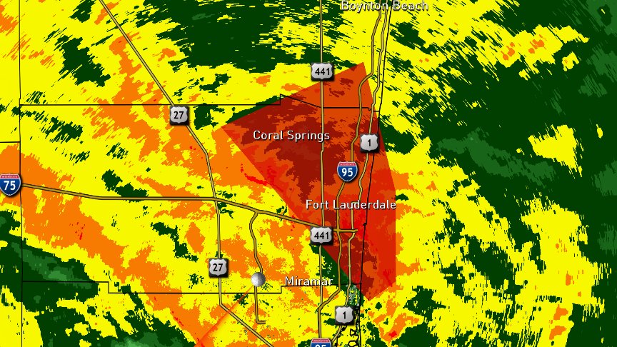

FLC011-086-099-101815-
/O.CON.KMFL.TO.W.0037.000000T0000Z-170910T1815Z/
Miami-Dade FL-Broward FL-Palm Beach FL-
200 PM EDT SUN SEP 10 2017
...A TORNADO WARNING REMAINS IN EFFECT UNTIL 215 PM EDT FOR
NORTHEASTERN MIAMI-DADE...EASTERN BROWARD AND SOUTHEASTERN PALM BEACH
COUNTIES...
At 159 PM EDT, a severe thunderstorm capable of producing a tornado
was located over Hollywood, moving northwest at 70 mph.
HAZARD...Tornado.
SOURCE...Radar indicated rotation.
IMPACT...Flying debris will be dangerous to those caught without
shelter. Mobile homes will be damaged or destroyed. Damage
to roofs, windows, and vehicles will occur. Tree damage is
likely.
Locations impacted include...
Fort Lauderdale, Hollywood, Coral Springs, Pompano Beach and Davie.


ConvergenceZone wrote:Probably about a 90% chance that any strengthing is over, so now it's just a waiting game


northjaxpro wrote:JaxGator wrote:It's stating to go down hill here with the combination of the Nor' Easter and Irma's rainbands coming up from the south. And we had a tornado warning around Cresent Beach near the St. John's- Flagler county line south of St. Augustine.
Yeah I believe that expired. No word yet if it touched down.
There will.be several quick spin up twisters the next 24 hours or so with this landfalling cyclone

Janie2006 wrote:They call it the "opportunity of a lifetime". I call it the opportunity for an early trip to the afterlife. Evidently they aren't taking this seriously.
Meteorcane wrote:ConvergenceZone wrote:Probably about a 90% chance that any strengthing is over, so now it's just a waiting game
I would say 100% chance strengthening is over and weakening has commenced looks like a Cat.2 based on latest recon
Janie2006 wrote:They call it the "opportunity of a lifetime". I call it the opportunity for an early trip to the afterlife. Evidently they aren't taking this seriously.
wx247 wrote:Max sustained winds now down to 120 mph.
BYG Jacob wrote:Ptarmigan wrote:northjaxpro wrote:
A major tropical cyclone as large as Irma is terrible period. Cat 4 or Cat 5 it still equally destructive.
Exactly. A large hurricane is dangerous because they produce higher storm surge.
Again, I acknowledged Irma is a very dangerous hurricane, my point is she would be much more dangerous if she hadn't hit Cuba.
KBBOCA wrote:NWS MiamiVerified account @NWSMiami 2m2 minutes ago
***Fast-moving tornado just reported at Fort Lauderdale International Airport moving NW crossing I-595!** #Irma


KBBOCA wrote:John MoralesVerified account @JohnMoralesNBC6 2m2 minutes ago
Confirmed tornado spotted FLL at 2pm. Tornado warning valid until 2:15 pm @NBC6
ava_ati wrote:JaxGator wrote:It's stating to go down hill here with the combination of the Nor' Easter and Irma's rainbands coming up from the south. And we had a tornado warning around Cresent Beach near the St. John's- Flagler county line south of St. Augustine.
Very odd to me, it sounds like we are getting worse conditions here than they are in Orlando at this point in time, from the reports I've seen here.
PTPatrick wrote:So I'm starting to think surges north of Naples will almost definately underperform. This is just not an optimal angle to pile up and bring in surge above there. Sure the water will come back around and be higher than where it started but I have trouble seeing the epic surge for points north verifying. Which is a good thing. Only time will tell. If you look at donna there was also surge in Naples and Marco but I can't find reports of epic surge north of there. I should say tho, it doesn't take huge surge to do damage in many of these areas as they have not really been built up to mitigate it. Much of the peninsula below the big bend just really takes a perfect storm to create humongous surge because of coastal topography and the typical angle of approach. Back home in Mississippi and really across the northern gulf , the big surges are never preceded by water pushing out. It just comes in, and then in some more and then in some more and then boom it comes in all at once.
Users browsing this forum: No registered users and 22 guests


