BULLETIN
HURRICANE NICOLE ADVISORY NUMBER 38
NWS NATIONAL HURRICANE CENTER MIAMI FL AL152016
1100 AM AST THU OCT 13 2016
...EYE OF NICOLE PASSING OVER BERMUDA...
SUMMARY OF 1100 AM AST...1500 UTC...INFORMATION
-----------------------------------------------
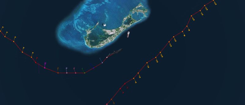
LOCATION...32.3N 64.6W
ABOUT 10 MI...20 KM E OF BERMUDA
MAXIMUM SUSTAINED WINDS...120 MPH...195 KM/H
PRESENT MOVEMENT...NE OR 35 DEGREES AT 16 MPH...26 KM/H
MINIMUM CENTRAL PRESSURE...961 MB...28.38 INCHES
WATCHES AND WARNINGS
--------------------
CHANGES WITH THIS ADVISORY:
None.
SUMMARY OF WATCHES AND WARNINGS IN EFFECT:
A Hurricane Warning is in effect for...
* Bermuda
For storm information specific to your area, please monitor
products issued by your national meteorological service.
DISCUSSION AND 48-HOUR OUTLOOK
------------------------------
At 1100 AM AST (1500 UTC), the center of Hurricane Nicole was
located near latitude 32.3 North, longitude 64.6 West. Nicole is
moving toward the northeast near 16 mph (26 km/h). A northeastward
motion at a faster forward speed is expected during the next day or
so. On the forecast track, the center of Nicole will move away
from Bermuda this afternoon.
Maximum sustained winds are near 120 mph (195 km/h) with higher
gusts. Nicole is a category 3 hurricane on the Saffir-Simpson
Hurricane Wind Scale. Gradual weakening is forecast during the
next couple of days.
Nicole is a large hurricane. Hurricane-force winds extend outward
up to 70 miles (110 km) from the center and tropical-storm-force
winds extend outward up to 185 miles (295 km). An automated
surface station on Pearl Island in Bermuda measured sustained
winds of 87 mph (141 km/h) with a gust to 119 mph (191 km/h).
The latest minimum central pressure reported by reconnaissance
aircraft is 961 mb (28.38 inches). The official reporting station
on Bermuda recently reported a pressure of 963 mb (28.44 inches).
HAZARDS AFFECTING LAND
----------------------
WIND: Do not venture out in the eye. Although winds in eye are
light, hurricane conditions will return soon after the eye
passes and will continue through early afternoon. Tropical
storm conditions will continue through this evening.
STORM SURGE: A dangerous storm surge will raise water levels by as
much as 6 to 8 feet above normal tide levels in Bermuda. The surge
will be accompanied by large and destructive waves.
RAINFALL: Nicole is expected to produce total rain accumulations
of 5 to 8 inches over Bermuda through this evening.
SURF: Swells associated with Nicole will affect Bermuda during the
next few days, and will spread northward along the United States
east coast from the Carolinas northward through the next few days.
These swells will create dangerous surf conditions and rip currents.
Please refer to products being issued by your local weather office
for more information.
NEXT ADVISORY
-------------
Next intermediate advisory at 200 PM AST.
Next complete advisory at 500 PM AST.
$$
Forecaster Brown/Berg
HURRICANE NICOLE DISCUSSION NUMBER 38
NWS NATIONAL HURRICANE CENTER MIAMI FL AL152016
1100 AM AST THU OCT 13 2016
Southwesterly shear is beginning to affect Nicole. Microwave
imagery and Bermuda radar indicate that the eye has lost some
definition and become open to the south. There is also a
significant southwest to northeast tilt between the low-level
center as noted between the radar and satellite presentations
of the eye, and the Air Force center fix that was located near the
extreme western part of the eye seen in satellite imagery. The Air
Force Reserve reconnaissance aircraft has not yet sampled the
eastern portion of the eyewall where the strongest winds were
reported overnight, however, they have reported a minimum pressure
961 mb, which is up several millibars since the previous fix. Based
on the most recent aircraft data and satellite intensity estimates,
the initial wind speed has been set at 105 kt for this advisory.
Although the area of strongest winds in the eastern eyewall are
expected to remain offshore of Bermuda, sustained hurricane-force
winds have been reported on the island during the past couple of
hours. The official observing site at the airport has measured
sustained winds of 67 kt with a gust to 90 kt within the past hour.
Increasingly southwesterly shear and slightly lower sea surface
temperatures along the forecast track of Nicole should cause a
gradual decrease in intensity during the next 24 to 36 hours.
After that time, baroclinic forcing is forecast by the global
models to keep Nicole an intense low pressure area over the
north Atlantic through early next week. The days 3-5 intensity
forecast is in agreement with guidance provided by the NOAA Ocean
Prediction Center.
Nicole has turned northeastward as expected. The hurricane will
move northeastward with some acceleration in forward speed as it
becomes embedded within southwesterly flow ahead of a mid-latitude
trough. The trough is forecast to bypass Nicole in a couple of
days, which is expected to cause the cyclone to slow down and
meander well southeast of Newfoundland late in the forecast period.
The track guidance is in remarkably good agreement, and the NHC is
again near the multi-model consensus.
FORECAST POSITIONS AND MAX WINDS
INIT 13/1500Z 32.3N 64.6W 105 KT 120 MPH
12H 14/0000Z 33.8N 62.4W 95 KT 110 MPH
24H 14/1200Z 35.5N 58.9W 80 KT 90 MPH
36H 15/0000Z 37.0N 54.5W 75 KT 85 MPH
48H 15/1200Z 38.3N 51.3W 75 KT 85 MPH...POST-TROPICAL
72H 16/1200Z 39.0N 48.7W 75 KT 85 MPH...POST-TROPICAL
96H 17/1200Z 39.0N 47.5W 65 KT 75 MPH...POST-TROPICAL
120H 18/1200Z 41.0N 44.5W 60 KT 70 MPH...POST-TROPICAL
$$
Forecaster Brown
NNNN
Visit the Caribbean-Central America Weather Thread where you can find at first post web cams,radars
and observations from Caribbean basin members
Click Here