
90 knot flight level winds!
024930 2935N 08345W 8430 01448 9973 +168 //// 193090 090 056 021 05
025000 2937N 08347W 8434 01444 //// +140 //// 191086 089 056 022 05
025030 2937N 08348W 8430 01435 9960 +160 //// 193086 087 /// /// 05
025100 2936N 08349W 8433 01428 9958 +168 +168 194088 088 057 014 03
025130 2936N 08350W 8429 01429 9953 +167 +167 195088 088 059 016 00
025200 2936N 08352W 8430 01420 9938 +172 +172 200088 089 059 013 00
025230 2935N 08353W 8431 01417 9934 +162 //// 202089 090 062 004 01
025300 2935N 08354W 8429 01415 //// +164 //// 202085 090 063 005 01
ATL: HERMINE - Post-Tropical - Discussion
Moderator: S2k Moderators
Re: ATL: HERMINE - Hurricane - Discussion
025100 2936N 08349W 8433 01428 9958 +168 +168 194088 088 057 014 03
025130 2936N 08350W 8429 01429 9953 +167 +167 195088 088 059 016 00
025200 2936N 08352W 8430 01420 9938 +172 +172 200088 089 059 013 00
025230 2935N 08353W 8431 01417 9934 +162 //// 202089 090 062 004 01
025300 2935N 08354W 8429 01415 //// +164 //// 202085 090 063 005 01
WHOA
I SPOKE TOO SOON
025130 2936N 08350W 8429 01429 9953 +167 +167 195088 088 059 016 00
025200 2936N 08352W 8430 01420 9938 +172 +172 200088 089 059 013 00
025230 2935N 08353W 8431 01417 9934 +162 //// 202089 090 062 004 01
025300 2935N 08354W 8429 01415 //// +164 //// 202085 090 063 005 01
WHOA
I SPOKE TOO SOON
0 likes
-
SunnyThoughts
- Category 5

- Posts: 2263
- Joined: Wed Jul 09, 2003 12:42 pm
- Location: Pensacola, Florida
Re: ATL: HERMINE - Hurricane - Discussion
Wonder how long before the water actually tops those railings on the Cedar Key cam.
0 likes

-
OntarioEggplant
- Category 1

- Posts: 312
- Joined: Sun Aug 07, 2016 11:16 am
Re: ATL: HERMINE - Hurricane - Discussion
BRweather wrote:I will not be surprised if they knock the intensity down back to 75 mph. Probably won't but I think they should
This is silly. They're still measuring higher FL winds now up to 90 KT
1 likes
-
CrazyC83
- Professional-Met

- Posts: 34315
- Joined: Tue Mar 07, 2006 11:57 pm
- Location: Deep South, for the first time!
Re: ATL: HERMINE - Recon
000
URNT15 KNHC 020253
AF304 1409A HERMINE HDOB 27 20160902
024330 2909N 08343W 8437 01480 //// +157 //// 213073 076 045 002 01
024400 2911N 08343W 8425 01491 0002 +166 +163 211077 078 045 005 01
024430 2914N 08343W 8432 01482 9999 +168 +158 210078 078 049 002 00
024500 2916N 08343W 8428 01484 9996 +166 +161 209079 080 050 001 00
024530 2918N 08343W 8425 01480 9990 +169 +156 208082 082 052 003 00
024600 2920N 08343W 8427 01475 9988 +165 +159 205082 083 051 002 01
024630 2922N 08343W 8432 01467 //// +164 //// 204084 085 050 002 01
024700 2925N 08343W 8421 01475 9984 +167 //// 203085 086 051 005 01
024730 2927N 08343W 8428 01467 9981 +166 +166 201085 086 056 007 00
024800 2929N 08343W 8424 01468 9980 +169 +169 199086 087 055 007 00
024830 2932N 08343W 8420 01471 9984 +153 //// 195085 086 054 009 05
024900 2934N 08344W 8428 01454 9977 +171 //// 193086 090 054 012 05
024930 2935N 08345W 8430 01448 9973 +168 //// 193090 090 056 021 05
025000 2937N 08347W 8434 01444 //// +140 //// 191086 089 056 022 05
025030 2937N 08348W 8430 01435 9960 +160 //// 193086 087 /// /// 05
025100 2936N 08349W 8433 01428 9958 +168 +168 194088 088 057 014 03
025130 2936N 08350W 8429 01429 9953 +167 +167 195088 088 059 016 00
025200 2936N 08352W 8430 01420 9938 +172 +172 200088 089 059 013 00
025230 2935N 08353W 8431 01417 9934 +162 //// 202089 090 062 004 01
025300 2935N 08354W 8429 01415 //// +164 //// 202085 090 063 005 01
$$
;
90 kt FL, 63 kt SFMR (may be low due to shoaling).
0 likes
-
tolakram
- Admin

- Posts: 20186
- Age: 62
- Joined: Sun Aug 27, 2006 8:23 pm
- Location: Florence, KY (name is Mark)
Re: ATL: HERMINE - Hurricane - Discussion
Convection has really been building in the SE quad which will come ashore soon.

0 likes
M a r k
- - - - -
Join us in chat: Storm2K Chatroom Invite. Android and IOS apps also available.
The posts in this forum are NOT official forecasts and should not be used as such. Posts are NOT endorsed by any professional institution or STORM2K.org. For official information and forecasts, please refer to NHC and NWS products.
Re: ATL: HERMINE - Hurricane - Discussion
SunnyThoughts wrote:Wonder how long before the water actually tops those railings on the Cedar Key cam.
Doubt it will come up much more.
Storm is going ashore now.
0 likes
-
Aric Dunn
- Category 5
- Posts: 21238
- Age: 43
- Joined: Sun Sep 19, 2004 9:58 pm
- Location: Ready for the Chase.
- Contact:
Re: ATL: HERMINE - Hurricane - Discussion
024500 2916N 08343W 8428 01484 9996 +166 +161 209079 080 050 001 00
024530 2918N 08343W 8425 01480 9990 +169 +156 208082 082 052 003 00
024600 2920N 08343W 8427 01475 9988 +165 +159 205082 083 051 002 01
024630 2922N 08343W 8432 01467 //// +164 //// 204084 085 050 002 01
024700 2925N 08343W 8421 01475 9984 +167 //// 203085 086 051 005 01
024730 2927N 08343W 8428 01467 9981 +166 +166 201085 086 056 007 00
024800 2929N 08343W 8424 01468 9980 +169 +169 199086 087 055 007 00
024830 2932N 08343W 8420 01471 9984 +153 //// 195085 086 054 009 05
024900 2934N 08344W 8428 01454 9977 +171 //// 193086 090 054 012 05
024930 2935N 08345W 8430 01448 9973 +168 //// 193090 090 056 021 05
025000 2937N 08347W 8434 01444 //// +140 //// 191086 089 056 022 05
025030 2937N 08348W 8430 01435 9960 +160 //// 193086 087 /// /// 05
025100 2936N 08349W 8433 01428 9958 +168 +168 194088 088 057 014 03
025130 2936N 08350W 8429 01429 9953 +167 +167 195088 088 059 016 00
025200 2936N 08352W 8430 01420 9938 +172 +172 200088 089 059 013 00
025230 2935N 08353W 8431 01417 9934 +162 //// 202089 090 062 004 01
025300 2935N 08354W 8429 01415 //// +164 //// 202085 090 063 005 01
definitely strengthened .. had this had 4 more hours..
0 likes
Note: If I make a post that is brief. Please refer back to previous posts for the analysis or reasoning. I do not re-write/qoute what my initial post said each time.
If there is nothing before... then just ask
Space & Atmospheric Physicist, Embry-Riddle Aeronautical University,
I believe the sky is falling...
If there is nothing before... then just ask
Space & Atmospheric Physicist, Embry-Riddle Aeronautical University,
I believe the sky is falling...
-
TimeZone
Re: ATL: HERMINE - Hurricane - Discussion
BRweather wrote:I will not be surprised if they knock the intensity down back to 75 mph. Probably won't but I think they should
Why??
0 likes
Re: ATL: HERMINE - Hurricane - Discussion
The eastern eyewall is now very strong, that's where the recon found the 90 knot winds at flight level.
0 likes
-
bamajammer4eva
- Category 4

- Posts: 907
- Joined: Sun Apr 18, 2010 3:21 am
- Location: Ozark, AL
Re: ATL: HERMINE - Hurricane - Discussion
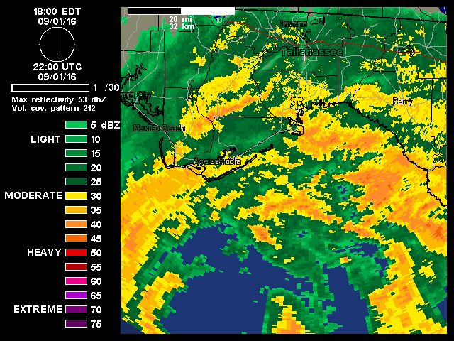
90kt wind showing up on GRlevel3 West in the band west of Dekle Beach. Probably way above ground
Last edited by bamajammer4eva on Thu Sep 01, 2016 10:00 pm, edited 1 time in total.
0 likes
Re: ATL: HERMINE - Hurricane - Discussion
TimeZone wrote:BRweather wrote:I will not be surprised if they knock the intensity down back to 75 mph. Probably won't but I think they should
Why??
They had not been measuring many 50 knot surface winds from recon, but if you read my post I corrected myself with newest recon numbers
0 likes
-
cycloneye

- Admin
- Posts: 149559
- Age: 69
- Joined: Thu Oct 10, 2002 10:54 am
- Location: San Juan, Puerto Rico
Re: ATL: HERMINE - Advisories
HURRICANE HERMINE DISCUSSION NUMBER 19
NWS NATIONAL HURRICANE CENTER MIAMI FL AL092016
1100 PM EDT THU SEP 01 2016
Reports from an Air Force Reserve Hurricane Hunter aircraft
indicate that Hermine has gradually intensified since the last
forecast advisory. The plane measured 86-kt flight-level winds
southeast of the center at 850 mb with SFMR and dropsonde data
suggesting winds of at least 65 kt. Based on these data and a
earlier 983 mb central pressure, the initial intensity is set at 70
kt.
The initial motion remains 030/12. The flow on the eastern side of
a mid-level trough over the southeastern United States should cause
Hermine to move north-northeastward to northeastward with an
increase in forward speed during the next 36 hours. The track
guidance is tightly clustered during this period, and this part of
the forecast track is an update of the previous track. At 48 hours
and beyond, Hermine is expected to interact with a baroclinic trough
over the northeastern United States. The track guidance become
rather divergent during this period, with the GFS and ECMWF models
showing a looping track close to the coast, while the UKMET and
Canadian models show a slow motion somewhat farther offshore. The
new forecast track compromises between these solutions and shows a
slow northeastward motion during this time. Regardless of the exact
track, Hermine should linger for several days near the northeastern
U. S. coast as a vigorous low pressure system.
A little more strengthening is possible during the last few hours
before landfall. After landfall, Hermine is expected to weaken as
it crosses the southeastern United States, eventually emerging from
the North Carolina coast as a tropical storm. The cyclone is
expected to re-intensify as an extratropical low during its
interaction with the baroclinic trough. The forecast intensities
have been raised for this part of the forecast based on global model
forecasts, and it is possible that they are a little conservative.
Later in the forecast period, vertical shear decreases, and the
cyclone could be situated over marginally warm waters. Therefore
there is the possibility of the system regaining some tropical
characteristics in 4-5 days, although this remains speculative.
KEY MESSAGES:
1. As landfall occurs, it is important to not focus on the exact
forecast track. Hermine is an extremely asymmetric storm, with a
large extent of dangerous winds, life-threatening storm surge, and
flooding rains well to the east and southeast of the path of the
center.
2. Hermine is expected to become a post-tropical cyclone while still
producing hazardous winds and storm surge over land. NWS policy
allows NHC to write advisories on and issue tropical storm
watches and warnings for post-tropical cyclones, when the system
continues to pose a significant threat to life and property.
NHC and the NWS Eastern Region have decided that this option will be
invoked for Hermine. After Hermine becomes a post-tropical cyclone,
NHC will continue to issue its full suite of advisory and warning
products for as long as the system remains a significant threat to
land.
FORECAST POSITIONS AND MAX WINDS
INIT 02/0300Z 29.7N 84.3W 70 KT 80 MPH
12H 02/1200Z 31.5N 82.8W 60 KT 70 MPH
24H 03/0000Z 33.6N 79.7W 45 KT 50 MPH...INLAND
36H 03/1200Z 35.6N 75.7W 45 KT 50 MPH...INLAND
48H 04/0000Z 37.0N 73.2W 50 KT 60 MPH...POST-TROP/EXTRATROP
72H 05/0000Z 38.0N 72.5W 55 KT 65 MPH...POST-TROP/EXTRATROP
96H 06/0000Z 39.0N 72.0W 55 KT 65 MPH...POST-TROP/EXTRATROP
120H 07/0000Z 39.5N 70.5W 50 KT 60 MPH...POST-TROP/EXTRATROP
$$
Forecaster Beven
0 likes
Visit the Caribbean-Central America Weather Thread where you can find at first post web cams,radars
and observations from Caribbean basin members Click Here
and observations from Caribbean basin members Click Here
-
Aric Dunn
- Category 5
- Posts: 21238
- Age: 43
- Joined: Sun Sep 19, 2004 9:58 pm
- Location: Ready for the Chase.
- Contact:
Re: ATL: HERMINE - Hurricane - Discussion
bamajammer4eva wrote:90kt wind showing up on GRlevel3 West in the band west of Dekle Beach. Probably way above ground
yeas seeing 92kts on GR ..
0 likes
Note: If I make a post that is brief. Please refer back to previous posts for the analysis or reasoning. I do not re-write/qoute what my initial post said each time.
If there is nothing before... then just ask
Space & Atmospheric Physicist, Embry-Riddle Aeronautical University,
I believe the sky is falling...
If there is nothing before... then just ask
Space & Atmospheric Physicist, Embry-Riddle Aeronautical University,
I believe the sky is falling...
-
Hurricane Andrew

- S2K Supporter

- Posts: 1891
- Age: 27
- Joined: Sun May 23, 2010 2:53 pm
- Location: KS
Re: ATL: HERMINE - Hurricane - Discussion
100mph winds in the eastern eyewall...2-3 thousand feet above ground. Anyone have the ratio on that?
0 likes
The Enthusiast
NREMT-AEMT, WX nerd
Irene '11, Sandy '12, Irma '17 (SAR)
"Hard to think we were born to live this way..." -Wage War

Re: ATL: HERMINE - Hurricane - Discussion
I drove down to irb earlier about an hour ago.. Man that was scary.. 8foot or more waves... No beach left.. Waves crashing onto the boardwalk...
1 likes
-
PTrackerLA

- Category 5
- Posts: 5281
- Age: 42
- Joined: Thu Oct 10, 2002 8:40 pm
- Location: Lafayette, LA
Re: ATL: HERMINE - Hurricane - Discussion
Jim Cantore's live shot all you hear is frogs lol. Seems really calm at Carrabelle, FL.
4 likes
Re: ATL: HERMINE - Hurricane - Discussion
LOL
Jim Cantore is on the western eyewall in Carrabelle and it looks like a normal night. Poor guy made that trip for nothing,
Jim Cantore is on the western eyewall in Carrabelle and it looks like a normal night. Poor guy made that trip for nothing,
0 likes
-
SeGaBob
Who is online
Users browsing this forum: No registered users and 16 guests