Don't see much happening unless the ull pulls enough away.
It seems to be doing that, but the dry air and shear is also inhibiting development.
Could get interesting. That really strong ull yesterday inhibited Gaston and now that it has pulled away it has really blown up.
ATL: EIGHT - Remnants - Discussion
Moderator: S2k Moderators
-
OuterBanker
- S2K Supporter

- Posts: 1761
- Joined: Wed Feb 26, 2003 10:53 am
- Location: Nags Head, NC
- Contact:
Re: ATL: INVEST 91L - Discussion
1 likes

Re: ATL: INVEST 91L - Discussion
CrazyC83 wrote:Could a possible analog to this be Danielle 1992?
I'd think so, or maybe Cristobal 2002.
0 likes
Igor 2010, Sandy 2012, Fay 2014, Gonzalo 2014, Joaquin 2015, Nicole 2016, Humberto 2019, Imelda 2025
I am only a tropical weather enthusiast. My predictions are not official and may or may not be backed by sound meteorological data. For official information, please refer to the NHC and NWS products.
I am only a tropical weather enthusiast. My predictions are not official and may or may not be backed by sound meteorological data. For official information, please refer to the NHC and NWS products.
-
tolakram
- Admin

- Posts: 20186
- Age: 62
- Joined: Sun Aug 27, 2006 8:23 pm
- Location: Florence, KY (name is Mark)
Re: ATL: INVEST 91L - Discussion
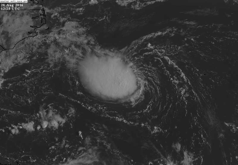
I think this might be a TD.
http://weather.msfc.nasa.gov/cgi-bin/get-goes?satellite=GOES-E%20CONUS&lat=32&lon=-71&info=vis&zoom=1&width=1000&height=800&quality=90&type=Animation&palette=ir1.pal&numframes=10&mapcolor=yellow
http://weather.msfc.nasa.gov/cgi-bin/get-goes?satellite=GOES-E%20CONUS&lat=32&lon=-71&info=vis&zoom=1&width=1000&height=800&quality=90&type=Animation&palette=ir1.pal&numframes=10&mapcolor=yellow
0 likes
M a r k
- - - - -
Join us in chat: Storm2K Chatroom Invite. Android and IOS apps also available.
The posts in this forum are NOT official forecasts and should not be used as such. Posts are NOT endorsed by any professional institution or STORM2K.org. For official information and forecasts, please refer to NHC and NWS products.
-
cycloneye

- Admin
- Posts: 149548
- Age: 69
- Joined: Thu Oct 10, 2002 10:54 am
- Location: San Juan, Puerto Rico
Re: ATL: INVEST 91L - Discussion
Shower and thunderstorm activity has increased during the past few
hours in association with an area of low pressure located about 250
miles west of Bermuda. While environmental conditions are only
marginally conducive, some additional development of this system is
possible during the next day or so while it moves west-northwestward
at about 10 mph. As the low approaches the coast of North Carolina
by mid-week, conditions are expected to become unfavorable for
further development. For additional information on this system, see
High Seas Forecasts issued by the National Weather Service. An Air
Force Reserve Hurricane Hunter aircraft is scheduled to investigate
this system this afternoon, if necessary.
* Formation chance through 48 hours...medium...40 percent
* Formation chance through 5 days...medium...40 percent
0 likes
Visit the Caribbean-Central America Weather Thread where you can find at first post web cams,radars
and observations from Caribbean basin members Click Here
and observations from Caribbean basin members Click Here
-
cycloneye
- Admin
- Posts: 149548
- Age: 69
- Joined: Thu Oct 10, 2002 10:54 am
- Location: San Juan, Puerto Rico
Re: ATL: INVEST 91L - Discussion
0 likes
Visit the Caribbean-Central America Weather Thread where you can find at first post web cams,radars
and observations from Caribbean basin members Click Here
and observations from Caribbean basin members Click Here
-
txwatcher91
- Category 5

- Posts: 1498
- Joined: Tue Aug 02, 2005 2:29 pm
Re: ATL: INVEST 91L - Discussion
How is this not a TD at least? Yesterday's ASCAT pass indicated a close surface circulation and you can tell from this mornings visible it is as well. Nice convective burst too despite some shear.
0 likes

Re: ATL: INVEST 91L - Discussion
Time for an upgrade to TD, IMO. Its long term life is not too promising though. Brennan is being way too conservative this morning.
0 likes

Re: ATL: INVEST 91L - Discussion
NHC has been behind the curve with this system right from the off it seems, maybe too busy focusing in on 99L due to the immediate land effects but this one deserves an upgrade now. Indeed its probably been a TD/TS for a while I suspect.Should squeeze a TS out of this I think.
0 likes
Personal Forecast Disclaimer:
The posts in this forum are NOT official forecast and should not be used as such. They are just the opinion of the poster and may or may not be backed by sound meteorological data. They are NOT endorsed by any professional institution or storm2k.org. For official information, please refer to the NHC and NWS products
The posts in this forum are NOT official forecast and should not be used as such. They are just the opinion of the poster and may or may not be backed by sound meteorological data. They are NOT endorsed by any professional institution or storm2k.org. For official information, please refer to the NHC and NWS products
-
tolakram
- Admin
- Posts: 20186
- Age: 62
- Joined: Sun Aug 27, 2006 8:23 pm
- Location: Florence, KY (name is Mark)
Re: ATL: INVEST 91L - Discussion
0 likes
M a r k
- - - - -
Join us in chat: Storm2K Chatroom Invite. Android and IOS apps also available.
The posts in this forum are NOT official forecasts and should not be used as such. Posts are NOT endorsed by any professional institution or STORM2K.org. For official information and forecasts, please refer to NHC and NWS products.
- - - - -
Join us in chat: Storm2K Chatroom Invite. Android and IOS apps also available.
The posts in this forum are NOT official forecasts and should not be used as such. Posts are NOT endorsed by any professional institution or STORM2K.org. For official information and forecasts, please refer to NHC and NWS products.
-
Emmett_Brown

- Category 5
- Posts: 1433
- Joined: Wed Aug 24, 2005 9:10 pm
- Location: Sarasota FL
Re: ATL: INVEST 91L - Discussion
Skipping TD and going straight to TS and is much more en vogue. (You don't see a lot of TD's form any more... seems like they go straight to TS, they seem really careful about whether an LLC is truly closed). I wouldn't be surprised to see this become Hermine in the next day or two.
Last edited by Emmett_Brown on Sun Aug 28, 2016 8:28 am, edited 1 time in total.
0 likes
-
deltadog03

- Professional-Met

- Posts: 3580
- Joined: Tue Jul 05, 2005 6:16 pm
- Location: Macon, GA

Re: ATL: INVEST 91L - Discussion
I agree, it looks like a TD already. It would be funny if this ends up being and Hermine and not 99L which has virtually been called Hermine since forever 
0 likes
-
OuterBanker
- S2K Supporter
- Posts: 1761
- Joined: Wed Feb 26, 2003 10:53 am
- Location: Nags Head, NC
- Contact:
Re: ATL: INVEST 91L - Discussion
How interesting. Looked pitifull last night, ready to write it off. NWS local only mentions lighter winds and a weak system with increased shower activity in the 6:40 am approaching the area. But, it looks a lot better than the forecast. In fact it looks better than 99l. Still not aligned well, but a very symetrical vivid llc. From the looks of it they should still fly. I wonder what recon will find. Oh yea, it's making a b-line towards us so I guess I have a vested interest.
0 likes
-
Three Blind Mice

- Tropical Storm

- Posts: 202
- Joined: Thu Jul 29, 2004 9:28 am
- Location: Wrightsville Beach, NC

Re: ATL: INVEST 91L - Discussion
Looks like they're catching up at SSD. I guess they're waiting for recon?
0 likes

-
tolakram
- Admin
- Posts: 20186
- Age: 62
- Joined: Sun Aug 27, 2006 8:23 pm
- Location: Florence, KY (name is Mark)
Re: ATL: INVEST 91L - Discussion

0 likes
M a r k
- - - - -
Join us in chat: Storm2K Chatroom Invite. Android and IOS apps also available.
The posts in this forum are NOT official forecasts and should not be used as such. Posts are NOT endorsed by any professional institution or STORM2K.org. For official information and forecasts, please refer to NHC and NWS products.
- - - - -
Join us in chat: Storm2K Chatroom Invite. Android and IOS apps also available.
The posts in this forum are NOT official forecasts and should not be used as such. Posts are NOT endorsed by any professional institution or STORM2K.org. For official information and forecasts, please refer to NHC and NWS products.

-
TimeZone
Re: ATL: INVEST 91L - Discussion
Looks to be a TD/TS to me as well. Not really sure what the NHC is doing here.
0 likes
Who is online
Users browsing this forum: No registered users and 31 guests