I was surprised that it formed inland over Florida
Sent from my SM-G550T1 using Tapatalk
ATL: JULIA - Post-Tropical - Discussion
Moderator: S2k Moderators
-
hurricanefloyd5

- Category 5

- Posts: 1659
- Age: 45
- Joined: Sun May 02, 2004 10:53 am
- Location: Spartanburg
- Contact:
-
cycloneye

- Admin

- Posts: 149550
- Age: 69
- Joined: Thu Oct 10, 2002 10:54 am
- Location: San Juan, Puerto Rico
Re: ATL: JULIA - Advisories
BULLETIN
TROPICAL STORM JULIA ADVISORY NUMBER 4
NWS NATIONAL HURRICANE CENTER MIAMI FL AL112016
500 PM EDT WED SEP 14 2016
...JULIA CONTINUES MOVING NORTHEASTWARD JUST OFF THE SOUTHEAST
UNITED STATES COAST...
SUMMARY OF 500 PM EDT...2100 UTC...INFORMATION
----------------------------------------------
LOCATION...32.1N 80.5W
ABOUT 35 MI...55 KM E OF SAVANNAH GEORGIA
MAXIMUM SUSTAINED WINDS...40 MPH...65 KM/H
PRESENT MOVEMENT...NE OR 40 DEGREES AT 6 MPH...9 KM/H
MINIMUM CENTRAL PRESSURE...1011 MB...29.86 INCHES
TROPICAL STORM JULIA DISCUSSION NUMBER 4
NWS NATIONAL HURRICANE CENTER MIAMI FL AL112016
500 PM EDT WED SEP 14 2016
The storm continues to have an asymmetric cloud pattern, with
little deep convection over the western and southern portions of
the circulation. The current intensity estimate remains at 35 kt
based on WSR-88D Doppler velocity data. Since the system is
expected to be over water for the next couple of days, some
strengthening is now possible. However the vertical shear, which
is currently approaching 20 kt, is forecast by the dynamical models
to increase to near 30 kt in 48 hours. This strong shear should
limit significant intensification, as indicated in the latest
official forecast. The NHC forecast is also very close to
the latest intensity model consensus.
Visible satellite images and surface observations indicate that the
cyclone continues moving northeastward, or around 040/5 kt.
Julia is likely to remain in a weak steering environment, near the
axis of the subtropical ridge, for the next few days. Most
of the track guidance shows a slow and erratic motion, and the GFS
and ECMWF global models depict the system looping back to the
coast in several days. This is also shown in the latest official
track forecast, which is shifted considerably east of the previous
NHC prediction.
FORECAST POSITIONS AND MAX WINDS
INIT 14/2100Z 32.1N 80.5W 35 KT 40 MPH
12H 15/0600Z 32.3N 80.1W 35 KT 40 MPH
24H 15/1800Z 32.4N 79.4W 40 KT 45 MPH
36H 16/0600Z 32.3N 79.0W 40 KT 45 MPH
48H 16/1800Z 32.2N 79.0W 40 KT 45 MPH
72H 17/1800Z 32.0N 80.0W 35 KT 40 MPH
96H 18/1800Z 32.2N 80.5W 30 KT 35 MPH
120H 19/1800Z 32.5N 81.0W 25 KT 30 MPH...POST-TROP/EXTRATROP
$$
Forecaster Pasch
0 likes
Visit the Caribbean-Central America Weather Thread where you can find at first post web cams,radars
and observations from Caribbean basin members Click Here
and observations from Caribbean basin members Click Here
-
rickybobby
- Tropical Storm

- Posts: 174
- Joined: Fri Sep 18, 2015 11:11 am
- Location: Central Florida
Re: ATL: JULIA - Tropical Storm - Discussion
Wesh 2 just said some models are trying to make it recurve and hit at the ga/fl line later this week.
0 likes

Re: ATL: JULIA - Tropical Storm - Discussion
hurricanefloyd5 wrote:I was surprised that it formed inland over Florida
Sent from my SM-G550T1 using Tapatalk
It didn't form over land. The best track position has it becoming a TD over the water and then it made landfall as a minimal TS
0 likes
-
JtSmarts

- S2K Supporter

- Posts: 1442
- Age: 40
- Joined: Thu Jul 10, 2003 1:29 pm
- Location: Columbia, South Carolina
Re: ATL: JULIA - Tropical Storm - Discussion
With a few days meandering around in warm waters, it's good to have that shear keep her check before she heads back west. Otherwise we could be dealing a much bigger problem.
0 likes
-
centuryv58

- Tropical Storm
- Posts: 233
- Age: 67
- Joined: Sat Jul 30, 2016 1:24 pm
- Location: Southeast Florida
Re: ATL: JULIA - Tropical Storm - Discussion
Alyono wrote:hurricanefloyd5 wrote:I was surprised that it formed inland over Florida
Sent from my SM-G550T1 using Tapatalk
It didn't form over land. The best track position has it becoming a TD over the water and then it made landfall as a minimal TS
Somebody ought to get a corrective press release out then as all my area news outlets say it formed over land.
0 likes
Re: ATL: JULIA - Tropical Storm - Discussion
centuryv58 wrote:Alyono wrote:hurricanefloyd5 wrote:I was surprised that it formed inland over Florida
Sent from my SM-G550T1 using Tapatalk
It didn't form over land. The best track position has it becoming a TD over the water and then it made landfall as a minimal TS
Somebody ought to get a corrective press release out then as all my area news outlets say it formed over land.
Because those news outlets are using the operational track alone. Here is the best track
AL, 11, 2016091306, , BEST, 0, 273N, 802W, 30, 1012, TD, 0, , 0, 0, 0, 0, 1014, 80, 50, 0, 0, L, 0, , 0, 0, INVEST, S,
AL, 11, 2016091312, , BEST, 0, 281N, 808W, 35, 1010, TS, 34, NEQ, 40, 40, 0, 0, 1014, 80, 50, 0, 0, L, 0, , 0, 0, INVEST, S,
AL, 11, 2016091318, , BEST, 0, 290N, 813W, 35, 1010, TS, 34, NEQ, 50, 50, 0, 0, 1015, 120, 40, 0, 0, L, 0, , 0, 0, INVEST, S,
AL, 11, 2016091400, , BEST, 0, 299N, 815W, 35, 1010, TS, 34, NEQ, 40, 40, 0, 0, 1015, 120, 40, 45, 0, L, 0, , 0, 0, JULIA, M, 0, , 0, 0, 0, 0, TRANSITIONED, alD32016 to al112016,
AL, 11, 2016091406, , BEST, 0, 306N, 818W, 35, 1012, TS, 34, NEQ, 70, 0, 0, 0, 1015, 90, 50, 45, 0, L, 0, , 0, 0, JULIA, M, 12, NEQ, 40, 0, 0, 0,
AL, 11, 2016091412, , BEST, 0, 314N, 815W, 35, 1011, TS, 34, NEQ, 100, 0, 0, 0, 1016, 90, 60, 45, 0, L, 0, , 0, 0, JULIA, M, 12, NEQ, 40, 0, 0, 0,
AL, 11, 2016091418, , BEST, 0, 319N, 807W, 35, 1011, TS, 34, NEQ, 100, 0, 0, 60, 1016, 90, 60, 45, 0, L, 0, , 0, 0, JULIA, M,
clearly formed over the water
0 likes
-
centuryv58
- Tropical Storm
- Posts: 233
- Age: 67
- Joined: Sat Jul 30, 2016 1:24 pm
- Location: Southeast Florida
Re: ATL: JULIA - Tropical Storm - Discussion
Alyono wrote:centuryv58 wrote:Alyono wrote:
It didn't form over land. The best track position has it becoming a TD over the water and then it made landfall as a minimal TS
Somebody ought to get a corrective press release out then as all my area news outlets say it formed over land.
Because those news outlets are using the operational track alone. Here is the best track
AL, 11, 2016091306, , BEST, 0, 273N, 802W, 30, 1012, TD, 0, , 0, 0, 0, 0, 1014, 80, 50, 0, 0, L, 0, , 0, 0, INVEST, S,
AL, 11, 2016091312, , BEST, 0, 281N, 808W, 35, 1010, TS, 34, NEQ, 40, 40, 0, 0, 1014, 80, 50, 0, 0, L, 0, , 0, 0, INVEST, S,
AL, 11, 2016091318, , BEST, 0, 290N, 813W, 35, 1010, TS, 34, NEQ, 50, 50, 0, 0, 1015, 120, 40, 0, 0, L, 0, , 0, 0, INVEST, S,
AL, 11, 2016091400, , BEST, 0, 299N, 815W, 35, 1010, TS, 34, NEQ, 40, 40, 0, 0, 1015, 120, 40, 45, 0, L, 0, , 0, 0, JULIA, M, 0, , 0, 0, 0, 0, TRANSITIONED, alD32016 to al112016,
AL, 11, 2016091406, , BEST, 0, 306N, 818W, 35, 1012, TS, 34, NEQ, 70, 0, 0, 0, 1015, 90, 50, 45, 0, L, 0, , 0, 0, JULIA, M, 12, NEQ, 40, 0, 0, 0,
AL, 11, 2016091412, , BEST, 0, 314N, 815W, 35, 1011, TS, 34, NEQ, 100, 0, 0, 0, 1016, 90, 60, 45, 0, L, 0, , 0, 0, JULIA, M, 12, NEQ, 40, 0, 0, 0,
AL, 11, 2016091418, , BEST, 0, 319N, 807W, 35, 1011, TS, 34, NEQ, 100, 0, 0, 60, 1016, 90, 60, 45, 0, L, 0, , 0, 0, JULIA, M,
clearly formed over the water
Ok, I'll email this to the CBS Evening News as they just said again it formed over land.
0 likes
-
johngaltfla

- Category 5
- Posts: 2073
- Joined: Sun Jul 10, 2005 9:17 pm
- Location: Sarasota County, FL
- Contact:
Re: ATL: JULIA - Tropical Storm - Discussion
I'm just glad it is further away from me. One of the squall lines hit last night, boom, lightning strike to a transformer and no power for just over 5 hours.
Nothing like trying to sleep when it is 83 with mega humidity outside. Good luck to y'all in GA/SC!
Nothing like trying to sleep when it is 83 with mega humidity outside. Good luck to y'all in GA/SC!
0 likes
-
northjaxpro

- S2K Supporter
- Posts: 8900
- Joined: Mon Sep 27, 2010 11:21 am
- Location: Jacksonville, FL
Re: ATL: JULIA - Tropical Storm - Discussion
Excerpt from Dr. Jeff Masters from Weather Underground:
In a rare surprise, the Atlantic experienced the formation of a tropical storm with its center located over land on Tuesday evening, when Tropical Storm Julia emerged at 11 pm EDT, centered about five miles west of Jacksonville, Florida. Tropical cyclones (comprising all tropical depressions, tropical storms, and hurricanes) derive their energy from the warm waters of the ocean, so it is very difficult—but not unheard of—for a storm to get its start while centered over land. Julia was helped out by its very large circulation, which pulled a tremendous amount of moisture-laden air from a wide area of ocean. The waters off the coast of Florida that fed Julia featured the exceptional warmth of the Gulf Stream Current, at the time of year when ocean temperatures are at their peak.
__________________________________________________________________________________
Totally agree with Dr. Masters. Also, I thought he is spot on about the Gulf Stream feeding Julia to help to develop the tropical cyclone over land. I mentioned that as well very earlier this morning on this thread.
1 likes
NEVER, EVER SAY NEVER in the tropics and weather in general, and most importantly, with life itself!!
________________________________________________________________________________________
Fay 2008 Beryl 2012 Debby 2012 Colin 2016 Hermine 2016 Julia 2016 Matthew 2016 Irma 2017 Dorian 2019
________________________________________________________________________________________
Fay 2008 Beryl 2012 Debby 2012 Colin 2016 Hermine 2016 Julia 2016 Matthew 2016 Irma 2017 Dorian 2019
Re: ATL: JULIA - Tropical Storm - Discussion
Gotta love it. Only in Savannah, Ga can you get a tropical storm go right over you and get....nothing.
1 likes
-
SeGaBob
Re: ATL: JULIA - Tropical Storm - Discussion
Still appears to be racing NE at the moment... I see no reason for it to stop like the models say it will. Models handled this storm horribly so far.
0 likes
Re: ATL: JULIA - Tropical Storm - Discussion
If this makes it to 78E, conditions should be favorable for significant intensification.
The GFDL and Canadian both take this east of 78, as did the 18Z 4km NAM. They all blew this up
The GFDL and Canadian both take this east of 78, as did the 18Z 4km NAM. They all blew this up
0 likes
-
JtSmarts
- S2K Supporter
- Posts: 1442
- Age: 40
- Joined: Thu Jul 10, 2003 1:29 pm
- Location: Columbia, South Carolina
Re: ATL: JULIA - Tropical Storm - Discussion
Alyono wrote:If this makes it to 78E, conditions should be favorable for significant intensification.
The GFDL and Canadian both take this east of 78, as did the 18Z 4km NAM. They all blew this up
If this happens, will it head on out to sea instead of heading back towards the west?
0 likes
Re: ATL: JULIA - Tropical Storm - Discussion
GTStorm wrote: Gotta love it. Only in Savannah, Ga can you get a tropical storm go right over you and get....nothing.
That's not unusual at all for a sheared TS whose center actually passed a bit to the east. That's why the NHC knew not to extend warnings all of the way up to there. Actually, earlier NHC and model forecasts had the center a solid 50 miles west of SAV. Had that occurred, the rainfall almost definitely would have been much heavier. But, alas, the models didn't have a clue.
TS Colin was another storm which passed to the east and was pretty much nothing. OTOH, Hermine, which passed a little to the west, had a major impact with 3-5" of rain, strong winds with gusts into the 50's, and a whopping 47K power outages! Of course, Hermine was a more powerful storm, too. SAV didn't need another Hermine!
1 likes
Personal Forecast Disclaimer:
The posts in this forum are NOT official forecasts and should not be used as such. They are just the opinion of the poster and may or may not be backed by sound meteorological data. They are NOT endorsed by any professional institution or storm2k.org. For official information, please refer to the NHC and NWS products.
The posts in this forum are NOT official forecasts and should not be used as such. They are just the opinion of the poster and may or may not be backed by sound meteorological data. They are NOT endorsed by any professional institution or storm2k.org. For official information, please refer to the NHC and NWS products.
Re: ATL: JULIA - Tropical Storm - Discussion
SeGaBob wrote:Still appears to be racing NE at the moment... I see no reason for it to stop like the models say it will. Models handled this storm horribly so far.
I don't think it is racing, but I largely agree with you as the models are and have been clueless. I'm still thinking it will most likely continue NE simlar to what the 12Z CMC did.
0 likes
Personal Forecast Disclaimer:
The posts in this forum are NOT official forecasts and should not be used as such. They are just the opinion of the poster and may or may not be backed by sound meteorological data. They are NOT endorsed by any professional institution or storm2k.org. For official information, please refer to the NHC and NWS products.
The posts in this forum are NOT official forecasts and should not be used as such. They are just the opinion of the poster and may or may not be backed by sound meteorological data. They are NOT endorsed by any professional institution or storm2k.org. For official information, please refer to the NHC and NWS products.
-
cycloneye
- Admin
- Posts: 149550
- Age: 69
- Joined: Thu Oct 10, 2002 10:54 am
- Location: San Juan, Puerto Rico
Re: ATL: JULIA - Advisories
BULLETIN
TROPICAL STORM JULIA ADVISORY NUMBER 5
NWS NATIONAL HURRICANE CENTER MIAMI FL AL112016
1100 PM EDT WED SEP 14 2016
...JULIA FORECAST TO MEANDER JUST OFF THE SOUTHEAST UNITED STATES
COAST...
SUMMARY OF 1100 PM EDT...0300 UTC...INFORMATION
-----------------------------------------------
LOCATION...32.1N 79.8W
ABOUT 50 MI...80 KM SSE OF CHARLESTON SOUTH CAROLINA
MAXIMUM SUSTAINED WINDS...40 MPH...65 KM/H
PRESENT MOVEMENT...ENE OR 60 DEGREES AT 5 MPH...7 KM/H
MINIMUM CENTRAL PRESSURE...1009 MB...29.80 INCHES
TROPICAL STORM JULIA DISCUSSION NUMBER 5
NWS NATIONAL HURRICANE CENTER MIAMI FL AL112016
1100 PM EDT WED SEP 14 2016
The low-level circulation has become a little bit elongated, and
due to southwesterly shear most of the convection has shifted to the
northeast of the center. A convective band is still wrapping around
the eastern portion of the cyclone. Based on surface observations,
WSR-88D Doppler velocity data, and satellite estimates, the initial
intensity is kept at 35 kt. Since the cyclone is over water, some
slight intensification is possible during the next day or so before
the shear increases as forecast by global models. A gradual
weakening should then begin in about 36 hours.
Julia appears to be moving toward the east-northeast at about 4 kt.
The steering currents are forecast to collapse, and most of the
models keep a weakening cyclone meandering during the next few days.
The NHC track forecast follows such a trend and predicts a very slow
eastward drift during the next 48 hours. Little motion is
anticipated thereafter.
FORECAST POSITIONS AND MAX WINDS
INIT 15/0300Z 32.1N 79.8W 35 KT 40 MPH
12H 15/1200Z 32.2N 79.2W 35 KT 40 MPH
24H 16/0000Z 32.2N 78.8W 40 KT 45 MPH
36H 16/1200Z 32.1N 78.6W 35 KT 40 MPH
48H 17/0000Z 32.0N 78.5W 35 KT 40 MPH
72H 18/0000Z 32.0N 79.0W 30 KT 35 MPH
96H 19/0000Z 32.0N 79.0W 30 KT 35 MPH
120H 20/0000Z 32.0N 79.0W 25 KT 30 MPH...POST-TROP/REMNT LOW
$$
Forecaster Avila
0 likes
Visit the Caribbean-Central America Weather Thread where you can find at first post web cams,radars
and observations from Caribbean basin members Click Here
and observations from Caribbean basin members Click Here


Re: ATL: JULIA - Tropical Storm - Discussion
Look at the 3-day cone for Julia.
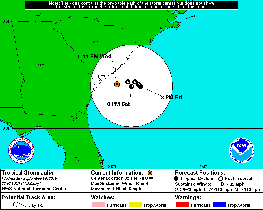
Now look at the 5-day cone.
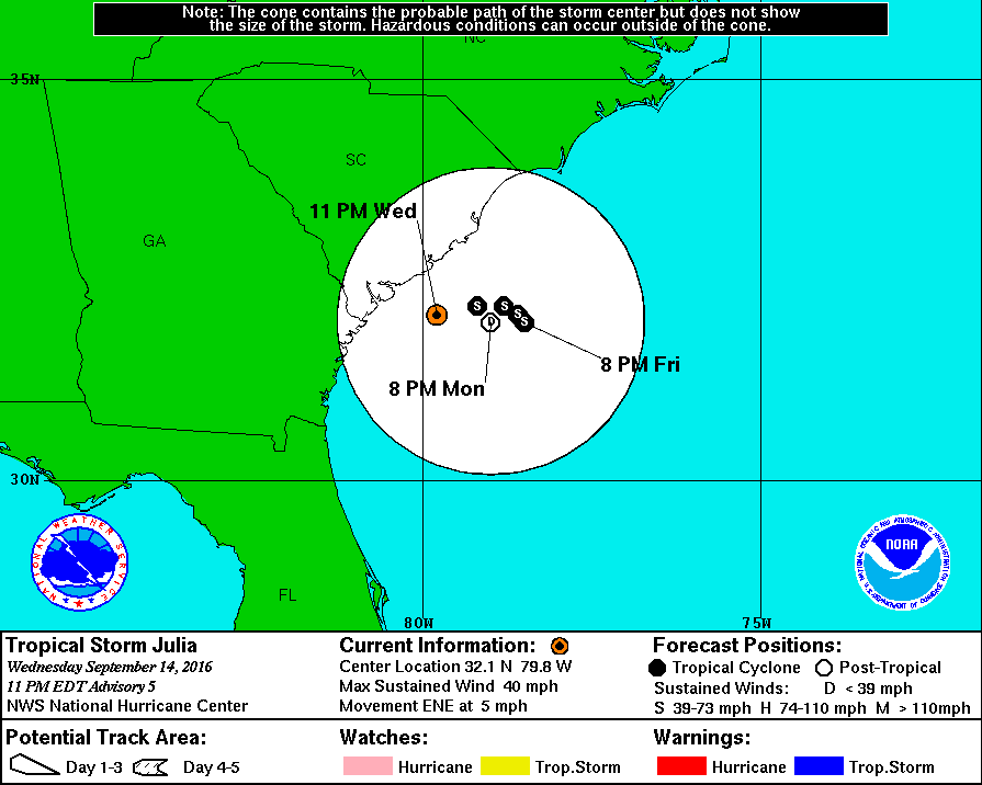

Also, there is something wrong with the 5-day cone. What is it?
Now look at the 5-day cone.
Also, there is something wrong with the 5-day cone. What is it?
0 likes

Re: ATL: JULIA - Tropical Storm - Discussion
That's no cone my friend, that's a perfect circle!!
1 likes
Georges '98, Irene '99, Frances '04, Jeanne '04, Katrina '05, Wilma '05, Gustav '08, Isaac '12, Matthew '16, Florence '18, Michael '18, Ian '22


Re: ATL: JULIA - Tropical Storm - Discussion
LarryWx wrote:GTStorm wrote: Gotta love it. Only in Savannah, Ga can you get a tropical storm go right over you and get....nothing.
That's not unusual at all for a sheared TS whose center actually passed a bit to the east. That's why the NHC knew not to extend warnings all of the way up to there. Actually, earlier NHC and model forecasts had the center a solid 50 miles west of SAV. Had that occurred, the rainfall almost definitely would have been much heavier. But, alas, the models didn't have a clue.
TS Colin was another storm which passed to the east and was pretty much nothing. OTOH, Hermine, which passed a little to the west, had a major impact with 3-5" of rain, strong winds with gusts into the 50's, and a whopping 47K power outages! Of course, Hermine was a more powerful storm, too. SAV didn't need another Hermine!
Hermine left 70,000 people without power in Tallahassee alone late Thurs/ early Fri. Wakulla County, which took the bigger hit, had most of the population without power; Some for a week. Rain totals in some areas reached 12" and more.
0 likes
Who is online
Users browsing this forum: No registered users and 26 guests