

ATL: EARL - Remnants - Discussion
Moderator: S2k Moderators

Re: ATL: INVEST 97L - Discussion
Feeling the effects of the Shreader.

0 likes
The following post is NOT an official forecast and should not be used as such. It is just the opinion of the poster and may or may not be backed by sound meteorological data. It is NOT endorsed by any professional institution including storm2k.org For Official Information please refer to the NHC and NWS products.
Re: ATL: INVEST 97L - Discussion
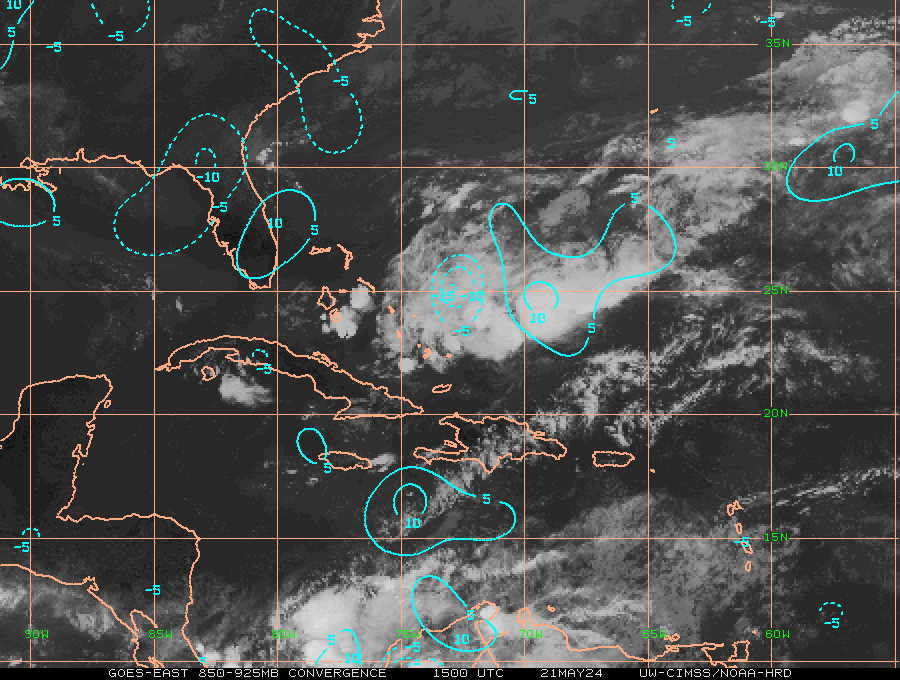
Hammy wrote:Nimbus wrote:NDG wrote:Like I have been saying maybe the HWRF is not so far off after all with the latest Euro run joining it of an LLC forming later today and 97L really take off as it heads towards the GOH.
It will be interesting to see what vis satellite shows later this morning.
One interesting thing is that the bouy south of Jamaica is reporting much lighter winds compared to yesterday morning indicative that the trades have slowed down ahead of 97L which may help in an LLC to form.
The CDO has persisted so if there is a low level center underneath it must not be moving west as fast since it has not outrun the CDO. If they initialize the models with a TS we might get better model output. The shallow and deep layer BAMM have been generating a similar track but that was assuming a weak initial system.
There seems to be increasing shear over the system, as per CIMSS the upper high is diving southwest as the system goes west, and there appears to be a formative LLC west of the convection in the vicinity of 16/72. Very likely why the models don't really strengthen this much.
72W is too far west, IMO, if an LLC does exists is probably closer in between 70W & 71W.
That would have been if the system would had been significantly suffering from westerly shear, the mid to upper level flow are still from an easterly direction, moving along with the surface flow as shown on the graphics below.

0 likes
-
wxman57

- Moderator-Pro Met

- Posts: 23175
- Age: 68
- Joined: Sat Jun 21, 2003 8:06 pm
- Location: Houston, TX (southwest)
Re: ATL: INVEST 97L - Discussion
ASCAT only caught the eastern third of the system overnight. Looks like a TS, to me, on satellite loops. I wonder why there's no recon scheduled? Model ensembles are fairly tightly-clustered on a path westward through the southern to central Bay of Campeche. None of the EC, CMC or GFS members takes it north to Texas. Looking more likely that this will stay down south. Probably will be Earl today. Maybe a hurricane prior to the Yucatan.
2 likes
Re: ATL: INVEST 97L - Discussion
It has good surface convergence by the MLC, good sign that an LLC is forming if it has not formed yet.
1 likes
-
weathaguyry

- Category 5

- Posts: 1273
- Age: 22
- Joined: Wed Jun 15, 2016 5:16 am
- Location: Long Island, NY
Re: ATL: INVEST 97L - Discussion
We'll see how much (or if) the NHC raises their chances at the 8AM update
0 likes
My posts are only my opinions and NOT official forecasts. For official forecasts, consult the National Hurricane Center or the National Weather Service.
Irene 11', Sandy 12', Fay 20’, Isaias 20’, Elsa 21’, Henri 21’, Ida 21’
Irene 11', Sandy 12', Fay 20’, Isaias 20’, Elsa 21’, Henri 21’, Ida 21’
-
Shuriken
Re: ATL: INVEST 97L - Discussion
Very quick-moving systems like this are quite dangerous due to the bureaucratic rule-set in place which specifies that the system have a closed circulation evident in observational reports rather than, say, closed relative to storm velocity. For example, if a stationary storm with 20kt winds is closed, and a precisely equivalent-strength and identically-structured storm is moving west-bound at 22kts, the latter would not be closed on its south side while the north side had winds of 42kts (TS strength). The stationary storm is labeled a TD and media attention focused after NHC announcement, while the latter remains a tropical wave with less public notice even though it is the objectively more destructive of the two.
The problem, as you can see, is that the faster a storm is moving, the greater and greater the delay is in announcing that it is officially a tropical cyclone (when it may have had criteria-meeting winds for quite some time). So, the public is suddenly surprised, and if in the path, given little time to prepare before the storm pounces.
The problem, as you can see, is that the faster a storm is moving, the greater and greater the delay is in announcing that it is officially a tropical cyclone (when it may have had criteria-meeting winds for quite some time). So, the public is suddenly surprised, and if in the path, given little time to prepare before the storm pounces.
0 likes
Re: ATL: INVEST 97L - Discussion
When's the last time something formed in this part of the Caribbean "graveyard"?
0 likes

Re: ATL: INVEST 97L - Discussion
genesis occurred routinely in the east and central Caribbean last decade
0 likes


Re: ATL: INVEST 97L - Models
Winds seem a little too low for the pressure on the 06z HWRF; pressure-wise it says bombs away:

0 likes
Re: ATL: INVEST 97L - Models
Another thing to add about the latest HWRF is that it shows 97L becoming a hurricane as quickly as early tomorrow morning, sw of Jamaica.
0 likes
-
TheStormExpert
-
stormwise
Re: ATL: INVEST 97L - Models
https://i.imgsafe.org/f35688804b.png
looks more realistic @995 mb.
looks more realistic @995 mb.
0 likes
-
wxman57
- Moderator-Pro Met
- Posts: 23175
- Age: 68
- Joined: Sat Jun 21, 2003 8:06 pm
- Location: Houston, TX (southwest)
Re: ATL: INVEST 97L - Discussion
BobHarlem wrote:When's the last time something formed in this part of the Caribbean "graveyard"?
The eastern Caribbean is known as the "graveyard" because the area is typically dominated by increasing easterly tradewinds. The increased low-level flow leads to surface divergence, making it hard for the fast-moving systems to organize. Once the disturbances pass the central Caribbean, they typically encounter decreasing easterly tradewinds as they move well west of the Bermuda High. This results in low-level convergence and a significant increase in convection. That's why waves often flare-up when they reach the western Caribbean.
Of course, strong easterly tradewinds don't always dominate the eastern Caribbean. That depends on the position & strength of the Bermuda High. If it's weaker, then the eastern Caribbean isn't so unfavorable.
0 likes
-
znel52
Re: ATL: INVEST 97L - Discussion
I tend to agree with him. I'm not trying to knock the NHC they are definitely the experts but I can't help but think if this was bearing down on the gulf or east coast it would have a name right now.
0 likes
-
Dean4Storms
- S2K Supporter

- Posts: 6358
- Age: 63
- Joined: Sun Aug 31, 2003 1:01 pm
- Location: Miramar Bch. FL
Re: ATL: INVEST 97L - Discussion
There is no way there isn't at least a small LLC with this by now.
You have to wonder with this fixing traverse the warmest SST's in the Atlantic basin if this isn't going to bomb out and if so does it gain latitude!
You have to wonder with this fixing traverse the warmest SST's in the Atlantic basin if this isn't going to bomb out and if so does it gain latitude!
0 likes
Re: ATL: INVEST 97L - Discussion
znel52 wrote:
I tend to agree with him. I'm not trying to knock the NHC they are definitely the experts but I can't help but think if this was bearing down on the gulf or east coast it would have a name right now.
any proof of a CLOSED LLC?
0 likes

Re: ATL: INVEST 97L - Discussion
I have a hunch it's going to be upgraded to a tropical depression at 11 AM. But we'll see.
0 likes
-
znel52
Re: ATL: INVEST 97L - Discussion
Alyono wrote:znel52 wrote:
I tend to agree with him. I'm not trying to knock the NHC they are definitely the experts but I can't help but think if this was bearing down on the gulf or east coast it would have a name right now.
any proof of a CLOSED LLC?
I understand what you are saying and understand you are the professional met. But you will not convince me that if this storm in its current state was sitting in the gulf threatening land that they would not name it. Not trying to be rude just stating my opinion.
0 likes
Who is online
Users browsing this forum: No registered users and 42 guests