ATL: MATTHEW - Post-Tropical - Discussion

Moderator: S2k Moderators

Message
Author
bp92
Tropical Low
Tropical Low
Posts: 16
Joined: Fri Sep 30, 2016 9:54 pm

Re: ATL: MATTHEW - Hurricane - Discussion

#3341 Postby bp92 » Sun Oct 02, 2016 8:26 am

NDG wrote:I was talking about the little Peninsula Strip where they experienced the worst weather, not the whole Province.

Well, yeah, the area affected by TS-force winds is sparsely populated. For some reason Matthew's south side has had a tiny wind field so far.
Flooding threat still isn't over, though. Hopefully it will end once Matt moves north.
0 likes   

User avatar
Hurricaneman
Category 5
Category 5
Posts: 7391
Age: 45
Joined: Tue Aug 31, 2004 3:24 pm
Location: central florida

Re: ATL: MATTHEW - Hurricane - Discussion

#3342 Postby Hurricaneman » Sun Oct 02, 2016 8:29 am

bp92 wrote:
NDG wrote:I was talking about the little Peninsula Strip where they experienced the worst weather, not the whole Province.

Well, yeah, the area affected by TS-force winds is sparsely populated. For some reason Matthew's south side has had a tiny wind field so far.
Flooding threat still isn't over, though. Hopefully it will end once Matt moves north.


The ridge is stronger than currently modeled, if I'm in Jacksonville to Miami these trends would be eye popping never mind farther north
1 likes   

TheStormExpert

Re: ATL: MATTHEW - Hurricane - Discussion

#3343 Postby TheStormExpert » Sun Oct 02, 2016 8:35 am

We've been experiencing the usual overnight and morning storm activity that has been the normal of summer here in SE Florida. This has me wondering what the strength of the Bermuda High is?

Image
0 likes   

User avatar
cycloneye
Admin
Admin
Posts: 146196
Age: 69
Joined: Thu Oct 10, 2002 10:54 am
Location: San Juan, Puerto Rico

Re: ATL: MATTHEW - Hurricane - Discussion

#3344 Postby cycloneye » Sun Oct 02, 2016 8:35 am

0 likes   
Visit the Caribbean-Central America Weather Thread where you can find at first post web cams,radars
and observations from Caribbean basin members Click Here

User avatar
northjaxpro
S2K Supporter
S2K Supporter
Posts: 8900
Joined: Mon Sep 27, 2010 11:21 am
Location: Jacksonville, FL

Re: ATL: MATTHEW - Hurricane - Discussion

#3345 Postby northjaxpro » Sun Oct 02, 2016 8:36 am

Hurricaneman wrote:
bp92 wrote:
NDG wrote:I was talking about the little Peninsula Strip where they experienced the worst weather, not the whole Province.

Well, yeah, the area affected by TS-force winds is sparsely populated. For some reason Matthew's south side has had a tiny wind field so far.
Flooding threat still isn't over, though. Hopefully it will end once Matt moves north.


The ridge is stronger than currently modeled, if I'm in Jacksonville to Miami these trends would be eye popping never mind farther north


Well, no doubt these recent synoptic developments increasingly have me concerned, not just for the Florida East Coast potentially seeing potential impacts, but the U.S. East Coast as a whole. If these west shifts continue, lots of things remain in play. The uncertainty is uneasy for sure.
Last edited by northjaxpro on Sun Oct 02, 2016 8:40 am, edited 1 time in total.
0 likes   
NEVER, EVER SAY NEVER in the tropics and weather in general, and most importantly, with life itself!!

________________________________________________________________________________________

Fay 2008 Beryl 2012 Debby 2012 Colin 2016 Hermine 2016 Julia 2016 Matthew 2016 Irma 2017 Dorian 2019

Dean4Storms
S2K Supporter
S2K Supporter
Posts: 6358
Age: 62
Joined: Sun Aug 31, 2003 1:01 pm
Location: Miramar Bch. FL

Re: ATL: MATTHEW - Hurricane - Discussion

#3346 Postby Dean4Storms » Sun Oct 02, 2016 8:40 am

This West movement continues.
0 likes   

miamijaaz
Tropical Storm
Tropical Storm
Posts: 172
Joined: Thu Sep 09, 2004 3:40 pm

Re: ATL: MATTHEW - Hurricane - Discussion

#3347 Postby miamijaaz » Sun Oct 02, 2016 8:45 am

TheStormExpert wrote:We've been experiencing the usual overnight and morning storm activity that has been the normal of summer here in SE Florida. This has me wondering what the strength of the Bermuda High is?

Image


I was thinking this same thing yesterday. We even had one afternoon thunderstorm, as is typical. It certainly did not feel like there's high pressure sitting on top of us.

Overnight and this morning its drier so far. Maybe this forecasted high pressure is now moving in or strengthening?
0 likes   

User avatar
KWT
Category 5
Category 5
Posts: 31415
Joined: Tue Aug 17, 2004 11:02 am
Location: UK!!!

Re: ATL: MATTHEW - Hurricane - Discussion

#3348 Postby KWT » Sun Oct 02, 2016 8:45 am

Well if it carries on that WNW/NW motion for much longer then Matthew isn't going to be joining that list of cat-4s hitting Haiti as it will miss it to the west.

NHC going to have to shift a little west again with this, even if the reasoning stays the same.
0 likes   
Personal Forecast Disclaimer:
The posts in this forum are NOT official forecast and should not be used as such. They are just the opinion of the poster and may or may not be backed by sound meteorological data. They are NOT endorsed by any professional institution or storm2k.org. For official information, please refer to the NHC and NWS products

User avatar
NDG
S2K Supporter
S2K Supporter
Posts: 15469
Joined: Sun Jul 09, 2006 10:14 pm
Location: Orlando, FL

Re: ATL: MATTHEW - Hurricane - Discussion

#3349 Postby NDG » Sun Oct 02, 2016 8:45 am

Matthew still jogging westward, latest recon pass.

13:34:00Z 13.950N 74.567W 696.3 mb
(~ 20.56 inHg) 2,676 meters
(~ 8,780 feet) 945.2 mb
(~ 27.91 inHg
0 likes   

User avatar
KWT
Category 5
Category 5
Posts: 31415
Joined: Tue Aug 17, 2004 11:02 am
Location: UK!!!

Re: ATL: MATTHEW - Hurricane - Discussion

#3350 Postby KWT » Sun Oct 02, 2016 8:47 am

Looks like the NHC has its starting point somewhat too far north and east, recon suggesting this is still just under 14N and heading near due west (at least for a short term motion.

I think we will see a sizeable wobble northwards sooner rather than later as it stair-steps its way NW/NNW.
0 likes   
Personal Forecast Disclaimer:
The posts in this forum are NOT official forecast and should not be used as such. They are just the opinion of the poster and may or may not be backed by sound meteorological data. They are NOT endorsed by any professional institution or storm2k.org. For official information, please refer to the NHC and NWS products

User avatar
Evil Jeremy
S2K Supporter
S2K Supporter
Posts: 5463
Age: 32
Joined: Mon Apr 10, 2006 2:10 pm
Location: Los Angeles, CA

Re: ATL: MATTHEW - Hurricane - Discussion

#3351 Postby Evil Jeremy » Sun Oct 02, 2016 8:48 am

Per satellite, it's been moving almost due west (or just barely WNW), just straddling 14N for about two and a half hours now:
http://www.ssd.noaa.gov/PS/TROP/floater ... imated.gif
Last edited by Evil Jeremy on Sun Oct 02, 2016 8:49 am, edited 1 time in total.
0 likes   
Frances 04 / Jeanne 04 / Katrina 05 / Wilma 05 / Fay 08 / Debby 12 / Andrea 13 / Colin 16 / Hermine 16 / Matthew 16 / Irma 17

Airboy
Category 1
Category 1
Posts: 439
Joined: Wed Jul 27, 2011 10:41 am

Re: ATL: MATTHEW - Hurricane - Discussion

#3352 Postby Airboy » Sun Oct 02, 2016 8:48 am

With this west movement I believe more in a close Jamaica track than a Haiti track.
0 likes   
Personal Forecast Disclaimer:
The posts in this forum are NOT official forecast and should not be used as such. They are just the opinion of the poster and may or may not be backed by sound meteorological data. They are NOT endorsed by any professional institution or storm2k.org. For official information, please refer to the NHC and NWS products.

User avatar
NDG
S2K Supporter
S2K Supporter
Posts: 15469
Joined: Sun Jul 09, 2006 10:14 pm
Location: Orlando, FL

Re: ATL: MATTHEW - Hurricane - Discussion

#3353 Postby NDG » Sun Oct 02, 2016 8:50 am

KWT wrote:Looks like the NHC has its starting point somewhat too far north and east, recon suggesting this is still just under 14N and heading near due west (at least for a short term motion.

I think we will see a sizeable wobble northwards sooner rather than later as it stair-steps its way NW/NNW.


It will have to start moving due north to meet its next forecasted point at 18z.
0 likes   

User avatar
pgoss11
Category 2
Category 2
Posts: 702
Joined: Tue Sep 02, 2003 3:55 pm

Re: ATL: MATTHEW - Hurricane - Discussion

#3354 Postby pgoss11 » Sun Oct 02, 2016 8:50 am

NDG wrote:Matthew still jogging westward, latest recon pass.

13:34:00Z 13.950N 74.567W 696.3 mb
(~ 20.56 inHg) 2,676 meters
(~ 8,780 feet) 945.2 mb
(~ 27.91 inHg


Matthew will soon cross 75W. Can't help but think the west trends continue today. While I personally don't think this will get into the GOM..it is possible landfall would be farther south down the SE coast.
0 likes   

User avatar
GCANE
S2K Supporter
S2K Supporter
Posts: 11637
Joined: Mon Oct 22, 2007 8:03 am

Re: ATL: MATTHEW - Hurricane - Discussion

#3355 Postby GCANE » Sun Oct 02, 2016 8:50 am

I know this may be splitting hairs but the last vortex was 13.98N
0 likes   

User avatar
NDG
S2K Supporter
S2K Supporter
Posts: 15469
Joined: Sun Jul 09, 2006 10:14 pm
Location: Orlando, FL

Re: ATL: MATTHEW - Hurricane - Discussion

#3356 Postby NDG » Sun Oct 02, 2016 8:51 am

It may start doing yet another loop lol.
0 likes   

HurricaneEric
Tropical Storm
Tropical Storm
Posts: 146
Age: 30
Joined: Mon Sep 07, 2015 11:06 am
Location: Miami, FL

Re: ATL: MATTHEW - Hurricane - Discussion

#3357 Postby HurricaneEric » Sun Oct 02, 2016 8:51 am

Evil Jeremy wrote:Per satellite, it's been moving almost due west, just straddling 14N for about two and a half hours now:
http://www.ssd.noaa.gov/PS/TROP/floater ... imated.gif


Unless it makes a sharp turn north like NOW, it will pass 75W before hitting 14.5N much less 15N. Putting it at odds with the NHC cone, which has Matthew making north turn before 75W.

In fact, NHC cone doesn't have Matt passing 75W until the Bahamas at about 24N.
1 likes   
Irene '99, Katrina '05, Wilma '05, Irma '17 (storms I remember my area getting hurricane force winds/gusts).

The posts in this forum are NOT official forecast and shouldn't be used as such. They are just the opinion of the poster and may or may not be backed by sound meteorological data. For official information, please refer to the experts.

User avatar
SouthDadeFish
Professional-Met
Professional-Met
Posts: 2835
Joined: Thu Sep 23, 2010 2:54 pm
Location: Miami, FL
Contact:

Re: ATL: MATTHEW - Hurricane - Discussion

#3358 Postby SouthDadeFish » Sun Oct 02, 2016 8:57 am

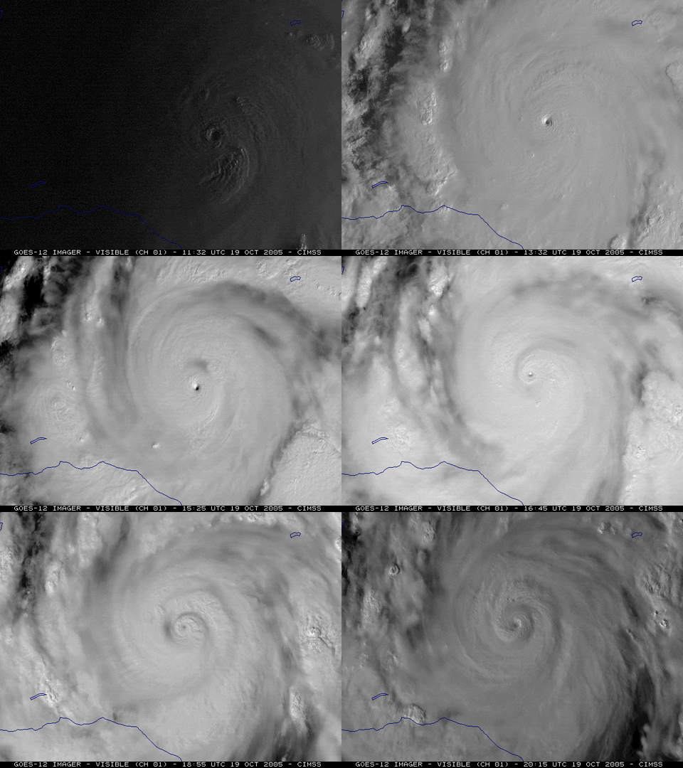
It's quite possible the center is performing some sort of trochoidal oscillation (similar to yesterday) embedded within the larger-scale NW flow. If that's the case, the short-term motion will take on a more eastward and northward component later today. The recent dip to the south would support this theory, however, by no means am I sure this is happening. The longer this westerly motion lasts (say a 3-5 more hours), the more unlikely it is that this is part of a trochoidal oscillation.

Edit: For those wondering what a trochoidal oscillation looks like in a TC, here is a classic example from Hurricane Wilma (2005):

Image
Last edited by SouthDadeFish on Sun Oct 02, 2016 8:59 am, edited 1 time in total.
6 likes   

User avatar
johngaltfla
Category 5
Category 5
Posts: 2069
Joined: Sun Jul 10, 2005 9:17 pm
Location: Sarasota County, FL
Contact:

Re: ATL: MATTHEW - Hurricane - Discussion

#3359 Postby johngaltfla » Sun Oct 02, 2016 8:58 am

KWT wrote:Well if it carries on that WNW/NW motion for much longer then Matthew isn't going to be joining that list of cat-4s hitting Haiti as it will miss it to the west.

NHC going to have to shift a little west again with this, even if the reasoning stays the same.


If that confirms that could be worse for the Carolinas. Let's hope that it doesn't move too far west.
0 likes   

stormreader

Re: ATL: MATTHEW - Hurricane - Discussion

#3360 Postby stormreader » Sun Oct 02, 2016 8:58 am

pgoss11 wrote:
NDG wrote:Matthew still jogging westward, latest recon pass.

13:34:00Z 13.950N 74.567W 696.3 mb
(~ 20.56 inHg) 2,676 meters
(~ 8,780 feet) 945.2 mb
(~ 27.91 inHg


Matthew will soon cross 75W. Can't help but think the west trends continue today. While I personally don't think this will get into the GOM..it is possible landfall would be farther south down the SE coast.

But you see now the real possibility of an entrance into the extreme SE GOM near Key West and a run up the West Coast.
0 likes   


Return to “2016”

Who is online

Users browsing this forum: No registered users and 7 guests