ATL: MATTHEW - Post-Tropical - Discussion
Moderator: S2k Moderators
-
bob rulz
- Category 5

- Posts: 1711
- Age: 36
- Joined: Sat Jan 28, 2006 7:30 pm
- Location: Salt Lake City, Utah
Re: ATL: MATTHEW - Hurricane - Discussion
A bit surprised that the NHC maintained 155mph at 8am. I know they're waiting on recon, but it seems to be clearly weaker than before. It's a shame it reached its peak during night-time. Then again, it's not as if maintaining the intensity is affecting anybody right at this particular moment.
0 likes

Re: ATL: MATTHEW - Hurricane - Discussion
Looks like a hot tower fired on the north eyewall.
Still seeing a good radial pattern of gravity waves on the cirrus.
Still seeing a good radial pattern of gravity waves on the cirrus.
0 likes
Re: ATL: MATTHEW - Hurricane - Discussion
Pressure remains pretty low at 944 mb as per the latest dropsonde, but I guess the wind speed has weakened some due to the ongoing ERC.
0 likes
Personal Forecast Disclaimer:
The posts in this forum are NOT official forecast and should not be used as such. They are just the opinion of the poster and may or may not be backed by sound meteorological data. They are NOT endorsed by any professional institution or storm2k.org. For official information, please refer to RSMC and NWS products.
The posts in this forum are NOT official forecast and should not be used as such. They are just the opinion of the poster and may or may not be backed by sound meteorological data. They are NOT endorsed by any professional institution or storm2k.org. For official information, please refer to RSMC and NWS products.
-
Hypercane_Kyle

- Category 5
- Posts: 3465
- Joined: Sat Mar 07, 2015 7:58 pm
- Location: Cape Canaveral, FL
Re: ATL: MATTHEW - Hurricane - Discussion
bob rulz wrote:A bit surprised that the NHC maintained 155mph at 8am. I know they're waiting on recon, but it seems to be clearly weaker than before. It's a shame it reached its peak during night-time. Then again, it's not as if maintaining the intensity is affecting anybody right at this particular moment.
Hate to say it but there's likely another shot at Cat 5 as the storm nears Jamaica/Cuba.
0 likes
My posts are my own personal opinion, defer to the National Hurricane Center (NHC) and other NOAA products for decision making during hurricane season.
-
hurricanehunter69
- Category 1

- Posts: 344
- Joined: Sun May 16, 2010 5:21 pm
- Location: New Orleans
Re: ATL: MATTHEW - Hurricane - Discussion
Staring at this water vapor loop is making me wonder if this outlier scenario could actually play out? http://www.ssd.noaa.gov/goes/comp/ceus/flash-wv.html #1) Matthew pumps up ridging; offsetting the low to mid level ridge in the western Atlantic weakening? #2) The trough in the gulf fails to materialize and or much weaker. #3) Ridging over western Mexico bridges over the gulf ?
0 likes
Re: ATL: MATTHEW - Hurricane - Discussion
Core is still hot at 9C
Pinhole eye
Product: Air Force Vortex Message (URNT12 KNHC)
Transmitted: 1st day of the month at 12:29Z
B. Center Fix Coordinates: 13°22'N 73°06'W (13.3667N 73.1W)
I. Maximum Flight Level Temp & Pressure Altitude Outside Eye: 12°C (54°F) at a pressure alt. of 3,046m (9,993ft)
J. Maximum Flight Level Temp & Pressure Altitude Inside Eye: 21°C (70°F) at a pressure alt. of 3,051m (10,010ft)
L. Eye Character: Closed
M. Eye Shape: Elliptical (oval shaped)
M. Orientation of Major Axis in Elliptical Eye: 50° to 230° (NE to SW)
M. Length of Major Axis in Elliptical Eye: 10 nautical miles
M. Length of Minor Axis in Elliptical Eye: 6 nautical miles
0 likes


Re: ATL: MATTHEW - Hurricane - Discussion
Raw T numbers down a bit, he's weakened some since last night.

UW - CIMSS
ADVANCED DVORAK TECHNIQUE
ADT-Version 8.2.1
Tropical Cyclone Intensity Algorithm
----- Current Analysis -----
Date : 01 OCT 2016 Time : 114500 UTC
Lat : 14:08:16 N Lon : 73:49:43 W
CI# /Pressure/ Vmax
6.9 / 926.0mb/137.4kt
Final T# Adj T# Raw T#
6.6 6.2 5.4
Center Temp : -52.5C Cloud Region Temp : -64.9C
Scene Type : EMBEDDED CENTER CLOUD REGION
Positioning Method : SPIRAL ANALYSIS
Ocean Basin : ATLANTIC
Dvorak CI > MSLP Conversion Used : CKZ Method
0 likes
The above post and any post by Ntxw is NOT an official forecast and should not be used as such. It is just the opinion of the poster and may or may not be backed by sound meteorological data. It is NOT endorsed by any professional institution including Storm2k. For official information, please refer to NWS products.
Help support Storm2K!

Re: ATL: MATTHEW - Hurricane - Discussion
Maximum sustained winds have probably decreased to 115 knots as per the latest recon pass.
0 likes
Personal Forecast Disclaimer:
The posts in this forum are NOT official forecast and should not be used as such. They are just the opinion of the poster and may or may not be backed by sound meteorological data. They are NOT endorsed by any professional institution or storm2k.org. For official information, please refer to RSMC and NWS products.
The posts in this forum are NOT official forecast and should not be used as such. They are just the opinion of the poster and may or may not be backed by sound meteorological data. They are NOT endorsed by any professional institution or storm2k.org. For official information, please refer to RSMC and NWS products.
-
chris_fit

- Category 5
- Posts: 3261
- Age: 43
- Joined: Wed Sep 10, 2003 11:58 pm
- Location: Tampa Bay Area, FL
Re: ATL: MATTHEW - Hurricane - Discussion
Latest recon pass also shows what appears to be a S component to Matthew's Westerly movement.
0 likes
Re: ATL: MATTHEW - Hurricane - Discussion
NotoSans wrote:Maximum sustained winds have probably decreased to 115 knots as per the latest recon pass.
No sign of a north turn either.
0 likes
-
wxman57

- Moderator-Pro Met

- Posts: 23175
- Age: 68
- Joined: Sat Jun 21, 2003 8:06 pm
- Location: Houston, TX (southwest)
Re: ATL: MATTHEW - Hurricane - Discussion
chris_fit wrote:Latest recon pass also shows what appears to be a S component to Matthew's Westerly movement.
You can't be sure that each vortex report caught the center of the eye, so it's difficult to determine storm movement over a short period of time using recon fixes. Satellite isn't indicating any south of west movement any longer.
1 likes
Re: ATL: MATTHEW - Hurricane - Discussion
The winds aren't there yet for a weaker storm to feel the pull

Now if it was still cat 5

Now if it was still cat 5
0 likes
-
chris_fit
- Category 5
- Posts: 3261
- Age: 43
- Joined: Wed Sep 10, 2003 11:58 pm
- Location: Tampa Bay Area, FL
Re: ATL: MATTHEW - Hurricane - Discussion
wxman57 wrote:chris_fit wrote:Latest recon pass also shows what appears to be a S component to Matthew's Westerly movement.
You can't be sure that each vortex report caught the center of the eye, so it's difficult to determine storm movement over a short period of time using recon fixes. Satellite isn't indicating any south of west movement any longer.
Thank you sir. I was under the thought that why look at Satellite when we have recon out there - but you have a valid point.
0 likes
Re: ATL: MATTHEW - Hurricane - Discussion
Miami Storm Tracker wrote:Miami Storm Tracker wrote:
Good Evening everyone,
Reposting this in the hope of getting any of the Pro Mets in here opinion.
I was just on the models page to see the GFS run. It seems another slight shift west, at some point I need to make some serious choices. So if any of the Pro Mets care to give me their take it would be very much appreciated. I am at my house in Key Largo for the weekend, I am stuck deciding do I put up the shutters or not. I have the boat hanging on the Davits do I put it on the trailer and pick up everything this weekend. If for some strange reason it decides to come further west than expected, I will not be able to get back in the Keys to do anything. I guess what I am hoping to get here is your feelings as to how serious a chance this could move in here and cause severe weather. Thanks in advance for yo Professional input.
You answered your own question. If you can't get back to secure things, do it now before you leave.
0 likes
Opinions expressed by this poster are purely conjecture on his part and have no basis in reality. As such, taking any advice from me would be foolish, and potentially deadly.
Re: ATL: MATTHEW - Hurricane - Discussion
To me, it looks like still headed due west.
Big tell will be when it gets past 74W.

Big tell will be when it gets past 74W.
0 likes
-
otowntiger
- Category 5
- Posts: 1932
- Joined: Tue Aug 31, 2004 7:06 pm
Re: ATL: MATTHEW - Hurricane - Discussion
Alyono wrote:bob rulz wrote:Weakening all the way to a category 2? What factors are leading you to believe such a dramatic weakening?
eyewall replacement and shear
but by tomorrow afternoon, incredibly favorable conditions are expected. I would not be the least bit surprised if we see explosive intensification starting late tomorrow and early Monday (yesterday, we only saw rapid intensification)
Well that's not good. For the sake of Jamaica, Cuba and Haiti I hope the doesn't happen.
0 likes
-
MGC

- S2K Supporter

- Posts: 5941
- Joined: Sun Mar 23, 2003 9:05 pm
- Location: Pass Christian MS, or what is left.
Re: ATL: MATTHEW - Hurricane - Discussion
Matthew's movement looks almost due west to me this morning. Matthew's satellite appearance has degraded some this morning. The NW quad of the hurricane looks to be impacted by some shear. Also, an elliptical eye was reported by recon. I can't recall such a powerful hurricane to have an elliptical eye. Key to watch will be Matthew's forward speed.....slower means a turn is more likely. Matthew should start making some northward progress later today....I doubt the track shift westward......MGC
1 likes
-
northjaxpro

- S2K Supporter
- Posts: 8900
- Joined: Mon Sep 27, 2010 11:21 am
- Location: Jacksonville, FL
Re: ATL: MATTHEW - Hurricane - Discussion
Steering
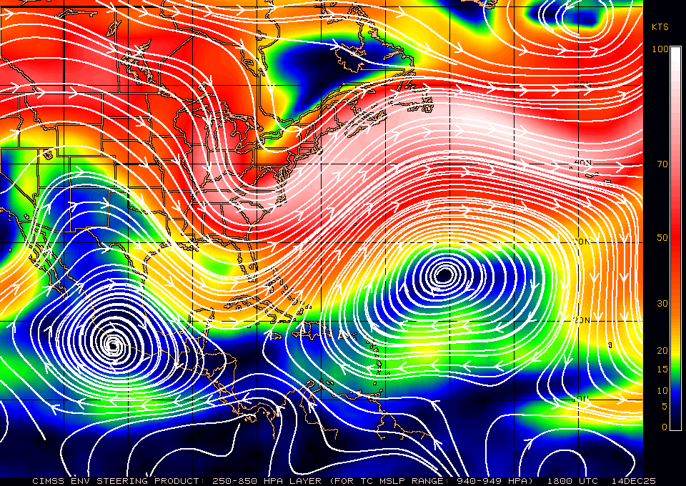
You can see the very western extent (nose of the ridge) extends to the western edge of Cuba. If the trough in the GOM does not did deeper, it is possible the ridge may hold and keep Matthew moving a bit farther west just a bit longer.
You can see the very western extent (nose of the ridge) extends to the western edge of Cuba. If the trough in the GOM does not did deeper, it is possible the ridge may hold and keep Matthew moving a bit farther west just a bit longer.
0 likes
NEVER, EVER SAY NEVER in the tropics and weather in general, and most importantly, with life itself!!
________________________________________________________________________________________
Fay 2008 Beryl 2012 Debby 2012 Colin 2016 Hermine 2016 Julia 2016 Matthew 2016 Irma 2017 Dorian 2019
________________________________________________________________________________________
Fay 2008 Beryl 2012 Debby 2012 Colin 2016 Hermine 2016 Julia 2016 Matthew 2016 Irma 2017 Dorian 2019
-
northjaxpro
- S2K Supporter
- Posts: 8900
- Joined: Mon Sep 27, 2010 11:21 am
- Location: Jacksonville, FL
Re: ATL: MATTHEW - Hurricane - Discussion
northjaxpro wrote:Steering
You can see the very western extent (nose of the ridge) extends to the western edge of Cuba. If the trough in the GOM does not did deeper to help erode that ridge further, it is possible the ridge may hold and keep Matthew moving a bit farther west just a bit longer.
0 likes
NEVER, EVER SAY NEVER in the tropics and weather in general, and most importantly, with life itself!!
________________________________________________________________________________________
Fay 2008 Beryl 2012 Debby 2012 Colin 2016 Hermine 2016 Julia 2016 Matthew 2016 Irma 2017 Dorian 2019
________________________________________________________________________________________
Fay 2008 Beryl 2012 Debby 2012 Colin 2016 Hermine 2016 Julia 2016 Matthew 2016 Irma 2017 Dorian 2019
Who is online
Users browsing this forum: No registered users and 71 guests