ATL: MATTHEW - Post-Tropical - Discussion
Moderator: S2k Moderators

Re: ATL: MATTHEW - Hurricane - Discussion
Matthew down to 155 as per latest advisory, citing the eye being less distinct--wouldn't it be ironic if the plane got there and found it even stronger given the thickness of the convection.
0 likes
The above post is not official and should not be used as such. It is the opinion of the poster and may or may not be backed by sound meteorological data. It is not endorsed by any professional institution or storm2k.org. For official information, please refer to the NHC and NWS products.
-
brunota2003

- S2K Supporter

- Posts: 9476
- Age: 35
- Joined: Sat Jul 30, 2005 9:56 pm
- Location: Stanton, KY...formerly Havelock, NC
- Contact:
Re: ATL: MATTHEW - Hurricane - Discussion
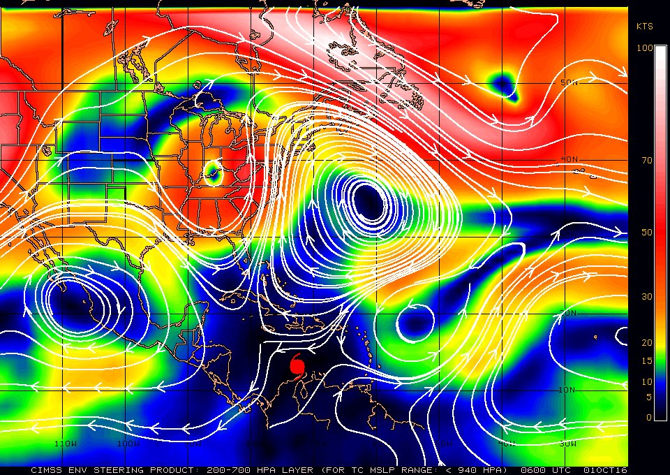
Here is the latest steering current chart. Not really seeing much to force a WNW/NW/N turn, at least not in the near term?
1 likes
Just a small town southern boy helping other humans.
-
SapphireSea
- Category 1

- Posts: 430
- Joined: Wed Aug 24, 2005 12:13 pm
- Location: Miami, FL
Re: ATL: MATTHEW - Hurricane - Discussion
brunota2003 wrote:Here is the latest steering current chart. Not really seeing much to force a WNW/NW/N turn, at least not in the near term?
That would be true if the steering would stay static. Thus far the forecast models are seeing is for the Bermuda High to retreat a little and the trough over Kentucky to shift a bit more east as it progresses. That will make those steering lines going N to shift east and turn the storm in the next 8-20 hours. There will be somewhat of a momentum / speed factor to turning it, of which of its effects remains to be seen. Next 36 hours will show the key and trivialize the rest of the forecast.
0 likes

Re: ATL: MATTHEW - Hurricane - Discussion
I don't know if there may be something wrong with AMSU's Microwave Sounder, or if the data is correct, or perhaps the algorithm is off; but the analyzed core is extremely high up in the troposphere. Also, a lot cooler than recon's measurements. Here is the latest chart time stamped about 7 hrs ago.

0 likes
Re: ATL: MATTHEW - Hurricane - Discussion
The eye appears to be becoming cloud-filled. Not sure if the weakening is due to ERC or induced by shear.
0 likes
Personal Forecast Disclaimer:
The posts in this forum are NOT official forecast and should not be used as such. They are just the opinion of the poster and may or may not be backed by sound meteorological data. They are NOT endorsed by any professional institution or storm2k.org. For official information, please refer to RSMC and NWS products.
The posts in this forum are NOT official forecast and should not be used as such. They are just the opinion of the poster and may or may not be backed by sound meteorological data. They are NOT endorsed by any professional institution or storm2k.org. For official information, please refer to RSMC and NWS products.
-
brunota2003
- S2K Supporter
- Posts: 9476
- Age: 35
- Joined: Sat Jul 30, 2005 9:56 pm
- Location: Stanton, KY...formerly Havelock, NC
- Contact:
Re: ATL: MATTHEW - Hurricane - Discussion
SapphireSea wrote:brunota2003 wrote:Here is the latest steering current chart. Not really seeing much to force a WNW/NW/N turn, at least not in the near term?
That would be true if the steering would stay static. Thus far the forecast models are seeing is for the Bermuda High to retreat a little and the trough over Kentucky to shift a bit more east as it progresses. That will make those steering lines going N to shift east and turn the storm in the next 8-20 hours. There will be somewhat of a momentum / speed factor to turning it, of which of its effects remains to be seen. Next 36 hours will show the key and trivialize the rest of the forecast.
I know, but they were already showing it moving to the WNW in ~12 hours. I just don't see that (hence why I said near term). Even looking at the cirrus outflow, it isn't flattening and the storm isn't taking on a shape showing it may begin a turn soon. Now, give it 18-24 hours and we may begin to see a turn.
0 likes
Just a small town southern boy helping other humans.
Re: ATL: MATTHEW - Hurricane - Discussion
Feeder band building on the southern half of Matthew.
http://tropic.ssec.wisc.edu/real-time/m ... splay.html
Likely the setup IMHO for the much discussed EWRC - maybe later this afternoon.
http://tropic.ssec.wisc.edu/real-time/m ... splay.html
Likely the setup IMHO for the much discussed EWRC - maybe later this afternoon.
0 likes
Re: ATL: MATTHEW - Hurricane - Discussion
NotoSans wrote:The eye appears to be becoming cloud-filled. Not sure if the weakening is due to ERC or induced by shear.
I think Matthew is starting to tilt a little.
It may be feeling the effects of the trough.
0 likes
-
SapphireSea
- Category 1
- Posts: 430
- Joined: Wed Aug 24, 2005 12:13 pm
- Location: Miami, FL
Re: ATL: MATTHEW - Hurricane - Discussion
GCANE wrote:I don't know if there may be something wrong with AMSU's Microwave Sounder, or if the data is correct, or perhaps the algorithm is off; but the analyzed core is extremely high up in the troposphere. Also, a lot cooler than recon's measurements. Here is the latest chart time stamped about 7 hrs ago.
Looks to show a positive temp anomaly which would indicate the warm core. Looks fine to me. Extends from upper all the way down to its depth on surface.
1 likes
Re: ATL: MATTHEW - Hurricane - Discussion
BULLETIN
HURRICANE MATTHEW ADVISORY NUMBER 13
NWS NATIONAL HURRICANE CENTER MIAMI FL AL142016
500 AM EDT SAT OCT 01 2016
...MATTHEW WEAKENS SLIGHTLY AND IS NOW A CATEGORY 4 HURRICANE...
HURRICANE MATTHEW ADVISORY NUMBER 13
NWS NATIONAL HURRICANE CENTER MIAMI FL AL142016
500 AM EDT SAT OCT 01 2016
...MATTHEW WEAKENS SLIGHTLY AND IS NOW A CATEGORY 4 HURRICANE...
0 likes
Personal Forecast Disclaimer:
The posts in this forum are NOT official forecast and should not be used as such. They are just the opinion of the poster and may or may not be backed by sound meteorological data. They are NOT endorsed by any professional institution or storm2k.org. For official information, please refer to the NHC and NWS products.
The posts in this forum are NOT official forecast and should not be used as such. They are just the opinion of the poster and may or may not be backed by sound meteorological data. They are NOT endorsed by any professional institution or storm2k.org. For official information, please refer to the NHC and NWS products.
-
SapphireSea
- Category 1
- Posts: 430
- Joined: Wed Aug 24, 2005 12:13 pm
- Location: Miami, FL
Re: ATL: MATTHEW - Hurricane - Discussion
GCANE wrote:NotoSans wrote:The eye appears to be becoming cloud-filled. Not sure if the weakening is due to ERC or induced by shear.
I think Matthew is starting to tilt a little.
It may be feeling the effects of the trough.
Could be an illusion. I looked at some WV images and it seems the Kentucky low is beggining to lift out and the trough is washing out instead of cutting off. Could be a bit of a game changer. Need to see those next 8 hours.
0 likes
-
hurricanes1234
- Category 5

- Posts: 2908
- Joined: Sat Jul 28, 2012 6:19 pm
- Location: Trinidad and Tobago
Re: ATL: MATTHEW - Hurricane - Discussion
Absolutely stunned by this storm! Even though it's weakened a bit, it's still very very powerful. Incredible that this suddenly broke the streak of no category 5s.

0 likes
PLEASE NOTE: With the exception of information from weather agencies that I may copy and paste here, my posts will NEVER be official, since I am NOT a meteorologist. They are solely my amateur opinion, and may or may not be accurate. Therefore, please DO NOT use them as official details, particularly when making important decisions. Thank you.
Re: ATL: MATTHEW - Hurricane - Discussion
Here is the 250mb winds.
Matt is coming up to the NW side of the anticyclone and is starting to get hit from the winds being driven by the Midwest Low and the Baja High.
I think we have seen Matt's peak intensity.

Matt is coming up to the NW side of the anticyclone and is starting to get hit from the winds being driven by the Midwest Low and the Baja High.
I think we have seen Matt's peak intensity.
0 likes
Re: ATL: MATTHEW - Hurricane - Discussion
Just checked 200mb vort and it does look like it is a bit south of the lower-level circulations.

0 likes
Re: ATL: MATTHEW - Hurricane - Discussion
I thought this was a cool illustration.
Winds are at the surface and shading indicates CAPE.
To me, this looks like Matt is pulling heat out of the ocean due to WISHE (Wind Induced Surface Heat Exchange) almost entirely from its east side and then entraining it.

Winds are at the surface and shading indicates CAPE.
To me, this looks like Matt is pulling heat out of the ocean due to WISHE (Wind Induced Surface Heat Exchange) almost entirely from its east side and then entraining it.
0 likes

Re: ATL: MATTHEW - Hurricane - Discussion
Interesting that the Cuban mets have it landfalling there slightly west of the NHC forecast track....
http://www.met.inf.cu/asp/genesis.asp?T ... .jpg&TB3=0
http://www.met.inf.cu/asp/genesis.asp?T ... .jpg&TB3=0
0 likes

Re: ATL: MATTHEW - Hurricane - Discussion
Something interesting: Matthew's the southernmost Category 5 in the Atlantic.
2 likes
Igor 2010, Sandy 2012, Fay 2014, Gonzalo 2014, Joaquin 2015, Nicole 2016, Humberto 2019, Imelda 2025
I am only a tropical weather enthusiast. My predictions are not official and may or may not be backed by sound meteorological data. For official information, please refer to the NHC and NWS products.
I am only a tropical weather enthusiast. My predictions are not official and may or may not be backed by sound meteorological data. For official information, please refer to the NHC and NWS products.
Re: ATL: MATTHEW - Hurricane - Discussion
Pretty high rain-rate for the cell to the east along 70W.
Wondering if this may contribute to tilt and / or shear due to the fact it may position the anti-cyclone more over it.

Wondering if this may contribute to tilt and / or shear due to the fact it may position the anti-cyclone more over it.
0 likes
-
cycloneye

- Admin

- Posts: 149647
- Age: 69
- Joined: Thu Oct 10, 2002 10:54 am
- Location: San Juan, Puerto Rico
Re: ATL: MATTHEW - Hurricane - Discussion
0 likes
Visit the Caribbean-Central America Weather Thread where you can find at first post web cams,radars
and observations from Caribbean basin members Click Here
and observations from Caribbean basin members Click Here
Who is online
Users browsing this forum: No registered users and 120 guests