ATL: COLIN - Post-Tropical - Discussion

Moderator: S2k Moderators

Message
Author
floridasun78
Category 5
Category 5
Posts: 3755
Joined: Sun May 17, 2009 10:16 pm
Location: miami fl

Re: ATL: INVEST 93L - Discussion

#221 Postby floridasun78 » Sat Jun 04, 2016 11:42 pm

HurricaneEric wrote:
Evil Jeremy wrote:
HurricaneEric wrote:Is it just me or does the system look much more disorganized than earlier? To my untrained eye I'd say it hasn't really progressed at all.


This will be a messy system for it's entire lifespan. Could get ugly once the front swoops it up. That said, it looks fine to me, considering it's still cooking. Looks to me like rotation is cranking up around 19.5N, 85W

Also, welcome to the forum!


Thanks for the welcome! Been a reader of these forums for a little over a year now haha.

floridasun78 wrote:
HurricaneEric wrote:
Probably in the form of wind gusts from the squalls, but nothing sustained I don't think. Also depends what you mean by South FL. Miami? Naples?

i saying in miami national weather office here telling us review our kit incase


In that case I'd say just wind gusts from the squalls then. Don't think we'll get any sustained TS force winds at all from this system.

EDIT: Although, yes you should be cautious still. Any valuable stuff you may have outdoors (like a pet for example) would be better off indoors in case of a tornado or really severe thunderstorm.

ok ty for detail i will be following all day Sunday see what happen
0 likes   

SeGaBob

Re: ATL: INVEST 93L - Models

#222 Postby SeGaBob » Sat Jun 04, 2016 11:44 pm

I hope the 0Z GEM run verifies, but it isn't a reliable model to me.
0 likes   

supercane
S2K Supporter
S2K Supporter
Posts: 2858
Joined: Wed Sep 16, 2009 8:27 pm

Re: ATL: INVEST 93L - Discussion

#223 Postby supercane » Sun Jun 05, 2016 12:19 am

TWO issued nearly an hour early:

ABNT20 KNHC 050503
TWOAT

TROPICAL WEATHER OUTLOOK
NWS NATIONAL HURRICANE CENTER MIAMI FL
200 AM EDT SUN JUN 5 2016

For the North Atlantic...Caribbean Sea and the Gulf of Mexico:

The National Hurricane Center has issued the last advisory on
post-tropical cyclone Bonnie, located a couple of hundred miles
north-northeast of Bermuda.

A broad area of low pressure is located near the eastern Yucatan
Peninsula, accompanied by a large area of showers and thunderstorms.
Conditions appear to be favorable for some development of this low
when it moves into the southern Gulf of Mexico later today. This
system is likely to become a tropical depression or a tropical storm
by tonight or on Monday while it moves north-northeastward toward
the Florida Peninsula. Regardless of development, locally heavy
rains and flooding are possible over portions of the Yucatan
Peninsula, western Cuba, the Florida Keys, and the Florida Peninsula
during the next few days. Interests in these areas should
monitor the progress of this system. An Air Force Reserve Hurricane
Hunter aircraft is scheduled to investigate the system later today.
* Formation chance through 48 hours...high...80 percent
* Formation chance through 5 days...high...80 percent

$$
Forecaster Pasch
0 likes   

stormwise

Re: ATL: INVEST 93L - Models

#224 Postby stormwise » Sun Jun 05, 2016 1:54 am

It will likely come down to where the actual mid-level ridge is placed the closer to the east it sits the more likely the low will nudge west then N up into the weakness.
Image
ukmet


Image


500 mb height rise is the reason i believe for the EC/CMC/UKMET shifting west in the track trend atm in the modeling. Needs recon data.

The posts in this forum are NOT official forecast and should not be used as such. They are just the opinion of the poster and may or may not be backed by sound meteorological data. They are NOT endorsed by any professional institution or storm2k.org. For official information, please refer to the NHC and NWS products.
0 likes   

User avatar
Recurve
Category 5
Category 5
Posts: 1640
Joined: Tue Aug 16, 2005 8:59 pm
Location: St. Petersburg, FL

Re: ATL: INVEST 93L - Discussion

#225 Postby Recurve » Sun Jun 05, 2016 3:54 am

Interesting that almost all of the thunderstorms bands have evaporated early this morning. They are being replaced by a few strong but isolated cells. In any case, whatever is going on is going to get slung into Florida, but it's not going to be very organized unless there's more concentrated convention and a true tropical low forms under it.

What concerns me most is the tornado possibility on Monday. During TS Mitch in South Florida, I almost drove into a tornado as I was coming home from work. I was a just a few minutes behind an 18-wheeler that got thrown across US1 and left its front axle in the highway.

In fact, in many years in Florida, the scariest situations I've been in have all been tropical storms -- partly because, of course, everyone went to work or wherever just like nothing was happening. Same with Irene. Everyone went to work, the stormy mess shifted eastward, and all of Dade and Broward fled home in the afternoon, getting people caught in nasty squalls and tornadoes on the roads.

Personal Forecast Disclaimer:
My posts are NOT official forecast and should not be viewed as such. They are just my opinion and are not backed by meteorological data. They are NOT endorsed by any professional institution or storm2k.org. For official information, please refer to the NHC and NWS products.
0 likes   

jlauderdal
S2K Supporter
S2K Supporter
Posts: 7182
Joined: Wed May 19, 2004 5:46 am
Location: NE Fort Lauderdale
Contact:

Re: ATL: INVEST 93L - Discussion

#226 Postby jlauderdal » Sun Jun 05, 2016 4:39 am

I posted on this yesterday and it continues to be the bigger threat down the road for southeast florida especially if the trop system can generate heavy rain mon-tues and moisten up the ground as it has been drive on the eastern side for over a week. North and west of the lake should be ok,,,depends where that boundry sets up. We have seen 8+ in these scenarios before.

AREA FORECAST DISCUSSION
NATIONAL WEATHER SERVICE MIAMI FL
448 AM EDT SUN JUN 5 2016

DISCUSSION

IT IS IMPORTANT TO REMEMBER THAT THE HEAVY RAIN THREAT FOR SOUTH
FLORIDA WILL CONTINUE THROUGH THE WEEK. WE MAY SEE SOME OF OUR
HEAVIEST RAINFALL LATER IN THE WEEK.
0 likes   

User avatar
cycloneye
Admin
Admin
Posts: 145295
Age: 68
Joined: Thu Oct 10, 2002 10:54 am
Location: San Juan, Puerto Rico

Re: ATL: INVEST 93L - Discussion

#227 Postby cycloneye » Sun Jun 05, 2016 5:22 am

Bouy 42056 located in Yucatan Channel has been getting good data in the past few hours.

http://www.ndbc.noaa.gov/station_page.php?station=42056
0 likes   
Visit the Caribbean-Central America Weather Thread where you can find at first post web cams,radars
and observations from Caribbean basin members Click Here

User avatar
NDG
S2K Supporter
S2K Supporter
Posts: 15446
Joined: Sun Jul 09, 2006 10:14 pm
Location: Orlando, FL

Re: ATL: INVEST 93L - Discussion

#228 Postby NDG » Sun Jun 05, 2016 5:50 am

Low pressure center appears to be over the NE tip of Yucatan Peninsula, Cancun is reporting light SE winds with a pressure of 1004 mb.
0 likes   

User avatar
Nimbus
Category 5
Category 5
Posts: 5300
Joined: Mon Jul 19, 2004 10:54 am

Re: ATL: INVEST 93L - Discussion

#229 Postby Nimbus » Sun Jun 05, 2016 5:56 am

LLC is probably partially exposed on the west side of the convection.
Don't know if it will try to reform under the convection or go inland over the Yucatan but the morning visible satellite loop should tell.
0 likes   

User avatar
johngaltfla
Category 5
Category 5
Posts: 2069
Joined: Sun Jul 10, 2005 9:17 pm
Location: Sarasota County, FL
Contact:

Re: ATL: INVEST 93L - Discussion

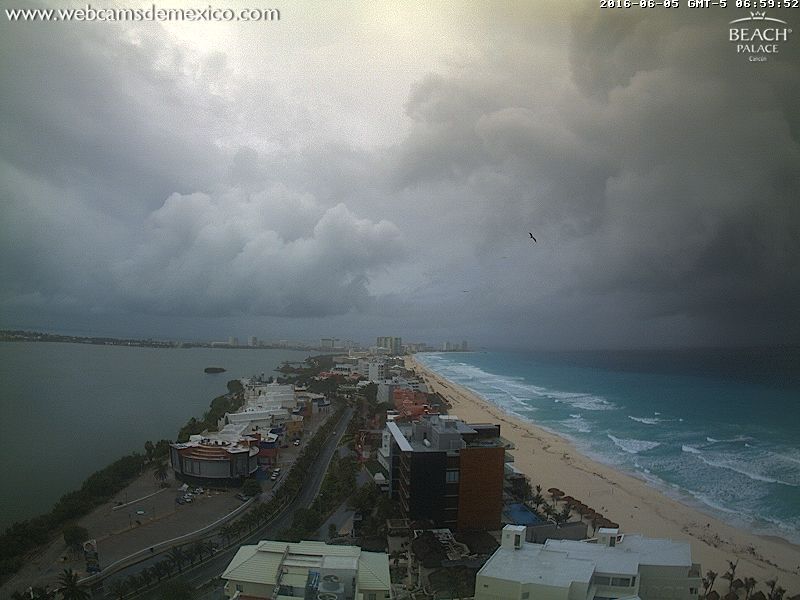
#230 Postby johngaltfla » Sun Jun 05, 2016 6:05 am

I think I'll need my galoshes on Monday and Tuesday. Ugh, is driving going to stink.

902
FXUS62 KTBW 050940
AFDTBW

AREA FORECAST DISCUSSION
NATIONAL WEATHER SERVICE TAMPA BAY RUSKIN FL
540 AM EDT SUN JUN 5 2016

SHORT TERM (TODAY-MONDAY)

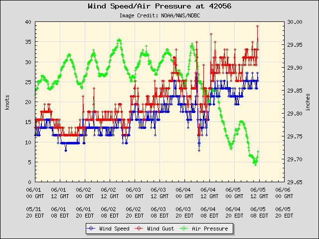
FOR TODAY THE LOW LEVEL SOUTHEAST TO SOUTH FLOW WILL CONTINUE TO
BRING DEEP TROPICAL MOISTURE, PRECIPITABLE WATER CLIMBING TO
AROUND 2 INCHES, INTO THE AREA. THIS CAN ALREADY BE SEEN OVER THE
EASTERN GULF WHERE A FEW SHOWERS AND STORMS ARE DEVELOPING AT THIS
TIME AND MOVING INTO LEVY COUNTY. WITH DAYTIME HEATING EXPECT TO
SEE MORE SCATTERED TO NUMEROUS SHOWERS AND THUNDERSTORMS DEVELOP
WITH THE HIGHEST POPS OVER THE INTERIOR COUNTIES THIS AFTERNOON
AND EARLY EVENING. HIGH TEMPERATURES TODAY WILL RANGE FROM THE MID
TO UPPER 80S CLOSE TO THE COAST TO THE LOWER 90S INLAND WITH HEAT
INDICES AROUND 100.

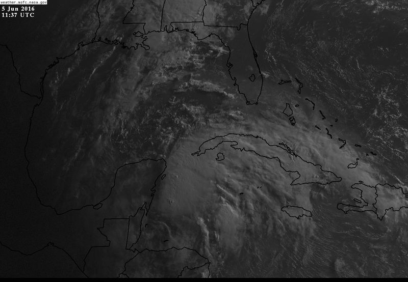
TONIGHT THROUGH MONDAY...THE AREA OF LOW PRESSURE NEAR THE
YUCATAN PENINSULA WILL CONTINUE TO MOVE NORTH ACROSS THE EASTERN
GULF OF MEXICO WITH THE POTENTIAL TO DEVELOP INTO A TROPICAL
SYSTEM. EITHER WAY IT STILL LOOKS LIKE THE MAIN IMPACTS TO OUR
AREA WILL BE HEAVY RAINFALL, INCREASING BREEZY CONDITIONS, AND
ISOLATED WATERSPOUTS/TORNADOES AS THE REGION WILL BE IN THE
FAVORED EASTERN SEMI-CIRCLE. THERE WILL ALSO BE AN INCREASING
THREAT FOR SOME COASTAL FLOODING, ESPECIALLY FROM AROUND TAMPA BAY
NORTHWARD, AS THE INCREASING SOUTHEAST FLOW BECOMES SOUTHERLY
DURING MONDAY AFTERNOON.

THE MAIN AREA OF SHOWERS AND A FEW THUNDERSTORMS WILL DEVELOP
FROM SOUTHWEST TO NORTHEAST ACROSS THE AREA LATE TONIGHT INTO
MONDAY MORNING AND CONTINUE THROUGH THE DAY. BASED ON LATEST
FORECAST TRACKS WIDESPREAD RAINFALL AMOUNTS OF 3 TO 6 INCHES
APPEAR LIKELY, ESPECIALLY FROM AROUND THE TAMPA BAY AREA
NORTHWARD ACROSS THE NATURE COAST. ALSO AT THIS TIME, WINDS ARE
FORECAST TO INCREASE TO BETWEEN 20 AND 30 MPH MONDAY AFTERNOON
NEAR THE COAST WITH SOME HIGHER GUSTS, WHILE INLAND AREAS SHOULD
GENERALLY REMAIN BETWEEN 15 AND 20 MPH WITH AN OCCASIONAL HIGHER
GUST, BUT THIS ALL DEPENDS ON THE STRENGTH AND EVENTUAL TRACK OF
THE LOW. NO MATTER WHAT THOUGH SOME OF THE STRONGER SHOWERS AND
THUNDERSTORMS COULD PRODUCE BRIEF STRONG GUSTY WINDS.

IT WILL REMAIN WARM AND MUGGY WITH LOW TEMPERATURES TONIGHT A FEW
DEGREES ABOVE NORMAL IN THE MID TO UPPER 70S WITH DAYTIME HIGHS ON
MONDAY EXPECTED TO BE BELOW NORMAL IN THE LOWER TO MID 80S THANKS
TO THE ABUNDANT CLOUDS AND RAINFALL.
0 likes   

tolakram
Admin
Admin
Posts: 20009
Age: 62
Joined: Sun Aug 27, 2006 8:23 pm
Location: Florence, KY (name is Mark)

Re: ATL: INVEST 93L - Discussion

#231 Postby tolakram » Sun Jun 05, 2016 6:23 am

0 likes   
M a r k
- - - - -
Join us in chat: Storm2K Chatroom Invite. Android and IOS apps also available.

The posts in this forum are NOT official forecasts and should not be used as such. Posts are NOT endorsed by any professional institution or STORM2K.org. For official information and forecasts, please refer to NHC and NWS products.

User avatar
gatorcane
S2K Supporter
S2K Supporter
Posts: 23691
Age: 47
Joined: Sun Mar 13, 2005 3:54 pm
Location: Boca Raton, FL

Re: ATL: INVEST 93L - Discussion

#232 Postby gatorcane » Sun Jun 05, 2016 6:33 am

Wow that is some deep convection, shear is really dropping over the eastern Yucatan area too:

Image
0 likes   

User avatar
NDG
S2K Supporter
S2K Supporter
Posts: 15446
Joined: Sun Jul 09, 2006 10:14 pm
Location: Orlando, FL

Re: ATL: INVEST 93L - Discussion

#233 Postby NDG » Sun Jun 05, 2016 6:38 am

Buoy 42056 reported a wind gust of 39 knots a few minutes ago, if the recon is able to find a well defined LLC this afternoon, 93L will go straight to tropical storm.

Image
0 likes   

User avatar
cycloneye
Admin
Admin
Posts: 145295
Age: 68
Joined: Thu Oct 10, 2002 10:54 am
Location: San Juan, Puerto Rico

Re: ATL: INVEST 93L - Discussion

#234 Postby cycloneye » Sun Jun 05, 2016 6:42 am

Up to 90%-90%

TROPICAL WEATHER OUTLOOK
NWS NATIONAL HURRICANE CENTER MIAMI FL
800 AM EDT SUN JUN 5 2016

For the North Atlantic...Caribbean Sea and the Gulf of Mexico:

A low pressure area located near the northeastern portion of the
Yucatan Peninsula is producing a large area of showers and
thunderstorms over the northwestern Caribbean Sea and western Cuba.
Surface data show that pressures are falling in the area, and that
winds to near tropical storm force are occurring over the
northwestern Caribbean Sea. Environmental conditions are expected to
be favorable for additional development, and this system is likely
to become a tropical depression or a tropical storm by tonight or on
Monday while it moves north-northeastward toward the Florida
Peninsula.

Regardless of development, locally heavy rains and flooding are
possible over portions of the Yucatan Peninsula, western Cuba, the
Florida Keys, and the Florida Peninsula during the next few days.
Interests in these areas should monitor the progress of this
system. Tropical storm conditions could occur along a portion
of the west coast of the Florida Peninsula as early as Monday
afternoon. An Air Force Reserve Hurricane Hunter aircraft is
scheduled to investigate the low later today.
* Formation chance through 48 hours...high...90 percent
* Formation chance through 5 days...high...90 percent

&&
High Seas Forecasts can be found under AWIPS header NFDHSFAT1 and
WMO header FZNT01 KWBC.

$$
Forecaster Brown
0 likes   
Visit the Caribbean-Central America Weather Thread where you can find at first post web cams,radars
and observations from Caribbean basin members Click Here

User avatar
gatorcane
S2K Supporter
S2K Supporter
Posts: 23691
Age: 47
Joined: Sun Mar 13, 2005 3:54 pm
Location: Boca Raton, FL

Re: ATL: INVEST 93L - Discussion

#235 Postby gatorcane » Sun Jun 05, 2016 6:44 am

NDG you are right. NHC mentions the tropical storm force winds occurring already
0 likes   

User avatar
NDG
S2K Supporter
S2K Supporter
Posts: 15446
Joined: Sun Jul 09, 2006 10:14 pm
Location: Orlando, FL

Re: ATL: INVEST 93L - Discussion

#236 Postby NDG » Sun Jun 05, 2016 6:51 am

cycloneye wrote:Up to 90%-90%

TROPICAL WEATHER OUTLOOK
NWS NATIONAL HURRICANE CENTER MIAMI FL
800 AM EDT SUN JUN 5 2016

For the North Atlantic...Caribbean Sea and the Gulf of Mexico:

A low pressure area located near the northeastern portion of the
Yucatan Peninsula is producing a large area of showers and
thunderstorms over the northwestern Caribbean Sea and western Cuba.
Surface data show that pressures are falling in the area, and that
winds to near tropical storm force are occurring over the
northwestern Caribbean Sea. Environmental conditions are expected to
be favorable for additional development, and this system is likely
to become a tropical depression or a tropical storm by tonight or on
Monday while it moves north-northeastward toward the Florida
Peninsula.

Regardless of development, locally heavy rains and flooding are
possible over portions of the Yucatan Peninsula, western Cuba, the
Florida Keys, and the Florida Peninsula during the next few days.
Interests in these areas should monitor the progress of this
system. Tropical storm conditions could occur along a portion
of the west coast of the Florida Peninsula as early as Monday
afternoon.
An Air Force Reserve Hurricane Hunter aircraft is
scheduled to investigate the low later today.
* Formation chance through 48 hours...high...90 percent
* Formation chance through 5 days...high...90 percent

&&
High Seas Forecasts can be found under AWIPS header NFDHSFAT1 and
WMO header FZNT01 KWBC.

$$
Forecaster Brown
0 likes   

User avatar
northjaxpro
S2K Supporter
S2K Supporter
Posts: 8900
Joined: Mon Sep 27, 2010 11:21 am
Location: Jacksonville, FL

Re: ATL: INVEST 93L - Discussion

#237 Postby northjaxpro » Sun Jun 05, 2016 6:52 am

That is the deepest convection to flare-up. Extremely impressive convective cloud tops as well. Plus, the convection has overall been sustaining for the past several hours. That is an indicator to me that at this moment, shear has relaxed and that the LLC may be finally coalescing near or just over the northeast tip of the Yucatan Peninsula. As NDG showed above, buoy reporting gusts already above tropical storm force. I think it will be a safe assumption to rationalize that there is an very good to excellent chance that Recon will find a closed off LLC. Also, I think they will find that Colin had been born as well.
0 likes   
NEVER, EVER SAY NEVER in the tropics and weather in general, and most importantly, with life itself!!

________________________________________________________________________________________

Fay 2008 Beryl 2012 Debby 2012 Colin 2016 Hermine 2016 Julia 2016 Matthew 2016 Irma 2017 Dorian 2019

User avatar
NDG
S2K Supporter
S2K Supporter
Posts: 15446
Joined: Sun Jul 09, 2006 10:14 pm
Location: Orlando, FL

Re: ATL: INVEST 93L - Discussion-8 AM EDT TWO=Up to 90%-90%

#238 Postby NDG » Sun Jun 05, 2016 7:05 am

Looking north in Cancun, mean looking clouds on the right side over the Caribbean.

Image
0 likes   

User avatar
gigabite
S2K Supporter
S2K Supporter
Posts: 916
Age: 72
Joined: Wed May 05, 2004 4:09 pm
Location: Naples, Florida

Re: ATL: INVEST 93L - Discussion-8 AM EDT TWO=Up to 90%-90%

#239 Postby gigabite » Sun Jun 05, 2016 7:07 am

Image
The New Moon passes just under this 16,000 +/- ton mass of water vapor at around 1:20 this afternoon.
Last edited by gigabite on Sun Jun 05, 2016 7:16 am, edited 1 time in total.
0 likes   

User avatar
NDG
S2K Supporter
S2K Supporter
Posts: 15446
Joined: Sun Jul 09, 2006 10:14 pm
Location: Orlando, FL

Re: ATL: INVEST 93L - Discussion-8 AM EDT TWO=Up to 90%-90%

#240 Postby NDG » Sun Jun 05, 2016 7:16 am

Fairly big system, but the surface low is on the NW edge of the deep convection, still suffering from some shear.

Image
0 likes   


Return to “2016”

Who is online

Users browsing this forum: No registered users and 5 guests