ATL: GASTON - Post-Tropical - Discussion

Moderator: S2k Moderators

Message
Author
User avatar
Kazmit
Category 5
Category 5
Posts: 2124
Age: 22
Joined: Mon Jul 25, 2016 8:49 am
Location: Williamsburg, VA / Bermuda

Re: ATL: INVEST 90L - Models

#161 Postby Kazmit » Mon Aug 22, 2016 3:59 pm

CrazyC83 wrote:What are the SST's east of Bermuda? A bit farther west and this could be their worst storm in recorded history...

Also, I'd really watch this into Newfoundland at the end of the line. That GFS wants to place a 920mb storm not far off Cape Race, which would be much larger and deeper than Igor. It doesn't seem realistic, but who knows.

Just east of Bermuda would be about 83-86 degrees Fahrenheit. Quite warm indeed.
0 likes   
Igor 2010, Sandy 2012, Fay 2014, Gonzalo 2014, Joaquin 2015, Nicole 2016, Humberto 2019

I am only a tropical weather enthusiast. My predictions are not official and may or may not be backed by sound meteorological data. For official information, please refer to the NHC and NWS products.

CrazyC83
Professional-Met
Professional-Met
Posts: 34002
Joined: Tue Mar 07, 2006 11:57 pm
Location: Deep South, for the first time!

Re: ATL: SEVEN - Tropical Depression - Discussion

#162 Postby CrazyC83 » Mon Aug 22, 2016 4:07 pm

gatorcane wrote:interesting that NHC is actually slightly decreasing the intensity on days 4 and 5 due to shear despite global model guidance.


I'm a bit surprised too, but I do think this could be a major hurricane well before then.
0 likes   

User avatar
abajan
S2K Supporter
S2K Supporter
Posts: 4230
Joined: Sun Sep 07, 2003 5:10 am
Location: Barbados

Re: ATL: SEVEN - Tropical Depression - Discussion

#163 Postby abajan » Mon Aug 22, 2016 4:25 pm

Pretty healthy looking. And according to the NHC's discussion, they expect it to become a hurricane in less than two days time.
1 likes   

User avatar
Hammy
Category 5
Category 5
Posts: 5849
Age: 41
Joined: Fri May 25, 2012 5:25 pm
Contact:

Re: ATL: SEVEN - Tropical Depression - Discussion

#164 Postby Hammy » Mon Aug 22, 2016 4:42 pm

CrazyC83 wrote:
gatorcane wrote:interesting that NHC is actually slightly decreasing the intensity on days 4 and 5 due to shear despite global model guidance.


I'm a bit surprised too, but I do think this could be a major hurricane well before then.


I was surprised as well and checked the models after. The GFS/Euro from earlier did show brief weakening around the 96-120 hour period--the explosive intensification isn't until after 120 hours.
1 likes   
The above post is not official and should not be used as such. It is the opinion of the poster and may or may not be backed by sound meteorological data. It is not endorsed by any professional institution or storm2k.org. For official information, please refer to the NHC and NWS products.

User avatar
NDG
S2K Supporter
S2K Supporter
Posts: 15446
Joined: Sun Jul 09, 2006 10:14 pm
Location: Orlando, FL

Re: ATL: INVEST 90L - Discussion

#165 Postby NDG » Mon Aug 22, 2016 4:47 pm

TheStormExpert wrote:Just imagine how the Atlantic might be if the MJO was actually in a favorable region for the Atlantic.
:double:


I think more study has to be done on how the MJO influences the Atlantic Basin during the heart of the hurricane season. Does it really matter during the heart of the hurricane season, is my question.
I remember back in 2013 everyone was waiting for the MJO to visit the Atlantic Basin and Africa during the the heart of the hurricane season and as many of you recall it did not do anything.
1 likes   

User avatar
Hammy
Category 5
Category 5
Posts: 5849
Age: 41
Joined: Fri May 25, 2012 5:25 pm
Contact:

Re: ATL: INVEST 90L - Models

#166 Postby Hammy » Mon Aug 22, 2016 5:14 pm

GFS has a major hurricane at 120 hours.

edit: nine consecutive Cat 5 runs, and four consecutive ones now that show it at Cat 5 18z on Tuesday.
0 likes   
The above post is not official and should not be used as such. It is the opinion of the poster and may or may not be backed by sound meteorological data. It is not endorsed by any professional institution or storm2k.org. For official information, please refer to the NHC and NWS products.

User avatar
Hammy
Category 5
Category 5
Posts: 5849
Age: 41
Joined: Fri May 25, 2012 5:25 pm
Contact:

Re: ATL: INVEST 90L - Discussion

#167 Postby Hammy » Mon Aug 22, 2016 5:24 pm

NDG wrote:
TheStormExpert wrote:Just imagine how the Atlantic might be if the MJO was actually in a favorable region for the Atlantic.
:double:


I think more study has to be done on how the MJO influences the Atlantic Basin during the heart of the hurricane season. Does it really matter during the heart of the hurricane season, is my question.
I remember back in 2013 everyone was waiting for the MJO to visit the Atlantic Basin and Africa during the the heart of the hurricane season and as many of you recall it did not do anything.


2013 was an odd situation, it was basically not going to help no matter what--the upper pattern never left springtime. 2014 had a much more prominent effect though--every time it would come around, a hurricane would form.
0 likes   
The above post is not official and should not be used as such. It is the opinion of the poster and may or may not be backed by sound meteorological data. It is not endorsed by any professional institution or storm2k.org. For official information, please refer to the NHC and NWS products.

User avatar
Macrocane
Category 5
Category 5
Posts: 4218
Age: 36
Joined: Sun May 24, 2009 5:35 pm
Location: El Salvador

Re: ATL: SEVEN - Tropical Depression - Discussion

#168 Postby Macrocane » Mon Aug 22, 2016 5:33 pm

GFDL and HWRF also show some back and forth with the intensity between 96-120 h, so I guess the intensity forecast is OK. I will be interesting to see how it verifies in the next few days.
0 likes   

User avatar
TropicalAnalystwx13
Category 5
Category 5
Posts: 2109
Age: 27
Joined: Tue Jul 19, 2011 8:20 pm
Location: Wilmington, NC
Contact:

Re: ATL: SEVEN - Tropical Depression - Discussion

#169 Postby TropicalAnalystwx13 » Mon Aug 22, 2016 5:56 pm

The NHC forecast is probably too conservative throughout the next 5 days, but the theme of it weakening on days 4 and 5 makes sense. Shear should actually become quite strong as it runs into an upper-level low. That shear should be pretty short-lived as the upper low backs away though, and TD Seven should have no issues becoming a Cat 4 hurricane by days 7 and 8.
0 likes   

User avatar
Kazmit
Category 5
Category 5
Posts: 2124
Age: 22
Joined: Mon Jul 25, 2016 8:49 am
Location: Williamsburg, VA / Bermuda

Re: ATL: SEVEN - Tropical Depression - Discussion

#170 Postby Kazmit » Mon Aug 22, 2016 7:07 pm

TropicalAnalystwx13 wrote:The NHC forecast is probably too conservative throughout the next 5 days, but the theme of it weakening on days 4 and 5 makes sense. Shear should actually become quite strong as it runs into an upper-level low. That shear should be pretty short-lived as the upper low backs away though, and TD Seven should have no issues becoming a Cat 4 hurricane by days 7 and 8.

Yeah, I think they're being too conservative in terms of intensity. I think they might raise the intensities for the 11pm advisory, because most models show a major.
0 likes   
Igor 2010, Sandy 2012, Fay 2014, Gonzalo 2014, Joaquin 2015, Nicole 2016, Humberto 2019

I am only a tropical weather enthusiast. My predictions are not official and may or may not be backed by sound meteorological data. For official information, please refer to the NHC and NWS products.

TJRE
Tropical Storm
Tropical Storm
Posts: 188
Joined: Sun Jun 02, 2013 9:04 am
Location: New Jersey

Re: ATL: SEVEN - Tropical Depression - Discussion

#171 Postby TJRE » Mon Aug 22, 2016 7:15 pm

Loop
http://tropic.ssec.wisc.edu/real-time/s ... E5new.html

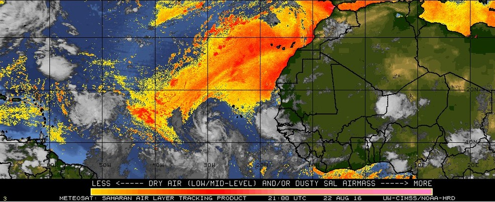
major mojo with pushing the SAL away from it's core !!!

Image
0 likes   

tolakram
Admin
Admin
Posts: 20009
Age: 62
Joined: Sun Aug 27, 2006 8:23 pm
Location: Florence, KY (name is Mark)

Re: ATL: SEVEN - Tropical Depression - Discussion

#172 Postby tolakram » Mon Aug 22, 2016 7:18 pm

Very impressive looking. Saved loop.

Image
0 likes   
M a r k
- - - - -
Join us in chat: Storm2K Chatroom Invite. Android and IOS apps also available.

The posts in this forum are NOT official forecasts and should not be used as such. Posts are NOT endorsed by any professional institution or STORM2K.org. For official information and forecasts, please refer to NHC and NWS products.

User avatar
cycloneye
Admin
Admin
Posts: 145295
Age: 68
Joined: Thu Oct 10, 2002 10:54 am
Location: San Juan, Puerto Rico

Re: ATL: SEVEN - Tropical Depression - Discussion

#173 Postby cycloneye » Mon Aug 22, 2016 7:20 pm

:uarrow: Gaston is around the corner.Looking great with superb outflow.
2 likes   
Visit the Caribbean-Central America Weather Thread where you can find at first post web cams,radars
and observations from Caribbean basin members Click Here

User avatar
p1nheadlarry
Category 2
Category 2
Posts: 672
Age: 33
Joined: Wed Jan 29, 2014 2:42 pm
Location: SR County FL

Re: ATL: SEVEN - Tropical Depression - Discussion

#174 Postby p1nheadlarry » Mon Aug 22, 2016 7:32 pm

cycloneye wrote::uarrow: Gaston is around the corner.Looking great with superb outflow.


Has a couple days before it hits higher shear to keep this going, might fight it off fairly well. I hope it becomes a harmless thing of beauty.

Image
0 likes   
--;->#GoNoles--;->.

CrazyC83
Professional-Met
Professional-Met
Posts: 34002
Joined: Tue Mar 07, 2006 11:57 pm
Location: Deep South, for the first time!

Re: ATL: SEVEN - Tropical Depression - Discussion

#175 Postby CrazyC83 » Mon Aug 22, 2016 7:36 pm

TXNT24 KNES 221830
TCSNTL

A. TROPICAL DISTURBANCE (90L)

B. 22/1800Z

C. 12.1N

D. 27.9W

E. THREE/MET-10

F. T2.5/2.5/D1.0/24HRS

G. IR/EIR/VIS

H. REMARKS...CONVECTION WRAPS 5/10 ON LOG10 SPIRAL FOR A DT OF
2.5. MET=1.5 AND PT=1.5. FT IS BASED ON DT.

I. ADDL POSITIONS

NIL


...KIM
0 likes   

User avatar
Kazmit
Category 5
Category 5
Posts: 2124
Age: 22
Joined: Mon Jul 25, 2016 8:49 am
Location: Williamsburg, VA / Bermuda

Re: ATL: SEVEN - Tropical Depression - Discussion

#176 Postby Kazmit » Mon Aug 22, 2016 7:44 pm

Nice SAT image of TD 7 uploaded to Wikipedia today.
Image
0 likes   
Igor 2010, Sandy 2012, Fay 2014, Gonzalo 2014, Joaquin 2015, Nicole 2016, Humberto 2019

I am only a tropical weather enthusiast. My predictions are not official and may or may not be backed by sound meteorological data. For official information, please refer to the NHC and NWS products.

NotoSans
Category 5
Category 5
Posts: 1380
Age: 25
Joined: Sun Sep 27, 2015 1:15 am
Location: Toronto
Contact:

Re: ATL: SEVEN - Tropical Depression - Discussion

#177 Postby NotoSans » Mon Aug 22, 2016 7:47 pm

00Z best track up to 35 kt. Maybe Gaston at 03Z?

AL, 07, 2016082300, , BEST, 0, 124N, 299W, 35, 1005, TS, 34, NEQ, 50, 30, 30, 30, 1014, 300, 40, 0, 0, L, 0, , 0, 0, SEVEN, M, 0, , 0, 0, 0, 0, genesis-num, 014,
0 likes   
Personal Forecast Disclaimer:
The posts in this forum are NOT official forecast and should not be used as such. They are just the opinion of the poster and may or may not be backed by sound meteorological data. They are NOT endorsed by any professional institution or storm2k.org. For official information, please refer to RSMC and NWS products.

psyclone
S2K Supporter
S2K Supporter
Posts: 4762
Joined: Wed Aug 24, 2005 9:04 pm
Location: palm harbor fl

Re: ATL: SEVEN - Tropical Depression - Discussion

#178 Postby psyclone » Mon Aug 22, 2016 7:50 pm

This looks like something you'd see in the west pac. looks like a whopper in the making
1 likes   

User avatar
cycloneye
Admin
Admin
Posts: 145295
Age: 68
Joined: Thu Oct 10, 2002 10:54 am
Location: San Juan, Puerto Rico

Re: ATL: SEVEN - Tropical Depression - Discussion

#179 Postby cycloneye » Mon Aug 22, 2016 7:55 pm

Gaston at 11 PM.

Location: 12.4°N 29.9°W
Maximum Winds: 35 kt Gusts: N/A
Minimum Central Pressure: 1005 mb
Environmental Pressure: 1014 mb
Radius of Circulation: 300 NM
Radius of Maximum Wind: 40 NM
Eye Diameter: N/A
1 likes   
Visit the Caribbean-Central America Weather Thread where you can find at first post web cams,radars
and observations from Caribbean basin members Click Here

User avatar
Kazmit
Category 5
Category 5
Posts: 2124
Age: 22
Joined: Mon Jul 25, 2016 8:49 am
Location: Williamsburg, VA / Bermuda

Re: ATL: SEVEN - Tropical Depression - Discussion

#180 Postby Kazmit » Mon Aug 22, 2016 8:00 pm

psyclone wrote:This looks like something you'd see in the west pac. looks like a whopper in the making

Just what I was thinking... This could be a big one.
0 likes   
Igor 2010, Sandy 2012, Fay 2014, Gonzalo 2014, Joaquin 2015, Nicole 2016, Humberto 2019

I am only a tropical weather enthusiast. My predictions are not official and may or may not be backed by sound meteorological data. For official information, please refer to the NHC and NWS products.


Return to “2016”

Who is online

Users browsing this forum: No registered users and 2 guests