ATL: MATTHEW - Post-Tropical - Discussion

Moderator: S2k Moderators

Message
Author
Vdogg
Category 2
Category 2
Posts: 621
Joined: Wed Aug 31, 2016 9:56 am

Re: ATL: MATTHEW - Hurricane - Discussion

#10441 Postby Vdogg » Fri Oct 07, 2016 5:13 pm

For those in Hampton Roads and North Carolina.

https://www.facebook.com/WxSynopsis/pos ... 3757288196

****SIGNIFICANT NORTH AND WEST SHIFT IN MATTHEW'S TRACK EXPECTED. EURO/CMC/GFS/NAM ALONG WITH OTHER MODELS, NOW SHOWING THIS SHIFT****

Matthew is a strong Category 2 hurricane aiming for GA and SC tonight. Saturday into early Sunday morning, Matthew will be tracking along the SC and NC coast, now tracking farther west along the coast and farther north, into the Outer Banks. What this shift does is increases the threat inland for rain/wind. Matthew's outter bands will now be placed over VA and NC, interacting with an approaching cold front. The combination of the cold front and Matthew's bands will increase the rain threat, now a widespread 3-6in+ threat for Central VA and NC, with isolated pockets of higher totals. Coastal areas and tidewater regions of VA and NC will receive 12in+. Widespread wind threat inland, gust in the 35-40mph range but along and east of I-95 40-60mph winds, along the coast 60-70mph+ winds. Wind and rain threat will start late friday night, peak Saturday and last into Sunday morning. NWS offices now issuing advisories/watches/warnings for this threat across the region. Please monitor forecast from your local NWS office and heed the warnings. I will have updates later so please check back in

Image
0 likes   

User avatar
pgoss11
Category 2
Category 2
Posts: 702
Joined: Tue Sep 02, 2003 3:55 pm

Re: ATL: MATTHEW - Hurricane - Discussion

#10442 Postby pgoss11 » Fri Oct 07, 2016 5:14 pm

Raebie wrote:SC and GA folks be safe...and let us know how you're doing. NC is watching closely.

I will try to keep you posted as long as I can here in Charleston. Outer rain bands and winds picking up. Worried about tornadic cells too.
6 likes   

hurricaneCW
Category 5
Category 5
Posts: 1794
Joined: Wed Mar 03, 2010 6:20 am
Location: Toms River, NJ

Re: ATL: MATTHEW - Hurricane - Discussion

#10443 Postby hurricaneCW » Fri Oct 07, 2016 5:17 pm

Models are trending back towards more trough interaction which would likely send the storm further N/W placing NC/VA at risk for significant impacts from flooding/winds/surge. It would also make it far less likely that Matthew would loop around. Instead he might head mostly ENE OTS.
4 likes   

psyclone
S2K Supporter
S2K Supporter
Posts: 4762
Joined: Wed Aug 24, 2005 9:04 pm
Location: palm harbor fl

Re: ATL: MATTHEW - Hurricane - Discussion

#10444 Postby psyclone » Fri Oct 07, 2016 5:17 pm

pgoss11 wrote:
Raebie wrote:SC and GA folks be safe...and let us know how you're doing. NC is watching closely.

I will try to keep you posted as long as I can here in Charleston. Outer rain bands and winds picking up. Worried about tornadic cells too.

you guys are definitely in the hot zone now. Hoping for the best
3 likes   

bcargile
S2K Supporter
S2K Supporter
Posts: 28
Joined: Mon Aug 22, 2011 3:34 pm
Location: North Topsail Beach, NC

Re: ATL: MATTHEW - Hurricane - Discussion

#10445 Postby bcargile » Fri Oct 07, 2016 5:20 pm

Vdogg wrote:For those in Hampton Roads and North Carolina.

https://www.facebook.com/WxSynopsis/pos ... 3757288196

****SIGNIFICANT NORTH AND WEST SHIFT IN MATTHEW'S TRACK EXPECTED. EURO/CMC/GFS/NAM ALONG WITH OTHER MODELS, NOW SHOWING THIS SHIFT****

Matthew is a strong Category 2 hurricane aiming for GA and SC tonight. Saturday into early Sunday morning, Matthew will be tracking along the SC and NC coast, now tracking farther west along the coast and farther north, into the Outer Banks. What this shift does is increases the threat inland for rain/wind. Matthew's outter bands will now be placed over VA and NC, interacting with an approaching cold front. The combination of the cold front and Matthew's bands will increase the rain threat, now a widespread 3-6in+ threat for Central VA and NC, with isolated pockets of higher totals. Coastal areas and tidewater regions of VA and NC will receive 12in+. Widespread wind threat inland, gust in the 35-40mph range but along and east of I-95 40-60mph winds, along the coast 60-70mph+ winds. Wind and rain threat will start late friday night, peak Saturday and last into Sunday morning. NWS offices now issuing advisories/watches/warnings for this threat across the region. Please monitor forecast from your local NWS office and heed the warnings. I will have updates later so please check back in

Image


I'm not understanding the statement here. Are you saying an additional shift after the 5 pm published track? Coming ashore before turning eastward?
0 likes   

User avatar
Okibeach
Tropical Depression
Tropical Depression
Posts: 87
Joined: Mon Aug 30, 2004 11:12 pm
Location: Oak Island NC

Re: ATL: MATTHEW - Hurricane - Discussion

#10446 Postby Okibeach » Fri Oct 07, 2016 5:23 pm

KBBOCA wrote:Anyone else thinking that once again (as in Floyd, or Irene, for instance) inland flooding might be the story of this storm (for the US at least)?

Here are projected rain totals in the Carolinas... and Eastern NC is already saturated.

 https://twitter.com/wxbrad/status/784493315047776256


This is a Huge concern here. We have been completely saturated for the last month. We will probably exceed the all time record for the past 40 days of precipitation. This would eclipse the flooding of Floyd if it does happen. They are doing all they can to get the message out about the potential for life threatening flooding.
1 likes   

tgenius
S2K Supporter
S2K Supporter
Posts: 1160
Joined: Mon May 15, 2006 5:31 pm
Location: Miami, FL

Re: ATL: MATTHEW - Hurricane - Discussion

#10447 Postby tgenius » Fri Oct 07, 2016 5:24 pm

jlauderdal wrote:
tgenius wrote:
jlauderdal wrote:Se florida more in the cone than we ever were a few days ago...October is prime time for florida

Which cone? Matthew when he comes back??

Yes..look at the nhc track for matthew

But don't think any models have him being anything but a depression by the time he's around us again right?
0 likes   

Vdogg
Category 2
Category 2
Posts: 621
Joined: Wed Aug 31, 2016 9:56 am

Re: ATL: MATTHEW - Hurricane - Discussion

#10448 Postby Vdogg » Fri Oct 07, 2016 5:26 pm

bcargile wrote:
Vdogg wrote:For those in Hampton Roads and North Carolina.

https://www.facebook.com/WxSynopsis/pos ... 3757288196

****SIGNIFICANT NORTH AND WEST SHIFT IN MATTHEW'S TRACK EXPECTED. EURO/CMC/GFS/NAM ALONG WITH OTHER MODELS, NOW SHOWING THIS SHIFT****

Matthew is a strong Category 2 hurricane aiming for GA and SC tonight. Saturday into early Sunday morning, Matthew will be tracking along the SC and NC coast, now tracking farther west along the coast and farther north, into the Outer Banks. What this shift does is increases the threat inland for rain/wind. Matthew's outter bands will now be placed over VA and NC, interacting with an approaching cold front. The combination of the cold front and Matthew's bands will increase the rain threat, now a widespread 3-6in+ threat for Central VA and NC, with isolated pockets of higher totals. Coastal areas and tidewater regions of VA and NC will receive 12in+. Widespread wind threat inland, gust in the 35-40mph range but along and east of I-95 40-60mph winds, along the coast 60-70mph+ winds. Wind and rain threat will start late friday night, peak Saturday and last into Sunday morning. NWS offices now issuing advisories/watches/warnings for this threat across the region. Please monitor forecast from your local NWS office and heed the warnings. I will have updates later so please check back in

Image


I'm not understanding the statement here. Are you saying an additional shift after the 5 pm published track? Coming ashore before turning eastward?


I'm not saying it, the met is saying it. Perhaps at the 11pm update but more than likely the 5am. NHC usually likes to wait for the euro to run again to verify trend. 18z gfs doesn't run in time to affect 5pm update. Also allows for a chance to check ensemble runs.
1 likes   

jlauderdal
S2K Supporter
S2K Supporter
Posts: 7182
Joined: Wed May 19, 2004 5:46 am
Location: NE Fort Lauderdale
Contact:

Re: ATL: MATTHEW - Hurricane - Discussion

#10449 Postby jlauderdal » Fri Oct 07, 2016 5:27 pm

Blown Away wrote:
jlauderdal wrote:Se florida more in the cone than we ever were a few days ago...October is prime time for florida


I'm so tired of cleaning up and no power I just won't accept emotionally Matt looping back... Crazy, obviously a shell of his current self at that time... :double:
icmc has it getting west then strengthning and comink back east
.that is way out in time..lets see where it is in 5 days
0 likes   

jlauderdal
S2K Supporter
S2K Supporter
Posts: 7182
Joined: Wed May 19, 2004 5:46 am
Location: NE Fort Lauderdale
Contact:

Re: ATL: MATTHEW - Hurricane - Discussion

#10450 Postby jlauderdal » Fri Oct 07, 2016 5:28 pm

tgenius wrote:
jlauderdal wrote:
tgenius wrote:Which cone? Matthew when he comes back??

Yes..look at the nhc track for matthew

But don't think any models have him being anything but a depression by the time he's around us again right?

Correct..big error in 5 days..could be nothing
1 likes   

Alyono
Professional-Met
Professional-Met
Posts: 6961
Joined: Fri Apr 26, 2013 3:52 pm
Location: Texas Coast

Re: ATL: MATTHEW - Hurricane - Discussion

#10451 Postby Alyono » Fri Oct 07, 2016 5:33 pm

seems like the aircraft has an allergy to flying through the northeast eyewall

oops, I see there are 2 planes
Last edited by Alyono on Fri Oct 07, 2016 5:34 pm, edited 1 time in total.
0 likes   

User avatar
NDG
S2K Supporter
S2K Supporter
Posts: 15446
Joined: Sun Jul 09, 2006 10:14 pm
Location: Orlando, FL

Re: ATL: MATTHEW - Hurricane - Discussion

#10452 Postby NDG » Fri Oct 07, 2016 5:34 pm

Storm surge is the most devastating damaging effects of a major hurricane, by Matthew not making landfall staying just a few miles offshore brought a wall of a storm surge very far north with it to areas that probably had never experienced such a storm surge before like the Daytona Beach area to St Augustine to Jacksonville. This is as bad if not worst than if it had made landfall as originally thought over east central FL.
2 likes   

Pughetime12
Tropical Low
Tropical Low
Posts: 32
Joined: Thu Oct 06, 2016 1:07 pm

Re: ATL: MATTHEW - Hurricane - Discussion

#10453 Postby Pughetime12 » Fri Oct 07, 2016 5:34 pm

Raebie wrote:SC and GA folks be safe...and let us know how you're doing. NC is watching closely.


Lots of rain, probably around 30 mph gusts in Mt. Pleasant, SC right now for me.
1 likes   

Vdogg
Category 2
Category 2
Posts: 621
Joined: Wed Aug 31, 2016 9:56 am

Re: ATL: MATTHEW - Hurricane - Discussion

#10454 Postby Vdogg » Fri Oct 07, 2016 5:37 pm

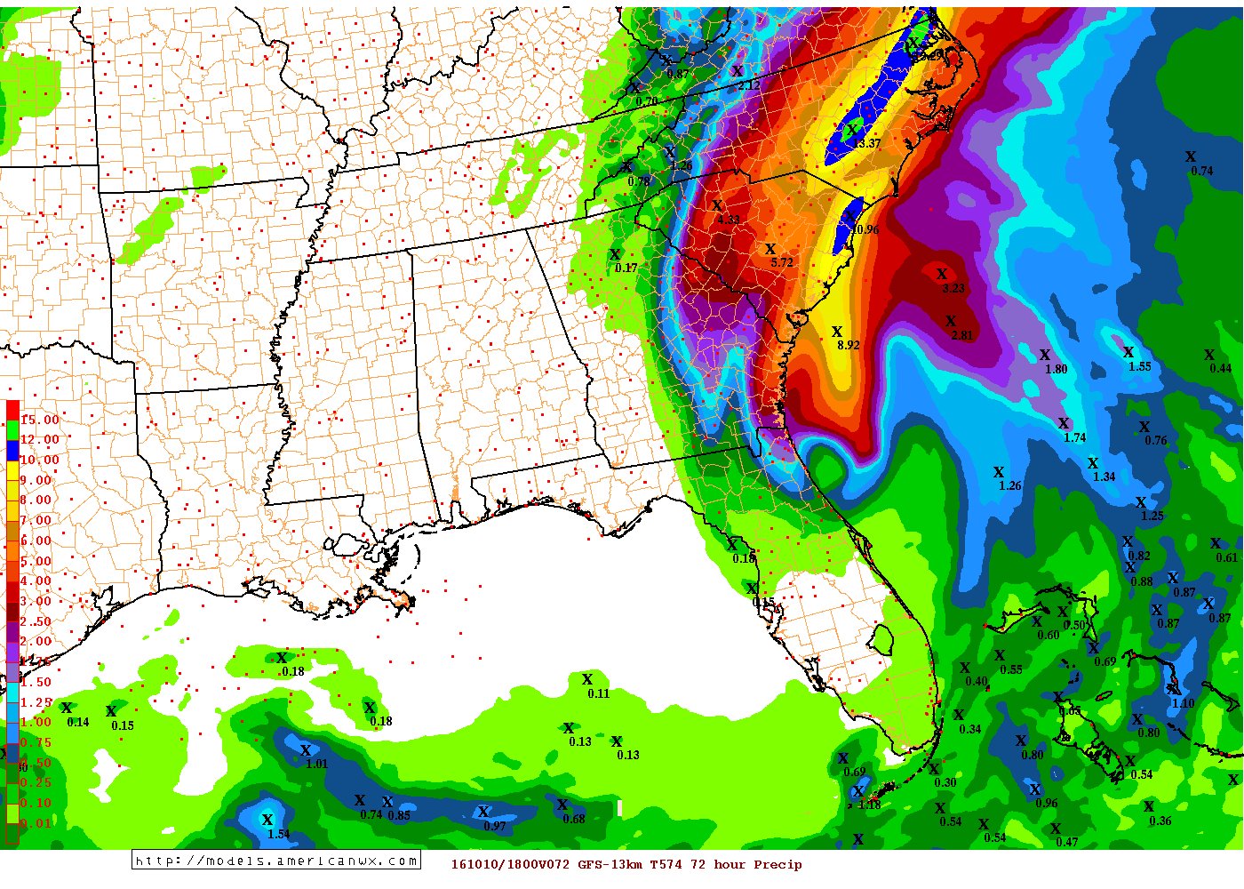
18z gfs 72 hour rainfall totals

Image
0 likes   

User avatar
NDG
S2K Supporter
S2K Supporter
Posts: 15446
Joined: Sun Jul 09, 2006 10:14 pm
Location: Orlando, FL

Re: ATL: MATTHEW - Hurricane - Discussion

#10455 Postby NDG » Fri Oct 07, 2016 5:37 pm

0 likes   

User avatar
weatherSnoop
S2K Supporter
S2K Supporter
Posts: 702
Age: 62
Joined: Wed Oct 09, 2002 10:06 pm
Location: Tampa, FL
Contact:

Re: ATL: MATTHEW - Hurricane - Discussion

#10456 Postby weatherSnoop » Fri Oct 07, 2016 5:39 pm

My sister in Ponte Vedra Beach is safe, though she has no clue what has happened to her home. Next up, my other sister: Also very safe, and hopefully having too much fun to worry about her home on Skidaway Island in Savannah. I still cannot speculate about 5-10 days down the road. Thank you to all Storm2k personnel for allowing me access to such real time information.
4 likes   

User avatar
northjaxpro
S2K Supporter
S2K Supporter
Posts: 8900
Joined: Mon Sep 27, 2010 11:21 am
Location: Jacksonville, FL

Re: ATL: MATTHEW - Hurricane - Discussion

#10457 Postby northjaxpro » Fri Oct 07, 2016 5:42 pm

psyclone wrote:
pgoss11 wrote:
Raebie wrote:SC and GA folks be safe...and let us know how you're doing. NC is watching closely.

I will try to keep you posted as long as I can here in Charleston. Outer rain bands and winds picking up. Worried about tornadic cells too.

you guys are definitely in the hot zone now. Hoping for the best


Yes praying for all across Georgia and the Carolinas.. Ple as e be safe!
2 likes   
NEVER, EVER SAY NEVER in the tropics and weather in general, and most importantly, with life itself!!

________________________________________________________________________________________

Fay 2008 Beryl 2012 Debby 2012 Colin 2016 Hermine 2016 Julia 2016 Matthew 2016 Irma 2017 Dorian 2019

User avatar
NDG
S2K Supporter
S2K Supporter
Posts: 15446
Joined: Sun Jul 09, 2006 10:14 pm
Location: Orlando, FL

Re: ATL: MATTHEW - Hurricane - Discussion

#10458 Postby NDG » Fri Oct 07, 2016 5:46 pm

A little old but just in case it was not posted.

 https://twitter.com/wjxt4/status/784468795322732545


0 likes   

jlauderdal
S2K Supporter
S2K Supporter
Posts: 7182
Joined: Wed May 19, 2004 5:46 am
Location: NE Fort Lauderdale
Contact:

Re: ATL: MATTHEW - Hurricane - Discussion

#10459 Postby jlauderdal » Fri Oct 07, 2016 5:49 pm

Alonyo.

Mr MU is on CNN talking storm surge.
0 likes   

User avatar
La Sirena
Category 1
Category 1
Posts: 307
Joined: Sun Aug 21, 2016 4:02 pm
Location: Formerly of the Keys, back home in East TN

Re: ATL: MATTHEW - Hurricane - Discussion

#10460 Postby La Sirena » Fri Oct 07, 2016 5:52 pm

jasons wrote:I was just thinking...too bad Pat Prokop retired just last year. He was one of the more level-headed TV mets I've had the pleasure of seeing over the years. Best of luck to those along the GA/SC coasts. It's gonna be a long night ahead.

We loved Pat when we lived on Tybee. Great met. Those folks who stayed on Tybee are all friends and I know they're underestimating what's going to happen.
0 likes   
The posts in this forum are NOT official forecasts and should not be used as such. They are just the opinion of the poster and may or may not be backed by sound meteorological data. They are NOT endorsed by any professional institution or STORM2K. For official information, please refer to products from the NHC and NWS.


Return to “2016”

Who is online

Users browsing this forum: No registered users and 3 guests