ATL: ANA - Post-Tropical
Moderator: S2k Moderators
-
JonathanBelles
- Professional-Met

- Posts: 11430
- Age: 35
- Joined: Sat Dec 24, 2005 9:00 pm
- Location: School: Florida State University (Tallahassee, FL) Home: St. Petersburg, Florida
- Contact:


Vortex:
Product: Air Force Vortex Message (URNT12 KNHC)
Transmitted: 7th day of the month at 23:31Z
Agency: United States Air Force
Aircraft: Lockheed WC-130J Hercules with reg. number AF97-5305
Mission Purpose: Investigate first suspect area (flight in the North Atlantic basin)
Mission Number: 2
Observation Number: 06 ( See all messages of this type for this mission. )
A. Time of Center Fix: 7th day of the month at 23:07:40Z
B. Center Fix Coordinates: 31°24'N 77°38'W (31.4N 77.6333W)
C. Minimum Height at Standard Level: 1,428m (4,685ft) at 850mb
D. Estimated (by SFMR or visually) Maximum Surface Wind: 45kts (~ 51.8mph)
E. Location of the Estimated Maximum Surface Wind: 72 nautical miles (83 statute miles) to the WNW (297°) of center fix
F. Maximum Flight Level Wind Inbound: From 31° at 45kts (From the NNE at ~ 51.8mph)
G. Location of Maximum Flight Level Wind Inbound: 80 nautical miles (92 statute miles) to the WNW (297°) of center fix
H. Minimum Sea Level Pressure: 1005mb (29.68 inHg)
I. Maximum Flight Level Temp & Pressure Altitude Outside Eye: 14°C (57°F) at a pressure alt. of 1,504m (4,934ft)
J. Maximum Flight Level Temp & Pressure Altitude Inside Eye: 15°C (59°F) at a pressure alt. of 1,505m (4,938ft)
K. Dewpoint Temp & Sea Surface Temp (collected at same location as temp inside eye): Not Available
L. Eye Character: Not Available
M. Eye Shape: Not Available
N. Fix Determined By: Penetration, Radar, Wind, Pressure and Temperature
N. Fix Level: 850mb
O. Navigational Fix Accuracy: 0.02 nautical miles
O. Meteorological Accuracy: 3 nautical miles
Remarks Section:
Maximum Flight Level Wind: 45kts (~ 51.8mph) which was observed 80 nautical miles (92 statute miles) to the WNW (297°) from the flight level center at 22:41:30Z
Maximum Flight Level Temp: 15°C (59°F) which was observed 6 nautical miles to the W (272°) from the flight level center
Dropsonde Surface Wind at Center: From 240° at 5kts (From the WSW at 6mph)
0 likes
Re: ATL: INVEST 90L
Atlantic Tropical Weather Outlook
000
ABNT20 KNHC 072345
TWOAT
SPECIAL TROPICAL WEATHER OUTLOOK
NWS NATIONAL HURRICANE CENTER MIAMI FL
745 PM EDT THU MAY 7 2015
For the North Atlantic...Caribbean Sea and the Gulf of Mexico:
Observations from an Air Force Reserve Hurricane Hunter aircraft
indicate that the area of low pressure located about 180 miles
south-southeast of the South Carolina-North Carolina border
continues to produce 40-45 mph winds mainly to the north and west
of the center. Satellite images show some increase in the
associated thunderstorm activity and if this trend continues, the
system would become a subtropical cyclone later tonight. The
low is expected to drift toward the north or north-northwest over
the next couple of days, and interests along the southeastern coast
of the United States should continue to monitor the progress of this
system. Regardless of development, heavy rain is expected over
portions of the coastal southeastern United States for the next few
days. For additional information, see products from your local
National Weather Service forecast office and High Seas Forecasts
issued by the National Weather Service. The next Special Tropical
Weather Outlook on this system is scheduled for 2 AM EDT on Friday.
* Formation chance through 48 hours...high...90 percent
* Formation chance through 5 days...high...90 percent
&&
High Seas Forecasts issued by the National Weather Service are
available under AWIPS header NFDHSFAT1, WMO header FZNT01 KWBC, and
on the Web at http://www.opc.ncep.noaa.gov/shtml/NFDHSFAT1.shtml
$$
Forecaster Pasch
0 likes

Re: ATL: INVEST 90L
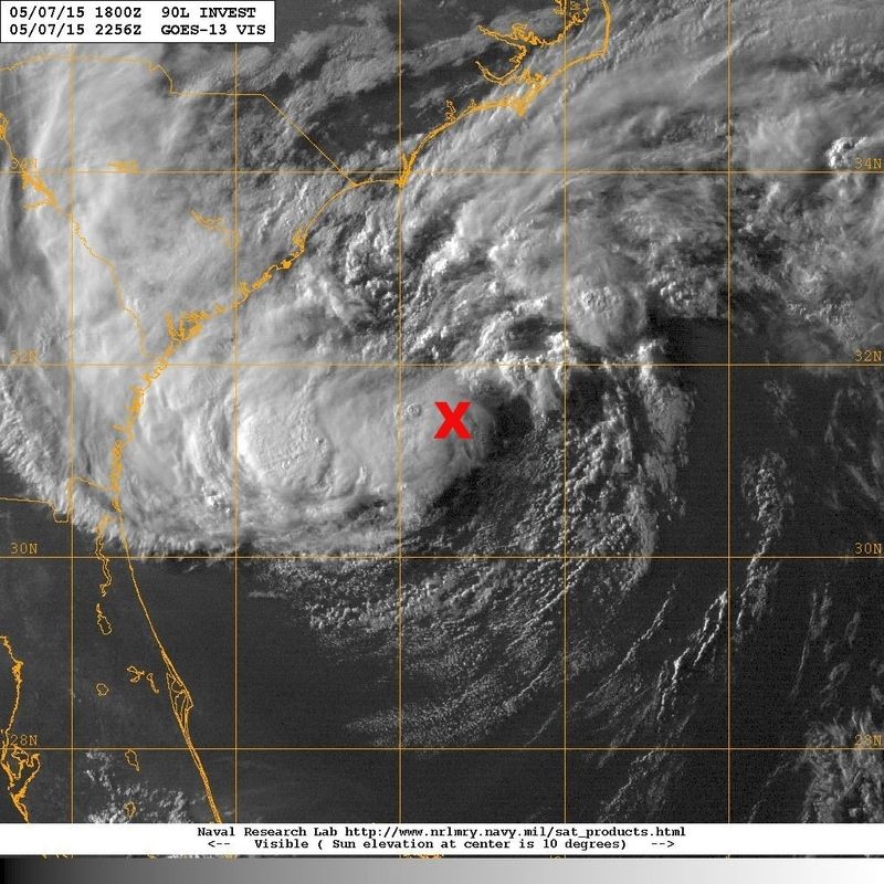
Looks like some dry air wrapping around from the south, and the convection over the center is collapsing. Ironic that the "if this trend continues" line comes as the trend stops.
0 likes
The above post is not official and should not be used as such. It is the opinion of the poster and may or may not be backed by sound meteorological data. It is not endorsed by any professional institution or storm2k.org. For official information, please refer to the NHC and NWS products.
-
wxman57

- Moderator-Pro Met

- Posts: 23177
- Age: 68
- Joined: Sat Jun 21, 2003 8:06 pm
- Location: Houston, TX (southwest)
Re: ATL: INVEST 90L
Keep in mind that the SFMR surface winds are 10-second winds, not 1-minute. Looks like a 40kt (45mph) subtropical storm, to me. I expect an upgrade in a couple of hours. No change in the threat level to the Carolinas (rain).
0 likes
-
wxman57
- Moderator-Pro Met
- Posts: 23177
- Age: 68
- Joined: Sat Jun 21, 2003 8:06 pm
- Location: Houston, TX (southwest)
Re: ATL: INVEST 90L
Here's a plot of the latest recon. Winds aren't as strong as this afternoon:

0 likes
-
TheAustinMan

- Category 5

- Posts: 1060
- Joined: Mon Jul 08, 2013 4:26 pm
- Location: Central TX / United States
Re:
JonathanBelles wrote:Anyone have decent scatterometry (ASCAT or Rapidscat) KML imagery?
I do not know of any .kml sources for scatterometry, but the Naval Research Laboratory-Monterrey does have scatterometer overlaid on satellite images available. (Located here for Invest 90L in particular for both ASCAT and Rapidscat, it appears)
0 likes
Treat my opinions with a grain of salt. For official information see your local weather service.
“It's tough to make predictions, especially about the future.”
“It's tough to make predictions, especially about the future.”
-
tolakram
- Admin

- Posts: 20188
- Age: 62
- Joined: Sun Aug 27, 2006 8:23 pm
- Location: Florence, KY (name is Mark)
Re: ATL: INVEST 90L
0 likes
M a r k
- - - - -
Join us in chat: Storm2K Chatroom Invite. Android and IOS apps also available.
The posts in this forum are NOT official forecasts and should not be used as such. Posts are NOT endorsed by any professional institution or STORM2K.org. For official information and forecasts, please refer to NHC and NWS products.
-
cycloneye

- Admin
- Posts: 149829
- Age: 69
- Joined: Thu Oct 10, 2002 10:54 am
- Location: San Juan, Puerto Rico
Re: ATL: INVEST 90L
Going to be upgraded to Subtropical Storm?
AL, 90, 2015050800, , BEST, 0, 314N, 776W, 40, 1004, SS, 34, NEQ, 140, 0, 80, 120, 1014, 160, 80, 50, 0, L, 0, , 0, 0, INVEST, M
AL, 90, 2015050800, , BEST, 0, 314N, 776W, 40, 1004, SS, 34, NEQ, 140, 0, 80, 120, 1014, 160, 80, 50, 0, L, 0, , 0, 0, INVEST, M
0 likes
Visit the Caribbean-Central America Weather Thread where you can find at first post web cams,radars
and observations from Caribbean basin members Click Here
and observations from Caribbean basin members Click Here

Re: ATL: INVEST 90L
crimi481 wrote:Looks like its drifting S.W.?
Maybe a slight jog to the west to NW, but overall not moving much. The convection rotating around is giving false the appearance of a SW movement, IMO.
0 likes
-
JonathanBelles
- Professional-Met
- Posts: 11430
- Age: 35
- Joined: Sat Dec 24, 2005 9:00 pm
- Location: School: Florida State University (Tallahassee, FL) Home: St. Petersburg, Florida
- Contact:
Latest Vortex:
Product: Air Force Vortex Message (URNT12 KNHC)
Transmitted: 8th day of the month at 1:44Z
Agency: United States Air Force
Aircraft: Lockheed WC-130J Hercules with reg. number AF97-5305
Mission Purpose: Investigate first suspect area (flight in the North Atlantic basin)
Mission Number: 2
Observation Number: 10
A. Time of Center Fix: 8th day of the month at 1:19:20Z
B. Center Fix Coordinates: 31°27'N 77°37'W (31.45N 77.6167W)
C. Minimum Height at Standard Level: 1,435m (4,708ft) at 850mb
D. Estimated (by SFMR or visually) Maximum Surface Wind: 39kts (~ 44.9mph)
E. Location of the Estimated Maximum Surface Wind: 84 nautical miles (97 statute miles) to the NE (41°) of center fix
F. Maximum Flight Level Wind Inbound: From 108° at 38kts (From the ESE at ~ 43.7mph)
G. Location of Maximum Flight Level Wind Inbound: 114 nautical miles (131 statute miles) to the NE (40°) of center fix
H. Minimum Sea Level Pressure: 1004mb (29.65 inHg)
I. Maximum Flight Level Temp & Pressure Altitude Outside Eye: 14°C (57°F) at a pressure alt. of 1,505m (4,938ft)
J. Maximum Flight Level Temp & Pressure Altitude Inside Eye: 15°C (59°F) at a pressure alt. of 1,504m (4,934ft)
K. Dewpoint Temp & Sea Surface Temp (collected at same location as temp inside eye): Not Available
L. Eye Character: Not Available
M. Eye Shape: Not Available
N. Fix Determined By: Penetration, Radar, Wind, Pressure and Temperature
N. Fix Level: 850mb
O. Navigational Fix Accuracy: 0.02 nautical miles
O. Meteorological Accuracy: 2 nautical miles
Remarks Section:
Maximum Flight Level Wind: 45kts (~ 51.8mph) which was observed 80 nautical miles (92 statute miles) to the WNW (295°) from the flight level center at 22:41:30Z
Maximum Flight Level Temp: 15°C (59°F) which was observed 60 nautical miles (69 statute miles) to the NE (36°) from the flight level center
Dropsonde Surface Wind at Center: From 165° at 9kts (From the SSE at 10mph)
0 likes
Re:
CrazyC83 wrote:Never seen them do a pre-advisory declaration...that is new.
It makes sense. Being open about it on social media when the advisory package is being written makes more sense. It allows broadcasters to be ready for the 11pm EDT news instead of having the news break at 10:55 or whenever the advisory comes out.
0 likes
Who is online
Users browsing this forum: No registered users and 13 guests