HURRICANE JIMENA DISCUSSION NUMBER 12
NWS NATIONAL HURRICANE CENTER MIAMI FL EP132015
800 AM PDT SAT AUG 29 2015
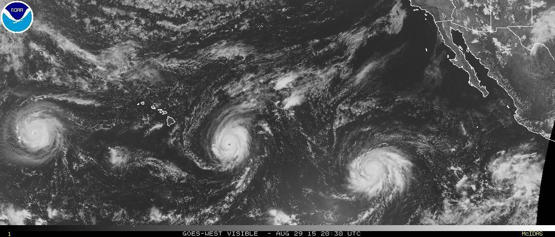
Convective cloud tops in the central dense overcast have warmed
since the last advisory, but the 10-15 n mi wide eye remains
distinct. An 0913 UTC GCOM overpass clearly indicated that the
formation of a secondary outer eyewall was almost complete, which
could be a harbinger that Jimena will soon go through an eyewall
replacement. Dvorak Current Intensity estimates at 1200 UTC were
6.0/115 kt from TAFB, 6.5/127 kt from SAB, and 6.8/135 kt from the
CIMSS ADT, and the initial intensity is held at 130 kt.
This advisory continues to show the possibility of Jimena reaching
category 5 intensity during the next 24 hours since the environment
remains conducive for strengthening. However, if Jimena does go
through an eyewall replacement soon, then fluctuations in intensity
are likely to occur, and the hurricane could actually weaken a bit
in the short term. The intensity forecast is somewhat challenging
after 24 hours. Vertical shear is expected to remain low, and sea
surface temperatures remain above 26C through the forecast period,
but the hurricane models show a general decay to a category 1 or 2
cyclone by day 5. On the other hand, the global models,
particularly the GFS and ECMWF, seem to take more advantage of the
favorable environment and retain central pressures that would
support a category 3 or 4 hurricane through day 5. Therefore, the
NHC intensity forecast shows a much slower decay than indicated by
the hurricane models, keeping Jimena as a major hurricane through
day 4.
Jimena's eye has been wobbling around, but the longer-term motion
estimate is 275/7 kt. The ridge to the north of the hurricane
appears to be weakening, and Jimena is expected to turn
west-northwestward later today. This trajectory should continue
through day 5, with a decrease in forward speed by days 4 and 5
when the steering currents become much weaker. The track guidance
is still in good agreement on the future track, and the updated NHC
forecast is similar to, but slightly faster than, the previous
forecast after 24 hours.
FORECAST POSITIONS AND MAX WINDS
INIT 29/1500Z 12.5N 125.6W 130 KT 150 MPH
12H 30/0000Z 13.0N 127.0W 135 KT 155 MPH
24H 30/1200Z 13.9N 129.1W 140 KT 160 MPH
36H 31/0000Z 14.7N 131.5W 135 KT 155 MPH
48H 31/1200Z 15.4N 133.9W 130 KT 150 MPH
72H 01/1200Z 16.5N 137.9W 115 KT 130 MPH
96H 02/1200Z 17.1N 140.5W 100 KT 115 MPH
120H 03/1200Z 17.6N 142.1W 90 KT 105 MPH
$$
Forecaster Berg
EPAC: JIMENA - Post-Tropical
Moderator: S2k Moderators
-
cycloneye

- Admin

- Posts: 149836
- Age: 69
- Joined: Thu Oct 10, 2002 10:54 am
- Location: San Juan, Puerto Rico
Re: EPAC: JIMENA - Hurricane
0 likes
Visit the Caribbean-Central America Weather Thread where you can find at first post web cams,radars
and observations from Caribbean basin members Click Here
and observations from Caribbean basin members Click Here
-
Yellow Evan

- Professional-Met

- Posts: 16257
- Age: 27
- Joined: Fri Jul 15, 2011 12:48 pm
- Location: Henderson, Nevada/Honolulu, HI
- Contact:

-
mrbagyo

- Category 5

- Posts: 4001
- Age: 33
- Joined: Thu Apr 12, 2012 9:18 am
- Location: 14.13N 120.98E
- Contact:
Re: EPAC: JIMENA - Hurricane


0 likes
The posts in this forum are NOT official forecast and should not be used as such. They are just the opinion of the poster and may or may not be backed by sound meteorological data. They are NOT endorsed by any professional institution or storm2k.org. For official information, please refer to RSMC, NHC and NWS products.
-
Yellow Evan
- Professional-Met
- Posts: 16257
- Age: 27
- Joined: Fri Jul 15, 2011 12:48 pm
- Location: Henderson, Nevada/Honolulu, HI
- Contact:
Re:
Alyono wrote:long range MU has a California landfall, moving at what may be more than 50 kts to the northeast
As an ET I think.
0 likes
-
wxmann_91

- Category 5
- Posts: 8007
- Age: 34
- Joined: Fri Jul 15, 2005 2:49 pm
- Location: Southern California
- Contact:
Re:
Alyono wrote:long range MU has a California landfall, moving at what may be more than 50 kts to the northeast
Long range GFS has also been hinting at a West Coast impact on and off.
0 likes
-
Extratropical94

- Professional-Met
- Posts: 3545
- Age: 31
- Joined: Wed Oct 20, 2010 6:36 am
- Location: Hamburg, Germany
- Contact:
Down to 120 knots.
EP, 13, 2015082918, , BEST, 0, 126N, 1259W, 120, 945, HU
TXPZ21 KNES 291824
TCSENP
A. 13E (JIMENA)
B. 29/1800Z
C. 12.7N
D. 125.9W
E. ONE/GOES-W
F. T6.0/6.5/D1.5/24HRS
G. IR/EIR/VIS
H. REMARKS...SYSTEM EMBEDDED IN LIGHT GRAY FOR AN EYE NUMBER OF 5.0.
A WARM MEDIUM GRAY EYE WITH A BLACK RING YIELDS AN EYE ADJUSTMENT OF
+1.0 FOR A DT OF 6.0. MET IS 5.5 BASED ON DEVELOPMENT COMPARED TO 24
HOURS AGO. PT IS 5.5. FT IS BASED ON DT.
I. ADDL POSITIONS
NIL
...LIDDICK
0 likes
54° 11' 59'' N, 9° 9' 20'' E
Boomer Sooner!
Go Broncos! Go Cards!
Clinching counties, one at a time: https://mob-rule.com/user-gifs/USA/xtrp94.gif
- Daniel
Boomer Sooner!
Go Broncos! Go Cards!
Clinching counties, one at a time: https://mob-rule.com/user-gifs/USA/xtrp94.gif
- Daniel
-
Yellow Evan
- Professional-Met
- Posts: 16257
- Age: 27
- Joined: Fri Jul 15, 2011 12:48 pm
- Location: Henderson, Nevada/Honolulu, HI
- Contact:
Re: EPAC: JIMENA - Hurricane
Code: Select all
                    * EAST PACIFIC SHIPS INTENSITY FORECAST          *
                    * IR SAT DATA AVAILABLE,       OHC AVAILABLE     *
                    *  JIMENA      EP132015  08/29/15  18 UTC        *

TIME (HR)          0     6    12    18    24    36    48    60    72    84    96   108   120
V (KT) NO LAND   120   118   117   116   116   113   109   107   104    96    93    86    84
V (KT) LAND      120   118   117   116   116   113   109   107   104    96    93    86    84
V (KT) LGE mod   120   118   117   117   116   114   109   101    95    86    78    71    65
Storm Type      TROP  TROP  TROP  TROP  TROP  TROP  TROP  TROP  TROP  TROP  TROP  TROP  TROP

SHEAR (KT)         6     9    14    14    10     9     6     3     3     1     7     3     3
SHEAR ADJ (KT)    -2    -3    -4    -2     0     3     4    10    11     7     4     6     6
SHEAR DIR        349   356   356     1     1     4   357    37   324   262   314   262   307
SST (C)         29.3  29.3  29.3  29.2  29.0  28.6  28.3  27.9  27.6  27.4  27.2  27.2  27.1
POT. INT. (KT)   158   158   158   158   155   152   148   143   139   136   133   133   132
200 MB T (C)   -51.0 -50.6 -50.9 -50.8 -50.7 -50.3 -50.3 -50.0 -50.6 -50.5 -50.8 -50.9 -51.1
TH_E DEV (C)       9    10    10    10     9     9     9     9     8     8     8     8     8
700-500 MB RH     63    61    57    57    57    57    58    62    66    66    65    65    65
MODEL VTX (KT)    31    30    33    33    35    35    36    39    40    39    41    40    42
850 MB ENV VOR    53    60    58    51    55    76    67    76    79    86    92   103   109
200 MB DIV       132    96    52    62    75    50    51    25    47    29    45    26    25
700-850 TADV      -3    -6    -9    -6    -6    -5     0    10    10     7     5     3     4
LAND (KM)       1971  2014  2062  2121  2168  2310  2149  1925  1749  1607  1498  1408  1331
LAT (DEG N)     12.6  13.0  13.4  13.9  14.3  15.0  15.7  16.3  16.7  17.0  17.2  17.5  17.7
LONG(DEG W)    125.9 126.9 127.8 129.0 130.1 132.6 134.9 136.9 138.5 139.8 140.8 141.6 142.3
STM SPEED (KT)     9    10    11    12    12    13    11     9     7     5     5     4     3
HEAT CONTENT      39    41    45    54    33    23    16    47    26    18     9     8     9

  FORECAST TRACK FROM OFCI      INITIAL HEADING/SPEED (DEG/KT):285/  8      CX,CY:  -7/  2
  T-12 MAX WIND: 125            PRESSURE OF STEERING LEVEL (MB):  566  (MEAN=581)
  GOES IR BRIGHTNESS TEMP. STD DEV.  50-200 KM RAD:   8.4 (MEAN=14.5)
  % GOES IR PIXELS WITH T < -20 C    50-200 KM RAD:  99.0 (MEAN=65.0)

                        INDIVIDUAL CONTRIBUTIONS TO INTENSITY CHANGE
                         6   12   18   24   36   48   60   72   84   96  108  120
                        ----------------------------------------------------------
  SAMPLE MEAN CHANGE     0.   0.   0.   1.   1.   1.   0.   0.  -1.  -1.  -2.  -2.
  SST POTENTIAL         -1.  -2.  -3.  -5. -11. -19. -27. -34. -41. -47. -51. -53.
  VERTICAL SHEAR MAG    -1.  -3.  -5.  -6.  -5.  -2.   2.   5.   7.   8.   9.   9.
  VERTICAL SHEAR ADJ     0.   1.   1.   1.   1.   0.  -1.  -1.  -2.  -2.  -3.  -4.
  VERTICAL SHEAR DIR     0.   0.   0.   0.   0.   1.   1.   1.   0.  -1.  -2.  -3.
  PERSISTENCE           -2.  -2.  -3.  -2.  -2.  -1.  -1.   0.   0.   0.   0.   0.
  200/250 MB TEMP.       0.  -1.  -2.  -3.  -5.  -8. -10. -12. -13. -14. -15. -15.
  THETA_E EXCESS         0.   0.   0.   1.   1.   1.   1.   1.   1.   1.   0.   0.
  700-500 MB RH          0.   0.   0.   0.   0.   0.   1.   1.   1.   2.   2.   2.
  MODEL VTX TENDENCY     0.   1.   2.   4.   6.   8.  11.  13.  11.  15.  14.  15.
  850 MB ENV VORTICITY   0.   0.   0.   0.   1.   1.   2.   3.   4.   5.   6.   7.
  200 MB DIVERGENCE      1.   1.   1.   2.   2.   2.   2.   1.   1.   0.  -1.  -1.
  850-700 T ADVEC        0.   0.   0.   0.   1.   1.   0.   0.   0.   0.   0.   1.
  ZONAL STORM MOTION     0.   0.   0.   0.   0.   0.   0.   0.   0.   0.   0.   0.
  STEERING LEVEL PRES    0.   0.   0.   0.   0.   0.   0.   0.   0.   0.   0.   0.
  DAYS FROM CLIM. PEAK   0.   0.   0.   0.   0.   0.   0.   1.   1.   2.   2.   2.
  GOES PREDICTORS        1.   1.   1.   1.   2.   3.   4.   4.   5.   5.   6.   5.
  OCEAN HEAT CONTENT     0.   1.   1.   2.   2.   2.   2.   2.   2.   1.   1.   1.
                        ----------------------------------------------------------
  TOTAL CHANGE          -2.  -3.  -4.  -4.  -7. -11. -13. -16. -24. -27. -34. -36.

   ** 2013 E. Pacific RI INDEX EP132015 JIMENA     08/29/15  18 UTC **
           ( 30 KT OR MORE MAX WIND INCREASE IN NEXT 24 HR)

 12 HR PERSISTENCE (KT):  -5.0 Range:-22.0 to  38.5 Scaled/Wgted Val:  0.3/  0.6
 850-200 MB SHEAR (KT) :  10.7 Range: 18.7 to   1.4 Scaled/Wgted Val:  0.5/  0.7
 POT = MPI-VMAX (KT)   :  37.4 Range: 40.3 to 141.7 Scaled/Wgted Val:  0.0/  0.0
 STD DEV OF IR BR TEMP :   8.4 Range: 38.9 to   2.4 Scaled/Wgted Val:  0.8/  0.9
 Heat content (KJ/cm2) :  42.4 Range:  3.6 to  75.9 Scaled/Wgted Val:  0.5/  0.5
 D200 (10**7s-1)       :  83.4 Range:-11.0 to 135.3 Scaled/Wgted Val:  0.6/  0.5
 % area w/pixels <-30 C:  98.0 Range: 41.4 to 100.0 Scaled/Wgted Val:  1.0/  0.5
 850-700 MB REL HUM (%):  67.6 Range: 57.6 to  96.8 Scaled/Wgted Val:  0.3/  0.0

 Prob of RI for 25 kt RI threshold=    21% is   1.6 times the sample mean(13.1%)
 Prob of RI for 30 kt RI threshold=     3% is   0.3 times the sample mean( 8.7%)
 Prob of RI for 35 kt RI threshold=     2% is   0.3 times the sample mean( 6.0%)
 Prob of RI for 40 kt RI threshold=     1% is   0.3 times the sample mean( 4.3%)

   ##         ANNULAR HURRICANE INDEX (AHI) EP132015 JIMENA     08/29/15  18 UTC         ##
   ## STORM NOT ANNULAR, SCREENING STEP FAILED, NPASS=5 NFAIL=2                          ##
   ## AHI=  0   (AHI OF 100 IS BEST FIT TO ANN. STRUC., 1 IS MARGINAL, 0 IS NOT ANNULAR) ##
0 likes
-
Yellow Evan
- Professional-Met
- Posts: 16257
- Age: 27
- Joined: Fri Jul 15, 2011 12:48 pm
- Location: Henderson, Nevada/Honolulu, HI
- Contact:
-
Kingarabian

- S2K Supporter

- Posts: 16383
- Joined: Sat Aug 08, 2009 3:06 am
- Location: Honolulu, Hawaii
Re:
Yellow Evan wrote:12z ECMWF brings this north of Hawaii. So much for an easy re-curve.

0 likes
RIP Kobe Bryant
-
Yellow Evan
- Professional-Met
- Posts: 16257
- Age: 27
- Joined: Fri Jul 15, 2011 12:48 pm
- Location: Henderson, Nevada/Honolulu, HI
- Contact:

-
Kingarabian
- S2K Supporter
- Posts: 16383
- Joined: Sat Aug 08, 2009 3:06 am
- Location: Honolulu, Hawaii
-
galaxy401

- Category 5
- Posts: 2446
- Age: 30
- Joined: Sat Aug 25, 2012 9:04 pm
- Location: Casa Grande, Arizona
Re:
Kingarabian wrote::uarrow:
Looks like it's ready to proceed to Category 5.
Not really since it looks like it is undergoing an EWRC.
0 likes
Got my eyes on moving right into Hurricane Alley: Florida.
-
Kingarabian
- S2K Supporter
- Posts: 16383
- Joined: Sat Aug 08, 2009 3:06 am
- Location: Honolulu, Hawaii
Re: Re:
galaxy401 wrote:Kingarabian wrote::uarrow:
Looks like it's ready to proceed to Category 5.
Not really since it looks like it is undergoing an EWRC.
Another one? I thought it just finished one.
0 likes
RIP Kobe Bryant
-
cycloneye
- Admin
- Posts: 149836
- Age: 69
- Joined: Thu Oct 10, 2002 10:54 am
- Location: San Juan, Puerto Rico
Re: EPAC: JIMENA - Hurricane
Wow.

0 likes
Visit the Caribbean-Central America Weather Thread where you can find at first post web cams,radars
and observations from Caribbean basin members Click Here
and observations from Caribbean basin members Click Here
-
Yellow Evan
- Professional-Met
- Posts: 16257
- Age: 27
- Joined: Fri Jul 15, 2011 12:48 pm
- Location: Henderson, Nevada/Honolulu, HI
- Contact:
Re:
Kingarabian wrote::uarrow:
Looks like it's ready to proceed to Category 5.
It's in the midst of an ERC.
0 likes
-
cycloneye
- Admin
- Posts: 149836
- Age: 69
- Joined: Thu Oct 10, 2002 10:54 am
- Location: San Juan, Puerto Rico
Re: EPAC: JIMENA - Hurricane
HURRICANE JIMENA DISCUSSION NUMBER 13
NWS NATIONAL HURRICANE CENTER MIAMI FL EP132015
200 PM PDT SAT AUG 29 2015
Recent microwave imagery continued to show Jimena's eyewall nearly
enclosed by a larger outer ring of convection, signaling that
concentric eyewalls may be developing. A moat region is also
evident in the latest visible images. Cloud tops have gradually
warmed since this morning, and Jimena appears to have weakened a
little. The initial intensity is set at 120 kt based on a blend of
CI numbers of 6.0/115 from TAFB, 6.5/127 kt from SAB, and 6.3/122
kt from the CIMSS ADT.
Jimena may be in the early stages of an eyewall replacement, which
makes the short-term intensity forecast a little tricky. The
overall environment remains conducive for strengthening, so if an
eyewall replacement occurs, the hurricane has an opportunity to
re-intensify during the next day or so. The bottom line is that
fluctuations in intensity are likely during the next 24-48 hours,
and Jimena is expected to remain a major hurricane during that
time. After 48 hours, gradual weakening is indicated in the
forecast, with the most likely reason being lower oceanic heat
content. The hurricane models continue to show a much faster
weakening rate than the global models, and as a compromise, the
updated NHC intensity forecast lies near the upper end of the
typically skillful models. This solution is closest to the SHIPS
model.
Jimena has turned west-northwestward with an initial motion of
285/8 kt. The subtropical ridge north of the hurricane is
weakening, and Jimena is expected to continue moving toward the
west-northwest through day 5. However, the cyclone should slow down
considerably by days 4 and 5 due to weakening steering currents.
The track guidance has continued to trend faster, and the updated
NHC track forecast is again a little bit ahead of the previous
forecast.
FORECAST POSITIONS AND MAX WINDS
INIT 29/2100Z 12.8N 126.4W 120 KT 140 MPH
12H 30/0600Z 13.4N 128.1W 125 KT 145 MPH
24H 30/1800Z 14.2N 130.4W 120 KT 140 MPH
36H 31/0600Z 15.0N 133.0W 115 KT 130 MPH
48H 31/1800Z 15.6N 135.4W 110 KT 125 MPH
72H 01/1800Z 16.6N 139.1W 105 KT 120 MPH
96H 02/1800Z 17.4N 141.3W 95 KT 110 MPH
120H 03/1800Z 18.0N 142.7W 85 KT 100 MPH
$$
Forecaster Berg
0 likes
Visit the Caribbean-Central America Weather Thread where you can find at first post web cams,radars
and observations from Caribbean basin members Click Here
and observations from Caribbean basin members Click Here

-
Kingarabian
- S2K Supporter
- Posts: 16383
- Joined: Sat Aug 08, 2009 3:06 am
- Location: Honolulu, Hawaii
Who is online
Users browsing this forum: No registered users and 51 guests