Consensus models keep it about 120 miles west of Kauai now. May not even get TS winds on that track as this will not be large
Of course, they may be too far west...
WPAC: KILO - Post-Tropical
Moderator: S2k Moderators
-
Yellow Evan

- Professional-Met

- Posts: 16257
- Age: 27
- Joined: Fri Jul 15, 2011 12:48 pm
- Location: Henderson, Nevada/Honolulu, HI
- Contact:
----- Current Analysis -----
Date : 21 AUG 2015 Time : 003000 UTC
Lat : 11:23:59 N Lon : 150:55:09 W
CI# /Pressure/ Vmax
2.4 /1007.8mb/ 34.0kt
Final T# Adj T# Raw T#
2.4 2.6 3.3
Center Temp : -72.6C Cloud Region Temp : -70.6C
Scene Type : UNIFORM CDO CLOUD REGION
ADT rising as conection is pulsating
Date : 21 AUG 2015 Time : 003000 UTC
Lat : 11:23:59 N Lon : 150:55:09 W
CI# /Pressure/ Vmax
2.4 /1007.8mb/ 34.0kt
Final T# Adj T# Raw T#
2.4 2.6 3.3
Center Temp : -72.6C Cloud Region Temp : -70.6C
Scene Type : UNIFORM CDO CLOUD REGION
ADT rising as conection is pulsating
0 likes
-
Kingarabian

- S2K Supporter

- Posts: 16383
- Joined: Sat Aug 08, 2009 3:06 am
- Location: Honolulu, Hawaii
Re:
Alyono wrote:Consensus models keep it about 120 miles west of Kauai now. May not even get TS winds on that track as this will not be large
Of course, they may be too far west...
1 degree is = to about 69 miles. So with the CPHC being off by about 2 degrees, that means the consensus models could be about 136 miles off. Unless of course they're able to create their own centers etc but I think only global models are capable of doing that.
0 likes
RIP Kobe Bryant
-
Kingarabian
- S2K Supporter
- Posts: 16383
- Joined: Sat Aug 08, 2009 3:06 am
- Location: Honolulu, Hawaii
Re:
Alyono wrote:I wonder if CPHC is fixing the MLC. if so, this thing is decapitated
It's under 20kts of shear, currently.
0 likes
RIP Kobe Bryant
-
srainhoutx

- S2K Supporter
- Posts: 6919
- Age: 68
- Joined: Sun Jan 14, 2007 11:34 am
- Location: Haywood County, NC
- Contact:
Re: CPAC: THREE-C - Tropical Depression
Looks like the surface low is attempting to consolidate around 11.5N/151.5W. That's a bit E of the MLC.
0 likes
Carla/Alicia/Jerry(In The Eye)/Michelle/Charley/Ivan/Dennis/Katrina/Rita/Wilma/Ike/Harvey
Member: National Weather Association
Wx Infinity Forums
http://wxinfinity.com/index.php
Facebook.com/WeatherInfinity
Twitter @WeatherInfinity
Member: National Weather Association
Wx Infinity Forums
http://wxinfinity.com/index.php
Facebook.com/WeatherInfinity
Twitter @WeatherInfinity
-
Kingarabian
- S2K Supporter
- Posts: 16383
- Joined: Sat Aug 08, 2009 3:06 am
- Location: Honolulu, Hawaii

-
srainhoutx
- S2K Supporter
- Posts: 6919
- Age: 68
- Joined: Sun Jan 14, 2007 11:34 am
- Location: Haywood County, NC
- Contact:
Re: CPAC: THREE-C - Tropical Depression
Yes it has. The two 53rd C-130's were parked at Hickam when I landed from a helicopter tour of Oahu. Just chatted with my friend that will be flying the night missions. The crews are anxious to get out there and gather some data to assist with the forecasts for this TC.
0 likes
Carla/Alicia/Jerry(In The Eye)/Michelle/Charley/Ivan/Dennis/Katrina/Rita/Wilma/Ike/Harvey
Member: National Weather Association
Wx Infinity Forums
http://wxinfinity.com/index.php
Facebook.com/WeatherInfinity
Twitter @WeatherInfinity
Member: National Weather Association
Wx Infinity Forums
http://wxinfinity.com/index.php
Facebook.com/WeatherInfinity
Twitter @WeatherInfinity
-
Kingarabian
- S2K Supporter
- Posts: 16383
- Joined: Sat Aug 08, 2009 3:06 am
- Location: Honolulu, Hawaii
Re: CPAC: THREE-C - Tropical Depression
srainhoutx wrote::uarrow:
Yes it has. The two 53rd C-130's were parked at Hickam when I landed from a helicopter tour of Oahu. Just chatted with my friend that will be flying the night missions. The crews are anxious to get out there and gather some data to assist with the forecasts for this TC.
That's awesome! Nothing like seeing a C-130 Hercules from above!
Tell them the people of Hawaii appreciate everything that they're doing and we can't thank them enough.
0 likes
RIP Kobe Bryant
-
Kingarabian
- S2K Supporter
- Posts: 16383
- Joined: Sat Aug 08, 2009 3:06 am
- Location: Honolulu, Hawaii
WTPA41 PHFO 210250
TCDCP1
TROPICAL DEPRESSION THREE-C DISCUSSION NUMBER 2
NWS CENTRAL PACIFIC HURRICANE CENTER HONOLULU HI CP032015
500 PM HST THU AUG 20 2015
THE ORGANIZATION OF TROPICAL DEPRESSION THREE-C HAS NOT IMPROVED
THROUGH THE DAY AND THE CONFIDENCE IN THE CENTER POSITION REMAINS
POOR. AT AROUND 0000 UTC...AN APPARENT LOW LEVEL CLOUD SWIRL
APPEARED FROM BENEATH THE MAIN CLOUD MASS AND MOVED TOWARD THE
NORTHEAST. WHILE IT IS POSSIBLE THAT THIS IS THE LOW LEVEL CENTER
OF THE SYSTEM...LOW CLOUD LINE CURVATURE TO THE NORTHWEST OF THE
CIRRUS SHIELD AND THE CURVATURE OF THE WIND FIELD IN AN EARLIER
ASCAT PASS SUGGEST THAT A CENTER COULD BE SOUTH OF THE DEEPEST
CONVECTION. THIS WOULD BE CONSISTENT WITH THE CONTINUITY OF THE
PREVIOUSLY DERIVED MOTION. THE 0011 UTC AMSU PASS WAS NOT
CONSIDERED TO BE CONCLUSIVE IN DETERMINING THE CENTER POSITION.
DVORAK INTENSITY ESTIMATES CAME IN AT 35 KT FROM PHFO...30 KT FROM
SAB AND 25 KT FROM JTWC. THE INITIAL INTENSITY FOR THIS PACKAGE HAS
BEEN HELD AT 30 KT.
THE INITIAL MOVEMENT FOR THIS PACKAGE IS 280/14 KT. OBJECTIVE AIDS
REMAIN TIGHTLY LINED UP WITH A GENERAL WEST-NORTHWEST MOTION OVER
THE NEXT COUPLE OF DAYS AS THE SYSTEM MOVES SOUTH OF A MID-LEVEL
RIDGE BUILDING WESTWARD. A WEAKNESS IN THE RIDGE IS EXPECTED TO
DEVELOP WHICH WOULD RESULT IN A DECREASE IN FORWARD MOTION AND A
GRADUAL TURN TOWARD THE NORTH OR NORTH-NORTHEAST. THE MAIN DYNAMICAL
MODELS DIFFER ON THE LOCATION OF THE TURN WITH THE HWRF AND GFS
REMAINING ON THE EAST SIDE OF THE GUIDANCE ENVELOPE AND THE ECMWF ON
THE WEST SIDE. THE TIMING OF THE TURN WILL DEPEND ON WHEN THE
WEAKNESS IN THE MID-LEVEL RIDGE OCCURS. THE LONGER IT TAKES...THE
FARTHER WEST THE CYCLONE WILL MOVE BEFORE TURNING AND THIS ASPECT OF
THE FORECAST HAS THE MOST UNCERTAINTY. THIS FORECAST PACKAGE
HAS BEEN ADJUSTED SOUTH FROM THE PREVIOUS PACKAGE AND IS BETWEEN
THE DYNAMIC CONSENSUS AND HWRF THROUGH 36 HOURS THEN IS
EAST OF THE DYNAMICAL MODEL ENVELOPE THROUGH THE REMAINDER OF THE
FORECAST PERIOD. NOTE THAT IF THE LOW CENTER HAS INDEED SHIFTED TO
THE NORTHEAST AND DEEP CONVECTION REDEVELOPS NEAR IT...SUBSEQUENT
FORECASTS WILL HAVE TO BE ADJUSTED TO ACCOUNT FOR THIS CHANGE.
THREE-C IS MOVING OVER VERY WARM WATER...ABOVE 29C IN THE LATEST
ANALYSIS. EASTERLY SHEAR CONTINUES TO IMPACT THE SYSTEM BUT IS
EXPECTED TO STEADILY WEAKEN AT LEAST THROUGH 48 HOURS AND REMAIN
WEAK THROUGH 96 HOURS. THESE FACTORS SUGGEST THAT THE DEPRESSION
SHOULD CONTINUE TO STRENGTHEN...ASSUMING THAT THE LOW LEVEL CENTER
HAS NOT BEEN DECOUPLED FROM THE SYSTEM. THE CURRENT FORECAST
CONSERVATIVELY HOLDS THE COURSE WITH THE PREVIOUS FORECAST AND CALLS
FOR THREE-C TO BECOME A TROPICAL STORM WITHIN THE NEXT 24 HOURS AND
A HURRICANE IN ABOUT TWO DAYS. THIS IS IN LINE WITH THE INTENSITY
CONSENSUS GUIDANCE. AS WITH THE TRACK FORECAST...THE INTENSITY
FORECAST WILL NEED TO BE ADJUSTED IF THE LOW LEVEL CENTER HAS BECOME
SEPARATED FROM THE REST OF THE SYSTEM.
U.S AIR FORCE RESERVE WEATHER RECONNAISSANCE ASSETS ARE IN THE
PROCESS OF DEPLOYING TO HAWAII AND A WC-130J IS SCHEDULED TO MAKE AN
INITIAL PASS THROUGH THREE-C FRIDAY EVENING. THIS WILL PROVIDE
VALUABLE DATA TO HELP BETTER DETERMINE THE LOCATION OF THE SYSTEM
CENTER AND THE DISTRIBUTION OF THE WIND FIELD.
FORECAST POSITIONS AND MAX WINDS
INIT 21/0300Z 11.0N 151.5W 30 KT 35 MPH
12H 21/1200Z 11.5N 153.6W 35 KT 40 MPH
24H 22/0000Z 12.3N 156.4W 45 KT 50 MPH
36H 22/1200Z 13.2N 159.3W 60 KT 70 MPH
48H 23/0000Z 14.7N 162.0W 70 KT 80 MPH
72H 24/0000Z 17.3N 163.7W 80 KT 90 MPH
96H 25/0000Z 19.5N 163.0W 85 KT 100 MPH
120H 26/0000Z 21.0N 162.0W 85 KT 100 MPH
$$
FORECASTER KODAMA
0 likes
RIP Kobe Bryant
-
Kingarabian
- S2K Supporter
- Posts: 16383
- Joined: Sat Aug 08, 2009 3:06 am
- Location: Honolulu, Hawaii
Re:
Alyono wrote:that anti-cyclone is over the LLC. We need to watch and see if convection redevelops over that LLC
What affects will it have on the track if the LLC is that far east?
But anyways, it seems as if the CPHC has no idea on the location of the LLC as well.
0 likes
RIP Kobe Bryant
Re: Re:
Kingarabian wrote:Alyono wrote:that anti-cyclone is over the LLC. We need to watch and see if convection redevelops over that LLC
What affects will it have on the track if the LLC is that far east?
But anyways, it seems as if the CPHC has no idea on the location of the LLC as well.
probably means the Canadian Model is correct as it had this split setup
0 likes
-
Kingarabian
- S2K Supporter
- Posts: 16383
- Joined: Sat Aug 08, 2009 3:06 am
- Location: Honolulu, Hawaii
Re: Re:
Alyono wrote:Kingarabian wrote:Alyono wrote:that anti-cyclone is over the LLC. We need to watch and see if convection redevelops over that LLC
What affects will it have on the track if the LLC is that far east?
But anyways, it seems as if the CPHC has no idea on the location of the LLC as well.
probably means the Canadian Model is correct as it had this split setup
That would be insane. The Canadian getting something right over the GFS and Euro.
0 likes
RIP Kobe Bryant
-
Kingarabian
- S2K Supporter
- Posts: 16383
- Joined: Sat Aug 08, 2009 3:06 am
- Location: Honolulu, Hawaii
Re:
Alyono wrote:Here is one thing, given the easterly shear, it is highly unlikely that the LLC is WEST of the convection, like where CPHC is putting it.
Perhaps there is NO center yet
GFS gets going 20 minutes. Let's see what it depicts.
0 likes
RIP Kobe Bryant
-
Yellow Evan
- Professional-Met
- Posts: 16257
- Age: 27
- Joined: Fri Jul 15, 2011 12:48 pm
- Location: Henderson, Nevada/Honolulu, HI
- Contact:
-
Kingarabian
- S2K Supporter
- Posts: 16383
- Joined: Sat Aug 08, 2009 3:06 am
- Location: Honolulu, Hawaii
-
Yellow Evan
- Professional-Met
- Posts: 16257
- Age: 27
- Joined: Fri Jul 15, 2011 12:48 pm
- Location: Henderson, Nevada/Honolulu, HI
- Contact:
Re:
Kingarabian wrote:It's to East because convection is really pulsing that way,
Center looks around 12N 148W to me. Still far from the deep convection.
0 likes
-
srainhoutx
- S2K Supporter
- Posts: 6919
- Age: 68
- Joined: Sun Jan 14, 2007 11:34 am
- Location: Haywood County, NC
- Contact:
Re: CPAC: THREE-C - Tropical Depression
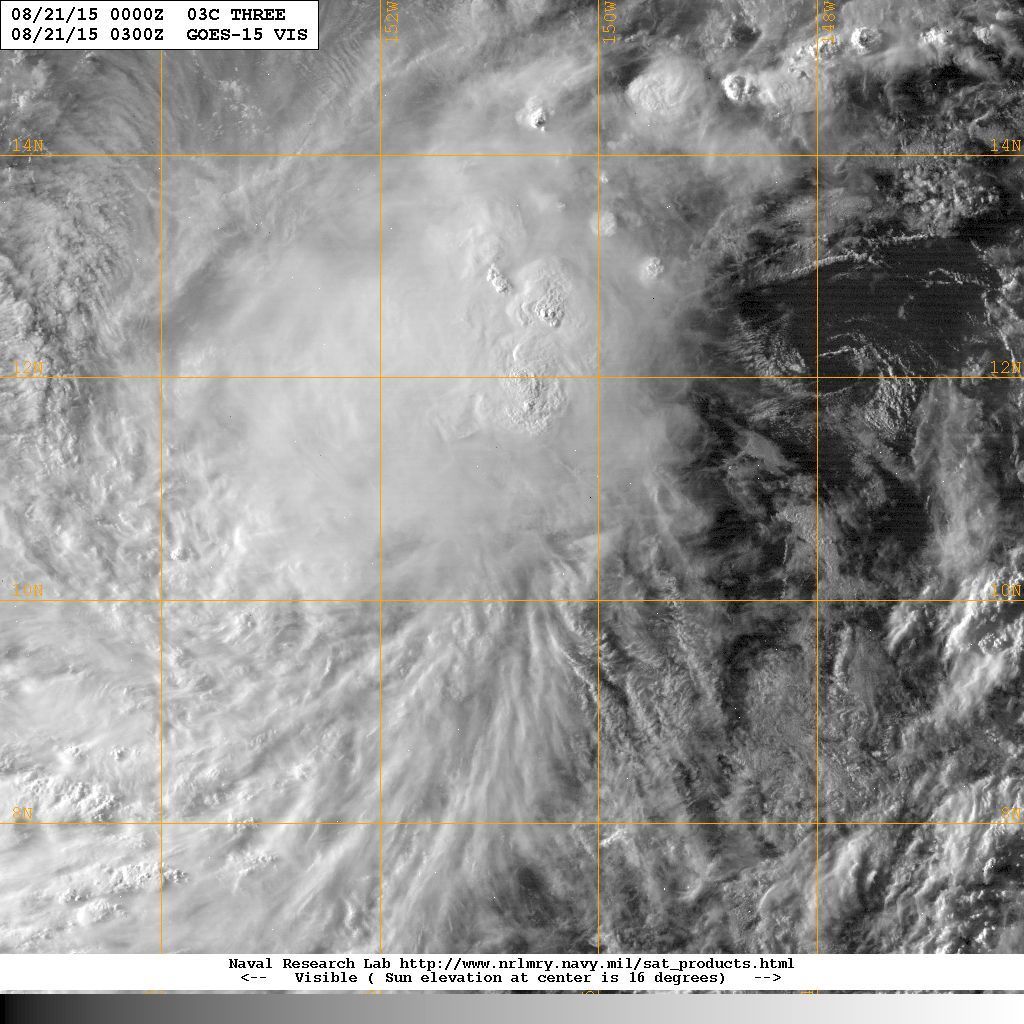
The 1km zoomed visible imagery clear shows the LLC that the CPHC mentioned off to the N and E of the main convection around 12N/145W. Looks like it may be an eddy to me, but it will certainly be interesting to see where the low level circulation center finally decides to consolidate.
0 likes
Carla/Alicia/Jerry(In The Eye)/Michelle/Charley/Ivan/Dennis/Katrina/Rita/Wilma/Ike/Harvey
Member: National Weather Association
Wx Infinity Forums
http://wxinfinity.com/index.php
Facebook.com/WeatherInfinity
Twitter @WeatherInfinity
Member: National Weather Association
Wx Infinity Forums
http://wxinfinity.com/index.php
Facebook.com/WeatherInfinity
Twitter @WeatherInfinity
Who is online
Users browsing this forum: No registered users and 63 guests