See chart
ATL: DANNY - Remnants - Discussion
Moderator: S2k Moderators
-
Gustywind

- Category 5

- Posts: 12334
- Joined: Mon Sep 03, 2007 7:29 am
- Location: Baie-Mahault, GUADELOUPE
TROPICAL CYCLONE ALERT STATEMENT
WHCA31 TAPA
HURRICANE DANNY ALERT STATEMENT
ANTIGUA AND BARBUDA METEOROLOGICAL SERVICES
11:29 PM ECT FRI, AUG 21, 2015
THIS IS FOR THE LEEWARD ISLANDS AND BRITISH VIRGIN ISLANDS
...HURRICANE DANNY HAS BEGUN TO WEAKEN...
AT 11PM ECT OR 0300Z THE CENTRE OF HURRICANE DANNY WAS LOCATED NEAR LATITUDE 14.8 NORTH, LONGITUDE 49.8 WEST OR ABOUT 793 MILES EAST SOUTH EAST OF ANTIGUA AND BARBUDA AND 990 MILES EAST SOUTH EAST OF THE BRITISH VIRGIN ISLANDS.
HURRICANE DANNY IS MOVING TOWARD THE WEST-NORTHWEST AT 10 MILES PER HOUR. AN INCREASE IN FORWARD SPEED COUPLED WITH A TURN TO THE WEST IS EXPECTED DURING THE NEXT COUPLE OF DAYS.
MAXIMUM SUSTAINED WINDS ARE NEAR 110 MPH WITH HIGHER GUSTS. ADDITIONAL WEAKENING IS EXPECTED DURING THE NEXT 48 HOURS AND DANNY SHOULD WEAKEN TO A TROPICAL STORM ON SUNDAY AS IT APPROACHES THE LEEWARD ISLANDS.
HURRICANE FORCE WINDS EXTEND UP TO 15 MILES FROM THE CENTRE, AND TROPICAL STORM FORCE WINDS EXTEND OUTWARD UP TO 60 MILES.
THE ESTIMATED MINIMUM CENTRAL PRESSURE IS 977 MB OR 28.85 INCHES.
AS ANTICIPATED, HURRICANE DANNY HAS BEGUN TO WEAKEN. HOWEVER THE LATEST FORECAST TRACK BRINGS DANNY CLOSE TO THE LEEWARD ISLANDS AND BRITISH VIRGIN ISLANDS ON MONDAY. INTEREST IN THE LEEWARD ISLANDS AND BRITISH VIRGIN ISLANDS SHOULD MONITOR THE PROGRESS OF DANNY. TROPICAL STORM WATCHES MAY BE REQUIRED FOR THE LEEWARD ISLANDS AND BRITISH VIRGIN ISLANDS ON SATURDAY.
REPEATING THE 11PM ECT POSITION, 14.8 N, 49.8 W. MOVEMENT TOWARD THE WEST-NORTHWEST NEAR 10 MPH. MAXIMUM SUSTAINED WINDS ARE NEAR 110 MPH. THE MINIMUM CENTRAL PRESSURE IS 977MB.
THE NEXT ADVISORY WILL BE AT 5AM ECT ON SATURDAY
CLICK HERE FOR MORE INFORMATION
FORECASTER ORVIN PAIGE
0 likes


Re: ATL: DANNY - Hurricane- Discussion
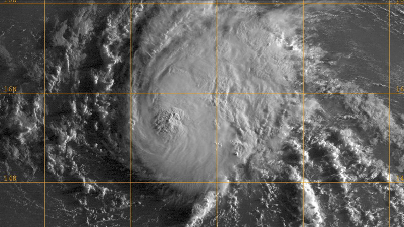
Now, I can't see visible so for all I know the LLC is south of the convection, but Danny to me appears to have a very healthy structure still.
0 likes
-
northjaxpro

- S2K Supporter

- Posts: 8900
- Joined: Mon Sep 27, 2010 11:21 am
- Location: Jacksonville, FL
Re: ATL: DANNY - Hurricane- Discussion
Nimbus wrote:Looking at the water vapor imagery the outflow is not being impinged by a "wall of shear" as many predicted.
First visible images it should be obvious there is an intact core.
End of the day there will still be a hurricane on track towards the north coast of PR.
The ridging is migrated WNW with the storm..
Yeah, I agree with you. Danny is a tenacious, tiny cyclone and he is holding his own quite nicely early this morning. The inner core is still very much intact and the southwest shear has certainly not yet disrupted the core. Danny will not weaken significantly until that inner core gets disrupted. That is expected to happen later today and into the short term. But, for the moment, Danny is putting up a good fight to maintain itself.
Last edited by northjaxpro on Sat Aug 22, 2015 5:42 am, edited 1 time in total.
0 likes
NEVER, EVER SAY NEVER in the tropics and weather in general, and most importantly, with life itself!!
________________________________________________________________________________________
Fay 2008 Beryl 2012 Debby 2012 Colin 2016 Hermine 2016 Julia 2016 Matthew 2016 Irma 2017 Dorian 2019
________________________________________________________________________________________
Fay 2008 Beryl 2012 Debby 2012 Colin 2016 Hermine 2016 Julia 2016 Matthew 2016 Irma 2017 Dorian 2019


Re: ATL: DANNY - Hurricane- Discussion
Danny as seen on microwave data has a dry slot on its SW Quadrant but it still has a decent satellite presentation this morning for encountering the TUTT 

0 likes
-
northjaxpro
- S2K Supporter
- Posts: 8900
- Joined: Mon Sep 27, 2010 11:21 am
- Location: Jacksonville, FL
Good morning NDG! As I commented a few miinutes sgo, Danny is quite a tenacious tiny fellow uh? The shear has not quite had an impact within the inner core structure and it still looks remarkably well this morning.
0 likes
NEVER, EVER SAY NEVER in the tropics and weather in general, and most importantly, with life itself!!
________________________________________________________________________________________
Fay 2008 Beryl 2012 Debby 2012 Colin 2016 Hermine 2016 Julia 2016 Matthew 2016 Irma 2017 Dorian 2019
________________________________________________________________________________________
Fay 2008 Beryl 2012 Debby 2012 Colin 2016 Hermine 2016 Julia 2016 Matthew 2016 Irma 2017 Dorian 2019
Re: ATL: DANNY - Hurricane- Discussion
Since last night it has been analyzed to be in the low 20 knot range.
There is no way windshear was 18 knots from the west when it was a Cat 3 and had such a nice satellite presentation. I wonder if because the storm is so small their program is not able to precisely have the more accurate windshear right over Danny.
In the other hand, SHIPS has been analyzing windshear over Danny much lower in the 10-12 knot range since last night, the NHC was dismissing SHIPS but to me SHIPS may not be that far off, if windshear would had been 20+ knots right over Danny's core since yesterday afternoon Danny would have had an exposed center by now.
0 likes
-
northjaxpro
- S2K Supporter
- Posts: 8900
- Joined: Mon Sep 27, 2010 11:21 am
- Location: Jacksonville, FL
Re: ATL: DANNY - Hurricane- Discussion
NDG wrote::
In the other hand, SHIPS has been analyzing windshear over Danny much lower in the 10-12 knot range since last night, the NHC was dismissing SHIPS but to me SHIPS may not be that far off, if windshear would had been 20+ knots right over Danny's core since yesterday afternoon Danny would have had an exposed center by now.
You may be onto something about this. That is a good point to make NDG.
Last edited by northjaxpro on Sat Aug 22, 2015 6:24 am, edited 2 times in total.
0 likes
NEVER, EVER SAY NEVER in the tropics and weather in general, and most importantly, with life itself!!
________________________________________________________________________________________
Fay 2008 Beryl 2012 Debby 2012 Colin 2016 Hermine 2016 Julia 2016 Matthew 2016 Irma 2017 Dorian 2019
________________________________________________________________________________________
Fay 2008 Beryl 2012 Debby 2012 Colin 2016 Hermine 2016 Julia 2016 Matthew 2016 Irma 2017 Dorian 2019
-
Gustywind
- Category 5
- Posts: 12334
- Joined: Mon Sep 03, 2007 7:29 am
- Location: Baie-Mahault, GUADELOUPE
TROPICAL CYCLONE INFORMATION STATEMENT
WHCA31 TAPA
TROPICAL CYCLONE INFORMATION STATEMENT
6:54 AM ECT SAT, AUG 22, 2015
THIS IS FOR THE LEEWARD ISLANDS AND BRITISH VIRGIN ISLANDS
HURRICANE DANNY ADVISORY NUMBER 16
NWS NATIONAL HURRICANE CENTER MIAMI FL
500 AM AST SAT AUG 22 2015
...DANNY WEAKENS A LITTLE MORE...
SUMMARY OF 500 AM AST...0900 UTC...INFORMATION
----------------------------------------------
LOCATION...15.2N 50.8W
ABOUT 740 MI...1195 KM E OF THE LEEWARD ISLANDS
MAXIMUM SUSTAINED WINDS...100 MPH...155 KM/H
PRESENT MOVEMENT...WNW OR 290 DEGREES AT 10 MPH...17 KM/H
MINIMUM CENTRAL PRESSURE...982 MB...29.00 INCHES
WATCHES AND WARNINGS
--------------------
THERE ARE NO COASTAL WATCHES OR WARNINGS IN EFFECT.
INTERESTS IN THE LEEWARD ISLANDS AND THE VIRGIN ISLANDS SHOULD
MONITOR THE PROGRESS OF DANNY. TROPICAL STORM WATCHES WILL LIKELY BE REQUIRED FOR PORTIONS OF THE LEEWARD ISLANDS AND THE VIRGIN ISLANDS LATER TODAY.
DISCUSSION AND 48-HOUR OUTLOOK
------------------------------
AT 500 AM AST (0900 UTC), THE CENTER OF HURRICANE DANNY WAS LOCATED NEAR LATITUDE 15.2 NORTH, LONGITUDE 50.8 WEST. DANNY IS MOVING TOWARD THE WEST-NORTHWEST NEAR 10 MPH (17 KM/H). A TURN TO THE WEST WITH AN INCREASE IN FORWARD SPEED IS EXPECTED LATER TODAY.
MAXIMUM SUSTAINED WINDS HAVE DECREASED TO NEAR 100 MPH (155 KM/H) WITH HIGHER GUSTS. ADDITIONAL WEAKENING IS FORECAST DURING THE NEXT 48 HOURS, AND DANNY IS EXPECTED TO BECOME A TROPICAL STORM ON SUNDAY AS IT APPROACHES THE LEEWARD ISLANDS.
HURRICANE FORCE WINDS EXTEND OUTWARD UP TO 15 MILES (30 KM) FROM THE CENTER AND TROPICAL STORM FORCE WINDS EXTEND OUTWARD UP TO 60 MILES (95 KM).
THE ESTIMATED MINIMUM CENTRAL PRESSURE IS 982 MB (29.00 INCHES).
RESIDENTS SHOULD HAVE ALL HURRICANE PREPARATION PLANS IN PLACE. IF NOT THESE SHOULD BE RUSHED TO COMPLETION AS WATCHES OR WARNING MAY BE ISSUED LATER TODAY SATURDAY.
ALTHOUGH THE DANNY IS EXPECTED TO FURTHER WEAKEN BEFORE REACHING THE SHORES OF THE LEEWARD ISLANDS BY EARLY MONDAY MORNING, RESIDENTS SHOULD CONTINUE TO PAY CLOSE ATTENTION TO DETAILS CONCERNING DANNY AS IT CONTINUES TO MOVE CLOSER TO THE LEEWARD ISLANDS.
NEXT ADVISORY WILL BE ISSUED AT ABOUT 11:45 PM
FORECASTER CECIL MATTHEW
0 likes

Re: ATL: DANNY - Hurricane- Discussion
Danny has already made the Turn to the West to 275 W, do you notice that?
0 likes
-
northjaxpro
- S2K Supporter
- Posts: 8900
- Joined: Mon Sep 27, 2010 11:21 am
- Location: Jacksonville, FL
Danny to my estimate is currently at 15.5 N 51.3 W. I can't really say for certain it is now on a 275 degree header, I would say still slightly west-northwest motion continuing for the moment.
Last edited by northjaxpro on Sat Aug 22, 2015 6:36 am, edited 2 times in total.
0 likes
NEVER, EVER SAY NEVER in the tropics and weather in general, and most importantly, with life itself!!
________________________________________________________________________________________
Fay 2008 Beryl 2012 Debby 2012 Colin 2016 Hermine 2016 Julia 2016 Matthew 2016 Irma 2017 Dorian 2019
________________________________________________________________________________________
Fay 2008 Beryl 2012 Debby 2012 Colin 2016 Hermine 2016 Julia 2016 Matthew 2016 Irma 2017 Dorian 2019
-
Weatherboy1

- Category 5
- Posts: 1190
- Age: 50
- Joined: Mon Jul 05, 2004 1:50 pm
- Location: Jupiter/Sarasota, FL
Re: ATL: DANNY - Hurricane- Discussion
NDG wrote::uarrow: I was just looking at the CIMSS site windshear map, went back to yesterday morning when it was a Cat 3, at that time they analyzed the windshear right over Danny close at around 18 knots even 20 knots at 18z when it was still a Cat 3 per the recon.
Since last night it has been analyzed to be in the low 20 knot range.
There is no way windshear was 18 knots from the west when it was a Cat 3 and had such a nice satellite presentation. I wonder if because the storm is so small their program is not able to precisely have the more accurate windshear right over Danny.
In the other hand, SHIPS has been analyzing windshear over Danny much lower in the 10-12 knot range since last night, the NHC was dismissing SHIPS but to me SHIPS may not be that far off, if windshear would had been 20+ knots right over Danny's core since yesterday afternoon Danny would have had an exposed center by now.
http://tropic.ssec.wisc.edu/real-time/w ... oom=&time=
http://tropic.ssec.wisc.edu/real-time/w ... oom=&time=
I was also looking at the wind shear maps this morning, and the highest shear values have come down to the NW of Danny. Last night, this map was showing a larger area of 30 knot shear and even a blob of 40 knots. Now, the 40 knot shear is well to the west and the 30 area is shrinking. The band of stronger shear also appears to be smaller than a couple days ago.
I'm not going to argue that Danny looks as good this morning on satellite as he did yesterday. He doesn't. But he still looks pretty good and he doesn't have the look of a massively sheared system even on the first visible images. Maybe it will be worse tomorrow, but if he maintains this appearance, and keeps missing forecast points to the north (something that would allow him to miss the islands potentially), I wouldn't t totally write him off yet.
As always, remember I am not an expert and these are just my semi-educated amateur opinions
Last edited by Weatherboy1 on Sat Aug 22, 2015 6:36 am, edited 1 time in total.
0 likes
-
CourierPR

- Category 5
- Posts: 1336
- Age: 72
- Joined: Tue Aug 31, 2004 7:53 pm
- Location: Pompano Beach, Florida
Re:
Danny to my estimate is currently at 15.5 N 51.3 W. I can't really say for certain it is now on a 275 degree header, I would say still slightly west-northwest motion continuing for the moment.[/quote]
I agree. NHC stated 290 degrees which seems about right.
I agree. NHC stated 290 degrees which seems about right.
0 likes
-
AJC3

- Admin

- Posts: 4153
- Age: 62
- Joined: Tue Aug 31, 2004 7:04 pm
- Location: Ballston Spa, New York
- Contact:
Re: ATL: DANNY - Hurricane- Discussion
NDG wrote::uarrow: I was just looking at the CIMSS site windshear map, went back to yesterday morning when it was a Cat 3, at that time they analyzed the windshear right over Danny close at around 18 knots even 20 knots at 18z when it was still a Cat 3 per the recon.
Since last night it has been analyzed to be in the low 20 knot range.
There is no way windshear was 18 knots from the west when it was a Cat 3 and had such a nice satellite presentation. I wonder if because the storm is so small their program is not able to precisely have the more accurate windshear right over Danny.
In the other hand, SHIPS has been analyzing windshear over Danny much lower in the 10-12 knot range since last night, the NHC was dismissing SHIPS but to me SHIPS may not be that far off, if windshear would had been 20+ knots right over Danny's core since yesterday afternoon Danny would have had an exposed center by now.
While the storm has been tenacious thus far, I think the relatively decent presentation this morning will probably be short lived. Since your initial post this morning, the presentation on visible imagery had started to become more degraded looking. the CDO is looking flatter on the west side and you can see more curved low cloud lines associated with Danny's circulation. I'm by no means calling for a rapid decapitation, however I'm still betting the shear will cause more significant degradation of Danny as the day progresses.
We'll see what today brings...
0 likes
Re: ATL: DANNY - Hurricane- Discussion
AJC3 wrote:NDG wrote::uarrow: I was just looking at the CIMSS site windshear map, went back to yesterday morning when it was a Cat 3, at that time they analyzed the windshear right over Danny close at around 18 knots even 20 knots at 18z when it was still a Cat 3 per the recon.
Since last night it has been analyzed to be in the low 20 knot range.
There is no way windshear was 18 knots from the west when it was a Cat 3 and had such a nice satellite presentation. I wonder if because the storm is so small their program is not able to precisely have the more accurate windshear right over Danny.
In the other hand, SHIPS has been analyzing windshear over Danny much lower in the 10-12 knot range since last night, the NHC was dismissing SHIPS but to me SHIPS may not be that far off, if windshear would had been 20+ knots right over Danny's core since yesterday afternoon Danny would have had an exposed center by now.
While the storm has been tenacious thus far, I think the relatively decent presentation this morning will probably be short lived. Since your initial post this morning, the presentation on visible imagery had started to become more degraded looking. the CDO is looking flatter on the west side and you can see more curved low cloud lines associated with Danny's circulation. I'm by no means calling for a rapid decapitation, however I'm still betting the shear will cause more significant degradation of Danny as the day progresses.
We'll see what today brings...
Yes, I am starting to see that, even some of its western circulation is starting to get exposed, it is definitely getting tilted also or might have been tilted since much earlier today.
0 likes
Re:
northjaxpro wrote:Danny to my estimate is currently at 15.5 N 51.3 W. I can't really say for certain it is now on a 275 degree header, I would say still slightly west-northwest motion continuing for the moment.
Good morning northjaxpro, I am thinking it is a little more the south and west of your estimated location, more like 15.3N & 51.4W, I think your estimate is more where the MLC is.
0 likes
-
northjaxpro
- S2K Supporter
- Posts: 8900
- Joined: Mon Sep 27, 2010 11:21 am
- Location: Jacksonville, FL
Remember that Danny still had a small window of about 12 hours of somewhat favorable conditions of at least maintaining itself as a hurricane going back to last night. So, for the moment, Danny has indeed been doing that. However, we may see a sudden downturn with weakening soon with the expected impact of the southwest shear and dry air intrusion. We will definitely see that happen once that inner core has been disrupted. That hasn't happened quite yet, but as AJC3 pointed out and NDG, there are subtle signs gradually showing to me as well. Beginning to see that "tilted" look to the structure now. Still watch it carefully those of you in the Islands!!
0 likes
NEVER, EVER SAY NEVER in the tropics and weather in general, and most importantly, with life itself!!
________________________________________________________________________________________
Fay 2008 Beryl 2012 Debby 2012 Colin 2016 Hermine 2016 Julia 2016 Matthew 2016 Irma 2017 Dorian 2019
________________________________________________________________________________________
Fay 2008 Beryl 2012 Debby 2012 Colin 2016 Hermine 2016 Julia 2016 Matthew 2016 Irma 2017 Dorian 2019
-
northjaxpro
- S2K Supporter
- Posts: 8900
- Joined: Mon Sep 27, 2010 11:21 am
- Location: Jacksonville, FL
Re: Re:
NDG wrote:northjaxpro wrote:Danny to my estimate is currently at 15.5 N 51.3 W. I can't really say for certain it is now on a 275 degree header, I would say still slightly west-northwest motion continuing for the moment.
Good morning northjaxpro, I am thinking it is a little more the south and west of your estimated location, more like 15.3N & 51.4W, I think your estimate is more where the MLC is.
Yeah, it was a rough estimate and I admit that lol.. still we are near the same estimated position. However, I still think he is moving west-northwest at this time. OURAGAN earlier on this page thought Danny had turned more westward, and I don't see that yet.
0 likes
NEVER, EVER SAY NEVER in the tropics and weather in general, and most importantly, with life itself!!
________________________________________________________________________________________
Fay 2008 Beryl 2012 Debby 2012 Colin 2016 Hermine 2016 Julia 2016 Matthew 2016 Irma 2017 Dorian 2019
________________________________________________________________________________________
Fay 2008 Beryl 2012 Debby 2012 Colin 2016 Hermine 2016 Julia 2016 Matthew 2016 Irma 2017 Dorian 2019
Re: ATL: DANNY - Hurricane- Discussion
It looks a bit better on last couple of sat pictures.
0 likes
Personal Forecast Disclaimer:
The posts in this forum are NOT official forecast and should not be used as such. They are just the opinion of the poster and may or may not be backed by sound meteorological data. They are NOT endorsed by any professional institution or storm2k.org. For official information, please refer to the NHC and NWS products.
The posts in this forum are NOT official forecast and should not be used as such. They are just the opinion of the poster and may or may not be backed by sound meteorological data. They are NOT endorsed by any professional institution or storm2k.org. For official information, please refer to the NHC and NWS products.
Who is online
Users browsing this forum: No registered users and 37 guests