EPAC: ANDRES - Post-Tropical
Moderator: S2k Moderators
-
Yellow Evan

- Professional-Met

- Posts: 16231
- Age: 27
- Joined: Fri Jul 15, 2011 12:48 pm
- Location: Henderson, Nevada/Honolulu, HI
- Contact:
-
Yellow Evan
- Professional-Met
- Posts: 16231
- Age: 27
- Joined: Fri Jul 15, 2011 12:48 pm
- Location: Henderson, Nevada/Honolulu, HI
- Contact:

TAFB is (likely) at 4.0 at 00z ago and 3.5/4.0 at 06z based on the discussions.
Even with FT 3.5 now, shouldn't the CI still be held at 4.0?
Even with FT 3.5 now, shouldn't the CI still be held at 4.0?
0 likes
DISCLAIMER: I am not a meteorologist. Any posts I made, unless copied from some official agency, are only my opinion and is unofficial and often exaggerated. Please refer to your official RSMC for official products and warnings.
-
Yellow Evan
- Professional-Met
- Posts: 16231
- Age: 27
- Joined: Fri Jul 15, 2011 12:48 pm
- Location: Henderson, Nevada/Honolulu, HI
- Contact:
Re:
Krit-tonkla wrote:TAFB is (likely) at 4.0 at 00z ago and 3.5/4.0 at 06z based on the discussions.
Even with FT 3.5 now, shouldn't the CI still be held at 4.0?
Yes. And FT/DT is probs 4.0 right now knowing TAFB
0 likes
-
TropicalAnalystwx13

- Category 5

- Posts: 2109
- Age: 28
- Joined: Tue Jul 19, 2011 8:20 pm
- Location: Wilmington, NC
- Contact:
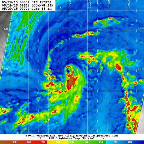
Core convection has been expanding in aerial coverage and intensity throughout the morning. I don't think there's any doubt this is a minimal hurricane at this point.
The intensity forecast is complicated. Shear has obviously been strong enough to derail what was otherwise an impressive bout of rapid intensification prior to yesterday evening. If this shear continues, only slow to steady strengthening can be expected, and I doubt Andres ever becomes a major hurricane. However, if this shear happens to slacken, I would not be surprised to see this quickly intensify. For now, I'm lowering my peak intensity forecast from the 110kt that I gave yesterday morning to 90kt.

The intensity forecast is complicated. Shear has obviously been strong enough to derail what was otherwise an impressive bout of rapid intensification prior to yesterday evening. If this shear continues, only slow to steady strengthening can be expected, and I doubt Andres ever becomes a major hurricane. However, if this shear happens to slacken, I would not be surprised to see this quickly intensify. For now, I'm lowering my peak intensity forecast from the 110kt that I gave yesterday morning to 90kt.
0 likes
-
Yellow Evan
- Professional-Met
- Posts: 16231
- Age: 27
- Joined: Fri Jul 15, 2011 12:48 pm
- Location: Henderson, Nevada/Honolulu, HI
- Contact:
-
TropicalAnalystwx13
- Category 5
- Posts: 2109
- Age: 28
- Joined: Tue Jul 19, 2011 8:20 pm
- Location: Wilmington, NC
- Contact:

-
Yellow Evan
- Professional-Met
- Posts: 16231
- Age: 27
- Joined: Fri Jul 15, 2011 12:48 pm
- Location: Henderson, Nevada/Honolulu, HI
- Contact:
-
cycloneye

- Admin

- Posts: 149275
- Age: 69
- Joined: Thu Oct 10, 2002 10:54 am
- Location: San Juan, Puerto Rico
Re: EPAC: ANDRES - Tropical Storm
First hurricane of 2015.
EP, 01, 2015052918, , BEST, 0, 126N, 1146W, 65, 990, HU
EP, 01, 2015052918, , BEST, 0, 126N, 1146W, 65, 990, HU
0 likes
Visit the Caribbean-Central America Weather Thread where you can find at first post web cams,radars
and observations from Caribbean basin members Click Here
and observations from Caribbean basin members Click Here
-
Yellow Evan
- Professional-Met
- Posts: 16231
- Age: 27
- Joined: Fri Jul 15, 2011 12:48 pm
- Location: Henderson, Nevada/Honolulu, HI
- Contact:
-
cycloneye
- Admin
- Posts: 149275
- Age: 69
- Joined: Thu Oct 10, 2002 10:54 am
- Location: San Juan, Puerto Rico
Re: EPAC: ANDRES - Hurricane
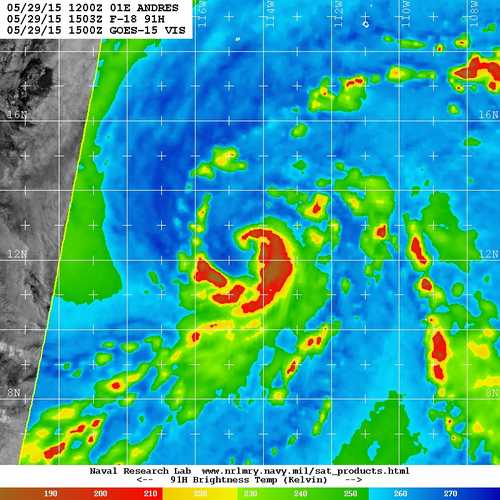
HURRICANE ANDRES DISCUSSION NUMBER 7
NWS NATIONAL HURRICANE CENTER MIAMI FL EP012015
300 PM MDT FRI MAY 29 2015
Convective banding features have increased since the previous
advisory, and a tight banding eye feature has occasionally appeared
in visible satellite imagery. Dvorak satellite estimates
are a consensus T4.0/65 kt from TAFB and SAB, and UW-CIMSS
ADT values are T4.3/72 kt. Based on these data, Andres has been
upgraded to a 65-kt hurricane.
Andres has made the anticipated turn toward the northwest, and the
initial motion estimate is now 310/06 kt. This general motion is
expected to continue for about the next 36-48 hours as the
hurricane moves around the western periphery of a deep-layer ridge
located across mainland Mexico and Baja California. The ridge is
forecast to gradually build westward during Days 3-5, forcing
Andres to turn back toward the west-northwest. The NHC model is in
excellent agreement on this developing scenario, and the guidance is
tightly clustered around the previous forecast track. As a result,
the official forecast track is just an update and extension of the
previous advisory track.
Despite moderate northerly vertical wind shear, Andres has
maintained a fairly impressive outflow pattern. However, the 850-200
mb vertical wind shear is forecast by the SHIPS model to increase to
around 16 kt during the next 24 hours, followed by decreasing shear
at 36 to 48 hours. Now that Andres has established better inner-core
convection and a possible eye feature, at least modest strengthening
should occur during the next 48 hours or so. Thereafter, decreasing
sea surface temperatures and cooler and more stable low-level air
lying just to the northwest of the hurricane should begin to affect
Andres. Visible satellite imagery already indicates that cold
air stratocumulus clouds are being advected into the northwestern
portion of the outer circulation, which should mitigate the
otherwise favorable thermodynamic conditions. As a result, a steady
decrease in the intensity should occur on Days 3-5, despite the low
vertical wind shear regime through which the cyclone will be moving.
The NHC intensity forecast is similar to the previous advisory, and
is above the intensity consensus model ICON and close to the SHIPS
model.
FORECAST POSITIONS AND MAX WINDS
INIT 29/2100Z 12.8N 114.8W 65 KT 75 MPH
12H 30/0600Z 13.6N 115.6W 70 KT 80 MPH
24H 30/1800Z 14.7N 116.6W 75 KT 85 MPH
36H 31/0600Z 15.7N 117.7W 80 KT 90 MPH
48H 31/1800Z 16.4N 119.1W 80 KT 90 MPH
72H 01/1800Z 17.4N 121.9W 65 KT 75 MPH
96H 02/1800Z 18.5N 125.4W 50 KT 60 MPH
120H 03/1800Z 18.8N 128.7W 40 KT 45 MPH
$$
Forecaster Stewart
0 likes
Visit the Caribbean-Central America Weather Thread where you can find at first post web cams,radars
and observations from Caribbean basin members Click Here
and observations from Caribbean basin members Click Here


-
Kingarabian

- S2K Supporter

- Posts: 16348
- Joined: Sat Aug 08, 2009 3:06 am
- Location: Honolulu, Hawaii
Not a knock on the NHC or anything (I'm sure they have their own valid reasons), it's weird that they just now cite ADT numbers. ADT numbers had hurricane numbers for nearly the past 24 hours.
I say this because the ADT was rock solid last year and was able to validate hurricane strengths correctly and earlier.
It's really great for RI and increasing numbers when necessary.
I say this because the ADT was rock solid last year and was able to validate hurricane strengths correctly and earlier.
It's really great for RI and increasing numbers when necessary.
0 likes
RIP Kobe Bryant
-
Yellow Evan
- Professional-Met
- Posts: 16231
- Age: 27
- Joined: Fri Jul 15, 2011 12:48 pm
- Location: Henderson, Nevada/Honolulu, HI
- Contact:
Re:
Kingarabian wrote:Not a knock on the NHC or anything (I'm sure they have their own valid reasons), it's weird that they just now cite ADT numbers. ADT numbers had hurricane numbers for nearly the past 24 hours.
I say this because the ADT was rock solid last year and was able to validate hurricane strengths correctly and earlier.
It's really great for RI and increasing numbers when necessary.
In fairness, ADT is oftentimes very off, especially the raw values.
0 likes
-
Kingarabian
- S2K Supporter
- Posts: 16348
- Joined: Sat Aug 08, 2009 3:06 am
- Location: Honolulu, Hawaii
Re: Re:
Yellow Evan wrote:Kingarabian wrote:Not a knock on the NHC or anything (I'm sure they have their own valid reasons), it's weird that they just now cite ADT numbers. ADT numbers had hurricane numbers for nearly the past 24 hours.
I say this because the ADT was rock solid last year and was able to validate hurricane strengths correctly and earlier.
It's really great for RI and increasing numbers when necessary.
In fairness, ADT is oftentimes very off, especially the raw values.
Understandable, but that's the live numbers and they will always be dynamic as the convection fluctuates. Large blowup of convection, you'll see it increase accordingly. Diminishing convection, you will see a decrease as well.
The final and adjusted numbers are usually spot on. I only look at the raw numbers for RI and rapid weakening.
Last edited by Kingarabian on Fri May 29, 2015 4:41 pm, edited 1 time in total.
0 likes
RIP Kobe Bryant
-
Yellow Evan
- Professional-Met
- Posts: 16231
- Age: 27
- Joined: Fri Jul 15, 2011 12:48 pm
- Location: Henderson, Nevada/Honolulu, HI
- Contact:
Re: Re:
Kingarabian wrote:
Understandable, but that's the live numbers and they will always be dynamic as the convection fluctuates. Large blowup of convection, you'll see it increase accordingly. Diminishing convection, you will see a decrease as well.
The final and adjusted numbers are usually spot on. I only look at the raw numbers for RI and rapid weakening.
Yea. Probs not used enough, I agree. But the older versions tended to be be more bullish, so in the forecasters eyes, it has that kind of reputation.
During the SHEM this year, I thought ADT from the JTWC was useful and the BOM did a great job using it.
ADT still has issues with center fixes though.
0 likes
-
Yellow Evan
- Professional-Met
- Posts: 16231
- Age: 27
- Joined: Fri Jul 15, 2011 12:48 pm
- Location: Henderson, Nevada/Honolulu, HI
- Contact:
Re: EPAC: ANDRES - Hurricane
Dry air still seems to be affecting it. Cloud tops cooling, so it's in the right direction.
0 likes
-
Yellow Evan
- Professional-Met
- Posts: 16231
- Age: 27
- Joined: Fri Jul 15, 2011 12:48 pm
- Location: Henderson, Nevada/Honolulu, HI
- Contact:
UW - CIMSS
ADVANCED DVORAK TECHNIQUE
ADT-Version 8.2.1
Tropical Cyclone Intensity Algorithm
----- Current Analysis -----
Date : 29 MAY 2015 Time : 210000 UTC
Lat : 12:48:00 N Lon : 114:48:00 W
CI# /Pressure/ Vmax
4.3 / 983.2mb/ 72.2kt
Final T# Adj T# Raw T#
4.3 4.5 4.5
Center Temp : -75.6C Cloud Region Temp : -75.6C
Scene Type : UNIFORM CDO CLOUD REGION
Positioning Method : FORECAST INTERPOLATION
Ocean Basin : EAST PACIFIC
Dvorak CI > MSLP Conversion Used : ATLANTIC
Tno/CI Rules : Constraint Limits : NO LIMIT
Weakening Flag : OFF
Rapid Dissipation Flag : OFF
C/K/Z MSLP Estimate Inputs :
- Average 34 knot radii : 62km
- Environmental MSLP : 1010mb
Satellite Name : GOES15
Satellite Viewing Angle : 27.8 degrees
0 likes
-
Yellow Evan
- Professional-Met
- Posts: 16231
- Age: 27
- Joined: Fri Jul 15, 2011 12:48 pm
- Location: Henderson, Nevada/Honolulu, HI
- Contact:
Who is online
Users browsing this forum: No registered users and 29 guests