Aric Dunn wrote:ozonepete wrote:Aric Dunn wrote:
alright to put this to an end. to be "right front" it has to be at a 90 degree angle otherwise it would not be right front its all relative directions.. see image below..
[img]http://s17.postimg.org/6ts6mo28f/wind_bln1.gif[img]
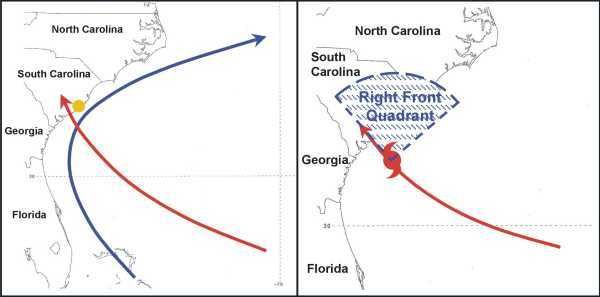
Ha ha you're agreeing with me. The area you outlined is the right front quadrant along the direction of motion which is what they teach in Meteo classes. That is not the NE or SE quadrant. If you insist on using directional compass terms it's the NNE-ESE quadrant. Why not just say right front?
Agreed on the quad part.. however the area that would have the theoretical maximum winds would be "ESE" of the center if moving NNE. Same concept two different relations.
to make it clearer, the right front with a nne motion would be from the ENE to SSE "quad" with the max possible winds at ESE. of course its not perfect in a hurricane to define an exact spot.. lol
SO outlined in yellow is the right front in this case. the red depicts the right angle ( or 90 degrees) to the forward motion not the actual right front quad in this case.

SouthDadeFish wrote:Aric, thanks for the diagram. That's what I was trying to get across. The theoretical location where the cyclonic winds align most with the motion vector is in the SE quadrant (technically ESE, as you say). Yes the right front quadrant features convective asymmetries and largest storm surge among other effects, but my point was where the motion vector was most aligned with the storm's primary circulation. Regardless, there are other factors at play such as the shear vector, potential land interaction, and the secondary eyewall itself. This isn't a textbook case.
Not a problem...


