ATL: ANA - Post-Tropical

Moderator: S2k Moderators

Message
Author
Brent
S2K Supporter
S2K Supporter
Posts: 37143
Age: 35
Joined: Sun May 16, 2004 10:30 pm
Location: Tulsa Oklahoma
Contact:

Re: Re:

#101 Postby Brent » Thu May 07, 2015 9:15 pm

RL3AO wrote:
CrazyC83 wrote:Never seen them do a pre-advisory declaration...that is new.


It makes sense. Being open about it on social media when the advisory package is being written makes more sense. It allows broadcasters to be ready for the 11pm EDT news instead of having the news break at 10:55 or whenever the advisory comes out.


I like it a lot.
0 likes   
#neversummer

User avatar
galaxy401
Category 5
Category 5
Posts: 2300
Age: 29
Joined: Sat Aug 25, 2012 9:04 pm
Location: Casa Grande, Arizona

#102 Postby galaxy401 » Thu May 07, 2015 9:32 pm

Last time we had Ana, we had to wait until August. Before that, it was April. Ana always comes early or late. :)
0 likes   
Got my eyes on moving right into Hurricane Alley: Florida.

HurricaneGonzalo
Tropical Wave
Tropical Wave
Posts: 3
Joined: Mon May 04, 2015 7:02 am

#103 Postby HurricaneGonzalo » Thu May 07, 2015 9:38 pm

Hi guys! I'm new here, and excited to get started. Ana looked similar to Hurricane Sandy this morning, anybody else notice that? It may take a path like a more southern version of TS Gabrielle (2007).
0 likes   

User avatar
TheStormExpert
Category 5
Category 5
Posts: 8487
Age: 30
Joined: Wed Feb 16, 2011 5:38 pm
Location: Palm Beach Gardens, FL

Re: Re:

#104 Postby TheStormExpert » Thu May 07, 2015 10:01 pm

RL3AO wrote:
CrazyC83 wrote:Never seen them do a pre-advisory declaration...that is new.


It makes sense. Being open about it on social media when the advisory package is being written makes more sense. It allows broadcasters to be ready for the 11pm EDT news instead of having the news break at 10:55 or whenever the advisory comes out.

Yeah, it always seemed like they would be rushing to get the information in and update the graphics in a timely manner. This is perfect, hope it continues.
0 likes   
The following post is NOT an official forecast and should not be used as such. It is just the opinion of the poster and may or may not be backed by sound meteorological data. It is NOT endorsed by storm2k.org.

User avatar
TheStormExpert
Category 5
Category 5
Posts: 8487
Age: 30
Joined: Wed Feb 16, 2011 5:38 pm
Location: Palm Beach Gardens, FL

#105 Postby TheStormExpert » Thu May 07, 2015 10:05 pm

This is also the second season in a row where the first named storm forms off the SE U.S. Coast.

My guess is once again off the SE U.S. Coast and the West Atlantic will be the hotspot or in this seasons particular case MDR.

Also, when was the last Tropical Cyclone to make landfall in South Carolina? Since this has the potential to do so too.
0 likes   
The following post is NOT an official forecast and should not be used as such. It is just the opinion of the poster and may or may not be backed by sound meteorological data. It is NOT endorsed by storm2k.org.

User avatar
JtSmarts
S2K Supporter
S2K Supporter
Posts: 1422
Age: 38
Joined: Thu Jul 10, 2003 1:29 pm
Location: Columbia, South Carolina

Re:

#106 Postby JtSmarts » Thu May 07, 2015 10:09 pm

TheStormExpert wrote:This is also the second season in a row where the first named storm forms off the SE U.S. Coast.

My guess is once again off the SE U.S. Coast and the West Atlantic will be the hotspot or in this seasons particular case MDR.

Also, when was the last Tropical Cyclone to make landfall in South Carolina? Since this has the potential to do so too.


The last storm to make landfall in SC was either Gaston 2004 or Hanna 2008 I believe.
0 likes   

User avatar
Hammy
Category 5
Category 5
Posts: 5594
Age: 40
Joined: Fri May 25, 2012 5:25 pm
Contact:

Re:

#107 Postby Hammy » Thu May 07, 2015 10:10 pm

TheStormExpert wrote:Also, when was the last Tropical Cyclone to make landfall in South Carolina? Since this has the potential to do so too.


Gaston in 2004, though Hanna in 2008 made landfall along the border (but may have been in NC)
0 likes   
The above post is not official and should not be used as such. It is the opinion of the poster and may or may not be backed by sound meteorological data. It is not endorsed by any professional institution or storm2k.org. For official information, please refer to the NHC and NWS products.

HurricaneGonzalo
Tropical Wave
Tropical Wave
Posts: 3
Joined: Mon May 04, 2015 7:02 am

Re:

#108 Postby HurricaneGonzalo » Thu May 07, 2015 10:12 pm

TheStormExpert wrote:This is also the second season in a row where the first named storm forms off the SE U.S. Coast.

My guess is once again off the SE U.S. Coast and the West Atlantic will be the hotspot or in this seasons particular case MDR.

Also, when was the last Tropical Cyclone to make landfall in South Carolina? Since this has the potential to do so too.

I think Hurricane Hanna (2008).
0 likes   

User avatar
Andrew92
S2K Supporter
S2K Supporter
Posts: 3247
Age: 40
Joined: Mon Jun 16, 2003 12:35 am
Location: Phoenix, Arizona

#109 Postby Andrew92 » Thu May 07, 2015 10:13 pm

The following post is NOT an official forecast and should not be used as such. It is just the opinion of the poster and may or may not be backed by sound meteorological data. It is NOT endorsed by any professional institution or storm2k.org. For official information, please refer to the NHC and NWS products.

I like the pre-advisory declarations also. Maybe one more suggestion would be to get any watches and warnings to the public first before the full advisory comes, if they know where they will be issued. Then again, maybe I'm being nit-picky.

In any event, here we go! This storm draws a lot of similarities to Beryl in 2012, but I have a little difficult time seeing this get as strong as 65-70 mph. I don't see much indicating there is an unfavorable atmosphere aloft, with little shear present. The problem is the water is just not warm enough, which isn't surprising since it is May after all. I do think this will become a tropical storm though, perhaps reaching 60 mph for a brief period of time before weakening as it approaches the coast during the weekend. I suggest a little higher than what the forecast says because (a) intensity forecasts are the trickiest to predict, (b) it will have a little bit of time over reasonably warm water for that intensity, in my opinion, if it moves about as slow as forecast, and (c) it already looks reasonably well-organized for a subtropical storm and is working on getting better organized, it appears.

The big problem in the Carolinas will be heavy rain. Fortunately, after landfall, it appears Ana will hopefully move a bit faster, but flooding is always a concern with these storms. So stay dry everyone in the path of this storm! Here is hoping the rain doesn't become a major issue this time around.

-Andrew92
0 likes   

User avatar
TheStormExpert
Category 5
Category 5
Posts: 8487
Age: 30
Joined: Wed Feb 16, 2011 5:38 pm
Location: Palm Beach Gardens, FL

Re: Re:

#110 Postby TheStormExpert » Thu May 07, 2015 10:18 pm

Hammy wrote:
TheStormExpert wrote:Also, when was the last Tropical Cyclone to make landfall in South Carolina? Since this has the potential to do so too.


Gaston in 2004, though Hanna in 2008 made landfall along the border (but may have been in NC)

Yeah TS Hanna his North Myrtle Beach, SC with winds of 70mph approaching from the SSW. Though Hurricane Gaston is probably the best and almost identical storm in terms of potential storm track.
0 likes   
The following post is NOT an official forecast and should not be used as such. It is just the opinion of the poster and may or may not be backed by sound meteorological data. It is NOT endorsed by storm2k.org.

User avatar
JtSmarts
S2K Supporter
S2K Supporter
Posts: 1422
Age: 38
Joined: Thu Jul 10, 2003 1:29 pm
Location: Columbia, South Carolina

#111 Postby JtSmarts » Thu May 07, 2015 10:23 pm

I'm glad it's May because this same track moving slowly in Aug/Sept would possibly be a major problem.
0 likes   

windnrain
Category 2
Category 2
Posts: 670
Joined: Wed Aug 10, 2005 1:19 pm
Location: Baton Rouge

#112 Postby windnrain » Thu May 07, 2015 10:28 pm

Man, that happened quickly! We will likely get our first landfall before May 10th!
0 likes   

psyclone
S2K Supporter
S2K Supporter
Posts: 4510
Joined: Wed Aug 24, 2005 9:04 pm
Location: palm harbor fl

#113 Postby psyclone » Thu May 07, 2015 10:30 pm

This system is delivering exquisite weather to Florida...the dewpoint in Tampa is 60 and we owe it to the dry northwest flow around Ana. Between this and a big SVRWX outbreak in tornado alley weather fans will have plenty to look at the next few days.
0 likes   

User avatar
TheStormExpert
Category 5
Category 5
Posts: 8487
Age: 30
Joined: Wed Feb 16, 2011 5:38 pm
Location: Palm Beach Gardens, FL

Re:

#114 Postby TheStormExpert » Thu May 07, 2015 10:36 pm

JtSmarts wrote:I'm glad it's May because this same track moving slowly in Aug/Sept would possibly be a major problem.

Yeah luckily it's not or else we could be dealing with a repeat of Hurricane Gaston(2004) or worse!

Hurricane Gaston is a perfect analog storm track-wise, I mean look at how similar the two tracks are with the first advisory of STS Ana.

Hopefully this is not a precursor of things to come. :eek:

STS Ana: Advisory #1 :darrow:
Image

Gaston: Advisory #1 :darrow:
Image

Hurricane Gaston: Storm Track :darrow:
Image
0 likes   
The following post is NOT an official forecast and should not be used as such. It is just the opinion of the poster and may or may not be backed by sound meteorological data. It is NOT endorsed by storm2k.org.

User avatar
Andrew92
S2K Supporter
S2K Supporter
Posts: 3247
Age: 40
Joined: Mon Jun 16, 2003 12:35 am
Location: Phoenix, Arizona

Re: Re:

#115 Postby Andrew92 » Thu May 07, 2015 10:55 pm

The following post is NOT an official forecast and should not be used as such. It is just the opinion of the poster and may or may not be backed by sound meteorological data. It is NOT endorsed by any professional institution or storm2k.org. For official information, please refer to the NHC and NWS products.

TheStormExpert wrote:
JtSmarts wrote:I'm glad it's May because this same track moving slowly in Aug/Sept would possibly be a major problem.

Yeah luckily it's not or else we could be dealing with a repeat of Hurricane Gaston(2004) or worse!

Hurricane Gaston is a perfect analog storm track-wise, I mean look at how similar the two tracks are with the first advisory of STS Ana.

Hopefully this is not a precursor of things to come. :eek:


It is an El Nino year still, and we have had seasons with activity this early turn out not to have too much activity. The best example of that would be 1997, which had a subtropical storm at about the typical beginning of the hurricane season. That was followed a month later by three more storms off the East Coast, with one briefly becoming a hurricane, and then a Gulf hurricane.

But then that season quickly became a dud. Only three storms after that, with one major hurricane in there.

I must say though, I have my doubts that this will be the only threat to the US this year. I could also maybe see a 2002-like scenario, with high quantity of storms relative for an El Nino, but very low quality overall. But I don't think this storm will be too much of a sign of things to come for the season as a whole. But we'll find out as we progress through!

-Andrew92
0 likes   

User avatar
NDG
S2K Supporter
S2K Supporter
Posts: 14947
Joined: Sun Jul 09, 2006 10:14 pm
Location: Orlando, FL

Re: ATL: ANA - Subtropical Storm

#116 Postby NDG » Fri May 08, 2015 6:30 am

Image
0 likes   

xironman
S2K Supporter
S2K Supporter
Posts: 2159
Joined: Sun Jun 10, 2007 4:53 pm
Location: NoVA

Re: ATL: ANA - Subtropical Storm

#117 Postby xironman » Fri May 08, 2015 6:33 am

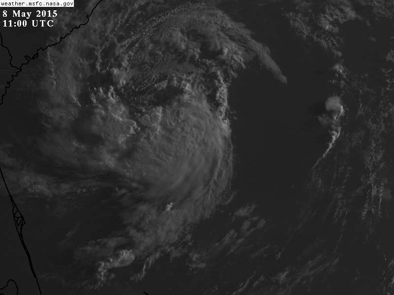
Recon shows the winds radii have contracted, warmer in the center as well. I think they go with plain TS @11.


The posts in this forum are NOT official forecast and should not be used as such. They are just the opinion of the poster and may or may not be backed by sound meteorological data. They are NOT endorsed by any professional institution or storm2k.org. For official information, please refer to the NHC and NWS products
0 likes   

User avatar
TheStormExpert
Category 5
Category 5
Posts: 8487
Age: 30
Joined: Wed Feb 16, 2011 5:38 pm
Location: Palm Beach Gardens, FL

#118 Postby TheStormExpert » Fri May 08, 2015 6:37 am

Still a good bit of dry air surrounding it.
0 likes   
The following post is NOT an official forecast and should not be used as such. It is just the opinion of the poster and may or may not be backed by sound meteorological data. It is NOT endorsed by storm2k.org.

User avatar
Nimbus
Category 5
Category 5
Posts: 4933
Joined: Mon Jul 19, 2004 10:54 am

Re: ATL: ANA - Subtropical Storm

#119 Postby Nimbus » Fri May 08, 2015 6:41 am

Still a lot of dry air intrusion but a neat little storm for the preseason.
0 likes   

User avatar
wxman57
Moderator-Pro Met
Moderator-Pro Met
Posts: 22506
Age: 66
Joined: Sat Jun 21, 2003 8:06 pm
Location: Houston, TX (southwest)

Re: ATL: ANA - Subtropical Storm

#120 Postby wxman57 » Fri May 08, 2015 6:41 am

So far, the plane isn't finding winds to be as strong as yesterday afternoon. They appear to support 35 kts, though.
0 likes   


Return to “2015”

Who is online

Users browsing this forum: No registered users and 9 guests