WPAC: HAIYAN - Post-Tropical

Moderator: S2k Moderators

Message
Author
User avatar
galaxy401
Category 5
Category 5
Posts: 2419
Age: 30
Joined: Sat Aug 25, 2012 9:04 pm
Location: Casa Grande, Arizona

Re: WPAC: HAIYAN - Typhoon

#921 Postby galaxy401 » Thu Nov 07, 2013 7:23 pm

supercane4867 wrote:Image


That seriously the same camera?! That is a lot of destruction! :eek:
0 likes   
Got my eyes on moving right into Hurricane Alley: Florida.

User avatar
FireRat
Category 5
Category 5
Posts: 1246
Age: 38
Joined: Sun Sep 26, 2010 11:38 pm
Location: North Carolina

Re: WPAC: HAIYAN - Typhoon

#922 Postby FireRat » Thu Nov 07, 2013 7:24 pm

EquusStorm wrote:Doesn't get much scarier than this.
Image

Also, I believe Camille's landfall wind to be a bit overestimated (its 190 peak was probably offshore, weakening before landfall according to a rather detailed analysis of wind damage at the coast) but the 1935 Labor Day storm is probably this storm's closest landfall intensity 'cousin'.


THAT IS ABSOLUTELY AMAZING! Thanks for the loop! It immediately reminded me of SuperTyphoon Nida of 2009, which looked just like that in that same satellite imagery type while out over the open waters on Nov. 25 2009. Also, that one was one rumored to have been among the strongest ever seen, and now we get a very similar-looking monster STRIKING LAND!! I guess now we'll know better how the Satellite appearance as well as Dvorak correlates to the storm's actual power. Surely the greatest typhoon ever to make landfall in the modern era, will be a subject of much research in years to come IMO.
0 likes   
Georges '98, Irene '99, Frances '04, Jeanne '04, Katrina '05, Wilma '05, Gustav '08, Isaac '12, Matthew '16, Florence '18, Michael '18, Ian '22

User avatar
xtyphooncyclonex
Category 5
Category 5
Posts: 3861
Age: 23
Joined: Sat Dec 08, 2012 9:07 am
Location: Cebu City
Contact:

#923 Postby xtyphooncyclonex » Thu Nov 07, 2013 7:25 pm

JTWC says it is moving to the west.
0 likes   
REMINDER: My opinions that I, or any other NON Pro-Met in this forum, are unofficial. Please do not take my opinions as an official forecast and warning. I am NOT a meteorologist. Following my forecasts blindly may lead to false alarm, danger and risk if official forecasts from agencies are ignored.

stormkite
S2K Supporter
S2K Supporter
Posts: 672
Joined: Fri Sep 13, 2013 3:59 am

#924 Postby stormkite » Thu Nov 07, 2013 7:26 pm

xtyphooncyclonex praying for you and your family to be safe.
0 likes   

thoughtsinchaos
Tropical Low
Tropical Low
Posts: 27
Joined: Thu Sep 09, 2010 4:31 pm
Location: Los Angeles (UCLA)
Contact:

Re: WPAC: HAIYAN - Typhoon

#925 Postby thoughtsinchaos » Thu Nov 07, 2013 7:26 pm

Just kidding, Cebu radar went back online again. Structure of the core seems to have deteriorated significantly, but I'm not sure if that's just from radar blocking/interference.

Image
0 likes   

User avatar
PaulR
Tropical Depression
Tropical Depression
Posts: 70
Joined: Mon Dec 03, 2012 2:43 pm
Location: Mid-South USA

Re: WPAC: HAIYAN - Typhoon

#926 Postby PaulR » Thu Nov 07, 2013 7:27 pm

supercane4867 wrote:I'm seeing Katrina-ish storm surge :double:


Links? Pics? Data?

(I know I don't have a lot to contribute, but I like to ask!)
0 likes   
"Normal" is Chicago under a mile of ice.

dexterlabio
Category 5
Category 5
Posts: 3468
Joined: Sat Oct 24, 2009 11:50 pm

Re: WPAC: HAIYAN - Typhoon

#927 Postby dexterlabio » Thu Nov 07, 2013 7:27 pm

My roommate's relatives sent a message and he is from Camiguin. They are reporting intense winds and the power has already been cut off in that place. How far is Camiguin from the point of landfall? I am not familiar with Visayas' geography. Thanks.
0 likes   
Personal Forecast Disclaimer:
The posts in this forum are NOT official forecast and should not be used as such. They are just the opinion of the poster and may or may not be backed by sound meteorological data. They are NOT endorsed by any professional institution or storm2k.org. For official information, please refer to the NHC and NWS products.

Sanibel
Category 5
Category 5
Posts: 10375
Joined: Mon Aug 30, 2004 11:06 pm
Location: Offshore SW Florida

Re: WPAC: HAIYAN - Typhoon

#928 Postby Sanibel » Thu Nov 07, 2013 7:27 pm

It's going over mountains.


Camiguin is 200 miles to the south.
Last edited by Sanibel on Thu Nov 07, 2013 7:30 pm, edited 1 time in total.
0 likes   

User avatar
Crostorm
Category 5
Category 5
Posts: 2060
Age: 50
Joined: Mon Dec 25, 2006 3:51 pm
Location: Croatia-Europe
Contact:

Re: WPAC: HAIYAN - Typhoon

#929 Postby Crostorm » Thu Nov 07, 2013 7:29 pm

Radar animation

Image
0 likes   

hurricanes1234
Category 5
Category 5
Posts: 2907
Joined: Sat Jul 28, 2012 6:19 pm
Location: Trinidad and Tobago

Re: WPAC: HAIYAN - Typhoon

#930 Postby hurricanes1234 » Thu Nov 07, 2013 7:31 pm

That damage in the span of half an hour is simply absurd. I am beginning to wonder if they'll recover anytime soon from this. :eek:
0 likes   
PLEASE NOTE: With the exception of information from weather agencies that I may copy and paste here, my posts will NEVER be official, since I am NOT a meteorologist. They are solely my amateur opinion, and may or may not be accurate. Therefore, please DO NOT use them as official details, particularly when making important decisions. Thank you.

User avatar
cycloneye
Admin
Admin
Posts: 145354
Age: 68
Joined: Thu Oct 10, 2002 10:54 am
Location: San Juan, Puerto Rico

Re: WPAC: HAIYAN - Typhoon

#931 Postby cycloneye » Thu Nov 07, 2013 7:32 pm

00z Best Track down to 160kts.

31W HAIYAN 131108 0000 11.0N 124.8E WPAC 160 903
0 likes   
Visit the Caribbean-Central America Weather Thread where you can find at first post web cams,radars
and observations from Caribbean basin members Click Here

CrazyC83
Professional-Met
Professional-Met
Posts: 34002
Joined: Tue Mar 07, 2006 11:57 pm
Location: Deep South, for the first time!

Re: WPAC: HAIYAN - Typhoon

#932 Postby CrazyC83 » Thu Nov 07, 2013 7:37 pm

It is still likely that Haiyan will be at least a Cat 4 once it emerges over water...after crossing mountains...amazing.
0 likes   

hurricanes1234
Category 5
Category 5
Posts: 2907
Joined: Sat Jul 28, 2012 6:19 pm
Location: Trinidad and Tobago

Re: WPAC: HAIYAN - Typhoon

#933 Postby hurricanes1234 » Thu Nov 07, 2013 7:38 pm

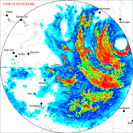
cycloneye wrote:00z Best Track down to 160kts.

31W HAIYAN 131108 0000 11.0N 124.8E WPAC 160 903


It's weakened because of land interaction. I'd say it peaked at around 19:30 UTC today. Glad it's weakened. Because that damage in the span of one hour seems like a horrible dream.
0 likes   
PLEASE NOTE: With the exception of information from weather agencies that I may copy and paste here, my posts will NEVER be official, since I am NOT a meteorologist. They are solely my amateur opinion, and may or may not be accurate. Therefore, please DO NOT use them as official details, particularly when making important decisions. Thank you.

User avatar
cycloneye
Admin
Admin
Posts: 145354
Age: 68
Joined: Thu Oct 10, 2002 10:54 am
Location: San Juan, Puerto Rico

Re: WPAC: HAIYAN - Typhoon

#934 Postby cycloneye » Thu Nov 07, 2013 7:38 pm

For those who may be coming tonight for the first time to this thread,I documented in the first post of this thread the historic moment when Haiyan was at 170kts and at landfall.

viewtopic.php?f=76&t=115958&hilit=&start=0
0 likes   
Visit the Caribbean-Central America Weather Thread where you can find at first post web cams,radars
and observations from Caribbean basin members Click Here

User avatar
Fyzn94
Tropical Storm
Tropical Storm
Posts: 190
Joined: Thu Jul 07, 2011 10:00 pm
Location: Central AR, USA

Re: WPAC: HAIYAN - Typhoon

#935 Postby Fyzn94 » Thu Nov 07, 2013 7:41 pm

galaxy401 wrote:
supercane4867 wrote:Image


That seriously the same camera?! That is a lot of destruction! :eek:

195 mph.....might as well have been a giant EF4/5 tornado
0 likes   
NOTICE: I cannot give an expert analysis. Most of my "observations" are made visually with the help of only vital information provided by public advisories.

hurricanes1234
Category 5
Category 5
Posts: 2907
Joined: Sat Jul 28, 2012 6:19 pm
Location: Trinidad and Tobago

Re: WPAC: HAIYAN - Typhoon

#936 Postby hurricanes1234 » Thu Nov 07, 2013 7:42 pm

This will definitely make history. Please note that it is the strongest landfall anywhere on Earth ever recorded. I think it's also the first sub-900 mbar landfall.
0 likes   
PLEASE NOTE: With the exception of information from weather agencies that I may copy and paste here, my posts will NEVER be official, since I am NOT a meteorologist. They are solely my amateur opinion, and may or may not be accurate. Therefore, please DO NOT use them as official details, particularly when making important decisions. Thank you.

CrazyC83
Professional-Met
Professional-Met
Posts: 34002
Joined: Tue Mar 07, 2006 11:57 pm
Location: Deep South, for the first time!

Re: WPAC: HAIYAN - Typhoon

#937 Postby CrazyC83 » Thu Nov 07, 2013 7:43 pm

Fyzn94 wrote:
galaxy401 wrote:
supercane4867 wrote:Image


That seriously the same camera?! That is a lot of destruction! :eek:

195 mph.....might as well have been a giant EF4/5 tornado


Video analyses suggested that (at least the time they were taken) the winds weren't nearly that strong, perhaps gusts to 110 mph or so. That looks to be tsunami-like storm surge damage.
0 likes   

RL3AO
Moderator-Pro Met
Moderator-Pro Met
Posts: 16308
Joined: Thu Jun 14, 2007 10:03 pm
Location: NC

Re: WPAC: HAIYAN - Typhoon

#938 Postby RL3AO » Thu Nov 07, 2013 7:44 pm

hurricanes1234 wrote:This will definitely make history. Please note that it is the strongest landfall anywhere on Earth ever recorded. I think it's also the first sub-900 mbar landfall.


We don't know either of those. Everything was satellite estimated.
0 likes   

Alyono
Professional-Met
Professional-Met
Posts: 6961
Joined: Fri Apr 26, 2013 3:52 pm
Location: Texas Coast

#939 Postby Alyono » Thu Nov 07, 2013 7:44 pm

Tacloban missed the eyewall is why the highest winds were not observed there
0 likes   

CrazyC83
Professional-Met
Professional-Met
Posts: 34002
Joined: Tue Mar 07, 2006 11:57 pm
Location: Deep South, for the first time!

Re: WPAC: HAIYAN - Typhoon

#940 Postby CrazyC83 » Thu Nov 07, 2013 7:46 pm

RL3AO wrote:
hurricanes1234 wrote:This will definitely make history. Please note that it is the strongest landfall anywhere on Earth ever recorded. I think it's also the first sub-900 mbar landfall.


We don't know either of those. Everything was satellite estimated.


The latter is definitely not true - the 1935 Labor Day hurricane made landfall at 892mb.
0 likes   


Return to “2013”

Who is online

Users browsing this forum: No registered users and 5 guests