ATL: INVEST 92L - Discussion

Moderator: S2k Moderators

Message
Author
ozonepete
Professional-Met
Professional-Met
Posts: 4743
Joined: Mon Sep 07, 2009 3:23 pm
Location: From Ozone Park, NYC / Now in Brooklyn, NY

Re:

#721 Postby ozonepete » Fri Aug 16, 2013 4:53 pm

BigA wrote:Taking a closer look, it makes sense that the LLC is dissipating, while the overall large-scale circulation remains. Looking at the 850 vorticity map, the vorticity over the circulation hasn't weakened. However, that is satellite-derived and likely unable to pick out small-scale changes such as the weakening of the small LLC. Once (if?) the upper-level low weakens, I like 92's chances as long as it moves more west than north in the short run.


Very important point there about the fact that those vorticity charts are satellite derived and can change very quickly. This scenario is a perfect example. IMO the ULL is just about done. From the water vapor loops it looks like it droped slowly southwestward today and the last of it finally got elongated and dissipated just in the last few frames. One of the last things it contributed to this whole scenario was that the southwest to south winds on the southern side of it helped shift the vorticity in the system more northward. I would think the vorticity charts over the next few hours will start showing this northward shift in the vort max from 850mb to 500mb.
0 likes   

User avatar
Portastorm
Storm2k Moderator
Storm2k Moderator
Posts: 9914
Age: 63
Joined: Fri Jul 11, 2003 9:16 am
Location: Round Rock, TX
Contact:

Re: ATL: INVEST 92L - Discussion

#722 Postby Portastorm » Fri Aug 16, 2013 4:53 pm

Our pro mets watching this system -- wxman57, ozonepete, and Alyono -- have said it best. There is no clear-cut LLC right now. Watch the broad low until a more clear center makes its presence known.
0 likes   
Any forecasts under my name are to be taken with a grain of salt. Get your best forecasts from the National Weather Service and National Hurricane Center.

User avatar
Kludge
S2K Supporter
S2K Supporter
Posts: 215
Joined: Thu Aug 26, 2004 9:03 pm
Location: Montgomery, Texas

Re:

#723 Postby Kludge » Fri Aug 16, 2013 4:54 pm

Dean4Storms wrote:Evidently the Mobile NWS office see's what I was talking about earlier about a circulation moving northward toward the upper Gulf Coast.

From this afternoons AFD....

.MARINE...A WEAK SURFACE CIRCULATION OVER THE NORTH-CENTRAL GULF
COAST WILL ERODE TONIGHT AS A SURFACE CIRCULATION FORMS OVER THE
SOUTHERN GULF OF MEX AND MOVES NORTH. THIS CIRCULATION WILL MOVE
ONSHORE ON THE LOUISIANA COAST SATURDAY NIGHT INTO SUNDAY. MODERATE
TO AT TIMES STRONG ONSHORE FLOW IS EXPECTED TO MOVE OVER AREA
COASTAL WATERS SATURDAY INTO SATURDAY NIGHT. AM NOT EXPECTING MORE
THAN EX CAUTION LEVEL WINDS/SEAS ATTM...THOUGH DEPENDING UPON HOW
THE SYSTEM DEVELOPS AND MOVES NORTH IS STILL IN FLUX.


Let's all stop guessing at what may happen. NWS Mobile seems to have "inside information", so let's just let them tell us what will happen. :roll: :D
0 likes   

HurriGuy
S2K Supporter
S2K Supporter
Posts: 734
Joined: Thu Aug 15, 2013 8:43 pm
Location: Prairieville, LA

#724 Postby HurriGuy » Fri Aug 16, 2013 4:54 pm

Just looking at the 12z 48 hour GFS sheer forecast, it does not show much sheer in the northern Gulf. Looks to be in the 12-16 knot range. That isn't going to kill this system I would think.
0 likes   
The posts in this forum are NOT official forecast and should not be used as such. They are just the opinion of the poster and may or may not be backed by sound meteorological data. They are NOT endorsed by any professional institution or storm2k.org. For official information, please refer to the NHC and NWS products.

bella_may
Category 4
Category 4
Posts: 908
Joined: Wed Dec 22, 2010 2:13 pm
Location: SE Mississippi coast

Re: Re:

#725 Postby bella_may » Fri Aug 16, 2013 5:00 pm

Kludge wrote:
Dean4Storms wrote:Evidently the Mobile NWS office see's what I was talking about earlier about a circulation moving northward toward the upper Gulf Coast.

From this afternoons AFD....

.MARINE...A WEAK SURFACE CIRCULATION OVER THE NORTH-CENTRAL GULF
COAST WILL ERODE TONIGHT AS A SURFACE CIRCULATION FORMS OVER THE
SOUTHERN GULF OF MEX AND MOVES NORTH. THIS CIRCULATION WILL MOVE
ONSHORE ON THE LOUISIANA COAST SATURDAY NIGHT INTO SUNDAY. MODERATE
TO AT TIMES STRONG ONSHORE FLOW IS EXPECTED TO MOVE OVER AREA
COASTAL WATERS SATURDAY INTO SATURDAY NIGHT. AM NOT EXPECTING MORE
THAN EX CAUTION LEVEL WINDS/SEAS ATTM...THOUGH DEPENDING UPON HOW
THE SYSTEM DEVELOPS AND MOVES NORTH IS STILL IN FLUX.


Let's all stop guessing at what may happen. NWS Mobile seems to have "inside information", so let's just let them tell us what will happen. :roll: :D


I think the NWS knows more than we do. :wink:
0 likes   

User avatar
MGC
S2K Supporter
S2K Supporter
Posts: 5899
Joined: Sun Mar 23, 2003 9:05 pm
Location: Pass Christian MS, or what is left.

Re: ATL: INVEST 92L - Discussion

#726 Postby MGC » Fri Aug 16, 2013 5:00 pm

I only see the ULL and surface low...they appear to be displaced a few degrees, so they are not vertically aligned. Surface low looks to be nearly stationary. I have no idea where this mess will end up. Models are flip-floping like a fish out of water. I'm thinking the surface low will slowly die out and a new surface low will form near the convection. Surface low and upper low merge and it becomes a TC.....too far fetched? I don't know......MGC

The above is the opinion of MGC and not an official forecast.
0 likes   

Dean4Storms
S2K Supporter
S2K Supporter
Posts: 6358
Age: 62
Joined: Sun Aug 31, 2003 1:01 pm
Location: Miramar Bch. FL

Re: Re:

#727 Postby Dean4Storms » Fri Aug 16, 2013 5:01 pm

Kludge wrote:
Dean4Storms wrote:Evidently the Mobile NWS office see's what I was talking about earlier about a circulation moving northward toward the upper Gulf Coast.

From this afternoons AFD....

.MARINE...A WEAK SURFACE CIRCULATION OVER THE NORTH-CENTRAL GULF
COAST WILL ERODE TONIGHT AS A SURFACE CIRCULATION FORMS OVER THE
SOUTHERN GULF OF MEX AND MOVES NORTH. THIS CIRCULATION WILL MOVE
ONSHORE ON THE LOUISIANA COAST SATURDAY NIGHT INTO SUNDAY. MODERATE
TO AT TIMES STRONG ONSHORE FLOW IS EXPECTED TO MOVE OVER AREA
COASTAL WATERS SATURDAY INTO SATURDAY NIGHT. AM NOT EXPECTING MORE
THAN EX CAUTION LEVEL WINDS/SEAS ATTM...THOUGH DEPENDING UPON HOW
THE SYSTEM DEVELOPS AND MOVES NORTH IS STILL IN FLUX.


Let's all stop guessing at what may happen. NWS Mobile seems to have "inside information", so let's just let them tell us what will happen. :roll: :D


I wasn't guessing, I actually posted the 12z GFS 850mb Vort charts showing the Vort with it moving north and it eventually in 36 hours (Sat. Evening) off the SE coast of LA. Had nothing to do with the Convectionless Low spinning off to the west of the Yucatan. I also saw early this morning (3am) when there was no convection along the north coast of the Yucatan a small circulation that moved NNW to a position now somewhere under the convection close to 23N 89.5W or thereabout. I lost it around dawn as the convection popped all around it. I believe it was an MLC at the time never said it was at the surface though.
Last edited by Dean4Storms on Fri Aug 16, 2013 5:08 pm, edited 1 time in total.
0 likes   

User avatar
HouTXmetro
Category 5
Category 5
Posts: 3949
Joined: Sun Jun 13, 2004 6:00 pm
Location: District of Columbia, USA

Re: Re:

#728 Postby HouTXmetro » Fri Aug 16, 2013 5:06 pm

ozonepete wrote:
BigA wrote:Taking a closer look, it makes sense that the LLC is dissipating, while the overall large-scale circulation remains. Looking at the 850 vorticity map, the vorticity over the circulation hasn't weakened. However, that is satellite-derived and likely unable to pick out small-scale changes such as the weakening of the small LLC. Once (if?) the upper-level low weakens, I like 92's chances as long as it moves more west than north in the short run.


Very important point there about the fact that those vorticity charts are satellite derived and can change very quickly. This scenario is a perfect example. IMO the ULL is just about done. From the water vapor loops it looks like it droped slowly southwestward today and the last of it finally got elongated and dissipated just in the last few frames. One of the last things it contributed to this whole scenario was that the southwest to south winds on the southern side of it helped shift the vorticity in the system more northward. I would think the vorticity charts over the next few hours will start showing this northward shift in the vort max from 850mb to 500mb.


Not to nit-pick but I been studying that Water Vapor Loop all day. That is the same ULL from this Morning that convection is wrapping around. Has it changed or worked its way down more, I don't know. But trust me. That is the same ULL from this morning.

http://www.ssd.noaa.gov/goes/east/gmex/flash-wv.html
0 likes   
[Disclaimer: My Amateur Opinion, please defer to your local authorities or the NHC for Guidance.]

User avatar
wxman57
Moderator-Pro Met
Moderator-Pro Met
Posts: 22978
Age: 67
Joined: Sat Jun 21, 2003 8:06 pm
Location: Houston, TX (southwest)

Re: ATL: INVEST 92L - Discussion

#729 Postby wxman57 » Fri Aug 16, 2013 5:06 pm

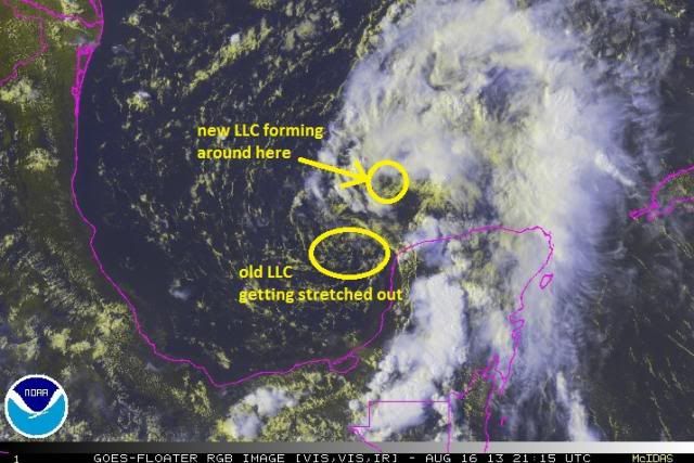
I'd say another LLC is forming closer to 22.5N/90.6W. Squalls are streaming northward along 90W, so it's not east of there. I certainly wouldn't rule out it being picked up and taken northward. Follow the convection. Currently, the convection is streaming N-NNE.
0 likes   

HurriGuy
S2K Supporter
S2K Supporter
Posts: 734
Joined: Thu Aug 15, 2013 8:43 pm
Location: Prairieville, LA

#730 Postby HurriGuy » Fri Aug 16, 2013 5:08 pm

Last couple of frames of the Water Vapor loop look to favor this system. It's really getting hard to see that ULL.
0 likes   
The posts in this forum are NOT official forecast and should not be used as such. They are just the opinion of the poster and may or may not be backed by sound meteorological data. They are NOT endorsed by any professional institution or storm2k.org. For official information, please refer to the NHC and NWS products.

User avatar
Kludge
S2K Supporter
S2K Supporter
Posts: 215
Joined: Thu Aug 26, 2004 9:03 pm
Location: Montgomery, Texas

Re: Re:

#731 Postby Kludge » Fri Aug 16, 2013 5:12 pm

[quote="Dean4Storms]I wasn't guessing, I actually posted the 12z GFS 850mb Vort charts showing the Vort with it moving north and it eventually in 36 hours (Sat. Evening) off the SE coast of LA. Had nothing to do with the Convectionless Low spinning off to the west of the Yucatan. I also saw early this morning (3am) when there was no convection along the north coast of the Yucatan a small circulation that moved NNW to a position now somewhere under the convection close to 23N 89.5W or thereabout. I lost it around dawn as the convection popped all around it. I believe it was an MLC at the time never said it was at the surface though.[/quote]

I didn't mean to infer you were "guessing". You were offering your informed opinion, which I very much appreciate. But I don't appreciate any human saying will when it comes to weather.

Sorry for the sidebar... now back to what may happen with 92L.
0 likes   

ozonepete
Professional-Met
Professional-Met
Posts: 4743
Joined: Mon Sep 07, 2009 3:23 pm
Location: From Ozone Park, NYC / Now in Brooklyn, NY

Re: Re:

#732 Postby ozonepete » Fri Aug 16, 2013 5:17 pm

HouTXmetro wrote:
ozonepete wrote:
BigA wrote:Taking a closer look, it makes sense that the LLC is dissipating, while the overall large-scale circulation remains. Looking at the 850 vorticity map, the vorticity over the circulation hasn't weakened. However, that is satellite-derived and likely unable to pick out small-scale changes such as the weakening of the small LLC. Once (if?) the upper-level low weakens, I like 92's chances as long as it moves more west than north in the short run.


Very important point there about the fact that those vorticity charts are satellite derived and can change very quickly. This scenario is a perfect example. IMO the ULL is just about done. From the water vapor loops it looks like it droped slowly southwestward today and the last of it finally got elongated and dissipated just in the last few frames. One of the last things it contributed to this whole scenario was that the southwest to south winds on the southern side of it helped shift the vorticity in the system more northward. I would think the vorticity charts over the next few hours will start showing this northward shift in the vort max from 850mb to 500mb.


Not to nit-pick but I been studying that Water Vapor Loop all day. That is the same ULL from this Morning that convection is wrapping around. Has it changed or worked its way down more, I don't know. But trust me. That is the same ULL from this morning.

http://www.ssd.noaa.gov/goes/east/gmex/flash-wv.html


That's not nit-picking - it's an important point. :) There will be a lot of post mortems done on this later, especially if it makes TC. I also watched this all day long and think that the ULL and the MLC that was developing with this system simply merged or are almost merged. But the ULL had started to elongate and weaken as this happened. From the atmospheric physics involved here, that ULL couldn't get any further south than it got this afternoon. Having no more room to move south it got stretched by the squeeze of the northerly winds to its west and the strong southerly winds to the east around the subtropical high. But at the same time the building convection and residual mid-level vorticity from the original disturbance were forming an MLC and the mid-level downward extension of the ULL just merged with it. No matter what really happened there, it appears to me that there is now a discernible MLC and no more ULL. That was forecast by the models anyway.
0 likes   

ozonepete
Professional-Met
Professional-Met
Posts: 4743
Joined: Mon Sep 07, 2009 3:23 pm
Location: From Ozone Park, NYC / Now in Brooklyn, NY

Re: ATL: INVEST 92L - Discussion

#733 Postby ozonepete » Fri Aug 16, 2013 5:20 pm

wxman57 wrote:I'd say another LLC is forming closer to 22.5N/90.6W. Squalls are streaming northward along 90W, so it's not east of there. I certainly wouldn't rule out it being picked up and taken northward. Follow the convection. Currently, the convection is streaming N-NNE.


100% agree. I annotated a recent rgb satellite image:

Image
0 likes   

HurriGuy
S2K Supporter
S2K Supporter
Posts: 734
Joined: Thu Aug 15, 2013 8:43 pm
Location: Prairieville, LA

#734 Postby HurriGuy » Fri Aug 16, 2013 5:20 pm

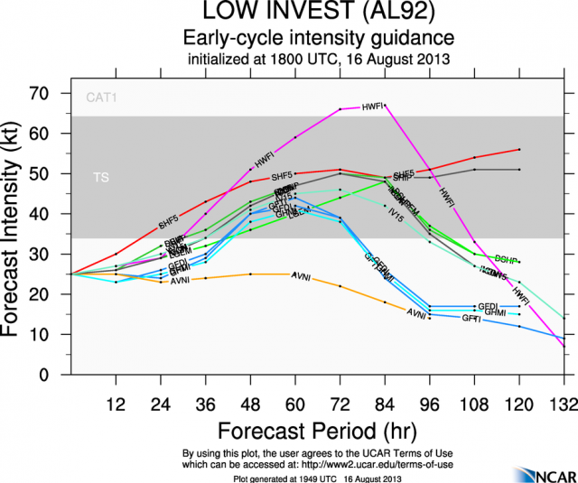
I know they are not the most reliable, but are the latest intensity models showing?
0 likes   
The posts in this forum are NOT official forecast and should not be used as such. They are just the opinion of the poster and may or may not be backed by sound meteorological data. They are NOT endorsed by any professional institution or storm2k.org. For official information, please refer to the NHC and NWS products.

ozonepete
Professional-Met
Professional-Met
Posts: 4743
Joined: Mon Sep 07, 2009 3:23 pm
Location: From Ozone Park, NYC / Now in Brooklyn, NY

Re:

#735 Postby ozonepete » Fri Aug 16, 2013 5:32 pm

HurriGuy wrote:I know they are not the most reliable, but are the latest intensity models showing?


LOL, yes, intensity forecasts still leave a lot to be desired, but here's the 18Z chart of model forecasts for intensity from NCAR at Colorado State:

Image
0 likes   

ozonepete
Professional-Met
Professional-Met
Posts: 4743
Joined: Mon Sep 07, 2009 3:23 pm
Location: From Ozone Park, NYC / Now in Brooklyn, NY

Re: ATL: INVEST 92L - Discussion

#736 Postby ozonepete » Fri Aug 16, 2013 5:38 pm

Btw, I would say 2 things here: First,this is truly one of the most complicated developing TC situations I have ever seen, and I've seen a lot - all of us here have. Second, if this develops from where I have it circled and becomes a TS and moves north to the central Gulf coast, the new and improved GFS can probably really be called improved and gets another big win over the Euro.
Last edited by ozonepete on Fri Aug 16, 2013 5:39 pm, edited 1 time in total.
0 likes   

Dean4Storms
S2K Supporter
S2K Supporter
Posts: 6358
Age: 62
Joined: Sun Aug 31, 2003 1:01 pm
Location: Miramar Bch. FL

#737 Postby Dean4Storms » Fri Aug 16, 2013 5:39 pm

18z GFS now with the northern vort heading to the Mobile, AL area showing 43kt winds at 850mb.

That is sort of a concern considering how easily this could become Tropical, we all know these models are not so great with intensity. This Vort would also cross over some of the warmest SST's in the Gulf over 30C.
0 likes   

Javlin
Category 5
Category 5
Posts: 1620
Age: 64
Joined: Fri Jul 09, 2004 7:58 pm
Location: ms gulf coast

Re: ATL: INVEST 92L - Discussion

#738 Postby Javlin » Fri Aug 16, 2013 5:49 pm

wxman57 wrote:I'd say another LLC is forming closer to 22.5N/90.6W. Squalls are streaming northward along 90W, so it's not east of there. I certainly wouldn't rule out it being picked up and taken northward. Follow the convection. Currently, the convection is streaming N-NNE.


It's a rule I usually follow for short term direction but the rule did not pan out for me the other day when SSE of the YUC strait.Have to see how mother nature wants to play this hand?
0 likes   

wjs3
S2K Supporter
S2K Supporter
Posts: 633
Joined: Sat Aug 14, 2004 7:57 am

Re: ATL: INVEST 92L - Discussion

#739 Postby wjs3 » Fri Aug 16, 2013 5:57 pm

ozonepete wrote:Btw, I would say 2 things here: First,this is truly one of the most complicated developing TC situations I have ever seen, and I've seen a lot - all of us here have. Second, if this develops from where I have it circled and becomes a TS and moves north to the central Gulf coast, the new and improved GFS can probably really be called improved and gets another big win over the Euro.


Ozonepete:

As you know I'm half a world away right now and most images in these threads don't appear behind the great firewall of China, so bear with me...

Even though I can't see the pictures, it sounds like there's some chance that this northern vort you've described has its genesis in an old cold-core upper low. Is it perhaps going to be a Subtropical Storm, not a tropical storm (at least at first), assuming something works down to the surface?

Or are models, synoptic analysis, etc. predicting more of a warm core look? It sounds like given this complex genesis, there could be some hybrid-ness, but as I said, all I have in front of me right now is what I'm reading, so set me straight, please.
0 likes   

User avatar
HouTXmetro
Category 5
Category 5
Posts: 3949
Joined: Sun Jun 13, 2004 6:00 pm
Location: District of Columbia, USA

#740 Postby HouTXmetro » Fri Aug 16, 2013 6:01 pm

Convection exploding (as usual this time of day) over the Yucatan. Let's see how this affects 92L.
0 likes   
[Disclaimer: My Amateur Opinion, please defer to your local authorities or the NHC for Guidance.]


Return to “2013”

Who is online

Users browsing this forum: No registered users and 2 guests