WPAC: HAIYAN - Post-Tropical
Moderator: S2k Moderators
-
SouthDadeFish

- Professional-Met

- Posts: 2836
- Joined: Thu Sep 23, 2010 2:54 pm
- Location: Miami, FL
- Contact:
-
cycloneye

- Admin

- Posts: 149741
- Age: 69
- Joined: Thu Oct 10, 2002 10:54 am
- Location: San Juan, Puerto Rico
Re:
Tstormwatcher wrote:Anyone have a live link to a radar of this?
http://andrew.rsmas.miami.edu/bmcnoldy/ ... 13_CEB.gif
0 likes
Visit the Caribbean-Central America Weather Thread where you can find at first post web cams,radars
and observations from Caribbean basin members Click Here
and observations from Caribbean basin members Click Here
-
tolakram
- Admin
- Posts: 20186
- Age: 62
- Joined: Sun Aug 27, 2006 8:23 pm
- Location: Florence, KY (name is Mark)
Re: WPAC: HAIYAN - Typhoon
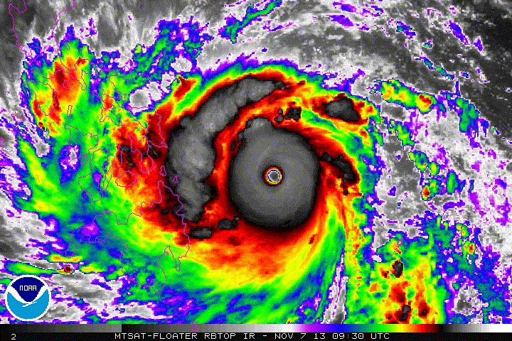
Unfortunately the cloud tops continue to cool. Just an amazing storm. One has to wonder if this is the end result of the stretch of unusually low activity we've had in the northern hemisphere.
0 likes
M a r k
- - - - -
Join us in chat: Storm2K Chatroom Invite. Android and IOS apps also available.
The posts in this forum are NOT official forecasts and should not be used as such. Posts are NOT endorsed by any professional institution or STORM2K.org. For official information and forecasts, please refer to NHC and NWS products.
-
thunderchief

- Category 1

- Posts: 306
- Joined: Tue Aug 23, 2005 11:03 pm
Re: WPAC: HAIYAN - Typhoon
I have not posted here in a long time... but this requires a post. I agree with the other mets... this is the most impressive satellite image I have ever seen. I think central pressure has to be well into the 800s, Tip itself might have competition from this storm.
0 likes
-
hurricanes1234
- Category 5

- Posts: 2908
- Joined: Sat Jul 28, 2012 6:19 pm
- Location: Trinidad and Tobago
Re: WPAC: HAIYAN - Typhoon
I cannot believe the intensity of this hyper-typhoon!!!!! 190 mph?!!! I don't even think there were twenty tropical cyclones with that wind speed or above EVER!!! And it's possible it could be a LOT stronger than this right now!!! Dare I ask what the pressure of this is, according to the official advisory, before I am BLOWN TO THE GROUND IN SHOCK?!
0 likes
PLEASE NOTE: With the exception of information from weather agencies that I may copy and paste here, my posts will NEVER be official, since I am NOT a meteorologist. They are solely my amateur opinion, and may or may not be accurate. Therefore, please DO NOT use them as official details, particularly when making important decisions. Thank you.
-
mrbagyo

- Category 5
- Posts: 3998
- Age: 33
- Joined: Thu Apr 12, 2012 9:18 am
- Location: 14.13N 120.98E
- Contact:
Re: WPAC: HAIYAN - Typhoon
Anyone have a live link to a radar of this?
I'm searching for the Guian radar... I'm sure PAGASA has all the radar image we want to see
0 likes
The posts in this forum are NOT official forecast and should not be used as such. They are just the opinion of the poster and may or may not be backed by sound meteorological data. They are NOT endorsed by any professional institution or storm2k.org. For official information, please refer to RSMC, NHC and NWS products.

Re: WPAC: HAIYAN - Typhoon
hurricanes1234 wrote:I cannot believe the intensity of this hyper-typhoon!!!!! 190 mph?!!! I don't even think there were twenty tropical cyclones with that wind speed or above EVER!!! And it's possible it could be a LOT stronger than this right now!!! Dare I ask what the pressure of this is, according to the official advisory, before I am BLOWN TO THE GROUND IN SHOCK?!
Officially its 895mb. Realistically, its probably at or below 880.
0 likes
-
euro6208
Re: WPAC: HAIYAN - Typhoon

wow...haiyan does not want to stop strengthening...white pixels continue to develop and expand in a CDO that continues to expand ...
Last edited by euro6208 on Thu Nov 07, 2013 12:47 pm, edited 1 time in total.
0 likes

-
cycloneye
- Admin
- Posts: 149741
- Age: 69
- Joined: Thu Oct 10, 2002 10:54 am
- Location: San Juan, Puerto Rico
Re: WPAC: HAIYAN - Typhoon
cycloneye wrote:cycloneye wrote:Let's see if this cam continues to work in the next few hours.
Web Cam with audio in Boracay
Another Web Cam with audio in Boracay

Bumping these cams for those members that didn't see them as they were posted this morning.Let's see when sunrise comes,how things look,if those cameras can continue to work.
0 likes
Visit the Caribbean-Central America Weather Thread where you can find at first post web cams,radars
and observations from Caribbean basin members Click Here
and observations from Caribbean basin members Click Here
-
SouthDadeFish
- Professional-Met
- Posts: 2836
- Joined: Thu Sep 23, 2010 2:54 pm
- Location: Miami, FL
- Contact:

-
hurricaneCW
- Category 5
- Posts: 1799
- Joined: Wed Mar 03, 2010 6:20 am
- Location: Toms River, NJ
Re: WPAC: HAIYAN - Typhoon
Could this be the strongest storm ever recorded? Even beating Tip. It looks unbelievable and god bless those in its path.
0 likes

Re: WPAC: HAIYAN - Typhoon
euro6208 wrote:
wow...haiyan does not want to stop strengthening...white pixels continue to develop and expand in a CDO that continues to expand ...
Just keeps on strengthening frame after frame. I wonder how magnificent it would look on visible now.
0 likes
Re: WPAC: HAIYAN - Typhoon
hurricaneCW wrote:Could this be the strongest storm ever recorded? Even beating Tip. It looks unbelievable and god bless those in its path.
Its a competitor along side Monica, Gay, and Angela. If I was a betting man, I'd wager 875 to 880.
0 likes
-
Aric Dunn
- Category 5
- Posts: 21238
- Age: 43
- Joined: Sun Sep 19, 2004 9:58 pm
- Location: Ready for the Chase.
- Contact:
Looks Like it may have actually intensified over the last couple hours..
0 likes
Note: If I make a post that is brief. Please refer back to previous posts for the analysis or reasoning. I do not re-write/qoute what my initial post said each time.
If there is nothing before... then just ask
Space & Atmospheric Physicist, Embry-Riddle Aeronautical University,
I believe the sky is falling...
If there is nothing before... then just ask
Space & Atmospheric Physicist, Embry-Riddle Aeronautical University,
I believe the sky is falling...
-
euro6208
Re: WPAC: HAIYAN - Typhoon
hurricaneCW wrote:Could this be the strongest storm ever recorded? Even beating Tip. It looks unbelievable and god bless those in its path.
this is way stronger than TIP possibly the world's strongest...
only thing missing is recon to confirm this and but guaranteed the world's strongest...
Last edited by euro6208 on Thu Nov 07, 2013 12:53 pm, edited 1 time in total.
0 likes

Re: WPAC: HAIYAN - Typhoon
This just unreal! Those poor people in the path of this extreme buzzsaw monsture.
0 likes
The following post is NOT an official forecast and should not be used as such. It is just the opinion of the poster and may or may not be backed by sound meteorological data. It is NOT endorsed by any professional institution including storm2k.org For Official Information please refer to the NHC and NWS products.
-
xtyphooncyclonex

- Category 5
- Posts: 3900
- Age: 24
- Joined: Sat Dec 08, 2012 9:07 am
- Location: Cebu City
- Contact:
Re: Re:
cebuboy wrote:xtyphooncyclonex wrote:Looks way better than STS Bopha before it was upgraded. I think (hope not real) that this will be a lot stronger than Bopha/Pablo - around 155 kts and 910 hPa.
===============
Personal Forecast Disclaimer:
The posts in this forum are NOT official forecast and should not be used as such. They are just the opinion of the poster and may or may not be backed by sound meteorological data. They are NOT endorsed by any professional institution or storm2k.org. For official information, please refer to the NHC and NWS products.
Its highly possible.. since it still have more time to spend in the ocean and could rapidly intensity further as it nears the Philippines.
My expectations were too weak! Now Haiyan is 165 kts and 895 hPa.
0 likes
REMINDER: My opinions that I, or any other NON Pro-Met in this forum, are unofficial. Please do not take my opinions as an official forecast and warning. I am NOT a meteorologist. Following my forecasts blindly may lead to false alarm, danger and risk if official forecasts from agencies are ignored.
-
hurricaneCW
- Category 5
- Posts: 1799
- Joined: Wed Mar 03, 2010 6:20 am
- Location: Toms River, NJ
Re: WPAC: HAIYAN - Typhoon
euro6208 wrote:hurricaneCW wrote:Could this be the strongest storm ever recorded? Even beating Tip. It looks unbelievable and god bless those in its path.
this is way stronger than TIP possibly the world's strongest...
only thing missing is recon to confirm this but guaranteed a record breaking storm...
I agree, the T#s over 8.0 which is like the top limit are a huge indication of that. This could really be 180 kts sustained.
0 likes
-
Tstormwatcher

- S2K Supporter

- Posts: 3086
- Joined: Thu Oct 20, 2005 7:31 pm
- Location: New Bern, NC
Re: Re:
cycloneye wrote:Tstormwatcher wrote:Anyone have a live link to a radar of this?
http://andrew.rsmas.miami.edu/bmcnoldy/ ... 13_CEB.gif
Thank you.
0 likes
Who is online
Users browsing this forum: No registered users and 30 guests