WPAC: HAIYAN - Post-Tropical

Moderator: S2k Moderators

Message
Author
euro6208

Re: WPAC: HAIYAN - Typhoon

#501 Postby euro6208 » Thu Nov 07, 2013 8:37 am

Image

https://twitter.com/extremestorms

sad photo showing over 100 families packing a church located just 0.2 miles from the shoreline...this is looking like the storm of the century! :(
0 likes   

fogbreath
Tropical Depression
Tropical Depression
Posts: 50
Joined: Fri Oct 30, 2009 11:07 am
Location: Central Ohio via San Fran via Northern FL

#502 Postby fogbreath » Thu Nov 07, 2013 8:41 am

I'm relieved my parents' provinces aren't directly in the path of the storm, but very worried for those who will be. My best goes out to all of you
0 likes   

CrazyC83
Professional-Met
Professional-Met
Posts: 34002
Joined: Tue Mar 07, 2006 11:57 pm
Location: Deep South, for the first time!

Re: WPAC: HAIYAN - Typhoon

#503 Postby CrazyC83 » Thu Nov 07, 2013 8:42 am

euro6208 wrote:Image

https://twitter.com/extremestorms

sad photo showing over 100 families packing a church located just 0.2 miles from the shoreline...this is looking like the storm of the century! :(


With all those windows, I doubt that could withstand even a Category 1 easily - forget a Category 5+...
0 likes   

CrazyC83
Professional-Met
Professional-Met
Posts: 34002
Joined: Tue Mar 07, 2006 11:57 pm
Location: Deep South, for the first time!

Re: WPAC: HAIYAN - Typhoon

#504 Postby CrazyC83 » Thu Nov 07, 2013 8:45 am

This might be old, but downright scary:

07/0857 UTC 9.9N 130.0E T8.0/8.0 HAIYAN -- West Pacific
0 likes   

oaba09
S2K Supporter
S2K Supporter
Posts: 1496
Age: 38
Joined: Thu Oct 01, 2009 10:02 am
Location: Valenzuela, Philippines
Contact:

Re: WPAC: HAIYAN - Typhoon

#505 Postby oaba09 » Thu Nov 07, 2013 8:49 am

CrazyC83 wrote:
euro6208 wrote:Image

https://twitter.com/extremestorms

sad photo showing over 100 families packing a church located just 0.2 miles from the shoreline...this is looking like the storm of the century! :(


With all those windows, I doubt that could withstand even a Category 1 easily - forget a Category 5+...

Yeah...those things were made as design pieces...they were not made to withstand typhoons!
0 likes   

tolakram
Admin
Admin
Posts: 20009
Age: 62
Joined: Sun Aug 27, 2006 8:23 pm
Location: Florence, KY (name is Mark)

Re: WPAC: HAIYAN - Typhoon

#506 Postby tolakram » Thu Nov 07, 2013 8:49 am

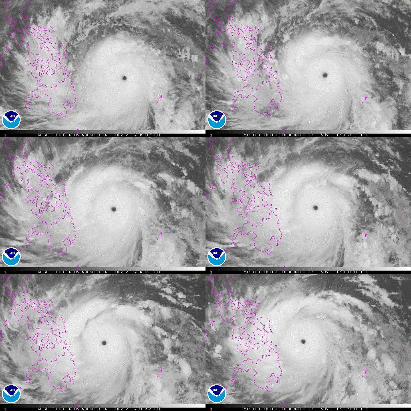
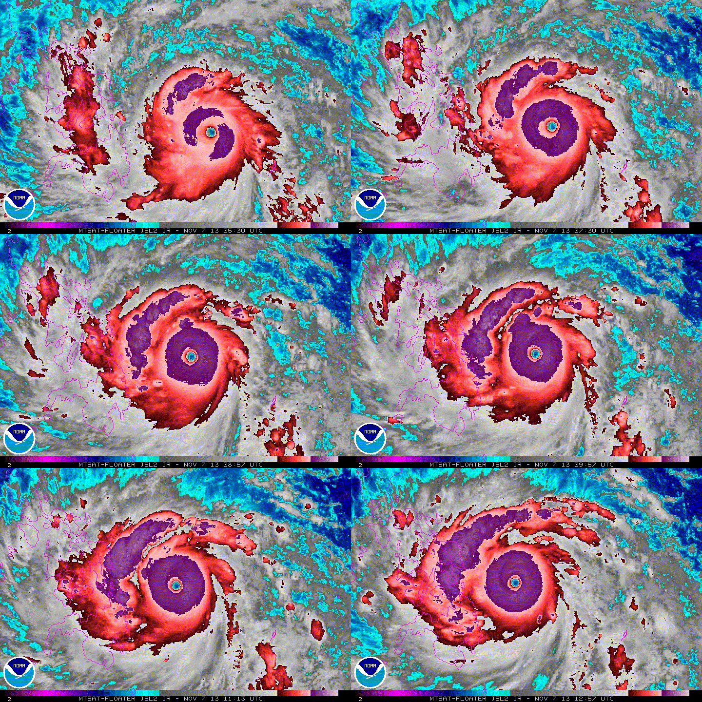
One scary looking storm.

saved loops

Image

Looks to be strengthening as well. Hopefully people in the path can somehow stay safe and find shelter.

Image
1 likes   
M a r k
- - - - -
Join us in chat: Storm2K Chatroom Invite. Android and IOS apps also available.

The posts in this forum are NOT official forecasts and should not be used as such. Posts are NOT endorsed by any professional institution or STORM2K.org. For official information and forecasts, please refer to NHC and NWS products.

User avatar
somethingfunny
ChatStaff
ChatStaff
Posts: 3926
Age: 37
Joined: Thu May 31, 2007 10:30 pm
Location: McKinney, Texas

Re: WPAC: HAIYAN - Typhoon

#507 Postby somethingfunny » Thu Nov 07, 2013 8:52 am

stormstrike wrote:
somethingfunny wrote:
stormstrike wrote:I take back what I've said in my previous post..It is not a bright side experiencing this first hand.. :crying:

It's eerily calm here right now in our area. It's like there's no supertyphoon coming.

Oh God please spare us from great danger. :(


Where are you located?


Tacloban City, Leyte :eek:


:eek:

How far above sea level are you? What construction is your house and do you plan to stay in it? Do you have supplies ready for what could be at least a week after the storm without any utilities or transportation?

Please be safe. Please update us when you can but prioritize your safety and your family's safety above anything else.
0 likes   
I am not a meteorologist, and any posts made by me are not official forecasts or to be interpreted as being intelligent. These posts are just my opinions and are probably silly opinions.

hurricaneCW
Category 5
Category 5
Posts: 1794
Joined: Wed Mar 03, 2010 6:20 am
Location: Toms River, NJ

Re: WPAC: HAIYAN - Typhoon

#508 Postby hurricaneCW » Thu Nov 07, 2013 8:53 am

How many people are in the path of this monster?
0 likes   

User avatar
wxman57
Moderator-Pro Met
Moderator-Pro Met
Posts: 22978
Age: 67
Joined: Sat Jun 21, 2003 8:06 pm
Location: Houston, TX (southwest)

Re: WPAC: HAIYAN - Typhoon

#509 Postby wxman57 » Thu Nov 07, 2013 8:55 am

stormstrike wrote:
Tacloban City, Leyte :eek:


Based upon your stated location and the wind radii we're estimating in Haiyan, I calculated a wind profile that has you possibly seeing winds of 140-170 mph with gusts of 200 mph around 0200UTC tomorrow. It shows a 15+ hour duration of TS winds and about 5 1/2 hrs of potential typhoon conditions starting at 2300 UTC today. Note that these are the max winds projected, not the average winds. Tried to upload the graphic but my web server is down.
0 likes   

Alyono
Professional-Met
Professional-Met
Posts: 6961
Joined: Fri Apr 26, 2013 3:52 pm
Location: Texas Coast

#510 Postby Alyono » Thu Nov 07, 2013 8:55 am

Due tot he ridging north of the system, I am fairly certain the pressure is quite a ways above that of Tip. The Atlantic P/W may be more appropriate here.

Reember, recon found 175 KT at the surface in Megi and the pressure was 890mb
0 likes   

Alyono
Professional-Met
Professional-Met
Posts: 6961
Joined: Fri Apr 26, 2013 3:52 pm
Location: Texas Coast

Re: WPAC: HAIYAN - Typhoon

#511 Postby Alyono » Thu Nov 07, 2013 8:56 am

euro6208 wrote:https://pbs.twimg.com/media/BYd56iLCUAA4tsv.jpg

https://twitter.com/extremestorms

sad photo showing over 100 families packing a church located just 0.2 miles from the shoreline...this is looking like the storm of the century! :(


whoever made that evacuation decision should face murder charges after the storm
0 likes   

User avatar
xtyphooncyclonex
Category 5
Category 5
Posts: 3861
Age: 23
Joined: Sat Dec 08, 2012 9:07 am
Location: Cebu City
Contact:

Re: WPAC: HAIYAN - Typhoon

#512 Postby xtyphooncyclonex » Thu Nov 07, 2013 8:57 am

wxman57 wrote:
stormstrike wrote:
Tacloban City, Leyte :eek:


Based upon your stated location and the wind radii we're estimating in Haiyan, I calculated a wind profile that has you possibly seeing winds of 140-170 mph with gusts of 200 mph around 0200UTC tomorrow. It shows a 15+ hour duration of TS winds and about 5 1/2 hrs of potential typhoon conditions starting at 2300 UTC today. Note that these are the max winds projected, not the average winds. Tried to upload the graphic but my web server is down.

How about Cebu City?
0 likes   
REMINDER: My opinions that I, or any other NON Pro-Met in this forum, are unofficial. Please do not take my opinions as an official forecast and warning. I am NOT a meteorologist. Following my forecasts blindly may lead to false alarm, danger and risk if official forecasts from agencies are ignored.

Alyono
Professional-Met
Professional-Met
Posts: 6961
Joined: Fri Apr 26, 2013 3:52 pm
Location: Texas Coast

#513 Postby Alyono » Thu Nov 07, 2013 8:58 am

0 likes   

CrazyC83
Professional-Met
Professional-Met
Posts: 34002
Joined: Tue Mar 07, 2006 11:57 pm
Location: Deep South, for the first time!

Re: WPAC: HAIYAN - Typhoon

#514 Postby CrazyC83 » Thu Nov 07, 2013 9:00 am

hurricaneCW wrote:How many people are in the path of this monster?


Eastern Visayas (ground zero) has about 4.5 million people.

However, in all the regions in the track, I can see about 50 million people potentially at risk.
0 likes   

stormstrike
Tropical Storm
Tropical Storm
Posts: 159
Joined: Thu Nov 29, 2012 12:37 am

Re: WPAC: HAIYAN - Typhoon

#515 Postby stormstrike » Thu Nov 07, 2013 9:01 am

somethingfunny wrote:
stormstrike wrote:
somethingfunny wrote:
Where are you located?


Tacloban City, Leyte :eek:


:eek:

How far above sea level are you? What construction is your house and do you plan to stay in it? Do you have supplies ready for what could be at least a week after the storm without any utilities or transportation?

Please be safe. Please update us when you can but prioritize your safety and your family's safety above anything else.


We're not evacuating. Our house is sturdy. I hope. :(

We have food supplies. Trimmed our trees. And boarded up our windows. Anyway this is the first time that I've seen houses boarded up with plywood in our neighborhood. :eek:

By the time I'm writing this. We are already experiencing tropical storm winds plus heavy rains!

Any minute now the electricity will be down. Let's all be safe guys out there especially my fellow countrymen! :double:
0 likes   

User avatar
wxman57
Moderator-Pro Met
Moderator-Pro Met
Posts: 22978
Age: 67
Joined: Sat Jun 21, 2003 8:06 pm
Location: Houston, TX (southwest)

Re: WPAC: HAIYAN - Typhoon

#516 Postby wxman57 » Thu Nov 07, 2013 9:02 am

xtyphooncyclonex wrote:
wxman57 wrote:
stormstrike wrote:
Tacloban City, Leyte :eek:


Based upon your stated location and the wind radii we're estimating in Haiyan, I calculated a wind profile that has you possibly seeing winds of 140-170 mph with gusts of 200 mph around 0200UTC tomorrow. It shows a 15+ hour duration of TS winds and about 5 1/2 hrs of potential typhoon conditions starting at 2300 UTC today. Note that these are the max winds projected, not the average winds. Tried to upload the graphic but my web server is down.

How about Cebu City?


Ran one for you, too. Shows peak winds 50-75 mph there. Generally strong TS with the possibility of a brief period of 1-min wind to 75 mph. Of course, this is based on a satellite estimate of wind radii.
0 likes   

User avatar
cycloneye
Admin
Admin
Posts: 145308
Age: 68
Joined: Thu Oct 10, 2002 10:54 am
Location: San Juan, Puerto Rico

Re: WPAC: HAIYAN - Typhoon

#517 Postby cycloneye » Thu Nov 07, 2013 9:03 am

MSGID/GENADMIN/JOINT TYPHOON WRNCEN PEARL HARBOR HI//
SUBJ/ TROPICAL CYCLONE WARNING//
RMKS/
1. SUPER TYPHOON 31W (HAIYAN) WARNING NR 018
01 ACTIVE TROPICAL CYCLONE IN NORTHWESTPAC
MAX SUSTAINED WINDS BASED ON ONE-MINUTE AVERAGE
WIND RADII VALID OVER OPEN WATER ONLY
---
WARNING POSITION:
071200Z --- NEAR 10.2N 129.1E
MOVEMENT PAST SIX HOURS - 295 DEGREES AT 22 KTS
POSITION ACCURATE TO WITHIN 025 NM
POSITION BASED ON EYE FIXED BY SATELLITE
PRESENT WIND DISTRIBUTION:
MAX SUSTAINED WINDS - 165 KT, GUSTS 200 KT
WIND RADII VALID OVER OPEN WATER ONLY

Image
0 likes   
Visit the Caribbean-Central America Weather Thread where you can find at first post web cams,radars
and observations from Caribbean basin members Click Here

Alyono
Professional-Met
Professional-Met
Posts: 6961
Joined: Fri Apr 26, 2013 3:52 pm
Location: Texas Coast

Re: WPAC: HAIYAN - Typhoon

#518 Postby Alyono » Thu Nov 07, 2013 9:05 am

stormstrike wrote:
We're not evacuating. Our house is sturdy. I hope. :(

We have food supplies. Trimmed our trees. And boarded up our windows. Anyway this is the first time that I've seen houses boarded up with plywood in our neighborhood. :eek:

By the time I'm writing this. We are already experiencing tropical storm winds plus heavy rains!

Any minute now the electricity will be down. Let's all be safe guys out there especially my fellow countrymen! :double:


To put the expected winds in perspective.. remember the Moore tornado? That is the wind you will see. Can your house withstand that?
0 likes   

CrazyC83
Professional-Met
Professional-Met
Posts: 34002
Joined: Tue Mar 07, 2006 11:57 pm
Location: Deep South, for the first time!

#519 Postby CrazyC83 » Thu Nov 07, 2013 9:06 am

If the track stays inside the Leyte Gulf, this could be a storm surge event for the ages there, especially in Tablocan City. Much of the developed area is at fairly low elevation.
0 likes   

hurricaneCW
Category 5
Category 5
Posts: 1794
Joined: Wed Mar 03, 2010 6:20 am
Location: Toms River, NJ

Re: WPAC: HAIYAN - Typhoon

#520 Postby hurricaneCW » Thu Nov 07, 2013 9:07 am

CrazyC83 wrote:
hurricaneCW wrote:How many people are in the path of this monster?


Eastern Visayas (ground zero) has about 4.5 million people.

However, in all the regions in the track, I can see about 50 million people potentially at risk.


Wow and they've already had flooding rains and an earthquake to deal with. I imagine this could weaken some before it landfalls as most storms usually do to some extent as it's hard to believe Haiyan will sustain this strength, but it'll probably still be a STY when it impacts those areas.
0 likes   


Return to “2013”

Who is online

Users browsing this forum: No registered users and 2 guests