
Anti-cyclone has now moved to the west of the LLC.
It will now be tracking into the anti-cyclone allowing its vorticity column to expand vertically and spin up.
It appears to has a large stretch ahead of increasing tropopause height which will give it a good chance to strengthen into a TD and possible TS.
ATL: DORIAN - Post-Tropical - Discussion
Moderator: S2k Moderators
Re: ATL: INVEST 98L - Discussion
0 likes
-
wxman57

- Moderator-Pro Met

- Posts: 23175
- Age: 68
- Joined: Sat Jun 21, 2003 8:06 pm
- Location: Houston, TX (southwest)
Re: ATL: INVEST 98L - Discussion
Senobia wrote:
Does it happen often that a system that newly off Africa has such high chances of development? Haven't paid attention to the models and such until this year so I don't have anything to compare it to.
On a side note, Eric Berger (Science Blogger, not a pro-met, from a Houston newspaper) gives a conflicting outlook on 98L: (I don't know how to link text: http://www.beaumontenterprise.com/news/ ... 681823.php)
First he's very, "Meh - don't worry about it. It won't make it into the Gulf" and then likens it to two of the worst storms Texas has ever seen.
If a system has a well-defined LLC then it's not uncommon for it to be given a high chance of development. NHC is the organization that both estimates chances of development AND decides if it has developed, so when they go higher with the percent chance of development it means they're considering naming it.
I red Eric Berger's blog entry and in no way does he liken 98L to Ike or the 1900 Galveston hurricane. He simply says that development of 98L would be a signal that the Cape Verde season is beginning.
0 likes
-
cycloneye

- Admin

- Posts: 149683
- Age: 69
- Joined: Thu Oct 10, 2002 10:54 am
- Location: San Juan, Puerto Rico
Re: ATL: INVEST 98L - Discussion
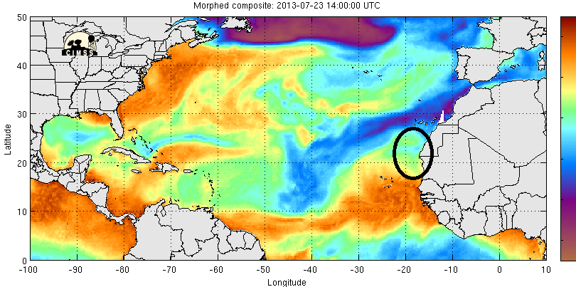
Last visible image of this day.

0 likes
Visit the Caribbean-Central America Weather Thread where you can find at first post web cams,radars
and observations from Caribbean basin members Click Here
and observations from Caribbean basin members Click Here
-
cycloneye
- Admin
- Posts: 149683
- Age: 69
- Joined: Thu Oct 10, 2002 10:54 am
- Location: San Juan, Puerto Rico
Re: ATL: INVEST 98L - Models
Very interesting that LGEM makes it a hurricane.

0 likes
Visit the Caribbean-Central America Weather Thread where you can find at first post web cams,radars
and observations from Caribbean basin members Click Here
and observations from Caribbean basin members Click Here
-
cycloneye
- Admin
- Posts: 149683
- Age: 69
- Joined: Thu Oct 10, 2002 10:54 am
- Location: San Juan, Puerto Rico
Re: ATL: INVEST 98L - Discussion

0 likes
Visit the Caribbean-Central America Weather Thread where you can find at first post web cams,radars
and observations from Caribbean basin members Click Here
and observations from Caribbean basin members Click Here

ATL: INVEST 98L - Models
Beginner question here. Does a higher intensity storm tend to recurve north and out to sea? Does a lower intensity storm tend to continue west?
If at 48 hrs this begins to taper off like the intensity forecast shows, would that allow the remnants to continue west towards the leewards and have a chance to reform if the conditions are favorable?
Thanks!
If at 48 hrs this begins to taper off like the intensity forecast shows, would that allow the remnants to continue west towards the leewards and have a chance to reform if the conditions are favorable?
Thanks!
0 likes
Re: ATL: INVEST 98L - Models
andrewp23 wrote:Beginner question here. Does a higher intensity storm tend to recurve north and out to sea? Does a lower intensity storm tend to continue west?
If at 48 hrs this begins to taper off like the intensity forecast shows, would that allow the remnants to continue west towards the leewards and have a chance to reform if the conditions are favorable?
Thanks!
A stronger storm tends to get steered by a different level of the atmosphere then a weaker one. You can see the steering winds here.
http://tropic.ssec.wisc.edu/real-time/d ... oom=&time=
To be honest. The ridge is so strong over the North Central Atlantic, that this thing is not going to recruve east of Bermuda no matter how strong it gets IMO.
0 likes


-
Blown Away

- S2K Supporter

- Posts: 10253
- Joined: Wed May 26, 2004 6:17 am
Re: ATL: INVEST 98L - Models
Doesn't the NHC rely somewhat on the LGEM for intensity predictions?? SHIP/DSHP up to Cane, so that should reflect in the next update??
0 likes
Hurricane Eye Experience: David 79, Irene 99, Frances 04, Jeanne 04, Wilma 05… Hurricane Brush Experience: Andrew 92, Erin 95, Floyd 99, Matthew 16, Irma 17, Ian 22, Nicole 22…

Re: ATL: INVEST 98L - Discussion
wxman57 wrote:
I red Eric Berger's blog entry and in no way does he liken 98L to Ike or the 1900 Galveston hurricane. He simply says that development of 98L would be a signal that the Cape Verde season is beginning.
Thank you for your answer about the development percentages. But what I was asking is - it's at 60% already. And it's not very far off the coast of Africa. Does this happen often and is it a precursor to a bigger/stronger storm, because it was so well-defined from the beginning?
In reference to Berger's blog, this is what he followed the initial statement that you referenced with:
Storms that form in this region and track westward across the Atlantic Ocean are often the most powerful and dangerous storms that form in a given hurricane season. The two most destructive hurricanes to have hit the upper Texas coast, Hurricane Ike in 2008 and the Great Storm of 1900, were both Cape Verde hurricanes.
And then he backs off again:
This is not to say one should panic. Invest 98L probably won't have a significant effect on the United States.
Last edited by Senobia on Tue Jul 23, 2013 3:49 pm, edited 2 times in total.
0 likes


-
TropicalAnalystwx13

- Category 5

- Posts: 2109
- Age: 28
- Joined: Tue Jul 19, 2011 8:20 pm
- Location: Wilmington, NC
- Contact:
-
floridasun78
- Category 5
- Posts: 3755
- Joined: Sun May 17, 2009 10:16 pm
- Location: miami fl
Re: ATL: INVEST 98L - Models
Blown Away wrote:
Doesn't the NHC rely somewhat on the LGEM for intensity predictions?? SHIP/DSHP up to Cane, so that should reflect in the next update??
i think their do nhc use ship in their forecast of system
0 likes

Re:
artist wrote:http://moe.met.fsu.edu/cgi-bin/ecmwf-opertc2.cgi?time=2013072312&field=850mb+Vorticity&hour=Animation
ECMWF animation
Looking at that animation it would need to move NW now and keeping moving that way for that run to verify.
0 likes
The following post is NOT an official forecast and should not be used as such. It is just the opinion of the poster and may or may not be backed by sound meteorological data. It is NOT endorsed by any professional institution including storm2k.org For Official Information please refer to the NHC and NWS products.

Who is online
Users browsing this forum: No registered users and 120 guests