ATL: CHANTAL - Post-Tropical

Moderator: S2k Moderators

Message
Author
User avatar
Gustywind
Category 5
Category 5
Posts: 12334
Joined: Mon Sep 03, 2007 7:29 am
Location: Baie-Mahault, GUADELOUPE

#161 Postby Gustywind » Sat Jul 06, 2013 8:39 pm

Tracking Info For Invest 95L

:rarrow: http://www.wunderground.com/tropical/at ... track.html


18 GMT 07/6/13 8.0N 34.8W 25 1009 Invest
00 GMT 07/7/13 8.2N 36.4W 25 1009 Invest
0 likes   

User avatar
SFLcane
S2K Supporter
S2K Supporter
Posts: 10163
Age: 47
Joined: Sat Jun 05, 2010 1:44 pm
Location: Lake Worth Florida

Re: Threes Company

#162 Postby SFLcane » Sat Jul 06, 2013 8:45 pm

Cyclenall wrote:
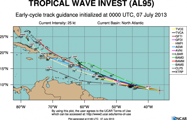
Gustywind wrote:0z Models guidance

3rd time the charm? Still no intensity forecast on it.

EDIT: I got an strange error that said, "The requested post does not exist" ... never seen that one before. The 3rd repeat is now also removed.


Image
0 likes   

User avatar
blp
Category 5
Category 5
Posts: 2840
Age: 46
Joined: Thu Sep 09, 2004 7:51 pm
Location: Miami, FL
Contact:

Re: ATL: INVEST 95L - Discussion

#163 Postby blp » Sat Jul 06, 2013 8:45 pm

850mb vorticity much improved than 3hrs ago.

3hrs ago:
Image

Current:
Image
0 likes   
The following post is NOT an official forecast and should not be used as such. It is just the opinion of the poster and may or may not be backed by sound meteorological data. It is NOT endorsed by any professional institution including storm2k.org For Official Information please refer to the NHC and NWS products.

User avatar
cycloneye
Admin
Admin
Posts: 145295
Age: 68
Joined: Thu Oct 10, 2002 10:54 am
Location: San Juan, Puerto Rico

Re: ATL: INVEST 95L - Discussion

#164 Postby cycloneye » Sat Jul 06, 2013 9:23 pm

Low level convergence is much more tight now than in the past 6-12 hours.

Image
0 likes   
Visit the Caribbean-Central America Weather Thread where you can find at first post web cams,radars
and observations from Caribbean basin members Click Here

User avatar
bvigal
S2K Supporter
S2K Supporter
Posts: 2276
Joined: Sun Jul 24, 2005 8:49 am
Location: British Virgin Islands
Contact:

Re: ATL: INVEST 95L - Discussion

#165 Postby bvigal » Sat Jul 06, 2013 9:27 pm

I think this looks healthy, and I thought so yesterday, too. I know about the SAL, but it didn't look like that big a factor. It may be sucking in a tiny bit now, but doubt it's enough to kill it completely. The SAL product doesn't show the height. If you live in the islands, you've seen days when the SAL looked like you'd be choking in haze and you look out at a sharp horizon - the SAL is high up. I always look at the water vapor, too. Sometimes you see moisture there that is in exact same spot as some of the SAL. Also, I've seen lows pull enough moisture up from equator and just chug right through what we see on SAL product. Other factors besides SAL: NO shear (the biggest positive factor) unbelievable 0-10kt until this afternoon when near that area of up to 20kt just to the north, and no shear past there all the way to EC islands; vorticity showing on surface now through 500mb, increasing convergence, divergence, good shape for over 24hrs, convection fairly consistant. Really, what else do we need to say this a healthy wave and will likely not go "poof"?
0 likes   

Alyono
Professional-Met
Professional-Met
Posts: 6961
Joined: Fri Apr 26, 2013 3:52 pm
Location: Texas Coast

#166 Postby Alyono » Sat Jul 06, 2013 9:33 pm

I have no idea as to why NHC says environmental conditions will be more favorable in a few days. All indications from the models are for a significant increase in shear as this approaches the islands.

As for its current state, easterly wind shear is taking its toll on this this evening. The center is well east of the convection. Still a 50 percent chance of development through the next 48, but if it doesnt develop within that time period, it likely wont develop it at all
0 likes   

User avatar
TropicalAnalystwx13
Category 5
Category 5
Posts: 2109
Age: 27
Joined: Tue Jul 19, 2011 8:20 pm
Location: Wilmington, NC
Contact:

Re:

#167 Postby TropicalAnalystwx13 » Sat Jul 06, 2013 9:37 pm

Alyono wrote:I have no idea as to why NHC says environmental conditions will be more favorable in a few days. All indications from the models are for a significant increase in shear as this approaches the islands.

As for its current state, easterly wind shear is taking its toll on this this evening. The center is well east of the convection. Still a 50 percent chance of development through the next 48, but if it doesnt develop within that time period, it likely wont develop it at all

There's always a chance it develops in the Bahamas region, northwestern Caribbean, or eastern Gulf of Mexico in about a week. Flow on the southwest side of a high is always slower which helps air pile (you already know this). The CMC indicates a tropical storm, and the GFS, while not enthusiastic at all, does show an area of low pressure southeast of Louisiana in roughly the same time.
0 likes   

User avatar
bvigal
S2K Supporter
S2K Supporter
Posts: 2276
Joined: Sun Jul 24, 2005 8:49 am
Location: British Virgin Islands
Contact:

Re: ATL: INVEST 95L - Discussion

#168 Postby bvigal » Sat Jul 06, 2013 9:38 pm

Well my account with the picture storage is inactive so I can't store a pic of the shear, but at http://tropic.ssec.wisc.edu/real-time/a ... wg8sht.GIF this system is in blue, which the key says is 0 to 10kt of shear. I guess I've been reading that map wrong all these years, ;-)
0 likes   

User avatar
blp
Category 5
Category 5
Posts: 2840
Age: 46
Joined: Thu Sep 09, 2004 7:51 pm
Location: Miami, FL
Contact:

Re: ATL: INVEST 95L - Discussion

#169 Postby blp » Sat Jul 06, 2013 9:43 pm

Here is another view. It is almost there and elongated.

Image
0 likes   
The following post is NOT an official forecast and should not be used as such. It is just the opinion of the poster and may or may not be backed by sound meteorological data. It is NOT endorsed by any professional institution including storm2k.org For Official Information please refer to the NHC and NWS products.

User avatar
gatorcane
S2K Supporter
S2K Supporter
Posts: 23691
Age: 47
Joined: Sun Mar 13, 2005 3:54 pm
Location: Boca Raton, FL

Re:

#170 Postby gatorcane » Sat Jul 06, 2013 10:29 pm

Alyono wrote:I have no idea as to why NHC says environmental conditions will be more favorable in a few days. All indications from the models are for a significant increase in shear as this approaches the islands.

As for its current state, easterly wind shear is taking its toll on this this evening. The center is well east of the convection. Still a 50 percent chance of development through the next 48, but if it doesnt develop within that time period, it likely wont develop it at all


I don't see the shear models are seeing and that some other folks have mentioned. There is a ULL passing north of Hispaniola that is moving briskly west underneath the steering of a powerful Bermuda High ridge to the north. Once that clears out, I don't see any shear in the vicinity of the islands at all. What weather system is going to cause all this shear?

But i don't think it will matter anyway, SAL is already getting to this little system along with some easterly shear now as you mention and I think it's on it's way on out. Will likely not be nearly as impressive looking by tomorrow with much less convection. Likely the NHC will need to downgrade development chances over the next day or so.
0 likes   

ozonepete
Professional-Met
Professional-Met
Posts: 4743
Joined: Mon Sep 07, 2009 3:23 pm
Location: From Ozone Park, NYC / Now in Brooklyn, NY

Re:

#171 Postby ozonepete » Sat Jul 06, 2013 10:48 pm

Aric Dunn wrote:SAL doesn't always mean no development. It is situated in a nice pocket of moist air in the mid and upper levels. the SAL is lagging behind the system and to the north. so far considering all that have mentioned sal being around it have not noticed despite it the convection has not only maintained but increased this afternoon.

http://tropic.ssec.wisc.edu/real-time/m ... t72hrs.gif


Thanks for saying that. SAL is often way over-rated as a limiting factor. I've seen many systems with heavy SAL just to the north that never ingested any of it, or even more interesting, ingested some of it and developed anyway. There is a lot more research that needs to be done on the influence of the SAL, especially because very moist air can hold a lot of dust but it's still very moist, which is all that counts. The precipitable water flow is a much better measure. And looking at this system it's really hard to see how it's choking on dust when there's so much convection going on.
Last edited by ozonepete on Sat Jul 06, 2013 10:49 pm, edited 1 time in total.
0 likes   

floridasun78
Category 5
Category 5
Posts: 3755
Joined: Sun May 17, 2009 10:16 pm
Location: miami fl

Re: ATL: INVEST 95L - Discussion

#172 Postby floridasun78 » Sat Jul 06, 2013 10:49 pm

i see all storm are to west of circulation
0 likes   

User avatar
NDG
S2K Supporter
S2K Supporter
Posts: 15446
Joined: Sun Jul 09, 2006 10:14 pm
Location: Orlando, FL

Re: ATL: INVEST 95L - Discussion

#173 Postby NDG » Sat Jul 06, 2013 10:53 pm

Just by the looks of its satellite presentation, easterly shear seems to be more of the problem in all levels of the atmosphere thus why it may have a problem closing a circulation off at the surface.
Tonight's 0z GFS model has it approaching Barbados Monday night, that is a fast track westward!
0 likes   

CrazyC83
Professional-Met
Professional-Met
Posts: 34002
Joined: Tue Mar 07, 2006 11:57 pm
Location: Deep South, for the first time!

Re: ATL: INVEST 95L - Discussion

#174 Postby CrazyC83 » Sat Jul 06, 2013 11:06 pm

NDG wrote:Just by the looks of its satellite presentation, easterly shear seems to be more of the problem in all levels of the atmosphere thus why it may have a problem closing a circulation off at the surface.
Tonight's 0z GFS model has it approaching Barbados Monday night, that is a fast track westward!


Sometimes they can still manage to thrive especially with an anticyclone above, but it tends to be hit and miss. Charley in 2004 was a good example.
0 likes   

CrazyC83
Professional-Met
Professional-Met
Posts: 34002
Joined: Tue Mar 07, 2006 11:57 pm
Location: Deep South, for the first time!

Re: ATL: INVEST 95L - Models

#175 Postby CrazyC83 » Sat Jul 06, 2013 11:09 pm

blp wrote:Updated:

Image


That seems quite reasonable given the trough pattern. I see any north turn being near 80W.
0 likes   

User avatar
meriland23
Category 5
Category 5
Posts: 1239
Age: 37
Joined: Mon Aug 29, 2011 9:29 pm

#176 Postby meriland23 » Sat Jul 06, 2013 11:12 pm

Howy people! Coming back to storm2k this season, looking at this new invest. So what are your guyses 'opinions' on what is going on/ will happen.. IYO
0 likes   
The posts in this forum are NOT official forecast and should not be used as such. They are just the opinion of the poster and may or may not be backed by sound meteorological data. They are NOT endorsed by any professional institution or storm2k.org. For official information, please refer to the NHC and NWS products.

User avatar
meriland23
Category 5
Category 5
Posts: 1239
Age: 37
Joined: Mon Aug 29, 2011 9:29 pm

Re: ATL: INVEST 95L - Models

#177 Postby meriland23 » Sat Jul 06, 2013 11:20 pm

CrazyC83 wrote:
blp wrote:Updated:

Image


That seems quite reasonable given the trough pattern. I see any north turn being near 80W.


If that does not make a turn by 75 w .. that could spell trouble. Hard to determine the intensity given the shear forecast.
0 likes   
The posts in this forum are NOT official forecast and should not be used as such. They are just the opinion of the poster and may or may not be backed by sound meteorological data. They are NOT endorsed by any professional institution or storm2k.org. For official information, please refer to the NHC and NWS products.

User avatar
ROCK
Category 5
Category 5
Posts: 9484
Age: 54
Joined: Tue Aug 17, 2004 7:30 am
Location: Kemah, Texas

Re: ATL: INVEST 95L - Discussion

#178 Postby ROCK » Sat Jul 06, 2013 11:51 pm

95L is being sheared....convection displaced from the MLC to the west. Also it is booking it west at a good clip.....
0 likes   

hurricaneCW
Category 5
Category 5
Posts: 1794
Joined: Wed Mar 03, 2010 6:20 am
Location: Toms River, NJ

Re: ATL: INVEST 95L - Discussion

#179 Postby hurricaneCW » Sun Jul 07, 2013 12:07 am

Clearly it's going to struggle for several days, it's moving too fast to develop but it's a strong and vigorous way and it'll be interesting to see what happens once it gets to past 75W when things might be a lot more favorable for it to develop.
0 likes   

ozonepete
Professional-Met
Professional-Met
Posts: 4743
Joined: Mon Sep 07, 2009 3:23 pm
Location: From Ozone Park, NYC / Now in Brooklyn, NY

Re: ATL: INVEST 95L - Discussion

#180 Postby ozonepete » Sun Jul 07, 2013 12:50 am

Here's the 00Z run synopsis from Colorado State. Given all that's being said here, and all that's being output by the models, the graphics here seem like a pretty decent estimate as to what will happen as of now. A tropical storm within 48 hours and approaching the Antilles islands in 72 hours. Earlier the models had a cat 1 hurricane in 72 hours. So we can assume they will bounce back and forth on the intensity over the next couple of days (because they still don't do well with intensity) but since they are so good at track the expected track should probably (roughly) pan out.

Image

Image
0 likes   


Return to “2013”

Who is online

Users browsing this forum: No registered users and 2 guests