The GFS doesnt seem to develop this despite having an anticyclone over it, could it have something to do with the SAL
The posts in this forum are NOT official forecast and should not be used as such. They are just the opinion of the poster and may or may not be backed by sound meteorological data. They are NOT endorsed by any professional institution or storm2k.org. For official information, please refer to the NHC and NWS products
ATL: DORIAN - Post-Tropical - Discussion
Moderator: S2k Moderators
-
Hurricaneman

- Category 5

- Posts: 7404
- Age: 45
- Joined: Tue Aug 31, 2004 3:24 pm
- Location: central florida
Re: ATL: INVEST 98L - Models
0 likes
-
meriland23

- Category 5
- Posts: 1239
- Age: 38
- Joined: Mon Aug 29, 2011 9:29 pm
Re: ATL: INVEST 98L - Models
Hurricaneman wrote:The GFS doesnt seem to develop this despite having an anticyclone over it, could it have something to do with the SAL
The posts in this forum are NOT official forecast and should not be used as such. They are just the opinion of the poster and may or may not be backed by sound meteorological data. They are NOT endorsed by any professional institution or storm2k.org. For official information, please refer to the NHC and NWS products
SAL?
0 likes
The posts in this forum are NOT official forecast and should not be used as such. They are just the opinion of the poster and may or may not be backed by sound meteorological data. They are NOT endorsed by any professional institution or storm2k.org. For official information, please refer to the NHC and NWS products.

Re: ATL: INVEST 98L - Models
meriland23 wrote:Hurricaneman wrote:The GFS doesnt seem to develop this despite having an anticyclone over it, could it have something to do with the SAL
The posts in this forum are NOT official forecast and should not be used as such. They are just the opinion of the poster and may or may not be backed by sound meteorological data. They are NOT endorsed by any professional institution or storm2k.org. For official information, please refer to the NHC and NWS products
SAL?
Saharan Air Layer. Basically a cloud of dust from the Saharan Desert that blows off of Africa over the ocean.
0 likes
-
Hurricaneman
- Category 5
- Posts: 7404
- Age: 45
- Joined: Tue Aug 31, 2004 3:24 pm
- Location: central florida
Re: ATL: INVEST 98L - Models
meriland23 wrote:Hurricaneman wrote:The GFS doesnt seem to develop this despite having an anticyclone over it, could it have something to do with the SAL
The posts in this forum are NOT official forecast and should not be used as such. They are just the opinion of the poster and may or may not be backed by sound meteorological data. They are NOT endorsed by any professional institution or storm2k.org. For official information, please refer to the NHC and NWS products
SAL?
Saharan Air Layer which makes the air dry and dusty so I'm assuming that the models are hinting at this
0 likes
-
meriland23
- Category 5
- Posts: 1239
- Age: 38
- Joined: Mon Aug 29, 2011 9:29 pm
ah yes, we had that prob last time with Chantal, though she never ingested it ..
0 likes
The posts in this forum are NOT official forecast and should not be used as such. They are just the opinion of the poster and may or may not be backed by sound meteorological data. They are NOT endorsed by any professional institution or storm2k.org. For official information, please refer to the NHC and NWS products.
-
beoumont

- Category 1

- Posts: 473
- Joined: Sun Jul 10, 2011 4:13 pm
- Location: East Central Florida
- Contact:
Re: Re:
Incoming! wrote:
That we are! The GFS painted a bullseye on me on Saturday. That got my attention
I have a friend in Ft. Lauderdale that is always hoping a hurricane will hit his area. Whenever the official forecast (not the GFS, but probably still relevant) has a 5 day position of a current storm over S. Florida I send that prog to him with this message: "Save this forecast map, because things will not get any more promising with this storm for you again."
I guess there are exceptions to this rule; but very very rarely. IE: if the 5 day progs have a hurricane hitting you, you are likely quite safe from this threat.
0 likes
List of 79 tropical cyclones intercepted by Richard Horodner:
http://www.canebeard.com/page/page/572246.htm
http://www.canebeard.com/page/page/572246.htm
-
meriland23
- Category 5
- Posts: 1239
- Age: 38
- Joined: Mon Aug 29, 2011 9:29 pm
Re: Re:
beoumont wrote:Incoming! wrote:
That we are! The GFS painted a bullseye on me on Saturday. That got my attention
I have a friend in Ft. Lauderdale that is always hoping a hurricane will hit his area. Whenever the official forecast (not the GFS, but probably still relevant) has a 5 day position of a current storm over S. Florida I send that prog to him with this message: "Save this forecast map, because things will not get any more promising with this storm for you again."
I guess there are exceptions to this rule; but very very rarely. IE: if the 5 day progs have a hurricane hitting you, you are likely quite safe from this threat.
LOL! I think quite the opposite, model runs tend to be quite accurate in terms of path 5-7 days in advance, then the path starts to skew 1-4 days .. and once it hits, you realize it was right a way long time ago.. at least that is what I have noticed more recently.
0 likes
The posts in this forum are NOT official forecast and should not be used as such. They are just the opinion of the poster and may or may not be backed by sound meteorological data. They are NOT endorsed by any professional institution or storm2k.org. For official information, please refer to the NHC and NWS products.
-
beoumont
- Category 1
- Posts: 473
- Joined: Sun Jul 10, 2011 4:13 pm
- Location: East Central Florida
- Contact:
Re: Re:
meriland23 wrote:LOL! I think quite the opposite, model runs tend to be quite accurate in terms of path 5-7 days in advance, then the path starts to skew 1-4 days .. and once it hits, you realize it was right a way long time ago.. at least that is what I have noticed more recently.
The forecasting error from the NHC has certainly improved over the years; but still the average 120 hr. forecast error is about 220 nautical miles (253 miles). Hence, to debate, the error for five days will just as often be greater than 253 (regular) miles than it is less than 253 miles.
Now looking at the progs. run to run, it is most common to see the trajectory of the current storm swing back and forth; so in hindsight, like a broken clock, it was "right on" at a few points in time.
I have noticed repeatedly, that once they fly the high level jets out in front of each soon to be making landfall storm, the short term forecasts are almost always dead on (24-36 hrs.). This is a testament to the ability to forecast hurricane motion IF the multi-level data is available to plug into the methodology.
Below are error trends for NHC official forecasts:

Last edited by beoumont on Tue Jul 23, 2013 12:43 am, edited 2 times in total.
0 likes
List of 79 tropical cyclones intercepted by Richard Horodner:
http://www.canebeard.com/page/page/572246.htm
http://www.canebeard.com/page/page/572246.htm
-
Fego

- S2K Supporter

- Posts: 767
- Age: 66
- Joined: Sun Apr 18, 2004 7:58 pm
- Location: San Juan, Puerto Rico
- Contact:
Re: ATL: INVEST 98L - Discussion
Up to 40 % but moving wnw.
ABNT20 KNHC 230503
TWOAT
TROPICAL WEATHER OUTLOOK
NWS NATIONAL HURRICANE CENTER MIAMI FL
200 AM EDT TUE JUL 23 2013
FOR THE NORTH ATLANTIC...CARIBBEAN SEA AND THE GULF OF MEXICO...
SHOWERS AND THUNDERSTORMS HAVE BECOME A LITTLE MORE CONCENTRATED
NEAR THE CENTER OF A SURFACE LOW PRESSURE SYSTEM LOCATED A COUPLE
HUNDRED MILES SOUTH-SOUTHEAST OF THE CAPE VERDE ISLANDS.
ADDITIONAL DEVELOPMENT OF THIS SYSTEM IS POSSIBLE LATER TODAY
BEFORE ENVIRONMENTAL CONDITIONS BECOME LESS CONDUCIVE FOR
DEVELOPMENT ON WEDNESDAY. THIS SYSTEM HAS A MEDIUM CHANCE...40
PERCENT...OF BECOMING A TROPICAL CYCLONE DURING THE NEXT 48 HOURS
AS IT MOVES WEST-NORTHWESTWARD AT 15 TO 20 MPH. INTERESTS IN THE
CAPE VERDE ISLANDS SHOULD MONITOR THE PROGRESS OF THIS DISTURBANCE.
ELSEWHERE...TROPICAL CYCLONE FORMATION IS NOT EXPECTED DURING THE
NEXT 48 HOURS.
$$
FORECASTER BERG
0 likes
Go Giants! Go Niners! Go Warriors!
-
TropicalAnalystwx13

- Category 5
- Posts: 2109
- Age: 28
- Joined: Tue Jul 19, 2011 8:20 pm
- Location: Wilmington, NC
- Contact:
Last edited by tolakram on Tue Jul 23, 2013 7:07 am, edited 1 time in total.
Reason: removed direct image embed
Reason: removed direct image embed
0 likes
-
meriland23
- Category 5
- Posts: 1239
- Age: 38
- Joined: Mon Aug 29, 2011 9:29 pm
Re:
TropicalAnalystwx13 wrote:West-northwest?
HIGHLY disagree.
http://tropicaltidbits.com/satellite/images/eatl_ir.gif
That looks almost WSW :\
0 likes
The posts in this forum are NOT official forecast and should not be used as such. They are just the opinion of the poster and may or may not be backed by sound meteorological data. They are NOT endorsed by any professional institution or storm2k.org. For official information, please refer to the NHC and NWS products.
-
Aric Dunn
- Category 5
- Posts: 21238
- Age: 43
- Joined: Sun Sep 19, 2004 9:58 pm
- Location: Ready for the Chase.
- Contact:
Re: Re:
meriland23 wrote:TropicalAnalystwx13 wrote:West-northwest?
HIGHLY disagree.
[img]http://tropicaltidbits.com/satellite/images/eatl_ir.gif[/ig]
That looks almost WSW :\
Like I said a little bit ago.. due to rotational effects ( fluid dynamics) some wsw motion is quite likely during the development stages.
0 likes
Note: If I make a post that is brief. Please refer back to previous posts for the analysis or reasoning. I do not re-write/qoute what my initial post said each time.
If there is nothing before... then just ask
Space & Atmospheric Physicist, Embry-Riddle Aeronautical University,
I believe the sky is falling...
If there is nothing before... then just ask
Space & Atmospheric Physicist, Embry-Riddle Aeronautical University,
I believe the sky is falling...
-
meriland23
- Category 5
- Posts: 1239
- Age: 38
- Joined: Mon Aug 29, 2011 9:29 pm
Re: Re:
Aric Dunn wrote:meriland23 wrote:TropicalAnalystwx13 wrote:West-northwest?
HIGHLY disagree.
[img]http://tropicaltidbits.com/satellite/images/eatl_ir.gif[/ig]
That looks almost WSW :\
Like I said a little bit ago.. due to rotational effects ( fluid dynamics) some wsw motion is quite likely during the development stages.
Oh no I knew that, this was just in regards to NHC's new update saying it was now moving WNW
0 likes
The posts in this forum are NOT official forecast and should not be used as such. They are just the opinion of the poster and may or may not be backed by sound meteorological data. They are NOT endorsed by any professional institution or storm2k.org. For official information, please refer to the NHC and NWS products.


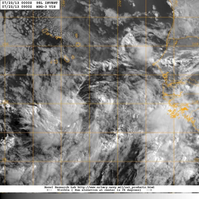
Re: ATL: INVEST 98L - Discussion
Nice looking 850mb vorticity.
http://tropic.ssec.wisc.edu/real-time/e ... wm7vor.GIF
It appears anti-cyclone is just to the NW of the LLC.
It will be tracking into a large slot of low-shear.
http://tropic.ssec.wisc.edu/real-time/e ... wm7shr.GIF
This may keep the vorticity column intact even though convection may diminish.
IMHO, SAL doesn't look all that bad immediately around it.
http://tropic.ssec.wisc.edu/real-time/sal/splitE.jpg
Looks like sporadic convection firing pretty close to the LLC
http://rammb.cira.colostate.edu/product ... 230330.jpg
Latest AMSU Sat Wind Analysis has a classic TD look.
http://rammb.cira.colostate.edu/product ... 0_SWHR.GIF
Latest pass from TRMM at 02:53Z had it's precip radar showing a small hot tower at 11N 24W
http://www.nrlmry.navy.mil/tcdat/tc13/A ... W.58pc.jpg
0 likes

Re:
fci wrote:Interesting to me that SST's are marginal at this time of the year.
Isn't that a bit unusual?
This time of the year that far east is not unusual for SSTs to only marginal for development, they don't really start warming up in that part of the Atlantic until the trade winds start dying down later in the summer.
0 likes
It seems to me that 98L has been moving almost due west during the night hugging the 12th latitude.
Not sure if that would last much longer with a weakness in the Atlantic ridge NW of 98L over the next couple of days.
However, the GFS builds one heck of a Central Atlantic ridge of 600 dm at h50 by Thursday that it shows to retrograde westward towards Bermuda by early next week. So if there is anything left of the system by then it should be on more westerly track through early next week.
0 likes
-
cycloneye

- Admin

- Posts: 149683
- Age: 69
- Joined: Thu Oct 10, 2002 10:54 am
- Location: San Juan, Puerto Rico
Re: ATL: INVEST 98L - Discussion
Here is the TWD Special Feature from 8 AM but came out early.
...SPECIAL FEATURES...
A TROPICAL WAVE ASSOCIATED WITH A 1010 MB SURFACE LOW HAS ITS
AXIS JUST E OF THE CAPE VERDE ISLANDS EXTENDING FROM 15N22W TO
07N23W AND MOVING W NEAR 5 KT. THIS SYSTEM IS EMBEDDED IN A HIGH
MOIST ENVIRONMENT AT THE LOWER AND MIDDLE LEVELS WHICH COMBINED
WITH UPPER LEVEL DIFFLUENCE IS SUPPORTING SCATTERED MODERATE
CONVECTION FROM 09N-13N BETWEEN 21W-27W. ENVIRONMENTAL
CONDITIONS ARE EXPECTED TO BECOME MORE FAVORABLE FOR TROPICAL
CYCLONE DEVELOPMENT. CURRENTLY...THERE IS A MEDIUM CHANCE FOR
THIS SYSTEM TO BECOME A TROPICAL CYCLONE DURING THE NEXT 48
HOURS.
0 likes
Visit the Caribbean-Central America Weather Thread where you can find at first post web cams,radars
and observations from Caribbean basin members Click Here
and observations from Caribbean basin members Click Here

Re:
Well, even though it may not be currently moving WNW, the TWO is referring to the average direction over the next 48 hours. At least, that's the way I understand it.TropicalAnalystwx13 wrote:West-northwest?
HIGHLY disagree.
0 likes
Who is online
Users browsing this forum: No registered users and 120 guests