ATL: INVEST 92L - Discussion

Moderator: S2k Moderators

Message
Author
User avatar
TropicalAnalystwx13
Category 5
Category 5
Posts: 2109
Age: 27
Joined: Tue Jul 19, 2011 8:20 pm
Location: Wilmington, NC
Contact:

#121 Postby TropicalAnalystwx13 » Tue Aug 13, 2013 9:49 pm

Red "VM" for vorticity maximum...blue "M" for mid-level circulation...yellow "ML" for monsoonal low.

This is where we'll begin to see if the ECMWF or GFS will be right. The ECMWF keeps the mid-level circulation the dominant feature and subsequently sends it into the Yucatan and across the Bay of Campeche with little consequence. The GFS, CMC, and FIM models, however, show the vorticity maximum becoming the dominant feature and intensifying, hitting the Yucatan Peninsula and being pulled north/north-northeast accordingly.

I'd side with the GFS, CMC, and FIM models for now. That's just me though.

Image
0 likes   

User avatar
cycloneye
Admin
Admin
Posts: 145281
Age: 68
Joined: Thu Oct 10, 2002 10:54 am
Location: San Juan, Puerto Rico

Re: ATL: INVEST 92L - Discussion

#122 Postby cycloneye » Tue Aug 13, 2013 9:54 pm

00z Surface Analysis by TAFB.

Image
0 likes   
Visit the Caribbean-Central America Weather Thread where you can find at first post web cams,radars
and observations from Caribbean basin members Click Here

JonathanBelles
Professional-Met
Professional-Met
Posts: 11430
Age: 35
Joined: Sat Dec 24, 2005 9:00 pm
Location: School: Florida State University (Tallahassee, FL) Home: St. Petersburg, Florida
Contact:

#123 Postby JonathanBelles » Tue Aug 13, 2013 9:56 pm

0 likes   

User avatar
Rgv20
S2K Supporter
S2K Supporter
Posts: 2466
Age: 38
Joined: Wed Jan 05, 2011 5:42 pm
Location: Edinburg/McAllen Tx

#124 Postby Rgv20 » Tue Aug 13, 2013 10:06 pm

OFFSHORE WATERS FORECAST FOR THE GULF OF MEXICO
NWS NATIONAL HURRICANE CENTER MIAMI FL
1034 PM EDT TUE AUG 13 2013

OFFSHORE WATERS FORECAST FOR THE GULF OF MEXICO

.SYNOPSIS...A TROPICAL WAVE WILL MOVE WEST NORTHWEST THROUGH THE
YUCATAN CHANNEL LATE WED. THE SOUTHERN PORTION OF THE WAVE WILL
CONTINUE WESTWARD REACHING THE MEXICAN COAST THIS WEEKEND ACCOMPANIED
BY LOW PRESSURE...POSSIBLY A TROPICAL CYCLONE...NEAR 21N ALONG
THE WAVE AXIS. THE NORTHERN PORTION OF THE TROPICAL WAVE WILL
MERGE WITH A TROUGH MOVING E THROUGH THE NE GULF WATERS FRI
THROUGH SUN.


http://www.nhc.noaa.gov/text/MIAOFFNT4.shtml
0 likes   
The following post is NOT an official forecast and should not be used as such. It is just the opinion of the poster and may or may not be backed by sound meteorological data. It is NOT endorsed by any professional institution including storm2k.org For Official Information please refer to the NHC and NWS products.

User avatar
tropicwatch
Category 5
Category 5
Posts: 3383
Age: 61
Joined: Sat Jun 02, 2007 10:01 am
Location: Panama City Florida
Contact:

#125 Postby tropicwatch » Tue Aug 13, 2013 10:09 pm

Kind of sticking there neck out a little with that forecast.
0 likes   
Tropicwatch


Agnes 72', Eloise 75, Elena 85', Kate 85', Charley 86', Florence 88', Beryl 94', Dean 95', Erin 95', Opal 95', Earl 98', Georges 98', Ivan 2004', Arlene 2005', Dennis 2005', Ida 2009' Debby 2012' Irma 2017' Michael 2018'

User avatar
weatherSnoop
S2K Supporter
S2K Supporter
Posts: 702
Age: 62
Joined: Wed Oct 09, 2002 10:06 pm
Location: Tampa, FL
Contact:

#126 Postby weatherSnoop » Tue Aug 13, 2013 10:20 pm

I am watching 15.5N 81.2 west. Not at the surface yet. Call it an eye for things, though I have very bad vision.

This is not a forecast and I am not trained in any way. Please refer to NHC for accurate analysis and potential threats.
0 likes   

User avatar
ROCK
Category 5
Category 5
Posts: 9484
Age: 54
Joined: Tue Aug 17, 2004 7:30 am
Location: Kemah, Texas

Re: ATL: INVEST 92L - Discussion

#127 Postby ROCK » Tue Aug 13, 2013 10:23 pm

cycloneye wrote:00z Surface Analysis by TAFB.

http://oi41.tinypic.com/2cf44r8.jpg


well the TAFB changed there map it seems.....
0 likes   

User avatar
galaxy401
Category 5
Category 5
Posts: 2419
Age: 30
Joined: Sat Aug 25, 2012 9:04 pm
Location: Casa Grande, Arizona

#128 Postby galaxy401 » Wed Aug 14, 2013 12:13 am

Convection flaring up again in a more concentrated area.
0 likes   
Got my eyes on moving right into Hurricane Alley: Florida.

User avatar
lester
S2K Supporter
S2K Supporter
Posts: 1305
Age: 36
Joined: Sat Aug 27, 2005 5:21 pm
Location: Washington, DC
Contact:

#129 Postby lester » Wed Aug 14, 2013 12:20 am

A TROPICAL WAVE OVER THE WESTERN CARIBBEAN SEA IS PRODUCING
DISORGANIZED SHOWER AND THUNDERSTORM ACTIVITY EXTENDING FROM
CENTRAL AMERICA NORTHEASTWARD TO JAMAICA AND EASTERN CUBA.
ENVIRONMENTAL CONDITIONS APPEAR CONDUCIVE FOR SOME DEVELOPMENT OF
THIS DISTURBANCE OVER THE NEXT COUPLE OF DAYS AS IT MOVES
NORTHWESTWARD AT 10 TO 15 MPH TOWARD THE YUCATAN PENINSULA AND
SOUTHERN GULF OF MEXICO. UPPER-LEVEL WINDS COULD BE MORE MARGINAL
FOR DEVELOPMENT WHILE THE SYSTEM IS OVER THE GULF OF MEXICO AT THE
END OF THE WEEK. THIS SYSTEM HAS A MEDIUM CHANCE...30 PERCENT...OF
BECOMING A TROPICAL CYCLONE DURING THE NEXT 48 HOURS...AND A MEDIUM
CHANCE...40 PERCENT...OF BECOMING A TROPICAL CYCLONE DURING THE
NEXT 5 DAYS.
0 likes   

HurricaneHunter914
Category 5
Category 5
Posts: 4439
Age: 31
Joined: Fri Mar 10, 2006 7:36 pm
Location: College Station, TX

#130 Postby HurricaneHunter914 » Wed Aug 14, 2013 3:34 am

Strong concentrated area of convection:
http://www.ssd.noaa.gov/PS/TROP/floater ... oater.html

Anticyclone positioned over that area with low wind shear and decreasing:
http://tropic.ssec.wisc.edu/real-time/w ... oom=&time=

Quickly improving conditions and 92L is responding well to them.
0 likes   
Personal Forecast Disclaimer:
The posts in this forum are NOT official forecast and should not be used as such. They are just the opinion of the poster and may or may not be backed by sound meteorological data. They are NOT endorsed by any professional institution or storm2k.org. For official information, please refer to the NHC and NWS products.

User avatar
GCANE
S2K Supporter
S2K Supporter
Posts: 11496
Joined: Mon Oct 22, 2007 8:03 am

Re: ATL: INVEST 92L - Discussion

#131 Postby GCANE » Wed Aug 14, 2013 3:53 am

Last OSCAT, about 4 hrs ago, showing 40 knot surface winds in the strong convection.

However, its all east winds.

http://www.nrlmry.navy.mil/tcdat/tc13/A ... 4_0000.jpg


Flare now firing up just to the northeast of the LLC.

Cold cloud tops; however, rain rate is light.

http://rammb.cira.colostate.edu/product ... 140045.jpg

http://www.ssd.noaa.gov/PS/TROP/floater ... -long.html

http://www.nrlmry.navy.mil/htdocs_dyn_a ... bean.0.jpg


Not benefiting from DMAX at the moment, looks like its on a slow brew.
0 likes   

User avatar
GCANE
S2K Supporter
S2K Supporter
Posts: 11496
Joined: Mon Oct 22, 2007 8:03 am

Re: ATL: INVEST 92L - Discussion

#132 Postby GCANE » Wed Aug 14, 2013 4:00 am

Very light NW winds at Utila, Honduras

http://www.wunderground.com/wundermap/? ... d.type=00Q
0 likes   

User avatar
GCANE
S2K Supporter
S2K Supporter
Posts: 11496
Joined: Mon Oct 22, 2007 8:03 am

Re: ATL: INVEST 92L - Discussion

#133 Postby GCANE » Wed Aug 14, 2013 4:02 am

Bluefields, Nicaragua

Winds out of NW, 5 mph

http://www.wunderground.com/cgi-bin/fin ... -83.769997
0 likes   

User avatar
GCANE
S2K Supporter
S2K Supporter
Posts: 11496
Joined: Mon Oct 22, 2007 8:03 am

#134 Postby GCANE » Wed Aug 14, 2013 4:36 am

0 likes   

User avatar
tropicwatch
Category 5
Category 5
Posts: 3383
Age: 61
Joined: Sat Jun 02, 2007 10:01 am
Location: Panama City Florida
Contact:

#135 Postby tropicwatch » Wed Aug 14, 2013 4:45 am

Noticed pressure down at that buoy to 1010mb.
0 likes   
Tropicwatch


Agnes 72', Eloise 75, Elena 85', Kate 85', Charley 86', Florence 88', Beryl 94', Dean 95', Erin 95', Opal 95', Earl 98', Georges 98', Ivan 2004', Arlene 2005', Dennis 2005', Ida 2009' Debby 2012' Irma 2017' Michael 2018'

User avatar
NDG
S2K Supporter
S2K Supporter
Posts: 15446
Joined: Sun Jul 09, 2006 10:14 pm
Location: Orlando, FL

#136 Postby NDG » Wed Aug 14, 2013 5:25 am

I hope Rock does not spill his coffee when he sees that his lovely ECMWF has let him down, for the who knows how many times this hurricane season so far, lol.
Like I said yesterday, it never fails, the euro has been horrible this year when going against the GFS, especially in the GOM.
0 likes   

User avatar
KatDaddy
Category 5
Category 5
Posts: 2815
Joined: Mon Oct 21, 2002 6:23 pm
Location: League City, Texas

#137 Postby KatDaddy » Wed Aug 14, 2013 5:53 am

Continuing to slow organize this morning. Awaiting additional model runs later this morning. Houston-Galveston AFD has nothing to say however the Corpus Christi AFD does make a mention:

SIGNIFICANT FORECAST CHANGES MAY BECOME
NECESSARY OVER THE NEXT SEVERAL DAYS BASED OFF FUTURE EVOLUTION OF
TROPICAL PARAMETERS.
0 likes   
The following post is NOT an official forecast and should not be used as such. It is just the opinion of the poster and may or may not be backed by sound meteorological data. It is NOT endorsed by any professional institution including storm2k.org For Official Information please refer to the NHC and NWS products.

Javlin
Category 5
Category 5
Posts: 1620
Age: 64
Joined: Fri Jul 09, 2004 7:58 pm
Location: ms gulf coast

Re: ATL: INVEST 92L - Discussion

#138 Postby Javlin » Wed Aug 14, 2013 6:01 am

Kinda tuff to tell but looks like alittle rotation @18N 81W by shortwave IR

http://www.ssd.noaa.gov/PS/TROP/floater ... -long.html
0 likes   

Dean4Storms
S2K Supporter
S2K Supporter
Posts: 6358
Age: 62
Joined: Sun Aug 31, 2003 1:01 pm
Location: Miramar Bch. FL

#139 Postby Dean4Storms » Wed Aug 14, 2013 6:06 am

Sure looks like we could get an LLC down under that deep convection today if it continues. Something developing that far east of the Yucatan would change everything in regards to any westward motion.
0 likes   

User avatar
NDG
S2K Supporter
S2K Supporter
Posts: 15446
Joined: Sun Jul 09, 2006 10:14 pm
Location: Orlando, FL

Re: ATL: INVEST 92L - Discussion

#140 Postby NDG » Wed Aug 14, 2013 6:14 am

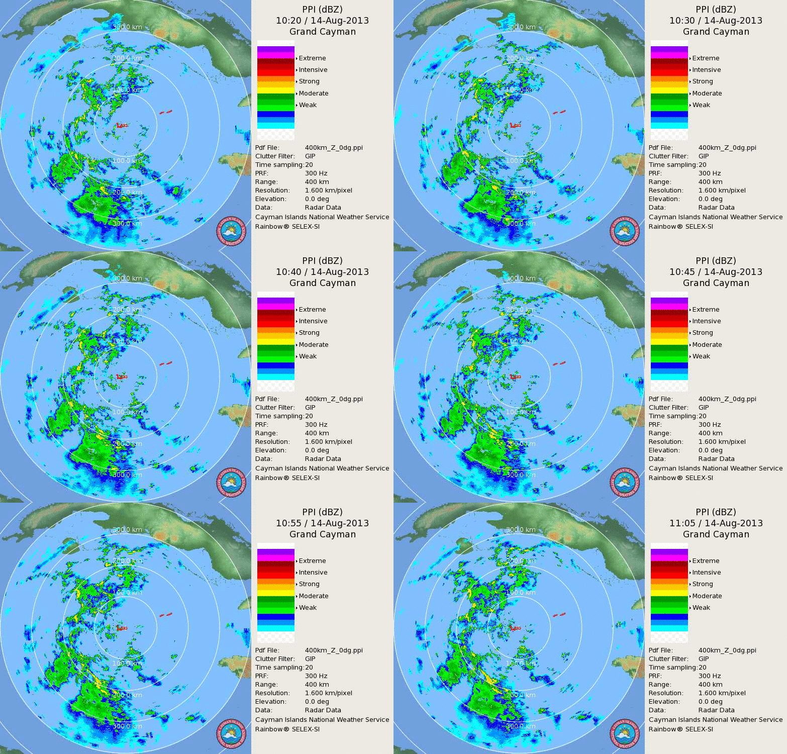
Saved radar loop from the Cayman Island, I know is at long range but you can clearly see the vorticity SW of the Islands.

Image
0 likes   


Return to “2013”

Who is online

Users browsing this forum: No registered users and 2 guests