ATL: INVEST 92L - Discussion

Moderator: S2k Moderators

Message
Author
User avatar
ROCK
Category 5
Category 5
Posts: 9484
Age: 54
Joined: Tue Aug 17, 2004 7:30 am
Location: Kemah, Texas

Re: ATL: INVEST 92L - Discussion

#101 Postby ROCK » Tue Aug 13, 2013 8:58 pm

Sanibel wrote:If that's the center it's going in low into Belize and should have to organize all over after Yucatan. (If it tracks west like it's doing)


thats pretty much what the NAM,EURO,UKMET, the 0z BAMM suite are showing....
0 likes   

Dean4Storms
S2K Supporter
S2K Supporter
Posts: 6358
Age: 62
Joined: Sun Aug 31, 2003 1:01 pm
Location: Miramar Bch. FL

Re: ATL: INVEST 92L - Discussion

#102 Postby Dean4Storms » Tue Aug 13, 2013 9:00 pm

ROCK wrote:http://www.ssd.noaa.gov/PS/TROP/floaters/92L/flash-avn-long.html

looks totally organized tonight. :lol: ...that anticyclone is sitting right on top of the MLC and likely moving with it


http://tropic.ssec.wisc.edu/real-time/w ... oom=&time=


Did you notice the 3 hr step direction there Rock? It's moved northward more since this.
0 likes   

hurricanehunter69
Category 1
Category 1
Posts: 343
Joined: Sun May 16, 2010 5:21 pm
Location: New Orleans

Re: ATL: INVEST 92L - Discussion

#103 Postby hurricanehunter69 » Tue Aug 13, 2013 9:02 pm

A good friend of mine is having an outdoor wedding this saturday.... right off the beach. So, as much as I hate to say it. You can put me down with the NGOM solution (camp). Based on the fact that there is a clear weakness in the central gulf, and the system appears to be developing well. Although I'm thinking it won't really matter where the llc initializes, I'll still go with the llc initializing farther north in the NW caribbean.
0 likes   

Dean4Storms
S2K Supporter
S2K Supporter
Posts: 6358
Age: 62
Joined: Sun Aug 31, 2003 1:01 pm
Location: Miramar Bch. FL

#104 Postby Dean4Storms » Tue Aug 13, 2013 9:03 pm

If that MLC keeps moving WNW with the Anticyclone moving north that MLC is finished IMO.
0 likes   
My opinion and statements DO NOT represent the opinion of the EMA, NHC, NWS, or any other professional agency, organization, or group. For official information, please refer to the NHC and NWS products.

ozonepete
Professional-Met
Professional-Met
Posts: 4743
Joined: Mon Sep 07, 2009 3:23 pm
Location: From Ozone Park, NYC / Now in Brooklyn, NY

Re: ATL: INVEST 92L - Discussion

#105 Postby ozonepete » Tue Aug 13, 2013 9:06 pm

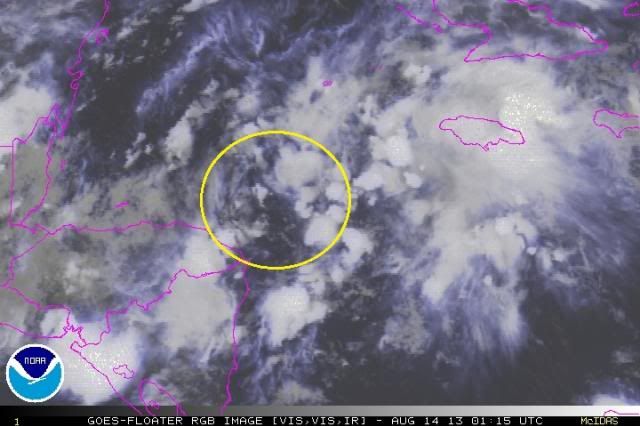
Well now that the floater's up I can get a better fix. The current COC surely looks to be where I circled it. There still is a lot of jockeying underneath the whole system for which area will take over, and the point that the southern low could collapse over land and the COC develop further north over the northern Yucatan still must be considered, but if this COC holds and an LLC gets established down there, it would surely favor a more southern track. Just sayin' what I see. :wink:

Image
0 likes   

Dean4Storms
S2K Supporter
S2K Supporter
Posts: 6358
Age: 62
Joined: Sun Aug 31, 2003 1:01 pm
Location: Miramar Bch. FL

Re: ATL: INVEST 92L - Discussion

#106 Postby Dean4Storms » Tue Aug 13, 2013 9:07 pm

ozonepete wrote:Well now that the floater's up I can get a better fix. The current COC surely looks to be where I circled it. There still is a lot of jockeying underneath the whole system for which area will take over, and the point that the southern low could collapse over land and the COC develop further north over the northern Yucatan still must be considered, but if this COC holds and an LLC gets established down there, it would surely favor a more southern track. Just sayin' what I see. :wink:

http://i189.photobucket.com/albums/z174/philnyc_2007/satrgb2013-08-140115anno_zpsd63ec53e.jpg


Just don't see an LLC getting established down there with the Anticyclone moving north, see Rocks link and 3hr step.
0 likes   

User avatar
ROCK
Category 5
Category 5
Posts: 9484
Age: 54
Joined: Tue Aug 17, 2004 7:30 am
Location: Kemah, Texas

Re: ATL: INVEST 92L - Discussion

#107 Postby ROCK » Tue Aug 13, 2013 9:08 pm

yeah Dean those maps are not always right on...

But if you want to hang your cowbot hat on the northern route thats cool....you are just going against the HPC in coordination with the NHC and about 2 NWS offices that I know of....good luck!!! :lol:
0 likes   

User avatar
ROCK
Category 5
Category 5
Posts: 9484
Age: 54
Joined: Tue Aug 17, 2004 7:30 am
Location: Kemah, Texas

Re: ATL: INVEST 92L - Discussion

#108 Postby ROCK » Tue Aug 13, 2013 9:10 pm

OZ thats where I have it and been watching it all day....we shall see...HPC discussion was very interesting...
0 likes   

User avatar
ronjon
Category 5
Category 5
Posts: 4822
Joined: Fri Aug 19, 2005 5:17 pm
Location: Hernando Beach, FL

Re: ATL: INVEST 92L - Discussion

#109 Postby ronjon » Tue Aug 13, 2013 9:13 pm

Yeah Rock but the TAFB 72 hour forecast from the NHC goes with the northern solution. In fact, the GFS shows the greatest vorticity off the NIC coast but moves it inland in 18 hrs.
0 likes   

User avatar
ronjon
Category 5
Category 5
Posts: 4822
Joined: Fri Aug 19, 2005 5:17 pm
Location: Hernando Beach, FL

Re: ATL: INVEST 92L - Discussion

#110 Postby ronjon » Tue Aug 13, 2013 9:17 pm

Of course that circled area is a little further north than what the GFS shows but it's also pretty devoid of convection.
0 likes   

Dean4Storms
S2K Supporter
S2K Supporter
Posts: 6358
Age: 62
Joined: Sun Aug 31, 2003 1:01 pm
Location: Miramar Bch. FL

#111 Postby Dean4Storms » Tue Aug 13, 2013 9:20 pm

I'm at a loss why you think the southern part soon to be inland will be the show when well north we have deepening convection and also vorticity? If there was no convection firing to the north tonight I would agree with the southern system being the main player here, but that is not what I'm seeing.
0 likes   

User avatar
Steve
S2K Supporter
S2K Supporter
Posts: 9620
Joined: Sat Apr 05, 2003 11:41 pm
Location: Not a state-caster

#112 Postby Steve » Tue Aug 13, 2013 9:23 pm

Haven't watched the video yet, but i could definitely see split energy. You would usually expect low pressure anyway running up and out front of a trough that set up along or just off the Gulf Coast whether it was a winter, spring, subtropical or tropical Low. And the energy out front the trough is juiced. This is like the 4th storm today in Nola. So theres no reason a piece of 92l or its energy shouldn't head for the panhandle. Plus it's a split pattern anyway. The upper low that is preceding the pattern reversal over top of 92l and the western caribbean split off from a TUTT the other day. It would make sense for both model camps if another piece, likely the wave axis, continued on into the sw gulf or BOC whether or not it ever becomes much. Also, I still expect energy to be there based on utor's track. That WPAC ridging has been solid. And if it isn't telegraphing 92l, then it says there will be strong ridging into the SE US in a few days.

This post is NOT official information.
Last edited by Steve on Tue Aug 13, 2013 9:26 pm, edited 3 times in total.
0 likes   

Dean4Storms
S2K Supporter
S2K Supporter
Posts: 6358
Age: 62
Joined: Sun Aug 31, 2003 1:01 pm
Location: Miramar Bch. FL

#113 Postby Dean4Storms » Tue Aug 13, 2013 9:24 pm

I guess it is not out of the question either that we have a split here with the southern circulation heading more westward toward the BOC while the northern part develops as they separate in miles with it moving more NW. I don't know, think we get more answers tomorrow.
0 likes   

ozonepete
Professional-Met
Professional-Met
Posts: 4743
Joined: Mon Sep 07, 2009 3:23 pm
Location: From Ozone Park, NYC / Now in Brooklyn, NY

Re: ATL: INVEST 92L - Discussion

#114 Postby ozonepete » Tue Aug 13, 2013 9:28 pm

Dean4Storms wrote:
ozonepete wrote:Well now that the floater's up I can get a better fix. The current COC surely looks to be where I circled it. There still is a lot of jockeying underneath the whole system for which area will take over, and the point that the southern low could collapse over land and the COC develop further north over the northern Yucatan still must be considered, but if this COC holds and an LLC gets established down there, it would surely favor a more southern track. Just sayin' what I see. :wink:

http://i189.photobucket.com/albums/z174/philnyc_2007/satrgb2013-08-140115anno_zpsd63ec53e.jpg


Just don't see an LLC getting established down there with the Anticyclone moving north, see Rocks link and 3hr step.


Ok, two points now. Remember that the anticyclone doesn't necessarily drive where the low develops. It's much more important where a good mid to low level circulation (and pressure drop) gets established AND convection builds over it. The increased convection around a good mid to low level circulation is what eventually helps establish an anti-cyclone over it. Anti-cyclones moving in over a disturbed area or weak low pressure don't cause a low to develop under them. But the other point is that even if the low is where I circled it and this basically maintains itself, it could still move much more to the NNW rather than west or northwest anyway - the models have so far had this developing center jumping all over the place as it develops. So I shouldn't have really said the current COC position "surely" favors a more southern track. It makes it more likely, but some of the model runs for the last few days had the low where I circled it and still jumped it north and then up to the central GOM coast anyway.
0 likes   

User avatar
ROCK
Category 5
Category 5
Posts: 9484
Age: 54
Joined: Tue Aug 17, 2004 7:30 am
Location: Kemah, Texas

Re: ATL: INVEST 92L - Discussion

#115 Postby ROCK » Tue Aug 13, 2013 9:32 pm

I am at a loss......well of convection.. :lol: :lol: ..doesnt look to organized attm...just sayin..

Image
0 likes   

Dean4Storms
S2K Supporter
S2K Supporter
Posts: 6358
Age: 62
Joined: Sun Aug 31, 2003 1:01 pm
Location: Miramar Bch. FL

Re: ATL: INVEST 92L - Discussion

#116 Postby Dean4Storms » Tue Aug 13, 2013 9:41 pm

ozonepete wrote:
Dean4Storms wrote:
ozonepete wrote:Well now that the floater's up I can get a better fix. The current COC surely looks to be where I circled it. There still is a lot of jockeying underneath the whole system for which area will take over, and the point that the southern low could collapse over land and the COC develop further north over the northern Yucatan still must be considered, but if this COC holds and an LLC gets established down there, it would surely favor a more southern track. Just sayin' what I see. :wink:

http://i189.photobucket.com/albums/z174/philnyc_2007/satrgb2013-08-140115anno_zpsd63ec53e.jpg


Just don't see an LLC getting established down there with the Anticyclone moving north, see Rocks link and 3hr step.


Ok, two points now. Remember that the anticyclone doesn't necessarily drive where the low develops. It's much more important where a good mid to low level circulation (and pressure drop) gets established AND convection builds over it. The increased convection around a good mid to low level circulation is what eventually helps establish an anti-cyclone over it. Anti-cyclones moving in over a disturbed area or weak low pressure don't cause a low to develop under them. But the other point is that even if the low is where I circled it and this basically maintains itself, it could still move much more to the NNW rather than west or northwest anyway - the models have so far had this developing center jumping all over the place as it develops. So I shouldn't have really said the current COC position "surely" favors a more southern track. It makes it more likely, but some of the model runs for the last few days had the low where I circled it and still jumped it north and then up to the central GOM coast anyway.


Good points!
0 likes   

ozonepete
Professional-Met
Professional-Met
Posts: 4743
Joined: Mon Sep 07, 2009 3:23 pm
Location: From Ozone Park, NYC / Now in Brooklyn, NY

Re: ATL: INVEST 92L - Discussion

#117 Postby ozonepete » Tue Aug 13, 2013 9:43 pm

:uarrow: Thanks, Dean. And as you said we need to wait and watch. It's still way too early.
0 likes   

Dean4Storms
S2K Supporter
S2K Supporter
Posts: 6358
Age: 62
Joined: Sun Aug 31, 2003 1:01 pm
Location: Miramar Bch. FL

#118 Postby Dean4Storms » Tue Aug 13, 2013 9:45 pm

Actually when you follow the GFS it doesn't really even close off a low until it gets north of the Yucatan in the southern Gulf.
0 likes   

TheStormExpert

#119 Postby TheStormExpert » Tue Aug 13, 2013 9:47 pm

TWC thinks 92L is more likely to get pulled towards the Northern Gulf Coast by the trough.
0 likes   

Bailey1777
S2K Supporter
S2K Supporter
Posts: 962
Joined: Mon Jul 31, 2006 6:23 pm
Location: Houston, Texas

#120 Postby Bailey1777 » Tue Aug 13, 2013 9:49 pm

rock what was the hpc disscussion
0 likes   


Return to “2013”

Who is online

Users browsing this forum: No registered users and 9 guests