
SUMMARY OF 200 AM AST...0600 UTC...INFORMATION
----------------------------------------------
LOCATION...25.0N 68.7W
ABOUT 555 MI...895 KM SSW OF BERMUDA
MAXIMUM SUSTAINED WINDS...125 MPH...205 KM/H
PRESENT MOVEMENT...N OR 360 DEGREES AT 9 MPH...15 KM/H
MINIMUM CENTRAL PRESSURE...953 MB...28.15 INCHES
I stand corrected about no more strengthening.
ATL: GONZALO - Post-Tropical - Discussion
Moderator: S2k Moderators
Re: ATL: GONZALO - Hurricane - Discussion
0 likes
The above post is not official and should not be used as such. It is the opinion of the poster and may or may not be backed by sound meteorological data. It is not endorsed by any professional institution or storm2k.org. For official information, please refer to the NHC and NWS products.

Re: ATL: GONZALO - Hurricane - Discussion
The Donut returns, and bigger than before!
Let's see what this beast does as it begins shooting NNE...will it continue blowing up as it heads for Bermuda? or will shear weaken it a bit as it gets shoved that way? I feel these are the big questions now in play. It definitely looks like it's getting stronger on satellite. It's gonna be a stunner on the visible come morning daylight!
Let's see what this beast does as it begins shooting NNE...will it continue blowing up as it heads for Bermuda? or will shear weaken it a bit as it gets shoved that way? I feel these are the big questions now in play. It definitely looks like it's getting stronger on satellite. It's gonna be a stunner on the visible come morning daylight!
0 likes
Georges '98, Irene '99, Frances '04, Jeanne '04, Katrina '05, Wilma '05, Gustav '08, Isaac '12, Matthew '16, Florence '18, Michael '18, Ian '22
Re:
spiral wrote:looks closer to 110 knots down a bit but still a major powerful cane.
110kts = 125mph, so it's actually at that intensity.
I'm hoping this weakens quickly as it approaches Bermuda, but in the meantime, I'm hoping it can hold it's organization through the next recon cycle so we can get a good measurement of the current intensity, as it appears to have strengthened even over the last hour.
0 likes
The above post is not official and should not be used as such. It is the opinion of the poster and may or may not be backed by sound meteorological data. It is not endorsed by any professional institution or storm2k.org. For official information, please refer to the NHC and NWS products.
-
brunota2003

- S2K Supporter

- Posts: 9476
- Age: 35
- Joined: Sat Jul 30, 2005 9:56 pm
- Location: Stanton, KY...formerly Havelock, NC
- Contact:
Re:
CrazyC83 wrote:The 114 kt SFMR was in moderate rain - enough to make it questionable?
The 114 knot SFMR reading had rain of 39mm, I consider anything over 10mm "suspect". Once you get above about 9 or 10, the rain starts inflating the wind speed.
0 likes
Just a small town southern boy helping other humans.
-
EquusStorm
- Category 5

- Posts: 1649
- Age: 35
- Joined: Thu Nov 07, 2013 1:04 pm
- Location: Jasper, AL
- Contact:
Re: ATL: GONZALO - Hurricane - Discussion
Gracious. Just look at the organization. I stand corrected in assuming that Gonzalo wouldn't regain its former glory in this second round of intensification. That said, it's only got a short window left to do too much more. The trough is approaching pretty fast. Were I in Bermuda, I would be very concerned.

Last edited by EquusStorm on Thu Oct 16, 2014 2:48 am, edited 1 time in total.
0 likes
Colors of lost purpose on the canvas of irrelevance
Not a meteorologist, in fact more of an idiot than anything. You should probably check with the NHC or a local NWS office for official information.
Not a meteorologist, in fact more of an idiot than anything. You should probably check with the NHC or a local NWS office for official information.
08L GONZALO 141016 0600 25.0N 68.7W ATL 115 949
120-125kts doesn't look too unrealistic for the peak if it strengthens through today.
120-125kts doesn't look too unrealistic for the peak if it strengthens through today.
0 likes
The above post is not official and should not be used as such. It is the opinion of the poster and may or may not be backed by sound meteorological data. It is not endorsed by any professional institution or storm2k.org. For official information, please refer to the NHC and NWS products.

-
EquusStorm
- Category 5
- Posts: 1649
- Age: 35
- Joined: Thu Nov 07, 2013 1:04 pm
- Location: Jasper, AL
- Contact:
I would just like to see it hurry up and dip to 939mb and beat out Ophelia and Sandy for most intense storm since 2010 before weakening and passing by Bermuda. Honestly, it could happen. It would only take, what, an additional 10mb drop through the next day or so?
Also I kind of think the core structure reorganization is a pretty bad thing for Bermuda... the hurricane force wind radius has nearly doubled, though it's still fairly compact. I hope not, but I can't help but wonder if in the future we'll think of Gonzalo as 'Fabian Part Two: The October Redux, Now With Added Caribbean Impact!'
Also I kind of think the core structure reorganization is a pretty bad thing for Bermuda... the hurricane force wind radius has nearly doubled, though it's still fairly compact. I hope not, but I can't help but wonder if in the future we'll think of Gonzalo as 'Fabian Part Two: The October Redux, Now With Added Caribbean Impact!'
0 likes
Colors of lost purpose on the canvas of irrelevance
Not a meteorologist, in fact more of an idiot than anything. You should probably check with the NHC or a local NWS office for official information.
Not a meteorologist, in fact more of an idiot than anything. You should probably check with the NHC or a local NWS office for official information.
-
TheStormExpert
-
brunota2003
- S2K Supporter
- Posts: 9476
- Age: 35
- Joined: Sat Jul 30, 2005 9:56 pm
- Location: Stanton, KY...formerly Havelock, NC
- Contact:
-
beoumont

- Category 1

- Posts: 473
- Joined: Sun Jul 10, 2011 4:13 pm
- Location: East Central Florida
- Contact:
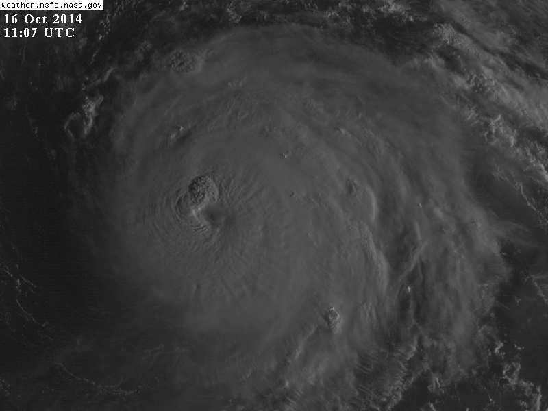
Re: ATL: GONZALO - Hurricane - Discussion
1st visible, Godzilla:
Also, recon at 8600 ft had 937.5 mb, not yet corrected/ or adjusted.
Also, recon at 8600 ft had 937.5 mb, not yet corrected/ or adjusted.
Last edited by beoumont on Thu Oct 16, 2014 6:36 am, edited 2 times in total.
0 likes
List of 79 tropical cyclones intercepted by Richard Horodner:
http://www.canebeard.com/page/page/572246.htm
http://www.canebeard.com/page/page/572246.htm
-
supercane4867
- Category 5
- Posts: 4966
- Joined: Wed Nov 14, 2012 10:43 am
Central pressure maybe near 939mb based on dropsonde
Last edited by supercane4867 on Thu Oct 16, 2014 6:41 am, edited 2 times in total.
0 likes


Re:
Speaking under correction, the 140 mph MSW intensity at 5 AM is actually the most powerful Gonzalo has ever been. Should be interesting to see what it is at 8 AM.brunota2003 wrote:The 5 am advisory has the hurricane back to 120 knots, Category 4 again.
EDIT: Thankfully, it's still at 140 mph in the 8 AM update.
0 likes
-
TheStormExpert
Re: Re:
abajan wrote:Speaking under correction, the 140 mph MSW intensity at 5 AM is actually the most powerful Gonzalo has ever been. Should be interesting to see what it is at 8 AM.brunota2003 wrote:The 5 am advisory has the hurricane back to 120 knots, Category 4 again.
EDIT: Thankfully, it's still at 140 mph in the 8 AM update.
Pressure dropped though 5mb, now 940mb.
0 likes
-
northjaxpro

- S2K Supporter
- Posts: 8900
- Joined: Mon Sep 27, 2010 11:21 am
- Location: Jacksonville, FL
Gonzalo is as impressive as a hurricane can appear right now. Classic, textbook hurricane for certain.
Praying for all on Bermuda as this monstruous storm approaches.
Praying for all on Bermuda as this monstruous storm approaches.
0 likes
NEVER, EVER SAY NEVER in the tropics and weather in general, and most importantly, with life itself!!
________________________________________________________________________________________
Fay 2008 Beryl 2012 Debby 2012 Colin 2016 Hermine 2016 Julia 2016 Matthew 2016 Irma 2017 Dorian 2019
________________________________________________________________________________________
Fay 2008 Beryl 2012 Debby 2012 Colin 2016 Hermine 2016 Julia 2016 Matthew 2016 Irma 2017 Dorian 2019
-
supercane4867
- Category 5
- Posts: 4966
- Joined: Wed Nov 14, 2012 10:43 am
Re: ATL: GONZALO - Hurricane - Discussion
They kept intensity unchanged because the NE quadrant has yet to be sampled by recon
0 likes
-
supercane4867
- Category 5
- Posts: 4966
- Joined: Wed Nov 14, 2012 10:43 am


-
supercane4867
- Category 5
- Posts: 4966
- Joined: Wed Nov 14, 2012 10:43 am
Re: ATL: GONZALO - Hurricane - Discussion
135kt SFMR wind reported in NE eyewall with moderate rain
0 likes
Who is online
Users browsing this forum: No registered users and 9 guests