ATL: GONZALO - Post-Tropical - Discussion

Moderator: S2k Moderators

Message
Author
CrazyC83
Professional-Met
Professional-Met
Posts: 34002
Joined: Tue Mar 07, 2006 11:57 pm
Location: Deep South, for the first time!

Re: Re:

#761 Postby CrazyC83 » Wed Oct 15, 2014 8:46 pm

chaser1 wrote:
Alyono wrote:I'll take the wager Hammy

I'll put $500 on it that this will not be down to a cat 1 tomorrow


Tempting be Alyono, and was about to jump on the bandwagon with you, but jeez... looking at the buzz-saw shear advancing from the west. Gustavo is resembling the 'ol "suicide squeeze play" in baseball. At least temporarily it appears that the vort. max is swinging around the west side of the eye and for the moment is at least helping warm the atmosphere so to perhaps hold off approaching shear temporarily. But to be able to stave off that shear for a full 24 hours?? I don't know, hard for me to see that. Makes for a fun bet and discussion though


Once it gets into higher latitudes (in October that would be north of 30N), shear becomes less important as it starts to transition to extratropical.
0 likes   

User avatar
cycloneye
Admin
Admin
Posts: 145323
Age: 68
Joined: Thu Oct 10, 2002 10:54 am
Location: San Juan, Puerto Rico

Re: ATL: GONZALO - Hurricane - Discussion

#762 Postby cycloneye » Wed Oct 15, 2014 8:51 pm

Is 105 but they could go with 100 as Crazy said.

AL, 08, 2014101600, , BEST, 0, 243N, 686W, 105, 953, HU
0 likes   
Visit the Caribbean-Central America Weather Thread where you can find at first post web cams,radars
and observations from Caribbean basin members Click Here

User avatar
xtyphooncyclonex
Category 5
Category 5
Posts: 3861
Age: 23
Joined: Sat Dec 08, 2012 9:07 am
Location: Cebu City
Contact:

#763 Postby xtyphooncyclonex » Wed Oct 15, 2014 8:53 pm

I would say that on Microwave imagery, it looks 120 kts however 105 kts on satellite and recon, which would mean that the best estimate would be close to 110 kts. As the EWRC had completed, it may linger or even strengthen a bit. Given that as this has sustained its strength for quite long (110-115), it may be in the neighborhood of 85-105 kts tomorrow. Agree? OR Disagree?

AND FYI This is the most impressive ATL storm that I've ever tracked, since I rarely follow the basin. :ggreen: :cheesy:
0 likes   
REMINDER: My opinions that I, or any other NON Pro-Met in this forum, are unofficial. Please do not take my opinions as an official forecast and warning. I am NOT a meteorologist. Following my forecasts blindly may lead to false alarm, danger and risk if official forecasts from agencies are ignored.

CrazyC83
Professional-Met
Professional-Met
Posts: 34002
Joined: Tue Mar 07, 2006 11:57 pm
Location: Deep South, for the first time!

#764 Postby CrazyC83 » Wed Oct 15, 2014 8:57 pm

One thing for sure, the storm has grown in size in terms of tropical storm wind field...
0 likes   

User avatar
Hammy
Category 5
Category 5
Posts: 5849
Age: 41
Joined: Fri May 25, 2012 5:25 pm
Contact:

Re:

#765 Postby Hammy » Wed Oct 15, 2014 9:05 pm

CrazyC83 wrote:One thing for sure, the storm has grown in size in terms of tropical storm wind field...


Would that, along with the ERC, explain why the weakening occurred without a pressure drop?
0 likes   
The above post is not official and should not be used as such. It is the opinion of the poster and may or may not be backed by sound meteorological data. It is not endorsed by any professional institution or storm2k.org. For official information, please refer to the NHC and NWS products.

CrazyC83
Professional-Met
Professional-Met
Posts: 34002
Joined: Tue Mar 07, 2006 11:57 pm
Location: Deep South, for the first time!

Re: Re:

#766 Postby CrazyC83 » Wed Oct 15, 2014 9:10 pm

Hammy wrote:
CrazyC83 wrote:One thing for sure, the storm has grown in size in terms of tropical storm wind field...


Would that, along with the ERC, explain why the weakening occurred without a pressure drop?


Most likely. Sometimes the pressure can fall even with weakening, such as with Dean and Irene.
0 likes   

User avatar
JtSmarts
S2K Supporter
S2K Supporter
Posts: 1437
Age: 39
Joined: Thu Jul 10, 2003 1:29 pm
Location: Columbia, South Carolina

Re: ATL: GONZALO - Hurricane - Discussion

#767 Postby JtSmarts » Wed Oct 15, 2014 9:20 pm

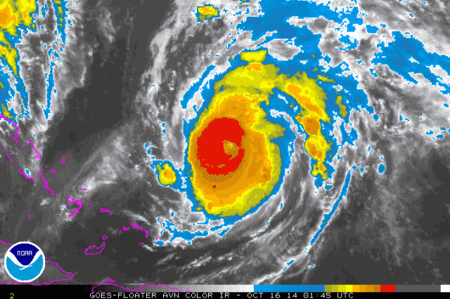
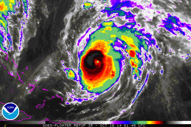
Looks like the eye may try to reemerge soon on ir.

http://www.ssd.noaa.gov/PS/TROP/floater ... -long.html
0 likes   

ozonepete
Professional-Met
Professional-Met
Posts: 4743
Joined: Mon Sep 07, 2009 3:23 pm
Location: From Ozone Park, NYC / Now in Brooklyn, NY

Re: ATL: GONZALO - Hurricane - Discussion

#768 Postby ozonepete » Wed Oct 15, 2014 9:25 pm

JtSmarts wrote:Looks like the eye may try to reemerge soon on ir.

http://www.ssd.noaa.gov/PS/TROP/floater ... -long.html


It's there, very clear.

Image

Image
0 likes   

ozonepete
Professional-Met
Professional-Met
Posts: 4743
Joined: Mon Sep 07, 2009 3:23 pm
Location: From Ozone Park, NYC / Now in Brooklyn, NY

Re:

#769 Postby ozonepete » Wed Oct 15, 2014 9:26 pm

spiral wrote:Still has a minimal of at-least 5 towers lighting up in the NE core and a few in the feeder bands. Still looks 115 knot storm.


No matter what the intensity really is right now I'd have to agree it looks 115 knots in the last few frames. I think it's RI'ing again.
0 likes   

hurricanes1234
Category 5
Category 5
Posts: 2907
Joined: Sat Jul 28, 2012 6:19 pm
Location: Trinidad and Tobago

#770 Postby hurricanes1234 » Wed Oct 15, 2014 9:29 pm

Agreed, looks good again with the eye seemingly reappearing, could this be strengthening again?
0 likes   
PLEASE NOTE: With the exception of information from weather agencies that I may copy and paste here, my posts will NEVER be official, since I am NOT a meteorologist. They are solely my amateur opinion, and may or may not be accurate. Therefore, please DO NOT use them as official details, particularly when making important decisions. Thank you.

User avatar
Kingarabian
S2K Supporter
S2K Supporter
Posts: 15981
Joined: Sat Aug 08, 2009 3:06 am
Location: Honolulu, Hawaii

#771 Postby Kingarabian » Wed Oct 15, 2014 9:41 pm

Hope Bermuda is prepared.
0 likes   
RIP Kobe Bryant

User avatar
JtSmarts
S2K Supporter
S2K Supporter
Posts: 1437
Age: 39
Joined: Thu Jul 10, 2003 1:29 pm
Location: Columbia, South Carolina

#772 Postby JtSmarts » Wed Oct 15, 2014 9:41 pm

It's been an adjustment seeing 115 kt and not thinking 135 mph.
0 likes   

User avatar
MGC
S2K Supporter
S2K Supporter
Posts: 5899
Joined: Sun Mar 23, 2003 9:05 pm
Location: Pass Christian MS, or what is left.

Re: ATL: GONZALO - Hurricane - Discussion

#773 Postby MGC » Wed Oct 15, 2014 9:46 pm

Last VDM reported an 18NM eye that was open to the south. Since that report, it appears that Gonzalo's eye has become better defined looking at the IR loop. So to me it looks to be slightly stronger....but that is just my amateur opinion. Wonder how the wind field has reacted to the EWRC?.....MGC
0 likes   

CrazyC83
Professional-Met
Professional-Met
Posts: 34002
Joined: Tue Mar 07, 2006 11:57 pm
Location: Deep South, for the first time!

#774 Postby CrazyC83 » Wed Oct 15, 2014 9:48 pm

Recon is definitely having issues transmitting tonight.
0 likes   

ozonepete
Professional-Met
Professional-Met
Posts: 4743
Joined: Mon Sep 07, 2009 3:23 pm
Location: From Ozone Park, NYC / Now in Brooklyn, NY

Re: ATL: GONZALO - Hurricane - Discussion

#775 Postby ozonepete » Wed Oct 15, 2014 9:56 pm

It has clearly done the first part of the expected recurve and is moving northward now. A lot of times as these recurve because of an approaching trough they slow down and lose some intensity but then can ramp up one more time before the trough starts a stronger interaction with them. That trough is getting close but not close enough to exchange dry continental air with it yet. That may be why the western side got ragged for a while today but seems to be smoothing out again now.
0 likes   

tolakram
Admin
Admin
Posts: 20009
Age: 62
Joined: Sun Aug 27, 2006 8:23 pm
Location: Florence, KY (name is Mark)

Re: ATL: GONZALO - Hurricane - Discussion

#776 Postby tolakram » Wed Oct 15, 2014 10:15 pm

0 likes   
M a r k
- - - - -
Join us in chat: Storm2K Chatroom Invite. Android and IOS apps also available.

The posts in this forum are NOT official forecasts and should not be used as such. Posts are NOT endorsed by any professional institution or STORM2K.org. For official information and forecasts, please refer to NHC and NWS products.

supercane4867
Category 5
Category 5
Posts: 4966
Joined: Wed Nov 14, 2012 10:43 am

Re: ATL: GONZALO - Hurricane - Discussion

#777 Postby supercane4867 » Wed Oct 15, 2014 10:38 pm

ADT raw T-number upped to 6.3 as cloud tops cooling significantly with -70°C ring surrounding the eye

CI# /Pressure/ Vmax
5.0 / 968.5mb/ 90.0kt

Final T# Adj T# Raw T#
5.0 5.4 6.3

Center Temp : -26.2C Cloud Region Temp : -71.6C

Scene Type : EYE

Image
0 likes   

User avatar
Ptarmigan
Category 5
Category 5
Posts: 5313
Joined: Wed Aug 16, 2006 9:06 pm

Re: ATL: GONZALO - Hurricane - Discussion

#778 Postby Ptarmigan » Wed Oct 15, 2014 10:40 pm

953 millibars and 120 mph winds is about normal. I have seen Category 2 to 4 hurricanes with that pressure. It is due to ambient pressure or size. Smaller have tighter gradients and stronger winds.
0 likes   

CrazyC83
Professional-Met
Professional-Met
Posts: 34002
Joined: Tue Mar 07, 2006 11:57 pm
Location: Deep South, for the first time!

#779 Postby CrazyC83 » Wed Oct 15, 2014 10:47 pm

The 114 kt SFMR was in moderate rain - enough to make it questionable?
0 likes   

User avatar
EquusStorm
Category 5
Category 5
Posts: 1649
Age: 34
Joined: Thu Nov 07, 2013 1:04 pm
Location: Jasper, AL
Contact:

#780 Postby EquusStorm » Wed Oct 15, 2014 11:34 pm

Well color me impressed, the ol' boy looks like he's gotten his second wind tonight. A larger and much more pronounced eye is evident and the eyewall looks about as organized as it's ever been. The storm's overall a little more symmetrical too. It doesn't have long to try to regain a little intensity though, violent shear is already apparent not too far off to the west.

Image
0 likes   
Colors of lost purpose on the canvas of irrelevance

Not a meteorologist, in fact more of an idiot than anything. You should probably check with the NHC or a local NWS office for official information.


Return to “2014”

Who is online

Users browsing this forum: No registered users and 8 guests