ATL: Ex NINE

Moderator: S2k Moderators

Message
Author
ozonepete
Professional-Met
Professional-Met
Posts: 4743
Joined: Mon Sep 07, 2009 3:23 pm
Location: From Ozone Park, NYC / Now in Brooklyn, NY

Re:

#681 Postby ozonepete » Sun Oct 26, 2014 5:38 pm

gatorcane wrote:We are seeing signs of organization the past several hours. Water temps are around 84F where this invest is located and deep convection with high towers continues to blow up right over the area of vorticity. I am still not seeing any movement either. Look at that huge upper-high right on top (second image below). We are witnessing the power of the NW Caribbean. All this invest needed was its window of opportunity and look what is happening. That is why any kind of vorticity in the NW Caribbean this time of year needs close watching.

http://i60.tinypic.com/316t21e.jpg

http://i62.tinypic.com/2ljt8ch.jpg


The upper level anticyclone is providing really impressive outflow. You can see the cirrus radiating outward in a clockwise manner over the top of this. That's why thunderstorms keep re-exploding. The upper air is being evacuated very efficiently.
0 likes   

ozonepete
Professional-Met
Professional-Met
Posts: 4743
Joined: Mon Sep 07, 2009 3:23 pm
Location: From Ozone Park, NYC / Now in Brooklyn, NY

Re: ATL: INVEST 94L - Discussion

#682 Postby ozonepete » Sun Oct 26, 2014 5:39 pm

They will have to go higher on development chances at 8PM.
0 likes   

User avatar
gatorcane
S2K Supporter
S2K Supporter
Posts: 23691
Age: 47
Joined: Sun Mar 13, 2005 3:54 pm
Location: Boca Raton, FL

#683 Postby gatorcane » Sun Oct 26, 2014 5:54 pm

Yeah I would think development chances are going to go up for the 8pm est advisory.
0 likes   

User avatar
gatorcane
S2K Supporter
S2K Supporter
Posts: 23691
Age: 47
Joined: Sun Mar 13, 2005 3:54 pm
Location: Boca Raton, FL

#684 Postby gatorcane » Sun Oct 26, 2014 6:00 pm

Look at this "high tower" in the saved image below as the sun goes down, right over the center of vorticity:

Image
0 likes   

User avatar
cycloneye
Admin
Admin
Posts: 145274
Age: 68
Joined: Thu Oct 10, 2002 10:54 am
Location: San Juan, Puerto Rico

Re: ATL: INVEST 94L - Discussion

#685 Postby cycloneye » Sun Oct 26, 2014 6:04 pm

A 2010 TS Richard repeat?

Image
0 likes   
Visit the Caribbean-Central America Weather Thread where you can find at first post web cams,radars
and observations from Caribbean basin members Click Here

ozonepete
Professional-Met
Professional-Met
Posts: 4743
Joined: Mon Sep 07, 2009 3:23 pm
Location: From Ozone Park, NYC / Now in Brooklyn, NY

Re: ATL: INVEST 94L - Discussion

#686 Postby ozonepete » Sun Oct 26, 2014 6:04 pm

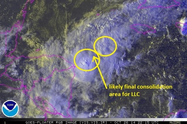
There looks to be 2 centers that have formed. The northern one is weaker and starting to give up its energy to the southern one. I drew an arrow where I think they'll soon consolidate, though the southern one could wind up totally dominating and become the true center soon anyway. If you look at the RGB satellite loop you can see some of the low clouds on the east side are still getting pulled up into the northern circulation but that should stop as they consolidate.

Image
0 likes   

Sanibel
Category 5
Category 5
Posts: 10375
Joined: Mon Aug 30, 2004 11:06 pm
Location: Offshore SW Florida

Re: ATL: INVEST 94L - Discussion

#687 Postby Sanibel » Sun Oct 26, 2014 6:07 pm

Just needs the engine to kick on and it could really become this year's crow server...


(By the way, this is the front-compressed southern Caribbean October "juice" I was talking about - maybe-)
Last edited by Sanibel on Sun Oct 26, 2014 6:11 pm, edited 2 times in total.
0 likes   

User avatar
cycloneye
Admin
Admin
Posts: 145274
Age: 68
Joined: Thu Oct 10, 2002 10:54 am
Location: San Juan, Puerto Rico

Re: ATL: INVEST 94L - Discussion

#688 Postby cycloneye » Sun Oct 26, 2014 6:38 pm

TROPICAL WEATHER OUTLOOK
NWS NATIONAL HURRICANE CENTER MIAMI FL
800 PM EDT SUN OCT 26 2014

For the North Atlantic...Caribbean Sea and the Gulf of Mexico:

A small low pressure system, the remnants of Tropical Depression
Nine, is located over the western Caribbean Sea, about 50 miles east
of the Honduras-Nicaragua border. Although shower and thunderstorm
activity has increased some since earlier today, the low is forecast
to move west-southwestward or southwestward over land during the
next day or so, which should inhibit any significant development.
* Formation chance through 48 hours...low...10 percent.
* Formation chance through 5 days...low...10 percent.

$$
Forecaster Kimberlain
0 likes   
Visit the Caribbean-Central America Weather Thread where you can find at first post web cams,radars
and observations from Caribbean basin members Click Here

ozonepete
Professional-Met
Professional-Met
Posts: 4743
Joined: Mon Sep 07, 2009 3:23 pm
Location: From Ozone Park, NYC / Now in Brooklyn, NY

Re: ATL: INVEST 94L - Discussion

#689 Postby ozonepete » Sun Oct 26, 2014 6:44 pm

cycloneye wrote:TROPICAL WEATHER OUTLOOK
NWS NATIONAL HURRICANE CENTER MIAMI FL
800 PM EDT SUN OCT 26 2014

For the North Atlantic...Caribbean Sea and the Gulf of Mexico:

A small low pressure system, the remnants of Tropical Depression
Nine, is located over the western Caribbean Sea, about 50 miles east
of the Honduras-Nicaragua border. Although shower and thunderstorm
activity has increased some since earlier today, the low is forecast
to move west-southwestward or southwestward over land during the
next day or so, which should inhibit any significant development.
* Formation chance through 48 hours...low...10 percent.
* Formation chance through 5 days...low...10 percent.

$$
Forecaster Kimberlain


Lol, I had a feeling they might do that. Well I'll still be watching. :wink:
0 likes   

psyclone
S2K Supporter
S2K Supporter
Posts: 4762
Joined: Wed Aug 24, 2005 9:04 pm
Location: palm harbor fl

#690 Postby psyclone » Sun Oct 26, 2014 6:44 pm

Definitely looks more impressive today. the NHC gets to drop development chances due to expected land interaction. Absent that...maybe it would have finally done something.
0 likes   

User avatar
cycloneye
Admin
Admin
Posts: 145274
Age: 68
Joined: Thu Oct 10, 2002 10:54 am
Location: San Juan, Puerto Rico

Re: ATL: INVEST 94L - Discussion

#691 Postby cycloneye » Sun Oct 26, 2014 6:47 pm

What happened in the atmosphere that at 2 PM they had West to WNW and 6 hours later changed to WSW to SW? Just asking? :)
0 likes   
Visit the Caribbean-Central America Weather Thread where you can find at first post web cams,radars
and observations from Caribbean basin members Click Here

ozonepete
Professional-Met
Professional-Met
Posts: 4743
Joined: Mon Sep 07, 2009 3:23 pm
Location: From Ozone Park, NYC / Now in Brooklyn, NY

Re: ATL: INVEST 94L - Discussion

#692 Postby ozonepete » Sun Oct 26, 2014 6:53 pm

Well for one thing they are way off on the center position. It is a lot further east than "50 miles east of the border." But this is one of the few areas they haven't done well this season - getting the center location right on a developing TC. if you look back at what I drew for my center approximation that's at least 120 miles offshore. It will take 24 hours minimally to reach land at 5 mph and if it really has stalled out then it could stay there a lot longer. Of course I rarely ever disagree with their forecast and maybe Ill be the one eating the crow, lol.
0 likes   

User avatar
Hurricaneman
Category 5
Category 5
Posts: 7351
Age: 45
Joined: Tue Aug 31, 2004 3:24 pm
Location: central florida

Re: ATL: INVEST 94L - Discussion

#693 Postby Hurricaneman » Sun Oct 26, 2014 6:58 pm

It honestly looks like a tropical cyclone, but without recon we won't know

The posts in this forum are NOT official forecast and should not be used as such. They are just the opinion of the poster and may or may not be backed by sound meteorological data. They are NOT endorsed by any professional institution or storm2k.org. For official information, please refer to the NHC and NWS products
0 likes   

ozonepete
Professional-Met
Professional-Met
Posts: 4743
Joined: Mon Sep 07, 2009 3:23 pm
Location: From Ozone Park, NYC / Now in Brooklyn, NY

Re: ATL: INVEST 94L - Discussion

#694 Postby ozonepete » Sun Oct 26, 2014 6:59 pm

cycloneye wrote:What happened in the atmosphere that at 2 PM they had West to WNW and 6 hours later changed to WSW to SW? Just asking? :)


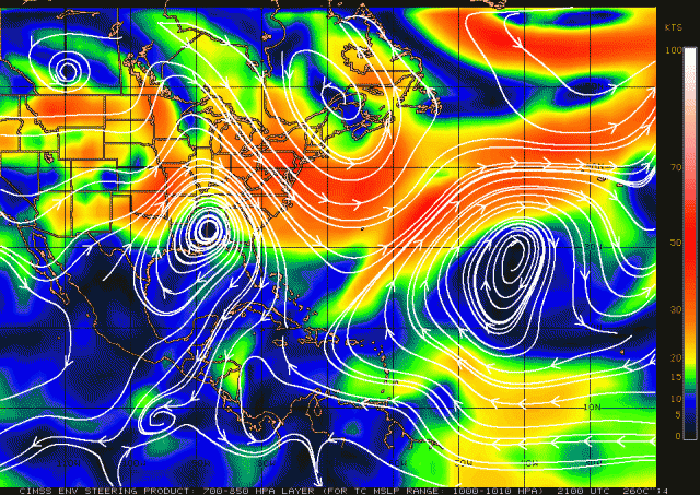
I think it's because the steering winds are very weak there and imho they are trying too hard to get the steering right by looking at the very variable local low level winds too much. From what I see, especially on the CIMSS steering winds and even GFS and euro, this disturbance is right on the edge of a calm steering area and the low to mid level steering winds just to the west of the calm area are very weak and shifting a lot. They shifted from blowing westward to blowing southwestward today. I would have described steering winds as very weak for the next 24 hours and left it at that.
0 likes   

User avatar
gatorcane
S2K Supporter
S2K Supporter
Posts: 23691
Age: 47
Joined: Sun Mar 13, 2005 3:54 pm
Location: Boca Raton, FL

#695 Postby gatorcane » Sun Oct 26, 2014 7:02 pm

I would have gone with 30-40% in the next 24 hours due to better SAT imagery presentation and low-level vorticity charts + the chance it doesn't move ashore as quickly as the models think. Basically all the models are bringing it W or WSW in the next 24 hours now and show no development whereas 12 hours ago many were going north along the coast of Honduras with a couple of models showing development. I think the NHC forecast reflects the model consensus.

The posts in this forum are NOT official forecast and should not be used as such. They are just the opinion of the poster and may or may not be backed by sound meteorological data. They are NOT endorsed by any professional institution or storm2k.org. For official information, please refer to the NHC and NWS products.
0 likes   

Dean4Storms
S2K Supporter
S2K Supporter
Posts: 6358
Age: 62
Joined: Sun Aug 31, 2003 1:01 pm
Location: Miramar Bch. FL

#696 Postby Dean4Storms » Sun Oct 26, 2014 7:11 pm

Looks impressive this evening but just doesn't have much time, this season has been like this!
0 likes   

User avatar
Hurricaneman
Category 5
Category 5
Posts: 7351
Age: 45
Joined: Tue Aug 31, 2004 3:24 pm
Location: central florida

#697 Postby Hurricaneman » Sun Oct 26, 2014 7:15 pm

I don't think the models have any idea where this is going, we just have to wait for this to make its move

The posts in this forum are NOT official forecast and should not be used as such. They are just the opinion of the poster and may or may not be backed by sound meteorological data. They are NOT endorsed by any professional institution or storm2k.org. For official information, please refer to the NHC and NWS products
0 likes   

ozonepete
Professional-Met
Professional-Met
Posts: 4743
Joined: Mon Sep 07, 2009 3:23 pm
Location: From Ozone Park, NYC / Now in Brooklyn, NY

Re:

#698 Postby ozonepete » Sun Oct 26, 2014 7:18 pm

Dean4Storms wrote:Looks impressive this evening but just doesn't have much time, this season has been like this!


Lol, yeah Dean it's another squeaker. Look at the current steering winds for weak storms. There are none at all right over this right now and should it drift west tonight they should actually push it south and keep it offshore. That's why I'm not in a rush to call game over.

Image
0 likes   

User avatar
NDG
S2K Supporter
S2K Supporter
Posts: 15446
Joined: Sun Jul 09, 2006 10:14 pm
Location: Orlando, FL

Re: ATL: INVEST 94L - Discussion

#699 Postby NDG » Sun Oct 26, 2014 7:18 pm

This evening it has developed a fairly impressive stacked circulation clearly seen IR satellite loop just east of the Nica/Honduras Border:

http://wwwghcc.msfc.nasa.gov/cgi-bin/ge ... mframes=30

Make sure to speed up the loop.
0 likes   

User avatar
Hurricaneman
Category 5
Category 5
Posts: 7351
Age: 45
Joined: Tue Aug 31, 2004 3:24 pm
Location: central florida

Re: ATL: INVEST 94L - Discussion

#700 Postby Hurricaneman » Sun Oct 26, 2014 7:23 pm

The LLCC is on the NE side of the convection around 82.5W 16.5N and would need to be closer to the center of the convection to go to town so to speak. I also agree with Pete here that this is not 50mi from Houndoras but closer to 125mi so who knows what this has up its sleeve but as someone mentioned earlier in the thread the setup is similar to Hurricane Richard in 2010

The posts in this forum are NOT official forecast and should not be used as such. They are just the opinion of the poster and may or may not be backed by sound meteorological data. They are NOT endorsed by any professional institution or storm2k.org. For official information, please refer to the NHC and NWS products
0 likes   


Return to “2014”

Who is online

Users browsing this forum: No registered users and 6 guests