WPAC: HAGUPIT - Post-Tropical

Moderator: S2k Moderators

Message
Author
ozonepete
Professional-Met
Professional-Met
Posts: 4743
Joined: Mon Sep 07, 2009 3:23 pm
Location: From Ozone Park, NYC / Now in Brooklyn, NY

Re: WPAC: HAGUPIT - Typhoon

#601 Postby ozonepete » Fri Dec 05, 2014 9:00 pm

Alyono wrote:This is in no way, shape, or form, going to recurve or be steered by the low level winds.

This is going nearly due west through the Philippines, just as has been forecast for the past 4 days


Time will tell. :)
0 likes   

User avatar
xtyphooncyclonex
Category 5
Category 5
Posts: 3861
Age: 23
Joined: Sat Dec 08, 2012 9:07 am
Location: Cebu City
Contact:

Re: WPAC: HAGUPIT - Typhoon

#602 Postby xtyphooncyclonex » Fri Dec 05, 2014 9:01 pm

Alyono wrote:This is in no way, shape, or form, going to recurve or be steered by the low level winds.

This is going nearly due west through the Philippines, just as has been forecast for the past 4 days

By recurve he means it would move southwest over the Philippines.
0 likes   
REMINDER: My opinions that I, or any other NON Pro-Met in this forum, are unofficial. Please do not take my opinions as an official forecast and warning. I am NOT a meteorologist. Following my forecasts blindly may lead to false alarm, danger and risk if official forecasts from agencies are ignored.

dexterlabio
Category 5
Category 5
Posts: 3468
Joined: Sat Oct 24, 2009 11:50 pm

Re: WPAC: HAGUPIT - Typhoon

#603 Postby dexterlabio » Fri Dec 05, 2014 9:05 pm

xtyphooncyclonex wrote:By recurve he means it would move southwest over the Philippines.


Ozonepete meant southwesterly low-level winds...means steering winds from the southwest which might push the storm to the northeast...


Though I really really like the sharp recurve scenario to happen, I think the chance of it happening is quite slim...


Btw I am watching the local news and weather in Samar and Leyte (and even Bicol region) is quickly deteriorating. Strong wind gusts reported in Eastern Samar for the past hours.
0 likes   
Personal Forecast Disclaimer:
The posts in this forum are NOT official forecast and should not be used as such. They are just the opinion of the poster and may or may not be backed by sound meteorological data. They are NOT endorsed by any professional institution or storm2k.org. For official information, please refer to the NHC and NWS products.

User avatar
NDG
S2K Supporter
S2K Supporter
Posts: 15446
Joined: Sun Jul 09, 2006 10:14 pm
Location: Orlando, FL

Re: WPAC: HAGUPIT - Typhoon

#604 Postby NDG » Fri Dec 05, 2014 9:06 pm

Image
0 likes   

User avatar
xtyphooncyclonex
Category 5
Category 5
Posts: 3861
Age: 23
Joined: Sat Dec 08, 2012 9:07 am
Location: Cebu City
Contact:

Re: WPAC: HAGUPIT - Typhoon

#605 Postby xtyphooncyclonex » Fri Dec 05, 2014 9:06 pm

dexterlabio wrote:
xtyphooncyclonex wrote:By recurve he means it would move southwest over the Philippines.


Ozonepete meant southwesterly low-level winds...means steering winds from the southwest which might push the storm to the northeast...


Though I really really like the sharp recurve scenario to happen, I think the chance of it happening is quite slim...


Btw I am watching the local news and weather in Samar and Leyte (and even Bicol region) is quickly deteriorating. Strong wind gusts reported in Eastern Samar for the past hours.

Oh, yeah. I think that is very, very unlikely despite the fact that I really want a fishie..
0 likes   
REMINDER: My opinions that I, or any other NON Pro-Met in this forum, are unofficial. Please do not take my opinions as an official forecast and warning. I am NOT a meteorologist. Following my forecasts blindly may lead to false alarm, danger and risk if official forecasts from agencies are ignored.

ozonepete
Professional-Met
Professional-Met
Posts: 4743
Joined: Mon Sep 07, 2009 3:23 pm
Location: From Ozone Park, NYC / Now in Brooklyn, NY

Re: Re:

#606 Postby ozonepete » Fri Dec 05, 2014 9:10 pm

xtyphooncyclonex wrote:So where do you think the first landfall will be?

And how strong the winds would be in Cebu City?
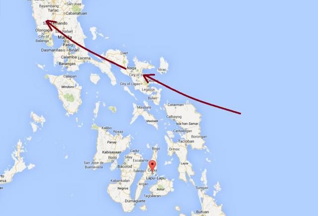

Here's the rough path I think it will take. Just my forecast, ok? Anyway, if my track holds up, and this landfalls near Tabaco, and it has a strength of roughly 80-90 knots as it passes north of you, you will get 30-40 mph sustained winds with gusts to 60 or 70 mph. If the JTWC track, which is a little south of mine and thus closer to you, holds up, then you could get 40-50 mph sustained with gusts 70-80 mph I would think.

Some forecasters here say it's going due west which is much different and I don't want to comment on their forecasts since I haven't run the numbers for those paths. They can tell you what winds they think you'll get if their forecasts hold up.

Image
0 likes   

ozonepete
Professional-Met
Professional-Met
Posts: 4743
Joined: Mon Sep 07, 2009 3:23 pm
Location: From Ozone Park, NYC / Now in Brooklyn, NY

Re: WPAC: HAGUPIT - Typhoon

#607 Postby ozonepete » Fri Dec 05, 2014 9:13 pm

dexterlabio wrote:
xtyphooncyclonex wrote:By recurve he means it would move southwest over the Philippines.


Ozonepete meant southwesterly low-level winds...means steering winds from the southwest which might push the storm to the northeast...


Though I really really like the sharp recurve scenario to happen, I think the chance of it happening is quite slim...


Btw I am watching the local news and weather in Samar and Leyte (and even Bicol region) is quickly deteriorating. Strong wind gusts reported in Eastern Samar for the past hours.


Yes that's what I meant. :) And yes it is not likely. Just something we would love to see happen.
0 likes   

User avatar
NDG
S2K Supporter
S2K Supporter
Posts: 15446
Joined: Sun Jul 09, 2006 10:14 pm
Location: Orlando, FL

#608 Postby NDG » Fri Dec 05, 2014 9:13 pm

Image
0 likes   

dexterlabio
Category 5
Category 5
Posts: 3468
Joined: Sat Oct 24, 2009 11:50 pm

#609 Postby dexterlabio » Fri Dec 05, 2014 9:24 pm

At this rate, this could be just as strong (or a bit stronger) as Rammasun when it hit the Philippines.
0 likes   
Personal Forecast Disclaimer:
The posts in this forum are NOT official forecast and should not be used as such. They are just the opinion of the poster and may or may not be backed by sound meteorological data. They are NOT endorsed by any professional institution or storm2k.org. For official information, please refer to the NHC and NWS products.

oaba09
S2K Supporter
S2K Supporter
Posts: 1496
Age: 38
Joined: Thu Oct 01, 2009 10:02 am
Location: Valenzuela, Philippines
Contact:

Re:

#610 Postby oaba09 » Fri Dec 05, 2014 9:35 pm

dexterlabio wrote:At this rate, this could be just as strong (or a bit stronger) as Rammasun when it hit the Philippines.


JTWC's latest track actually reminds me of ranmasun......
0 likes   

ozonepete
Professional-Met
Professional-Met
Posts: 4743
Joined: Mon Sep 07, 2009 3:23 pm
Location: From Ozone Park, NYC / Now in Brooklyn, NY

Re: Re:

#611 Postby ozonepete » Fri Dec 05, 2014 9:40 pm

oaba09 wrote:
dexterlabio wrote:At this rate, this could be just as strong (or a bit stronger) as Rammasun when it hit the Philippines.


JTWC's latest track actually reminds me of ranmasun......


Sure seems like it's going very close to Manila...
0 likes   

oaba09
S2K Supporter
S2K Supporter
Posts: 1496
Age: 38
Joined: Thu Oct 01, 2009 10:02 am
Location: Valenzuela, Philippines
Contact:

Re: Re:

#612 Postby oaba09 » Fri Dec 05, 2014 9:49 pm

ozonepete wrote:
oaba09 wrote:
dexterlabio wrote:At this rate, this could be just as strong (or a bit stronger) as Rammasun when it hit the Philippines.


JTWC's latest track actually reminds me of ranmasun......


Sure seems like it's going very close to Manila...


What do you think can cause the more polewards track that JTWC is forecasting?
JMA seems to still be sticking with their westwards track.
0 likes   

User avatar
gatorcane
S2K Supporter
S2K Supporter
Posts: 23691
Age: 47
Joined: Sun Mar 13, 2005 3:54 pm
Location: Boca Raton, FL

#613 Postby gatorcane » Fri Dec 05, 2014 9:49 pm

Looks to be moving west, maybe even hinting at a hair south of west:

Image
0 likes   

User avatar
NDG
S2K Supporter
S2K Supporter
Posts: 15446
Joined: Sun Jul 09, 2006 10:14 pm
Location: Orlando, FL

#614 Postby NDG » Fri Dec 05, 2014 9:52 pm

It seems to me that during the past several hours it has been on an almost due west heading.
0 likes   

dexterlabio
Category 5
Category 5
Posts: 3468
Joined: Sat Oct 24, 2009 11:50 pm

Re: WPAC: HAGUPIT - Typhoon

#615 Postby dexterlabio » Fri Dec 05, 2014 9:55 pm

Yeah, due west for the past 6 hours...and the last few frames indicate a south of west movement.
0 likes   
Personal Forecast Disclaimer:
The posts in this forum are NOT official forecast and should not be used as such. They are just the opinion of the poster and may or may not be backed by sound meteorological data. They are NOT endorsed by any professional institution or storm2k.org. For official information, please refer to the NHC and NWS products.

dexterlabio
Category 5
Category 5
Posts: 3468
Joined: Sat Oct 24, 2009 11:50 pm

#616 Postby dexterlabio » Fri Dec 05, 2014 9:57 pm

PAGASA forecast has Hagupit making landfall tomorrow morning (Manila time) in Samar....well this is moving at a snail's pace but it looks like it's picking up speed to make it in the evening...
0 likes   
Personal Forecast Disclaimer:
The posts in this forum are NOT official forecast and should not be used as such. They are just the opinion of the poster and may or may not be backed by sound meteorological data. They are NOT endorsed by any professional institution or storm2k.org. For official information, please refer to the NHC and NWS products.

ozonepete
Professional-Met
Professional-Met
Posts: 4743
Joined: Mon Sep 07, 2009 3:23 pm
Location: From Ozone Park, NYC / Now in Brooklyn, NY

Re: WPAC: HAGUPIT - Typhoon

#617 Postby ozonepete » Fri Dec 05, 2014 10:01 pm

Some recent quotes from here:

"Looks to be moving west, maybe even hinting at a hair south of west:"

"It seems to me that during the past several hours it has been on an almost due west heading."

"Yeah, due west for the past 6 hours...and the last few frames indicate a south of west movement."


Wobble watching, lol.
0 likes   

User avatar
xtyphooncyclonex
Category 5
Category 5
Posts: 3861
Age: 23
Joined: Sat Dec 08, 2012 9:07 am
Location: Cebu City
Contact:

Re: WPAC: HAGUPIT - Typhoon

#618 Postby xtyphooncyclonex » Fri Dec 05, 2014 10:04 pm

ozonepete wrote:Some recent quotes from here:

"Looks to be moving west, maybe even hinting at a hair south of west:"

"It seems to me that during the past several hours it has been on an almost due west heading."

"Yeah, due west for the past 6 hours...and the last few frames indicate a south of west movement."


Wobble watching, lol.

Not wobble watching, that's what JMA, ECMWF and GFS consistently showing since yesterday.
0 likes   
REMINDER: My opinions that I, or any other NON Pro-Met in this forum, are unofficial. Please do not take my opinions as an official forecast and warning. I am NOT a meteorologist. Following my forecasts blindly may lead to false alarm, danger and risk if official forecasts from agencies are ignored.

ozonepete
Professional-Met
Professional-Met
Posts: 4743
Joined: Mon Sep 07, 2009 3:23 pm
Location: From Ozone Park, NYC / Now in Brooklyn, NY

Re: Re:

#619 Postby ozonepete » Fri Dec 05, 2014 10:07 pm

oaba09 wrote:
ozonepete wrote:
Sure seems like it's going very close to Manila...


What do you think can cause the more polewards track that JTWC is forecasting?
JMA seems to still be sticking with their westwards track.


JMA and JTWC have completely separate staffs that have some different ideas about how to forecast typhoons. That's healthy imho. The difference between their tracks isn't that great so it doesn't bother me personally. But I think that the reason JMA is sticking to an almost pure westward track is probably because they like the "KING EURO NAIL" better than JTWC does. :wink:
0 likes   

ozonepete
Professional-Met
Professional-Met
Posts: 4743
Joined: Mon Sep 07, 2009 3:23 pm
Location: From Ozone Park, NYC / Now in Brooklyn, NY

Re: WPAC: HAGUPIT - Typhoon

#620 Postby ozonepete » Fri Dec 05, 2014 10:10 pm

xtyphooncyclonex wrote:
ozonepete wrote:Some recent quotes from here:

"Looks to be moving west, maybe even hinting at a hair south of west:"

"It seems to me that during the past several hours it has been on an almost due west heading."

"Yeah, due west for the past 6 hours...and the last few frames indicate a south of west movement."


Wobble watching, lol.

Not wobble watching, that's what JMA, ECMWF and GFS consistently showing since yesterday.


That wasn't meant to be negative. It refers to how we watch so closely that every wobble in the forward direction seems to indicate the proper direction. It is a friendly joke among all of here on Storm2k. Not meant to be frivolous. I am wobble watching too. And love it.
0 likes   


Return to “2014”

Who is online

Users browsing this forum: No registered users and 2 guests