


EPAC: AMANDA - Post-Tropical
Moderator: S2k Moderators
Re: EPAC: AMANDA - Hurricane
Latest visible loop. So glad we got something (out of harms way) to track this early. Very majestic.
Last edited by Ntxw on Sun May 25, 2014 9:56 am, edited 1 time in total.
0 likes
The above post and any post by Ntxw is NOT an official forecast and should not be used as such. It is just the opinion of the poster and may or may not be backed by sound meteorological data. It is NOT endorsed by any professional institution including Storm2k. For official information, please refer to NWS products.
Help support Storm2K!

-
tolakram
- Admin

- Posts: 20186
- Age: 62
- Joined: Sun Aug 27, 2006 8:23 pm
- Location: Florence, KY (name is Mark)
Re: EPAC: AMANDA - Hurricane
14:30Z


0 likes
M a r k
- - - - -
Join us in chat: Storm2K Chatroom Invite. Android and IOS apps also available.
The posts in this forum are NOT official forecasts and should not be used as such. Posts are NOT endorsed by any professional institution or STORM2K.org. For official information and forecasts, please refer to NHC and NWS products.
-
Yellow Evan

- Professional-Met

- Posts: 16242
- Age: 27
- Joined: Fri Jul 15, 2011 12:48 pm
- Location: Henderson, Nevada/Honolulu, HI
- Contact:
-
hurricanes1234
- Category 5

- Posts: 2908
- Joined: Sat Jul 28, 2012 6:19 pm
- Location: Trinidad and Tobago
Re:
Yellow Evan wrote:Still no advisory. 4 more mins and they are late.
They are probably deciding on whether to keep it a Category 4 or upgrade it to a Category 5. If it gets upgraded, this will be my first ever Category 5 I've tracked.
0 likes
PLEASE NOTE: With the exception of information from weather agencies that I may copy and paste here, my posts will NEVER be official, since I am NOT a meteorologist. They are solely my amateur opinion, and may or may not be accurate. Therefore, please DO NOT use them as official details, particularly when making important decisions. Thank you.
-
hurricanes1234
- Category 5
- Posts: 2908
- Joined: Sat Jul 28, 2012 6:19 pm
- Location: Trinidad and Tobago
Aww, it didn't make it to Category 5. But still a very impressive storm nonetheless. It's the second strongest I've tracked, behind Dora of 2011.
Last edited by hurricanes1234 on Sun May 25, 2014 10:02 am, edited 1 time in total.
0 likes
PLEASE NOTE: With the exception of information from weather agencies that I may copy and paste here, my posts will NEVER be official, since I am NOT a meteorologist. They are solely my amateur opinion, and may or may not be accurate. Therefore, please DO NOT use them as official details, particularly when making important decisions. Thank you.
-
xtyphooncyclonex

- Category 5
- Posts: 3892
- Age: 24
- Joined: Sat Dec 08, 2012 9:07 am
- Location: Cebu City
- Contact:
Re: Re:
Yellow Evan wrote:xtyphooncyclonex wrote:Yellow Evan wrote:Another fact: This is stronger than any storm in the NHEM since Hiayan.
Ita had a slightly lower pressure. But anyway, this has a chance to be stronger than that, even by the winds.
Ita was SHEM though.
Oh I didn't notice that.
Back to the topic.
Some warming Southeast and South of California may have contributed the intensification of Amanda. Right now, its shape and structure is just the most impressive I have tracked since typhoon Haiyan last year. Not surprised to see a category 5.
0 likes
REMINDER: My opinions that I, or any other NON Pro-Met in this forum, are unofficial. Please do not take my opinions as an official forecast and warning. I am NOT a meteorologist. Following my forecasts blindly may lead to false alarm, danger and risk if official forecasts from agencies are ignored.
-
cycloneye

- Admin
- Posts: 149550
- Age: 69
- Joined: Thu Oct 10, 2002 10:54 am
- Location: San Juan, Puerto Rico
Re: EPAC: AMANDA - Hurricane
The last paragrafh is historic.
Amanda is now the strongest May hurricane on record in the eastern
Pacific basin during the satellite era. If Amanda were to reach an
intensity of 140 kt, it would become the earliest category 5
hurricane on record, beating out Hurricane Ava of 1973.
Amanda is now the strongest May hurricane on record in the eastern
Pacific basin during the satellite era. If Amanda were to reach an
intensity of 140 kt, it would become the earliest category 5
hurricane on record, beating out Hurricane Ava of 1973.
0 likes
Visit the Caribbean-Central America Weather Thread where you can find at first post web cams,radars
and observations from Caribbean basin members Click Here
and observations from Caribbean basin members Click Here
-
Yellow Evan
- Professional-Met
- Posts: 16242
- Age: 27
- Joined: Fri Jul 15, 2011 12:48 pm
- Location: Henderson, Nevada/Honolulu, HI
- Contact:
WTPZ41 KNHC 251458
TCDEP1
HURRICANE AMANDA DISCUSSION NUMBER 12
NWS NATIONAL HURRICANE CENTER MIAMI FL EP012014
800 AM PDT SUN MAY 25 2014
Amanda has continued to rapidly strengthen this morning, although
the hurricane is likely near its peak intensity. The 15 n mi
diameter eye remains quite distinct in infrared and first-light
visible satellite imagery, and a solid ring of cloud tops as cold
as -75C surround the eye. Subjective classifications at 1200 UTC
from TAFB and SAB were T7.0/140 kt and T6.5/127 kt, respectively.
The ADT estimate from UW-CIMSS was T6.6/130 kt, and those values
have continued to steadily increase to T6.8/135 kt as of 1330 UTC.
A blend of these intensity estimates easily support increasing the
intensity to 135 kt, which is just below category 5 strength on the
Saffir-Simpson Hurricane Wind Scale.
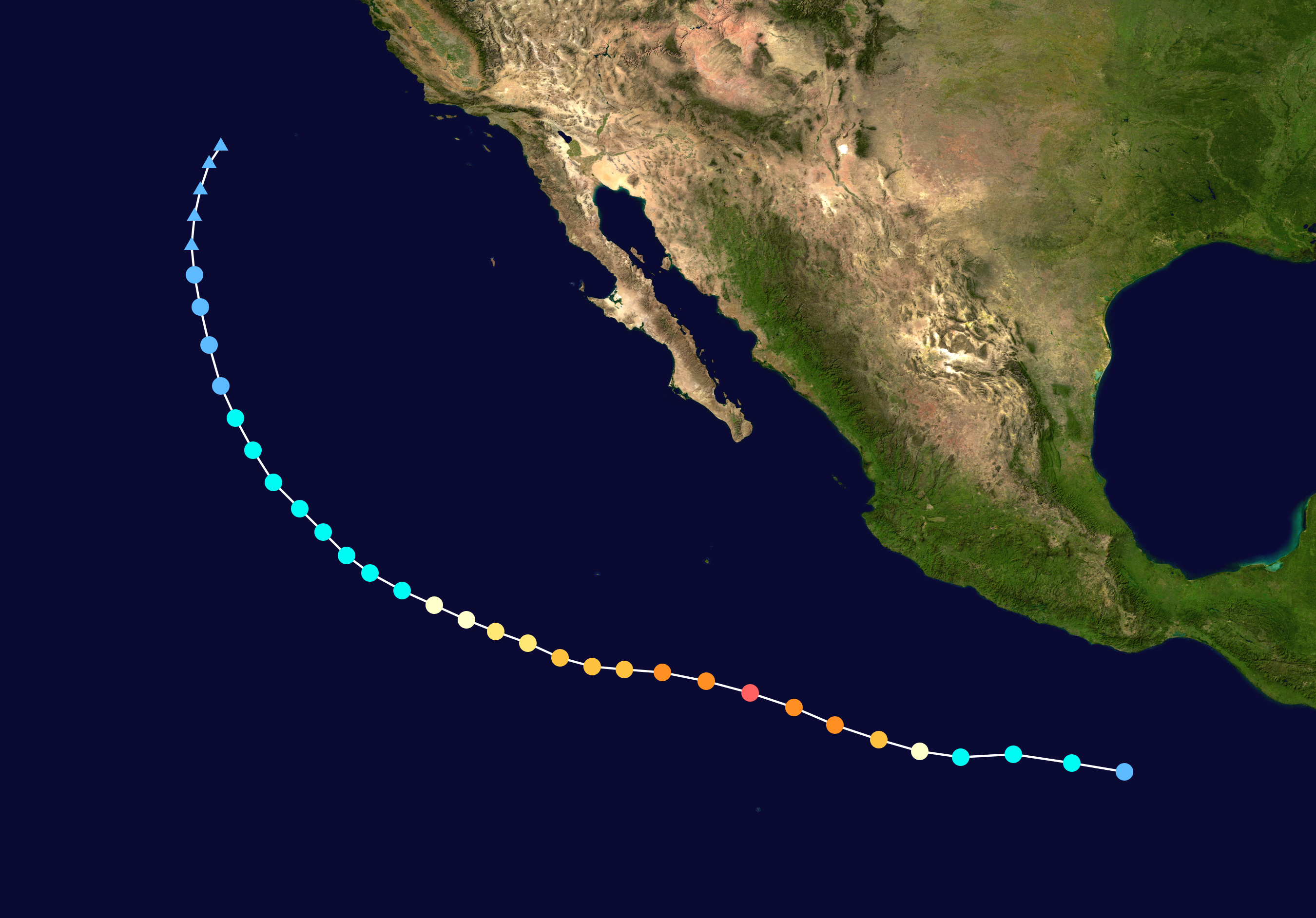
Amanda appears to have stalled during the past few hours and is now
drifting slowly northward or north-northwestward at around 2 kt, a
motion that has been well forecast in previous advisories over the
past 2 days. Amanda is expected to maintain a general northward
motion over the next 72 hours as the hurricane moves into a
combined southerly steering between a mid-/upper-level trough to its
west and a mid-level ridge to its east. By days 4 and 5, Amanda is
expected to be a significantly weakened and more shallow cyclone
that is forecast to slow down and turn westward under the influence
of a large low-level subtropical ridge located from Baja California
westward into the central Pacific Ocean. The NHC track forecast is
similar to the previous advisory and lies near a blend of the FSSE
and TVCE models.
Amanda has likely reached its peak intensity, or is very close to
it. Although the SHIPS intensity model indicates SSTs warmer than
29C exists beneath and ahead of the hurricane, various SST analysis
products at 1200 UTC this morning indicate that cold upwelling has
already begun beneath the cyclone, and this cold upwelling should be
exacerbated even further now the cyclone is moving at a forward
speed of only 2 kt. As a result, steady weakening is expected within
the next 12 hours or so. By 36 hours and beyond, southerly to
southwesterly winds shear is forecast to increase to more than 20
kt, which should further enhance the weakening process. By day 5,
the global models are in good agreement on the low- and upper-level
circulations decoupling, which could result in Amanda becoming a
remnant low at that time. The official intensity forecast is similar
to the previous advisory, and closely follows the intensity model
consensus IVCN, which is well below the SHIPS and LGEM models
through 36 hours.
Amanda is now the strongest May hurricane on record in the eastern
Pacific basin during the satellite era. If Amanda were to reach an
intensity of 140 kt, it would become the earliest category 5
hurricane on record, beating out Hurricane Ava of 1973.
FORECAST POSITIONS AND MAX WINDS
INIT 25/1500Z 11.8N 111.1W 135 KT 155 MPH
12H 26/0000Z 12.2N 111.3W 130 KT 150 MPH
24H 26/1200Z 13.0N 111.4W 120 KT 140 MPH
36H 27/0000Z 14.0N 111.6W 105 KT 120 MPH
48H 27/1200Z 15.0N 111.7W 90 KT 105 MPH
72H 28/1200Z 16.5N 111.5W 65 KT 75 MPH
96H 29/1200Z 17.6N 110.7W 45 KT 50 MPH
120H 30/1200Z 18.6N 110.0W 30 KT 35 MPH
$$
Forecaster Stewart
TCDEP1
HURRICANE AMANDA DISCUSSION NUMBER 12
NWS NATIONAL HURRICANE CENTER MIAMI FL EP012014
800 AM PDT SUN MAY 25 2014
Amanda has continued to rapidly strengthen this morning, although
the hurricane is likely near its peak intensity. The 15 n mi
diameter eye remains quite distinct in infrared and first-light
visible satellite imagery, and a solid ring of cloud tops as cold
as -75C surround the eye. Subjective classifications at 1200 UTC
from TAFB and SAB were T7.0/140 kt and T6.5/127 kt, respectively.
The ADT estimate from UW-CIMSS was T6.6/130 kt, and those values
have continued to steadily increase to T6.8/135 kt as of 1330 UTC.
A blend of these intensity estimates easily support increasing the
intensity to 135 kt, which is just below category 5 strength on the
Saffir-Simpson Hurricane Wind Scale.
Amanda appears to have stalled during the past few hours and is now
drifting slowly northward or north-northwestward at around 2 kt, a
motion that has been well forecast in previous advisories over the
past 2 days. Amanda is expected to maintain a general northward
motion over the next 72 hours as the hurricane moves into a
combined southerly steering between a mid-/upper-level trough to its
west and a mid-level ridge to its east. By days 4 and 5, Amanda is
expected to be a significantly weakened and more shallow cyclone
that is forecast to slow down and turn westward under the influence
of a large low-level subtropical ridge located from Baja California
westward into the central Pacific Ocean. The NHC track forecast is
similar to the previous advisory and lies near a blend of the FSSE
and TVCE models.
Amanda has likely reached its peak intensity, or is very close to
it. Although the SHIPS intensity model indicates SSTs warmer than
29C exists beneath and ahead of the hurricane, various SST analysis
products at 1200 UTC this morning indicate that cold upwelling has
already begun beneath the cyclone, and this cold upwelling should be
exacerbated even further now the cyclone is moving at a forward
speed of only 2 kt. As a result, steady weakening is expected within
the next 12 hours or so. By 36 hours and beyond, southerly to
southwesterly winds shear is forecast to increase to more than 20
kt, which should further enhance the weakening process. By day 5,
the global models are in good agreement on the low- and upper-level
circulations decoupling, which could result in Amanda becoming a
remnant low at that time. The official intensity forecast is similar
to the previous advisory, and closely follows the intensity model
consensus IVCN, which is well below the SHIPS and LGEM models
through 36 hours.
Amanda is now the strongest May hurricane on record in the eastern
Pacific basin during the satellite era. If Amanda were to reach an
intensity of 140 kt, it would become the earliest category 5
hurricane on record, beating out Hurricane Ava of 1973.
FORECAST POSITIONS AND MAX WINDS
INIT 25/1500Z 11.8N 111.1W 135 KT 155 MPH
12H 26/0000Z 12.2N 111.3W 130 KT 150 MPH
24H 26/1200Z 13.0N 111.4W 120 KT 140 MPH
36H 27/0000Z 14.0N 111.6W 105 KT 120 MPH
48H 27/1200Z 15.0N 111.7W 90 KT 105 MPH
72H 28/1200Z 16.5N 111.5W 65 KT 75 MPH
96H 29/1200Z 17.6N 110.7W 45 KT 50 MPH
120H 30/1200Z 18.6N 110.0W 30 KT 35 MPH
$$
Forecaster Stewart
0 likes
-
xtyphooncyclonex
- Category 5
- Posts: 3892
- Age: 24
- Joined: Sat Dec 08, 2012 9:07 am
- Location: Cebu City
- Contact:
Amazing, and shocking Hurricane Amanda.
The TWO:
Amanda is now the strongest May hurricane on record in the eastern
Pacific basin during the satellite era. If Amanda were to reach an
intensity of 140 kt, it would become the earliest category 5
hurricane on record, beating out Hurricane Ava of 1973.
The TWO:
Amanda is now the strongest May hurricane on record in the eastern
Pacific basin during the satellite era. If Amanda were to reach an
intensity of 140 kt, it would become the earliest category 5
hurricane on record, beating out Hurricane Ava of 1973.
0 likes
REMINDER: My opinions that I, or any other NON Pro-Met in this forum, are unofficial. Please do not take my opinions as an official forecast and warning. I am NOT a meteorologist. Following my forecasts blindly may lead to false alarm, danger and risk if official forecasts from agencies are ignored.
-
Yellow Evan
- Professional-Met
- Posts: 16242
- Age: 27
- Joined: Fri Jul 15, 2011 12:48 pm
- Location: Henderson, Nevada/Honolulu, HI
- Contact:
-
xtyphooncyclonex
- Category 5
- Posts: 3892
- Age: 24
- Joined: Sat Dec 08, 2012 9:07 am
- Location: Cebu City
- Contact:
Re: Re:
hurricanes1234 wrote:Yellow Evan wrote:Still no advisory. 4 more mins and they are late.
They are probably deciding on whether to keep it a Category 4 or upgrade it to a Category 5. If it gets upgraded, this will be my first ever Category 5 I've tracked.
You have also tracked Haiyan, and other WPac category 5 typhoons.
To specify, this is may become the first category 5 IN THE EPAC that you have ever tracked, and also the first ePac category 4 I have ever tracked, because I usually track in the WPac. This is the most impressive and earliest forming ePac system I have ever encountered (since I have joined s2k) and this is something that is historic.
0 likes
REMINDER: My opinions that I, or any other NON Pro-Met in this forum, are unofficial. Please do not take my opinions as an official forecast and warning. I am NOT a meteorologist. Following my forecasts blindly may lead to false alarm, danger and risk if official forecasts from agencies are ignored.

-
Yellow Evan
- Professional-Met
- Posts: 16242
- Age: 27
- Joined: Fri Jul 15, 2011 12:48 pm
- Location: Henderson, Nevada/Honolulu, HI
- Contact:
The RI of the storm really on matches one other storm:
https://en.wikipedia.org/wiki/Hurricane ... %282002%29
Interestingly enough, that was a Cat 4 real time, but upgraded in the TCR.
https://en.wikipedia.org/wiki/Hurricane ... %282002%29
Interestingly enough, that was a Cat 4 real time, but upgraded in the TCR.
0 likes
-
mrbagyo

- Category 5
- Posts: 3963
- Age: 33
- Joined: Thu Apr 12, 2012 9:18 am
- Location: 14.13N 120.98E
- Contact:
Re: EPAC: AMANDA - Hurricane
Meow wrote:Yellow Evan wrote:Another fact: This is stronger than any storm in the NHEM since Hiayan.
That should be ‘Haiyan’. Here is the comparison of Amanda and Haiyan.
Amanda suddenly gets humbled. hahaha... every storm will be humbled if compared with Haiyan.
0 likes
The posts in this forum are NOT official forecast and should not be used as such. They are just the opinion of the poster and may or may not be backed by sound meteorological data. They are NOT endorsed by any professional institution or storm2k.org. For official information, please refer to RSMC, NHC and NWS products.
-
Yellow Evan
- Professional-Met
- Posts: 16242
- Age: 27
- Joined: Fri Jul 15, 2011 12:48 pm
- Location: Henderson, Nevada/Honolulu, HI
- Contact:
Re: EPAC: AMANDA - Hurricane
mrbagyo wrote:Meow wrote:Yellow Evan wrote:Another fact: This is stronger than any storm in the NHEM since Hiayan.
That should be ‘Haiyan’. Here is the comparison of Amanda and Haiyan.
Amanda suddenly gets humbled. hahaha... every storm will be humbled if compared with Haiyan.
I think it's better to compared to other 135 knot storms like Jimena 09 or Dora 11.
0 likes
-
Yellow Evan
- Professional-Met
- Posts: 16242
- Age: 27
- Joined: Fri Jul 15, 2011 12:48 pm
- Location: Henderson, Nevada/Honolulu, HI
- Contact:

-
mrbagyo
- Category 5
- Posts: 3963
- Age: 33
- Joined: Thu Apr 12, 2012 9:18 am
- Location: 14.13N 120.98E
- Contact:
Re: EPAC: AMANDA - Hurricane
Yellow Evan wrote:I think it's better to compared to other 135 knot storms like Jimena 09 or Dora 11.
yeah. that's a better comparison.
0 likes
The posts in this forum are NOT official forecast and should not be used as such. They are just the opinion of the poster and may or may not be backed by sound meteorological data. They are NOT endorsed by any professional institution or storm2k.org. For official information, please refer to RSMC, NHC and NWS products.
-
Meow

-
Yellow Evan
- Professional-Met
- Posts: 16242
- Age: 27
- Joined: Fri Jul 15, 2011 12:48 pm
- Location: Henderson, Nevada/Honolulu, HI
- Contact:
Re:
Meow wrote:Here’s the comparison of Amanda in 2014 and Dora in 2011, the same intensity and basin.
I prefer Amanda, however.
They are similar; Dora is larger, but Amanda looks a little better IMO.
0 likes
-
Yellow Evan
- Professional-Met
- Posts: 16242
- Age: 27
- Joined: Fri Jul 15, 2011 12:48 pm
- Location: Henderson, Nevada/Honolulu, HI
- Contact:
Who is online
Users browsing this forum: No registered users and 17 guests