ATL: DOLLY - REMNANTS - Discussion

Moderator: S2k Moderators

Message
Author
User avatar
beoumont
Category 1
Category 1
Posts: 473
Joined: Sun Jul 10, 2011 4:13 pm
Location: East Central Florida
Contact:

Re: ATL: INVEST 99L - Discussion

#261 Postby beoumont » Mon Sep 01, 2014 1:51 am

Something's happening here:

Image

What it is ain't exactly clear:

Image
Last edited by beoumont on Mon Sep 01, 2014 4:38 am, edited 3 times in total.
0 likes   
List of 79 tropical cyclones intercepted by Richard Horodner:
http://www.canebeard.com/page/page/572246.htm

Alyono
Professional-Met
Professional-Met
Posts: 6961
Joined: Fri Apr 26, 2013 3:52 pm
Location: Texas Coast

#262 Postby Alyono » Mon Sep 01, 2014 2:43 am

the surface feature may be closer to 91W
0 likes   

User avatar
Hammy
Category 5
Category 5
Posts: 5849
Age: 41
Joined: Fri May 25, 2012 5:25 pm
Contact:

#263 Postby Hammy » Mon Sep 01, 2014 4:11 am

rotation looks to be about 93-94 and at the speed it's moving likely inland within 24 hours; I have a feeling the recon mission is going to be cancelled once the sun comes up.
0 likes   
The above post is not official and should not be used as such. It is the opinion of the poster and may or may not be backed by sound meteorological data. It is not endorsed by any professional institution or storm2k.org. For official information, please refer to the NHC and NWS products.

User avatar
cycloneye
Admin
Admin
Posts: 145295
Age: 68
Joined: Thu Oct 10, 2002 10:54 am
Location: San Juan, Puerto Rico

Re: ATL: INVEST 99L - Discussion

#264 Postby cycloneye » Mon Sep 01, 2014 6:10 am

The Brownsville NWS made a good discussion about how 99L/TD?/TS? may increase the moisture for South Texas.

.LONG TERM.../TUESDAY NIGHT THROUGH SUNDAY/...THE MAIN CONCERN IN
THE LONGER RANGE PERIOD WILL BE THE EVENTUAL TRACK AND DESTINATION
OF THE SURFACE LOW NOW EMERGING OFF OF THE YUCATAN PENINSULA
HEADING TO THE WEST NORTHWEST PUSHING ACROSS THE SOUTHWESTERN
GULF OF MEX. THE BULK OF THE LONGER RANGE MODEL GUIDANCE WANTS TO
KEEP THIS FEATURE ON A GENERAL WEST NORTHWEST TRACK WITH THE
CENTER MOVING INLAND ROUGHLY NEAR THE TAMPICO AREA TUES
NIGHT/EARLY WEDNESDAY MORNING. THIS WEST NORTHWEST MOVEMENT IS
MAINTAINED THROUGH THE NEXT COUPLE OF DAYS AS BROAD 500 MB RIDGING
BUILDS OVER THE SOUTHERN STATES. IF THIS SURFACE LOW REMAINS
FAIRLY BROADLY ORGANIZED WITH A LARGE SWATH OF DEEPER LAYER TROPICAL
MOISTURE ASSOCIATED WITH IT THEN A FAIRLY BROAD AREA OF TROPICAL
RAINS WILL LIKELY SPREAD ACROSS DEEP SOUTH TX AND NORTHEASTERN
MEXICO RESULTING IN MORE WIDESPREAD RAINFALL TOTALS. IF THE SYSTEM
BECOMES BETTER ORGANIZED AS IT TRACKS ACROSS THE SOUTHWESTERN
GULF THEN THE BULK OF THE PCPN MAY BE MORE CONCENTRATED FURTHER
SOUTH WHICH WOULD MISS MUCH OF THE RGV. AT THIS TIME AM GOING WITH
THE SCENARIO WITH A MORE BROADLY DEFINED SURFACE LOW/TROUGH WHICH
WOULD RESULT IN BETTER CONV CHCS FOR THE REGION.

THE ECMWF AND GFS POPS ARE FAIRLY SIMILAR IN INCREASING POPS TUES
NIGHT THROUGH THURS AS THE TROPICAL MOISTURE ASSOCIATED WITH THE
BROAD SURFACE LOW SURGES WEST AND NORTHWEST OVER THE REGION
THROUGH MID WEEK. THE DEEPER LAYER MOISTURE VALUES START TO
DIMINISH GRADUALLY OVER THE AREA AS THE WEEKEND APPROACHES AND
WILL GRADUALLY TREND DOWN THE CONV CHCS INTO NEXT SATURDAY AND
SUNDAY AS THE DEEP LAYER TROPICAL MOISTURE FEED SHIFTS WEST AND
NORTH AROUND THE WEST SIDE OF THE SOUTHERN 500 MB RIDGE AXIS.

SINCE THE LONGER RANGE MODEL GUIDANCE IS IN PRETTY GOOD AGREEMENT
IN THE HANDLING OF THIS TROPICAL DISTURBANCE HAVE OPTED TO GO WITH
A GENERAL MODEL BLEND OF THE ECMWF AND THE GFS FOR BOTH POPS AND
TEMPS THROUGH DAY 7. THE MAX TEMPS WILL LIKELY BE SUPPRESSED A BIT
WED ADN THURS AS THE CONV CHCS MAX OUT OVER THE AREA. WILL THEN
TREND THE TEMPS UP A BIT LATER AS THE CONV CHCS FADE A BIT AND A
LITTLE MORE DIURNALY HEATING IS EXPECTED DURING THE AFTERNOON
HOURS.

OVERALL CONFIDENCE IN THE LONGER RANGE FORECAST WORDING IS ON THE
INCREASE AS THE MODEL GUIDANCE STARTS TO GEL TOWARDS A SIMILAR
SOLUTION. RUN TO RUN CONSISTENCY WITH THE GFS MEX MOS HAS ALSO
BEEN PRETTY STABLE OVER THE LAST SEVERAL RUNS KEEPING THE HIGHEST
POPS FOR WED AND THURS.
0 likes   
Visit the Caribbean-Central America Weather Thread where you can find at first post web cams,radars
and observations from Caribbean basin members Click Here

User avatar
cycloneye
Admin
Admin
Posts: 145295
Age: 68
Joined: Thu Oct 10, 2002 10:54 am
Location: San Juan, Puerto Rico

Re: ATL: INVEST 99L - Discussion

#265 Postby cycloneye » Mon Sep 01, 2014 6:40 am

TROPICAL WEATHER OUTLOOK
NWS NATIONAL HURRICANE CENTER MIAMI FL
800 AM EDT MON SEP 1 2014

For the North Atlantic...Caribbean Sea and the Gulf of Mexico:

A broad area of low pressure is located over the eastern Bay
of Campeche. Environmental conditions appear to be favorable for
some development, and this system could become a tropical depression
within the next day or two as it moves west-northwestward near 10
mph. An Air Force Reserve reconnaissance aircraft is scheduled to
investigate the low this afternoon, if necessary. Regardless of
development, this system will produce heavy rainfall across the
Yucatan Peninsula and southeastern Mexico today and Tuesday, and
across portions of eastern mainland Mexico on Tuesday and Wednesday.
* Formation chance through 48 hours...high...60 percent.
* Formation chance through 5 days...high...70 percent.

$$
Forecaster Pasch
0 likes   
Visit the Caribbean-Central America Weather Thread where you can find at first post web cams,radars
and observations from Caribbean basin members Click Here

User avatar
cycloneye
Admin
Admin
Posts: 145295
Age: 68
Joined: Thu Oct 10, 2002 10:54 am
Location: San Juan, Puerto Rico

Re: ATL: INVEST 99L - Discussion

#266 Postby cycloneye » Mon Sep 01, 2014 7:45 am

12z Best Track.

AL, 99, 2014090112, , BEST, 0, 192N, 920W, 25, 1009, LO
0 likes   
Visit the Caribbean-Central America Weather Thread where you can find at first post web cams,radars
and observations from Caribbean basin members Click Here

User avatar
wxman57
Moderator-Pro Met
Moderator-Pro Met
Posts: 22978
Age: 67
Joined: Sat Jun 21, 2003 8:06 pm
Location: Houston, TX (southwest)

Re: ATL: INVEST 99L - Discussion

#267 Postby wxman57 » Mon Sep 01, 2014 8:33 am

00Z Euro remains quite consistent in taking the center inland near Tampico in just over 24 hours. GFS is much slower (like never inland). I don't trust it. Not much time for development, but should be at least a TD by noon tomorrow.
0 likes   

User avatar
cycloneye
Admin
Admin
Posts: 145295
Age: 68
Joined: Thu Oct 10, 2002 10:54 am
Location: San Juan, Puerto Rico

Re: ATL: INVEST 99L - Discussion

#268 Postby cycloneye » Mon Sep 01, 2014 8:36 am

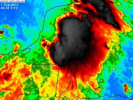
wxman57 wrote:00Z Euro remains quite consistent in taking the center inland near Tampico in just over 24 hours. Not much time for development, but should be at least a TD by noon tomorrow.


Even if it tracks to near Tampico,will the South Texas folks get plenty of rain from this?
0 likes   
Visit the Caribbean-Central America Weather Thread where you can find at first post web cams,radars
and observations from Caribbean basin members Click Here

Sanibel
Category 5
Category 5
Posts: 10375
Joined: Mon Aug 30, 2004 11:06 pm
Location: Offshore SW Florida

Re: ATL: INVEST 99L - Discussion

#269 Postby Sanibel » Mon Sep 01, 2014 8:40 am

Edit: That satellite shot is deceptive. The surface feature is offshore meaning the convection is displaced which indicates a less organized storm. In any case this is still the best organized Gulf system yet.
0 likes   

User avatar
tropicwatch
Category 5
Category 5
Posts: 3383
Age: 61
Joined: Sat Jun 02, 2007 10:01 am
Location: Panama City Florida
Contact:

Re: ATL: INVEST 99L - Discussion

#270 Postby tropicwatch » Mon Sep 01, 2014 9:07 am

0 likes   
Tropicwatch


Agnes 72', Eloise 75, Elena 85', Kate 85', Charley 86', Florence 88', Beryl 94', Dean 95', Erin 95', Opal 95', Earl 98', Georges 98', Ivan 2004', Arlene 2005', Dennis 2005', Ida 2009' Debby 2012' Irma 2017' Michael 2018'

Alyono
Professional-Met
Professional-Met
Posts: 6961
Joined: Fri Apr 26, 2013 3:52 pm
Location: Texas Coast

#271 Postby Alyono » Mon Sep 01, 2014 9:16 am

near 19.5N and 93W

convection is trying to fire near the center, but there appears to be some shear as it is being blown away quickly and we also have the suppressive Kelvin wave

conditions are marginal at best. I agree that a TD or a weak TS may form. However, highly unlikely that anything more comes from this. Again, the 1980s way of thinking favorable conditions = low shear is not the way to go. We are learning far more about what favorable conditions are. One must include planetary waves
0 likes   

User avatar
wxman57
Moderator-Pro Met
Moderator-Pro Met
Posts: 22978
Age: 67
Joined: Sat Jun 21, 2003 8:06 pm
Location: Houston, TX (southwest)

Re: ATL: INVEST 99L - Discussion

#272 Postby wxman57 » Mon Sep 01, 2014 9:49 am

I don't see anything for recon to investigate at the moment. They should cancel for today. Development is more likely going to be tonight/tomorrow.
0 likes   

User avatar
SouthDadeFish
Professional-Met
Professional-Met
Posts: 2835
Joined: Thu Sep 23, 2010 2:54 pm
Location: Miami, FL
Contact:

Re: ATL: INVEST 99L - Discussion

#273 Postby SouthDadeFish » Mon Sep 01, 2014 9:52 am

wxman57 wrote:I don't see anything for recon to investigate at the moment. They should cancel for today. Development is more likely going to be tonight/tomorrow.


I agree. Doesn't look like too much is going on at the moment.
0 likes   

hurricanehunter69
Category 1
Category 1
Posts: 343
Joined: Sun May 16, 2010 5:21 pm
Location: New Orleans

Re: ATL: INVEST 99L - Discussion

#274 Postby hurricanehunter69 » Mon Sep 01, 2014 10:05 am

My money is definitely on development(Dolly). Simply based on it's very favorable location and forward motion(only 10 mph). Although I wouldn't bet on it....I'm interested to see if we can bat a thousand(4/4) on the Hurricane front.
0 likes   

User avatar
MGC
S2K Supporter
S2K Supporter
Posts: 5899
Joined: Sun Mar 23, 2003 9:05 pm
Location: Pass Christian MS, or what is left.

Re: ATL: INVEST 99L - Discussion

#275 Postby MGC » Mon Sep 01, 2014 10:39 am

Looked more impressive to me yesterday evening while it was over the Yucatan. Not much convection near the low center this morning. Rather familiar theme this season.....might make it to a weak TS by the time it hits land....happy Labor Day everyone.....MGC
0 likes   

User avatar
tropicwatch
Category 5
Category 5
Posts: 3383
Age: 61
Joined: Sat Jun 02, 2007 10:01 am
Location: Panama City Florida
Contact:

#276 Postby tropicwatch » Mon Sep 01, 2014 10:46 am

HH finding TS strength winds but heavy rain rate.
0 likes   
Tropicwatch


Agnes 72', Eloise 75, Elena 85', Kate 85', Charley 86', Florence 88', Beryl 94', Dean 95', Erin 95', Opal 95', Earl 98', Georges 98', Ivan 2004', Arlene 2005', Dennis 2005', Ida 2009' Debby 2012' Irma 2017' Michael 2018'

User avatar
srainhoutx
S2K Supporter
S2K Supporter
Posts: 6919
Age: 67
Joined: Sun Jan 14, 2007 11:34 am
Location: Haywood County, NC
Contact:

Re:

#277 Postby srainhoutx » Mon Sep 01, 2014 10:49 am

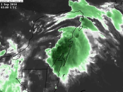
panamatropicwatch wrote:HH finding TS strength winds but heavy rain rate.


Well NNW of Merida, MX.
0 likes   
Carla/Alicia/Jerry(In The Eye)/Michelle/Charley/Ivan/Dennis/Katrina/Rita/Wilma/Ike/Harvey

Member: National Weather Association
Wx Infinity Forums
http://wxinfinity.com/index.php

Facebook.com/WeatherInfinity
Twitter @WeatherInfinity

User avatar
cycloneye
Admin
Admin
Posts: 145295
Age: 68
Joined: Thu Oct 10, 2002 10:54 am
Location: San Juan, Puerto Rico

Re: ATL: INVEST 99L - Discussion

#278 Postby cycloneye » Mon Sep 01, 2014 11:04 am

Plane is decending. Let's see if they can find a closed LLC.
0 likes   
Visit the Caribbean-Central America Weather Thread where you can find at first post web cams,radars
and observations from Caribbean basin members Click Here

User avatar
tropicwatch
Category 5
Category 5
Posts: 3383
Age: 61
Joined: Sat Jun 02, 2007 10:01 am
Location: Panama City Florida
Contact:

#279 Postby tropicwatch » Mon Sep 01, 2014 11:15 am

GE is now reporting plane position if someone wants to post graphics on recon.
0 likes   

tolakram
Admin
Admin
Posts: 20009
Age: 62
Joined: Sun Aug 27, 2006 8:23 pm
Location: Florence, KY (name is Mark)

Re: ATL: INVEST 99L - Discussion

#280 Postby tolakram » Mon Sep 01, 2014 11:52 am

0 likes   
M a r k
- - - - -
Join us in chat: Storm2K Chatroom Invite. Android and IOS apps also available.

The posts in this forum are NOT official forecasts and should not be used as such. Posts are NOT endorsed by any professional institution or STORM2K.org. For official information and forecasts, please refer to NHC and NWS products.


Return to “2014”

Who is online

Users browsing this forum: No registered users and 2 guests